Bridge Statistics for Eldorado, Ohio (OH)
Condition, Traffic, Stress, Structural Evaluation, Project Costs
- National Bridge Inventory (NBI) Statistics
- 13Number of bridges
- 56ft / 17.0mTotal length
- 8,981Total average daily traffic
- 622Total average daily truck traffic
- 12,377Total future (year 2035) average daily traffic
- National Bridge Inventory (NBI) Registered Bridges for Eldorado
- No street view available for this location
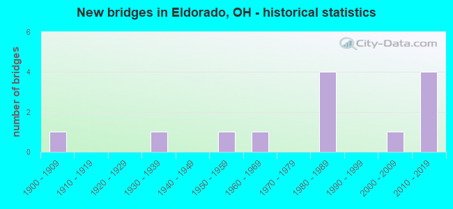
- New bridges - historical statistics
- 11900-1909
- 11930-1939
- 11950-1959
- 11960-1969
- 41980-1989
- 12000-2009
- 42010-2019

- Reconstructed bridges - Historical Statistics
- 11960-1969
- 01970-1979
- 01980-1989
- 01990-1999
- 12000-2009


- Bridge Condition - Deck
- 7.7%Excellent
- 46.2%Very good
- 15.4%Good
- 7.7%Fair
- 15.4%Poor
- 7.7%Serious

- Bridge Condition - Superstructure
- 7.7%Excellent
- 46.2%Very good
- 15.4%Good
- 7.7%Satisfactory
- 15.4%Fair
- 7.7%Poor

- Bridge Condition - Substructure
- 23.1%Excellent
- 30.8%Very good
- 15.4%Good
- 7.7%Satisfactory
- 7.7%Fair
- 15.4%Poor

- Bridge Condition - Channel
- 7.7%Excellent
- 38.5%Very good
- 15.4%Good
- 30.8%Satisfactory
- 7.7%Poor
Find on map >> Show street view
Structure Number: 1932403, Location: .28 MI E PRE CO-BUT TWP (Lat: 39.945789, Lng: -84.666219), Route carried "on" structure: County highway T0048, Year Built: 1983, Status: Open, Structure Length: 1.13m (3.71ft), Average Daily Traffic: 108 (year 2015), Truck Traffic: 7%, Average Future Daily Traffic: 150 (year 2035), Design Load: HS 20, Features Intersected: BRANCH MAPLE SWAMP, Facility Carried by Structure: OTTERBEIN-ITHACA
Minimum Vertical Clearance: 30+ m (98+ ft), Kilometerpoint: 4.860, Lanes on structure: 2, Owner: County Highway Agency, Approaching Roadway Width: 7.3m (24.0ft), Skew: 5 degrees, Material/Design: Prestressed concrete, Design/Construction: Box Beam or Girders - Multiple, Number Of Spans In Main Unit: 1, Length of Maximum Span: 11.3m (37.1ft), Curb-To-Curb Width: 7.3m (24.0ft), Out-to-Out Width: 7.3m (24.0ft)
Condition: Deck: Very good, Superstructure: Very good, Substructure: Very good, Channel: Very good, Operating Rating: 42.1 metric tons, Method Used To Determine Operating Rating: Load Factor (LF) rating reported by rating factor (RF) method using MS18 loading, Inventory Rating: 32.4 metric tons, Method Used To Determine Inventory Rating: Load Factor (LF) rating reported by rating factor (RF) method using MS18 loading, Structural Evaluation: Equal to present desirable criteria, Deck Geometry: Somewhat better than minimum adequacy, Waterway Adequacy: Equal to present minimum criteria, Approach Roadway Alignment: Better than present minimum criteria, Designated Inspection Frequency: Every 24 months, Inspection Date: July 2021, Deck Structure Type: Concrete Cast-file-Place, Wearing Surface/Protective System: Wearing Surface: Bituminous
Find on map >> Show street view
Structure Number: 6800521, Location: .6 MI W OF SR726 (Lat: 39.843081, Lng: -84.688389), Route carried "on" structure: US 40, Year Built: 1984, Year Reconstructed: 2021, Status: Open, Structure Length: 1.49m (4.89ft), Average Daily Traffic: 3,900 (year 2021), Truck Traffic: 5%, Average Future Daily Traffic: 5,458 (year 2041), Design Load: HL 93, Features Intersected: BANTAS FORK
Minimum Vertical Clearance: 30+ m (98+ ft), Kilometerpoint: 10.831, Lanes on structure: 2, Owner: State Highway Agency, Approaching Roadway Width: 11.0m (36.1ft), Skew: 1 degrees, Material/Design: Prestressed concrete, Design/Construction: Box Beam or Girders - Multiple, Number Of Spans In Main Unit: 1, Length of Maximum Span: 14.6m (47.9ft), Curb-To-Curb Width: 11.0m (36.1ft), Out-to-Out Width: 11.0m (36.1ft)
Condition: Deck: Very good, Superstructure: Very good, Substructure: Very good, Channel: Good, Operating Rating: 97.2 metric tons, Method Used To Determine Operating Rating: Load and Resistance Factor Rating (LRFR) rating reported by rating factor(RF) method using HL-93 loadings, Inventory Rating: 74.5 metric tons, Method Used To Determine Inventory Rating: Load and Resistance Factor Rating (LRFR) rating reported by rating factor(RF) method using HL-93 loadings, Structural Evaluation: Equal to present desirable criteria, Deck Geometry: Somewhat better than minimum adequacy, Waterway Adequacy: Equal to present desirable criteria, Approach Roadway Alignment: Superior to present desirable criteria, Designated Inspection Frequency: Every 12 months, Inspection Date: May 2021, Deck Structure Type: Concrete Cast-file-Place, Wearing Surface/Protective System: Wearing Surface: Monolithic Concrete, Deck Protection: Epoxy Coated Reinforcing
Find on map >> Show street view
Structure Number: 6804764, Location: AT ELDORADO S CORP LINE (Lat: 39.898969, Lng: -84.676461), Route carried "on" structure: State highway 726, Year Built: 1984, Status: Open, Structure Length: 1.65m (5.41ft), Average Daily Traffic: 1,744 (year 2015), Truck Traffic: 10%, Average Future Daily Traffic: 2,421 (year 2035), Design Load: HS 20+Mod, Features Intersected: PRICE CREEK
Minimum Vertical Clearance: 30+ m (98+ ft), Kilometerpoint: 14.001, Lanes on structure: 2, Owner: State Highway Agency, Approaching Roadway Width: 9.1m (29.9ft), Material/Design: Prestressed concrete, Design/Construction: Box Beam or Girders - Multiple, Number Of Spans In Main Unit: 1, Length of Maximum Span: 16.2m (53.1ft), Curb-To-Curb Width: 9.2m (30.2ft), Out-to-Out Width: 9.2m (30.2ft)
Condition: Deck: Good, Superstructure: Good, Substructure: Fair, Channel: Good, Operating Rating: 42.1 metric tons, Method Used To Determine Operating Rating: Load Factor (LF) rating reported by rating factor (RF) method using MS18 loading, Inventory Rating: 32.4 metric tons, Method Used To Determine Inventory Rating: Load Factor (LF) rating reported by rating factor (RF) method using MS18 loading, Structural Evaluation: Somewhat better than minimum adequacy, Deck Geometry: Somewhat better than minimum adequacy, Waterway Adequacy: Equal to present desirable criteria, Approach Roadway Alignment: Equal to present desirable criteria, Designated Inspection Frequency: Every 12 months, Inspection Date: April 2021, Deck Structure Type: Concrete Cast-file-Place, Wearing Surface/Protective System: Wearing Surface: Bituminous
Find on map >> Show street view
Structure Number: 6830316, Location: At CH9 Intersection (Lat: 39.872539, Lng: -84.652739), Route carried "on" structure: County highway C0012, Year Built: 2015, Status: Open, Structure Length: 1.95m (6.40ft), Average Daily Traffic: 235 (year 2015), Truck Traffic: 11%, Average Future Daily Traffic: 259 (year 2035), Design Load: HL 93, Features Intersected: Prices Creek, Facility Carried by Structure: Shurley Rd
Minimum Vertical Clearance: 30+ m (98+ ft), Kilometerpoint: 12.553, Lanes on structure: 2, Owner: County Highway Agency, Approaching Roadway Width: 8.5m (27.9ft), Material/Design: Prestressed concrete, Design/Construction: Box Beam or Girders - Multiple, Number Of Spans In Main Unit: 1, Length of Maximum Span: 18.3m (60.0ft), Curb-To-Curb Width: 8.5m (27.9ft), Out-to-Out Width: 8.5m (27.9ft)
Condition: Deck: Excellent, Superstructure: Excellent, Substructure: Excellent, Channel: Excellent, Operating Rating: 55.1 metric tons, Method Used To Determine Operating Rating: Load and Resistance Factor Rating (LRFR) rating reported by rating factor(RF) method using HL-93 loadings, Inventory Rating: 42.1 metric tons, Method Used To Determine Inventory Rating: Load and Resistance Factor Rating (LRFR) rating reported by rating factor(RF) method using HL-93 loadings, Structural Evaluation: Superior to present desirable criteria, Deck Geometry: Equal to present minimum criteria, Waterway Adequacy: Equal to present desirable criteria, Approach Roadway Alignment: Equal to present desirable criteria, Length Of Structure Improvement: 0.30m (0.98ft), Designated Inspection Frequency: Every 24 months, Inspection Date: June 2021, Deck Structure Type: Concrete Cast-file-Place, Wearing Surface/Protective System: Wearing Surface: Bituminous, Membrane: Preformed Fabric, Deck Protection: Epoxy Coated Reinforcing
Find on map >> Show street view
Structure Number: 6830471, Location: 1ST W OF SR 726 (Lat: 39.909181, Lng: -84.682869), Route carried "on" structure: County highway T0117, Year Built: 1930, Year Reconstructed: 2014, Status: Open, Structure Length: 1.01m (3.31ft), Average Daily Traffic: 193 (year 2015), Truck Traffic: 7%, Average Future Daily Traffic: 268 (year 2035), Design Load: HL 93, Features Intersected: PRICES CREEK, Facility Carried by Structure: ELDO WHITEWATER
Minimum Vertical Clearance: 30+ m (98+ ft), Kilometerpoint: 7.242, Lanes on structure: 2, Owner: County Highway Agency, Approaching Roadway Width: 6.7m (22.0ft), Skew: 2 degrees, Material/Design: Concrete, Design/Construction: Box Beam or Girders - Multiple, Number Of Spans In Main Unit: 1, Length of Maximum Span: 7.0m (23.0ft), Curb-To-Curb Width: 7.3m (24.0ft), Out-to-Out Width: 7.3m (24.0ft)
Condition: Deck: Very good, Superstructure: Very good, Substructure: Good, Channel: Very good, Operating Rating: 84.2 metric tons, Method Used To Determine Operating Rating: Load Factor (LF) rating reported by rating factor (RF) method using MS18 loading, Inventory Rating: 64.8 metric tons, Method Used To Determine Inventory Rating: Load Factor (LF) rating reported by rating factor (RF) method using MS18 loading, Structural Evaluation: Better than present minimum criteria, Deck Geometry: Somewhat better than minimum adequacy, Waterway Adequacy: Better than present minimum criteria, Approach Roadway Alignment: Equal to present desirable criteria, Length Of Structure Improvement: 0.91m (2.99ft), Designated Inspection Frequency: Every 24 months, Inspection Date: June 2021, Deck Structure Type: Concrete Cast-file-Place, Wearing Surface/Protective System: Wearing Surface: Bituminous, Membrane: Preformed Fabric, Deck Protection: Other
Find on map >> Show street view
Structure Number: 6830528, Location: .15 S OF SHURLEY RD (Lat: 39.870600, Lng: -84.652081), Route carried "on" structure: County highway C0009, Year Built: 1986, Status: Posted for load, Structure Length: 2.62m (8.60ft), Average Daily Traffic: 268 (year 2015), Truck Traffic: 7%, Average Future Daily Traffic: 372 (year 2035), Design Load: HS 20, Features Intersected: PRICES CREEK, Facility Carried by Structure: MONROE CENTRAL RD
Minimum Vertical Clearance: 30+ m (98+ ft), Kilometerpoint: 7.564, Lanes on structure: 2, Owner: County Highway Agency, Approaching Roadway Width: 7.3m (24.0ft), Material/Design: Prestressed concrete, Design/Construction: Box Beam or Girders - Multiple, Number Of Spans In Main Unit: 1, Length of Maximum Span: 25.0m (82.0ft), Curb-To-Curb Width: 7.3m (24.0ft), Out-to-Out Width: 7.3m (24.0ft)
Condition: Deck: Poor, Superstructure: Poor, Substructure: Good, Channel: Satisfactory, Operating Rating: 35.6 metric tons, Method Used To Determine Operating Rating: Load Factor (LF) rating reported by rating factor (RF) method using MS18 loading, Inventory Rating: 19.4 metric tons, Method Used To Determine Inventory Rating: Load Factor (LF) rating reported by rating factor (RF) method using MS18 loading, Structural Evaluation: Meets minimum limits, Deck Geometry: Somewhat better than minimum adequacy, Waterway Adequacy: Equal to present desirable criteria, Approach Roadway Alignment: Equal to present desirable criteria, Bridge Posting: Required (Relationship of Operating Rating to Maximum Legal Load: 10.0 - 19.9% below), Designated Inspection Frequency: Every 12 months, Inspection Date: June 2021, Deck Structure Type: Concrete Cast-file-Place, Wearing Surface/Protective System: Wearing Surface: Bituminous, Membrane: Preformed Fabric
Find on map >> Show street view
Structure Number: 6833268, Location: 1ST E OF CH 10 (Lat: 39.901861, Lng: -84.728339), Route carried "on" structure: County highway T0031, Year Built: 1960, Status: Posted for load, Structure Length: 0.73m (2.40ft), Average Daily Traffic: 420 (year 2015), Truck Traffic: 7%, Average Future Daily Traffic: 583 (year 2035), Design Load: H 15, Features Intersected: LITTLE CREEK, Facility Carried by Structure: B ROAD
Minimum Vertical Clearance: 30+ m (98+ ft), Kilometerpoint: 7.966, Lanes on structure: 2, Owner: County Highway Agency, Approaching Roadway Width: 6.7m (22.0ft), Material/Design: Concrete, Design/Construction: Slab, Number Of Spans In Main Unit: 1, Length of Maximum Span: 6.7m (22.0ft), Curb-To-Curb Width: 6.6m (21.7ft), Out-to-Out Width: 6.6m (21.7ft)
Condition: Deck: Poor, Superstructure: Fair, Substructure: Poor, Channel: Poor, Operating Rating: 38.9 metric tons, Method Used To Determine Operating Rating: Load Factor (LF) rating reported by rating factor (RF) method using MS18 loading, Inventory Rating: 22.7 metric tons, Method Used To Determine Inventory Rating: Load Factor (LF) rating reported by rating factor (RF) method using MS18 loading, Structural Evaluation: Meets minimum limits, Deck Geometry: High priority of corrective action, Waterway Adequacy: Equal to present desirable criteria, Approach Roadway Alignment: Equal to present desirable criteria, Bridge Posting: Required (Relationship of Operating Rating to Maximum Legal Load: 10.0 - 19.9% below), Designated Inspection Frequency: Every 12 months, Inspection Date: June 2021, Deck Structure Type: Concrete Cast-file-Place, Wearing Surface/Protective System: Wearing Surface: Bituminous
Find on map >> Show street view
Structure Number: 6833438, Location: .65 MI EAST OF CH 10 (Lat: 39.909219, Lng: -84.718931), Route carried "on" structure: County highway T0117, Year Built: 2005, Status: Open, Structure Length: 0.94m (3.08ft), Average Daily Traffic: 193 (year 2015), Truck Traffic: 7%, Average Future Daily Traffic: 268 (year 2035), Design Load: HS 20+Mod, Features Intersected: BRINLEY FORK, Facility Carried by Structure: WHITEWATER ELDORAD
Minimum Vertical Clearance: 30+ m (98+ ft), Kilometerpoint: 1.046, Lanes on structure: 2, Owner: County Highway Agency, Approaching Roadway Width: 7.3m (24.0ft), Material/Design: Concrete, Design/Construction: Box Beam or Girders - Multiple, Number Of Spans In Main Unit: 1, Length of Maximum Span: 8.2m (26.9ft), Curb-To-Curb Width: 7.3m (24.0ft), Out-to-Out Width: 7.3m (24.0ft)
Condition: Deck: Good, Superstructure: Good, Substructure: Very good, Channel: Satisfactory, Operating Rating: 42.1 metric tons, Method Used To Determine Operating Rating: Load Factor (LF) rating reported by rating factor (RF) method using MS18 loading, Inventory Rating: 32.4 metric tons, Method Used To Determine Inventory Rating: Load Factor (LF) rating reported by rating factor (RF) method using MS18 loading, Structural Evaluation: Better than present minimum criteria, Deck Geometry: Somewhat better than minimum adequacy, Waterway Adequacy: Equal to present desirable criteria, Approach Roadway Alignment: Equal to present desirable criteria, Designated Inspection Frequency: Every 24 months, Inspection Date: June 2021, Deck Structure Type: Concrete Cast-file-Place, Wearing Surface/Protective System: Wearing Surface: Bituminous, Membrane: Preformed Fabric, Deck Protection: Other
Find on map >> Show street view
Structure Number: 6840264, Location: .55 E OF SR 726 (Lat: 39.887261, Lng: -84.666900), Route carried "on" structure: County highway T0126, Year Built: 1950, Status: Posted for load, Structure Length: 1.59m (5.22ft), Average Daily Traffic: 324 (year 2015), Truck Traffic: 7%, Average Future Daily Traffic: 450 (year 2035), Features Intersected: PRICES CREEK, Facility Carried by Structure: KIMMEL RD
Minimum Vertical Clearance: 30+ m (98+ ft), Kilometerpoint: 3.219, Lanes on structure: 2, Owner: County Highway Agency, Approaching Roadway Width: 7.3m (24.0ft), Material/Design: Steel, Design/Construction: Stringer/Multi-beam, Number Of Spans In Main Unit: 1, Length of Maximum Span: 14.0m (45.9ft), Curb-To-Curb Width: 6.7m (22.0ft), Out-to-Out Width: 6.7m (22.0ft)
Condition: Deck: Serious, Superstructure: Satisfactory, Substructure: Satisfactory, Channel: Satisfactory, Operating Rating: 16.2 metric tons, Method Used To Determine Operating Rating: Load Factor (LF) rating reported by rating factor (RF) method using MS18 loading, Inventory Rating: 9.7 metric tons, Method Used To Determine Inventory Rating: Load Factor (LF) rating reported by rating factor (RF) method using MS18 loading, Structural Evaluation: High priority of corrective action, Deck Geometry: Meets minimum limits, Waterway Adequacy: Better than present minimum criteria, Approach Roadway Alignment: Equal to present desirable criteria, Bridge Posting: Required (Relationship of Operating Rating to Maximum Legal Load: > 39.9% below), Designated Inspection Frequency: Every 12 months, Inspection Date: June 2021, Deck Structure Type: Corrugated Steel, Wearing Surface/Protective System: Wearing Surface: Bituminous
Find on map >> Show street view
Structure Number: 6840418, Location: .20 W OF ELDORADO (Lat: 39.901950, Lng: -84.680961), Route carried "on" structure: County highway C0031, Year Built: 1900, Year Reconstructed: 1967, Status: Open, Structure Length: 0.94m (3.08ft), Average Daily Traffic: 769 (year 2015), Truck Traffic: 8%, Average Future Daily Traffic: 1,067 (year 2035), Design Load: HS 20, Features Intersected: PRICES CREEK, Facility Carried by Structure: PENCE SHEWMAN
Minimum Vertical Clearance: 30+ m (98+ ft), Kilometerpoint: 2.092, Lanes on structure: 2, Owner: County Highway Agency, Approaching Roadway Width: 8.2m (26.9ft), Material/Design: Prestressed concrete, Design/Construction: Box Beam or Girders - Multiple, Number Of Spans In Main Unit: 1, Length of Maximum Span: 7.9m (25.9ft), Curb-To-Curb Width: 7.3m (24.0ft), Out-to-Out Width: 7.3m (24.0ft)
Condition: Deck: Fair, Superstructure: Fair, Substructure: Poor, Channel: Satisfactory, Operating Rating: 55.1 metric tons, Method Used To Determine Operating Rating: Load Factor (LF) rating reported by rating factor (RF) method using MS18 loading, Inventory Rating: 32.4 metric tons, Method Used To Determine Inventory Rating: Load Factor (LF) rating reported by rating factor (RF) method using MS18 loading, Structural Evaluation: Meets minimum limits, Deck Geometry: Meets minimum limits, Waterway Adequacy: Equal to present desirable criteria, Approach Roadway Alignment: Equal to present desirable criteria, Designated Inspection Frequency: Every 12 months, Inspection Date: June 2021, Deck Structure Type: Concrete Cast-file-Place, Wearing Surface/Protective System: Wearing Surface: Bituminous
Find on map >> Show street view
Structure Number: 6840478, Location: Second bridge W of CR9 (Lat: 39.872650, Lng: -84.668269), Route carried "on" structure: County highway C0012, Year Built: 2015, Status: Open, Structure Length: 0.94m (3.08ft), Average Daily Traffic: 235 (year 2015), Truck Traffic: 11%, Average Future Daily Traffic: 259 (year 2035), Design Load: HL 93, Features Intersected: Tributary, Facility Carried by Structure: Shurley Rd
Minimum Vertical Clearance: 30+ m (98+ ft), Kilometerpoint: 11.185, Lanes on structure: 2, Owner: County Highway Agency, Approaching Roadway Width: 8.2m (26.9ft), Material/Design: Concrete, Design/Construction: Box Beam or Girders - Multiple, Number Of Spans In Main Unit: 1, Length of Maximum Span: 8.2m (26.9ft), Curb-To-Curb Width: 8.2m (26.9ft), Out-to-Out Width: 8.2m (26.9ft)
Condition: Deck: Very good, Superstructure: Very good, Substructure: Excellent, Channel: Very good, Operating Rating: 55.1 metric tons, Method Used To Determine Operating Rating: Load and Resistance Factor Rating (LRFR) rating reported by rating factor(RF) method using HL-93 loadings, Inventory Rating: 42.1 metric tons, Method Used To Determine Inventory Rating: Load and Resistance Factor Rating (LRFR) rating reported by rating factor(RF) method using HL-93 loadings, Structural Evaluation: Equal to present desirable criteria, Deck Geometry: Somewhat better than minimum adequacy, Waterway Adequacy: Equal to present minimum criteria, Approach Roadway Alignment: Equal to present desirable criteria, Length Of Structure Improvement: 0.30m (0.98ft), Designated Inspection Frequency: Every 24 months, Inspection Date: June 2021, Deck Structure Type: Concrete Cast-file-Place, Wearing Surface/Protective System: Wearing Surface: Bituminous, Membrane: Preformed Fabric, Deck Protection: Other
Find on map >> Show street view
Structure Number: 6840523, Location: 100 FT. E.PENCE SHEWMAN (Lat: 39.858031, Lng: -84.696681), Route carried "on" structure: County highway T0128, Year Built: 2011, Status: Open, Structure Length: 1.22m (4.00ft), Average Daily Traffic: 324 (year 2015), Truck Traffic: 7%, Average Future Daily Traffic: 450 (year 2035), Design Load: HS 25 or greater, Features Intersected: BANTAS FORK CREEK, Facility Carried by Structure: CRUBAUGH RD.
Minimum Vertical Clearance: 30+ m (98+ ft), Kilometerpoint: 0.644, Lanes on structure: 2, Owner: County Highway Agency, Approaching Roadway Width: 7.3m (24.0ft), Skew: 3 degrees, Material/Design: Concrete, Design/Construction: Box Beam or Girders - Multiple, Number Of Spans In Main Unit: 1, Length of Maximum Span: 11.0m (36.1ft), Curb-To-Curb Width: 7.3m (24.0ft), Out-to-Out Width: 7.3m (24.0ft)
Condition: Deck: Very good, Superstructure: Very good, Substructure: Excellent, Channel: Very good, Operating Rating: 97.2 metric tons, Method Used To Determine Operating Rating: Load and Resistance Factor Rating (LRFR) rating reported by rating factor(RF) method using HL-93 loadings, Inventory Rating: 77.8 metric tons, Method Used To Determine Inventory Rating: Load and Resistance Factor Rating (LRFR) rating reported by rating factor(RF) method using HL-93 loadings, Structural Evaluation: Equal to present desirable criteria, Deck Geometry: Somewhat better than minimum adequacy, Waterway Adequacy: Equal to present desirable criteria, Approach Roadway Alignment: High priority of corrective action, Designated Inspection Frequency: Every 24 months, Inspection Date: June 2021, Deck Structure Type: Concrete Cast-file-Place, Wearing Surface/Protective System: Wearing Surface: Bituminous, Membrane: Preformed Fabric, Deck Protection: Other
Find on map >> Show street view
Structure Number: 6840558, Location: JUST SOUTH OF FOOS RD. (Lat: 39.862681, Lng: -84.652061), Route carried "on" structure: County highway C0009, Year Built: 2012, Status: Open, Structure Length: 0.79m (2.59ft), Average Daily Traffic: 268 (year 2015), Truck Traffic: 7%, Average Future Daily Traffic: 372 (year 2035), Design Load: HL 93, Features Intersected: STREAM, Facility Carried by Structure: MONROE-CENTRAL RD.
Minimum Vertical Clearance: 30+ m (98+ ft), Kilometerpoint: 6.679, Lanes on structure: 2, Owner: County Highway Agency, Approaching Roadway Width: 8.2m (26.9ft), Material/Design: Concrete, Design/Construction: Box Beam or Girders - Multiple, Number Of Spans In Main Unit: 1, Length of Maximum Span: 6.7m (22.0ft), Curb-To-Curb Width: 8.2m (26.9ft), Out-to-Out Width: 8.2m (26.9ft)
Condition: Deck: Very good, Superstructure: Very good, Substructure: Very good, Channel: Very good, Operating Rating: 97.2 metric tons, Method Used To Determine Operating Rating: Load and Resistance Factor Rating (LRFR) rating reported by rating factor(RF) method using HL-93 loadings, Inventory Rating: 77.8 metric tons, Method Used To Determine Inventory Rating: Load and Resistance Factor Rating (LRFR) rating reported by rating factor(RF) method using HL-93 loadings, Structural Evaluation: Equal to present desirable criteria, Deck Geometry: Somewhat better than minimum adequacy, Waterway Adequacy: Equal to present desirable criteria, Approach Roadway Alignment: Equal to present desirable criteria, Designated Inspection Frequency: Every 24 months, Inspection Date: June 2021, Deck Structure Type: Concrete Cast-file-Place, Wearing Surface/Protective System: Wearing Surface: Bituminous, Membrane: Preformed Fabric, Deck Protection: Other