Bridge Statistics for El Moro, Colorado (CO)
Condition, Traffic, Stress, Structural Evaluation, Project Costs
- National Bridge Inventory (NBI) Statistics
- 20Number of bridges
- 161ft / 49.0mTotal length
- $5,107,000Total costs
- 33,206Total average daily traffic
- 5,711Total average daily truck traffic
- 40,202Total future (year 2038) average daily traffic
- National Bridge Inventory (NBI) Registered Bridges for El Moro
- No street view available for this location
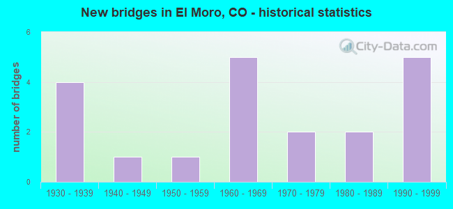
- New bridges - historical statistics
- 41930-1939
- 11940-1949
- 11950-1959
- 51960-1969
- 21970-1979
- 21980-1989
- 51990-1999

- Reconstructed bridges - Historical Statistics
- 11950-1959
- 01960-1969
- 01970-1979
- 11980-1989
- 11990-1999


- Bridge Condition - Deck
- 5.9%Very good
- 23.5%Good
- 17.6%Satisfactory
- 35.3%Fair
- 17.6%Poor

- Bridge Condition - Superstructure
- 17.6%Very good
- 29.4%Good
- 5.9%Satisfactory
- 35.3%Fair
- 11.8%Poor

- Bridge Condition - Substructure
- 5.9%Very good
- 41.2%Good
- 11.8%Satisfactory
- 11.8%Fair
- 23.5%Poor
- 5.9%Serious

- Bridge Condition - Channel
- 23.5%Very good
- 41.2%Good
- 17.6%Satisfactory
- 11.8%Fair
- 5.9%Serious

- Bridge Condition - Culverts
- 33.3%Very good
- 33.3%Fair
- 33.3%Critical
Find on map >> Show street view
Structure Number: LA32-38-16-146, Location: 0.28 MI E of Co Rd 75 (Lat: 37.220797, Lng: -104.461758), Route carried "on" structure: County highway , Year Built: 1970, Status: Open, Structure Length: 1.21m (3.97ft), Average Daily Traffic: 6 (year 2018), Average Future Daily Traffic: 18 (year 2038), Features Intersected: Feeder Ditch, Facility Carried by Structure: CO Rd 32
Minimum Vertical Clearance: 30+ m (98+ ft), Kilometerpoint: 0.541, Lanes on structure: 1, Owner: County Highway Agency, Approaching Roadway Width: 3.7m (12.1ft), Material/Design: Steel, Design/Construction: Girder and Floorbeam System, Number Of Spans In Main Unit: 1, Length of Maximum Span: 10.4m (34.1ft), Curb-To-Curb Width: 4.1m (13.5ft), Out-to-Out Width: 4.2m (13.8ft)
Condition: Deck: Fair, Superstructure: Fair, Substructure: Serious, Channel: Serious, Operating Rating: 4.5 metric tons, Method Used To Determine Operating Rating: Field evaluation and documented engineering judgment, Inventory Rating: 2.7 metric tons, Method Used To Determine Inventory Rating: Field evaluation and documented engineering judgment, Structural Evaluation: High priority of replacement, Deck Geometry: Somewhat better than minimum adequacy, Waterway Adequacy: Equal to present desirable criteria, Approach Roadway Alignment: Equal to present desirable criteria, Bridge Posting: Required (Relationship of Operating Rating to Maximum Legal Load: > 39.9% below), Length Of Structure Improvement: 1.37m (4.49ft), Designated Inspection Frequency: Every 12 months, Inspection Date: June 2021, Bridge Improvement Cost: $311,000, Roadway Improvement Cost: $31,000, Total Project Cost: $342,000 ( Estimate for 2020), Deck Structure Type: Steel plate, Wearing Surface/Protective System: Wearing Surface: Other
Find on map >> Show street view
Structure Number: LA324-38-16-133, Location: 1.2 MI E OF I-25 (Lat: 37.224439, Lng: -104.469617), Route carried "on" structure: County highway , Year Built: 1970, Year Reconstructed: 1980, Status: Open, Structure Length: 0.95m (3.12ft), Average Daily Traffic: 380 (year 2018), Truck Traffic: 2%, Average Future Daily Traffic: 616 (year 2038), Features Intersected: PICKETWIRE DITCH, Facility Carried by Structure: COUNTY RD 32.4
Minimum Vertical Clearance: 30+ m (98+ ft), Kilometerpoint: 2.245, Lanes on structure: 1, Owner: County Highway Agency, Approaching Roadway Width: 5.5m (18.0ft), Material/Design: Steel, Design/Construction: Stringer/Multi-beam, Number Of Spans In Main Unit: 1, Length of Maximum Span: 8.7m (28.5ft), Curb-To-Curb Width: 4.8m (15.7ft), Out-to-Out Width: 4.8m (15.7ft)
Condition: Deck: Fair, Superstructure: Fair, Substructure: Poor, Channel: Very good, Operating Rating: 25.9 metric tons, Method Used To Determine Operating Rating: Load Factor (LF), Inventory Rating: 15.5 metric tons, Method Used To Determine Inventory Rating: Load Factor (LF), Structural Evaluation: Meets minimum limits, Deck Geometry: High priority of corrective action, Waterway Adequacy: Better than present minimum criteria, Approach Roadway Alignment: Better than present minimum criteria, Length Of Structure Improvement: 1.62m (5.31ft), Designated Inspection Frequency: Every 24 months, Inspection Date: May 2021, Bridge Improvement Cost: $678,000, Roadway Improvement Cost: $170,000, Total Project Cost: $848,000 ( Estimate for 2019), Deck Structure Type: Open Grating, Wearing Surface/Protective System: Wearing Surface: Other
Find on map >> Show street view
Structure Number: LA36-41-18-62A, Location: .4 MI S OF CR 75.1 (Lat: 37.247908, Lng: -104.405367), Route carried "on" structure: County highway , Year Built: 1994, Status: Open, Structure Length: 5.24m (17.19ft), Average Daily Traffic: 60 (year 2018), Average Future Daily Traffic: 98 (year 2038), Design Load: HS 20, Features Intersected: PURGATOIRE RIVER, Facility Carried by Structure: COUNTY RD 36.0
Minimum Vertical Clearance: 30+ m (98+ ft), Kilometerpoint: 0.838, Lanes on structure: 2, Owner: County Highway Agency, Approaching Roadway Width: 7.3m (24.0ft), Material/Design: Steel continuous, Design/Construction: Stringer/Multi-beam, Number Of Spans In Main Unit: 3, Length of Maximum Span: 18.9m (62.0ft), Curb-To-Curb Width: 8.7m (28.5ft), Out-to-Out Width: 9.4m (30.8ft)
Condition: Deck: Satisfactory, Superstructure: Very good, Substructure: Good, Channel: Good, Operating Rating: 77.0 metric tons, Method Used To Determine Operating Rating: Load Factor (LF), Inventory Rating: 46.2 metric tons, Method Used To Determine Inventory Rating: Load Factor (LF), Structural Evaluation: Better than present minimum criteria, Deck Geometry: Better than present minimum criteria, Waterway Adequacy: Equal to present desirable criteria, Approach Roadway Alignment: Better than present minimum criteria, Designated Inspection Frequency: Every 24 months, Inspection Date: June 2021, Deck Structure Type: Concrete Cast-file-Place, Wearing Surface/Protective System: Wearing Surface: Monolithic Concrete, Deck Protection: Epoxy Coated Reinforcing
Find on map >> Show street view
Structure Number: LA75-38-17-128, Location: 1.0 MI N OF CR 32.4 (Lat: 37.238578, Lng: -104.466458), Route carried "on" structure: County highway , Year Built: 1930, Year Reconstructed: 1950, Status: Open, Structure Length: 0.92m (3.02ft), Average Daily Traffic: 145 (year 2018), Truck Traffic: 2%, Average Future Daily Traffic: 235 (year 2038), Features Intersected: PICKETWIRE DITCH, Facility Carried by Structure: COUNTY RD 75.0
Minimum Vertical Clearance: 30+ m (98+ ft), Kilometerpoint: 2.092, Lanes on structure: 2, Owner: County Highway Agency, Approaching Roadway Width: 6.1m (20.0ft), Material/Design: Steel, Design/Construction: Stringer/Multi-beam, Number Of Spans In Main Unit: 1, Length of Maximum Span: 8.9m (29.2ft), Curb-To-Curb Width: 6.7m (22.0ft), Out-to-Out Width: 6.7m (22.0ft)
Condition: Deck: Good, Superstructure: Fair, Substructure: Good, Channel: Good, Operating Rating: 38.8 metric tons, Method Used To Determine Operating Rating: Load Factor (LF), Inventory Rating: 23.2 metric tons, Method Used To Determine Inventory Rating: Load Factor (LF), Structural Evaluation: Somewhat better than minimum adequacy, Deck Geometry: Meets minimum limits, Waterway Adequacy: Equal to present desirable criteria, Approach Roadway Alignment: Equal to present desirable criteria, Length Of Structure Improvement: 1.25m (4.10ft), Designated Inspection Frequency: Every 24 months, Inspection Date: May 2021, Bridge Improvement Cost: $664,000, Roadway Improvement Cost: $66,000, Total Project Cost: $830,000 ( Estimate for 2019), Deck Structure Type: Corrugated Steel, Wearing Surface/Protective System: Wearing Surface: Gravel
Find on map >> Show street view
Structure Number: LA75-38-17-52A, Location: 0.7 MI N OF CR 32.4 (Lat: 37.234664, Lng: -104.466522), Route carried "on" structure: County highway , Year Built: 1984, Status: Open, Structure Length: 0.69m (2.26ft), Average Daily Traffic: 157 (year 2018), Truck Traffic: 2%, Average Future Daily Traffic: 254 (year 2038), Design Load: HS 20+Mod, Features Intersected: UNNAMED NATURAL DRAINAGE, Facility Carried by Structure: COUNTY RD 75.0
Minimum Vertical Clearance: 30+ m (98+ ft), Kilometerpoint: 1.666, Lanes on structure: 2, Owner: County Highway Agency, Approaching Roadway Width: 6.7m (22.0ft), Skew: 4 degrees, Material/Design: Steel, Design/Construction: Culvert, Number Of Spans In Main Unit: 1, Length of Maximum Span: 6.9m (22.6ft), Out-to-Out Width: 11.1m (36.4ft)
Condition: Channel: Satisfactory, Culverts: Fair, Operating Rating: 15.5 metric tons, Method Used To Determine Operating Rating: Load Factor (LF), Inventory Rating: 9.3 metric tons, Method Used To Determine Inventory Rating: Load Factor (LF), Structural Evaluation: High priority of corrective action, Waterway Adequacy: Equal to present minimum criteria, Approach Roadway Alignment: Equal to present minimum criteria, Bridge Posting: Required (Relationship of Operating Rating to Maximum Legal Load: 20.0 - 29.9% below), Designated Inspection Frequency: Every 24 months, Inspection Date: May 2021
Find on map >> Show street view
Structure Number: LA75-38-20-53, Location: 1.4 MI S OF HOEHNE RD (Lat: 37.273344, Lng: -104.467467), Route carried "on" structure: County highway , Year Built: 1950, Status: Open, Structure Length: 0.91m (2.99ft), Average Daily Traffic: 97 (year 2018), Truck Traffic: 2%, Average Future Daily Traffic: 157 (year 2038), Features Intersected: LEITENSDORFER ARROYO, Facility Carried by Structure: COUNTY RD 75.0
Minimum Vertical Clearance: 30+ m (98+ ft), Kilometerpoint: 5.890, Lanes on structure: 2, Owner: County Highway Agency, Approaching Roadway Width: 6.1m (20.0ft), Skew: 1 degrees, Material/Design: Steel, Design/Construction: Girder and Floorbeam System, Number Of Spans In Main Unit: 1, Length of Maximum Span: 7.9m (25.9ft), Curb-To-Curb Width: 7.3m (24.0ft), Out-to-Out Width: 7.5m (24.6ft)
Condition: Deck: Poor, Superstructure: Fair, Substructure: Poor, Channel: Fair, Operating Rating: 11.9 metric tons, Method Used To Determine Operating Rating: Load Factor (LF), Inventory Rating: 7.1 metric tons, Method Used To Determine Inventory Rating: Load Factor (LF), Structural Evaluation: High priority of replacement, Deck Geometry: Equal to present minimum criteria, Waterway Adequacy: Equal to present desirable criteria, Approach Roadway Alignment: High priority of corrective action, Bridge Posting: Required (Relationship of Operating Rating to Maximum Legal Load: > 39.9% below), Length Of Structure Improvement: 1.58m (5.18ft), Designated Inspection Frequency: Every 12 months, Critical Feature Inspection Frequency: Every 12 months, Inspection Date: May 2021, Critical Feature Inspection Date: May 2021, Bridge Improvement Cost: $670,000, Roadway Improvement Cost: $67,000, Total Project Cost: $737,000 ( Estimate for 2020), Deck Structure Type: Concrete Cast-file-Place, Wearing Surface/Protective System: Wearing Surface: Monolithic Concrete
Find on map >> Show street view
Structure Number: LA75-38-22-54A, Location: .7 MI N OF HOEHNE RD (Lat: 37.304319, Lng: -104.466458), Route carried "on" structure: County highway , Year Built: 1993, Status: Open, Structure Length: 2.74m (8.99ft), Average Daily Traffic: 22 (year 2018), Average Future Daily Traffic: 36 (year 2038), Design Load: HS 20, Features Intersected: CHICOSA CANYON CREEK, Facility Carried by Structure: COUNTY RD 75.0
Minimum Vertical Clearance: 30+ m (98+ ft), Kilometerpoint: 9.157, Lanes on structure: 2, Owner: County Highway Agency, Approaching Roadway Width: 6.1m (20.0ft), Material/Design: Prestressed concrete, Design/Construction: Stringer/Multi-beam, Number Of Spans In Main Unit: 1, Length of Maximum Span: 25.9m (85.0ft), Curb-To-Curb Width: 9.1m (29.9ft), Out-to-Out Width: 9.9m (32.5ft)
Condition: Deck: Satisfactory, Superstructure: Good, Substructure: Good, Channel: Satisfactory, Operating Rating: 72.7 metric tons, Method Used To Determine Operating Rating: Load Factor (LF), Inventory Rating: 43.6 metric tons, Method Used To Determine Inventory Rating: Load Factor (LF), Structural Evaluation: Better than present minimum criteria, Deck Geometry: Better than present minimum criteria, Waterway Adequacy: Equal to present desirable criteria, Approach Roadway Alignment: Equal to present desirable criteria, Designated Inspection Frequency: Every 24 months, Inspection Date: May 2021, Deck Structure Type: Concrete Cast-file-Place, Wearing Surface/Protective System: Wearing Surface: Monolithic Concrete, Deck Protection: Epoxy Coated Reinforcing
Find on map >> Show street view
Structure Number: LA75.1-41-18-61, Location: .2 MI NE OF CR 36 (Lat: 37.252969, Lng: -104.410664), Route carried "on" structure: County highway , Year Built: 1935, Year Reconstructed: 2001, Status: Open, Structure Length: 1.28m (4.20ft), Average Daily Traffic: 331 (year 2018), Truck Traffic: 2%, Average Future Daily Traffic: 537 (year 2038), Features Intersected: LEITENSDORFER ARROYO, Facility Carried by Structure: COUNTY RD 75.1
Minimum Vertical Clearance: 30+ m (98+ ft), Kilometerpoint: 7.585, Lanes on structure: 2, Owner: County Highway Agency, Approaching Roadway Width: 6.7m (22.0ft), Material/Design: Concrete, Design/Construction: Arch - Deck, Number Of Spans In Main Unit: 1, Length of Maximum Span: 12.8m (42.0ft), Curb-To-Curb Width: 7.8m (25.6ft), Out-to-Out Width: 8.0m (26.2ft)
Condition: Deck: Fair, Superstructure: Poor, Substructure: Poor, Channel: Good, Operating Rating: 32.7 metric tons, Method Used To Determine Operating Rating: Field evaluation and documented engineering judgment, Inventory Rating: 24.5 metric tons, Method Used To Determine Inventory Rating: Field evaluation and documented engineering judgment, Structural Evaluation: Meets minimum limits, Deck Geometry: Somewhat better than minimum adequacy, Waterway Adequacy: Equal to present desirable criteria, Approach Roadway Alignment: Equal to present desirable criteria, Designated Inspection Frequency: Every 24 months, Inspection Date: June 2021, Bridge Improvement Cost: $1,090,000, Roadway Improvement Cost: $109,000, Total Project Cost: $1,363,000 ( Estimate for 2019), Deck Structure Type: Concrete Cast-file-Place, Wearing Surface/Protective System: Wearing Surface: Bituminous
Find on map >> Show street view
Structure Number: LA751-38-15-50B, Location: .3 MI S OF CR 32.0 (Lat: 37.215617, Lng: -104.464672), Route carried "on" structure: County highway , Year Built: 1998, Status: Open, Structure Length: 6.10m (20.01ft), Average Daily Traffic: 249 (year 2018), Truck Traffic: 2%, Average Future Daily Traffic: 403 (year 2038), Design Load: HS 20, Features Intersected: PURGATOIRE RIVER, Facility Carried by Structure: COUNTY RD 75.1
Minimum Vertical Clearance: 30+ m (98+ ft), Kilometerpoint: 0.849, Lanes on structure: 2, Owner: County Highway Agency, Approaching Roadway Width: 8.5m (27.9ft), Skew: 3 degrees, Material/Design: Steel continuous, Design/Construction: Stringer/Multi-beam, Number Of Spans In Main Unit: 3, Length of Maximum Span: 22.7m (74.5ft), Curb-To-Curb Width: 9.1m (29.9ft), Out-to-Out Width: 9.9m (32.5ft)
Condition: Deck: Satisfactory, Superstructure: Good, Substructure: Good, Channel: Good, Operating Rating: 80.0 metric tons, Method Used To Determine Operating Rating: Load Factor (LF), Inventory Rating: 48.0 metric tons, Method Used To Determine Inventory Rating: Load Factor (LF), Structural Evaluation: Better than present minimum criteria, Deck Geometry: Equal to present minimum criteria, Waterway Adequacy: Equal to present desirable criteria, Approach Roadway Alignment: Equal to present minimum criteria, Designated Inspection Frequency: Every 24 months, Inspection Date: June 2021, Deck Structure Type: Concrete Cast-file-Place, Wearing Surface/Protective System: Wearing Surface: Bituminous, Deck Protection: Epoxy Coated Reinforcing
Find on map >> Show street view
Structure Number: LA751-39-17-51A, Location: 1 MI E OF SH 239 (Lat: 37.227272, Lng: -104.452242), Route carried "on" structure: County highway , Year Built: 1983, Status: Temporarily open, Structure Length: 0.67m (2.20ft), Average Daily Traffic: 502 (year 2018), Truck Traffic: 2%, Average Future Daily Traffic: 814 (year 2038), Design Load: HS 20+Mod, Features Intersected: FEEDER DITCH, Facility Carried by Structure: COUNTY RD 75.1
Minimum Vertical Clearance: 30+ m (98+ ft), Kilometerpoint: 2.812, Lanes on structure: 2, Owner: County Highway Agency, Approaching Roadway Width: 6.4m (21.0ft), Skew: 5 degrees, Material/Design: Steel, Design/Construction: Culvert, Number Of Spans In Main Unit: 1, Length of Maximum Span: 6.7m (22.0ft), Out-to-Out Width: 10.7m (35.1ft)
Condition: Channel: Fair, Culverts: Critical, Structural Evaluation: High priority of replacement, Waterway Adequacy: Equal to present minimum criteria, Approach Roadway Alignment: Equal to present desirable criteria, Designated Inspection Frequency: Every 6 months, Inspection Date: December 2021
Find on map >> Show street view
Structure Number: LA79-40-18-60A, Location: 1.1 MI N OF CR 75.1 (Lat: 37.257131, Lng: -104.430094), Route carried "on" structure: County highway , Year Built: 1990, Status: Open, Structure Length: 1.22m (4.00ft), Average Daily Traffic: 38 (year 2018), Average Future Daily Traffic: 62 (year 2038), Design Load: HS 20, Features Intersected: LEITENSDORFER ARROYO, Facility Carried by Structure: COUNTY RD 79.0
Minimum Vertical Clearance: 30+ m (98+ ft), Kilometerpoint: 1.580, Lanes on structure: 2, Owner: County Highway Agency, Approaching Roadway Width: 6.4m (21.0ft), Skew: 4 degrees, Material/Design: Steel, Design/Construction: Stringer/Multi-beam, Number Of Spans In Main Unit: 1, Length of Maximum Span: 11.3m (37.1ft), Curb-To-Curb Width: 9.1m (29.9ft), Out-to-Out Width: 9.1m (29.9ft)
Condition: Deck: Good, Superstructure: Good, Substructure: Good, Channel: Good, Operating Rating: 62.8 metric tons, Method Used To Determine Operating Rating: Load Factor (LF), Inventory Rating: 37.6 metric tons, Method Used To Determine Inventory Rating: Load Factor (LF), Structural Evaluation: Better than present minimum criteria, Deck Geometry: Better than present minimum criteria, Waterway Adequacy: Equal to present desirable criteria, Approach Roadway Alignment: Equal to present desirable criteria, Designated Inspection Frequency: Every 24 months, Inspection Date: June 2021, Deck Structure Type: Concrete Cast-file-Place, Wearing Surface/Protective System: Wearing Surface: Monolithic Concrete, Deck Protection: Epoxy Coated Reinforcing
Find on map >> Show street view
Structure Number: LA79-40-19-59, Location: .2 MI S OF CR 38 (Lat: 37.261033, Lng: -104.430533), Route carried "on" structure: County highway , Year Built: 1945, Status: Posted for load, Structure Length: 1.23m (4.04ft), Average Daily Traffic: 39 (year 2018), Average Future Daily Traffic: 63 (year 2038), Features Intersected: FEEDER DITCH, Facility Carried by Structure: COUNTY RD 79.0
Minimum Vertical Clearance: 30+ m (98+ ft), Kilometerpoint: 1.994, Lanes on structure: 1, Owner: County Highway Agency, Approaching Roadway Width: 4.3m (14.1ft), Material/Design: Concrete, Design/Construction: Girder and Floorbeam System, Number Of Spans In Main Unit: 1, Length of Maximum Span: 11.9m (39.0ft), Curb-To-Curb Width: 4.2m (13.8ft), Out-to-Out Width: 4.9m (16.1ft)
Condition: Deck: Poor, Superstructure: Poor, Substructure: Poor, Channel: Good, Operating Rating: 9.1 metric tons, Method Used To Determine Operating Rating: Field evaluation and documented engineering judgment, Inventory Rating: 7.3 metric tons, Method Used To Determine Inventory Rating: Field evaluation and documented engineering judgment, Structural Evaluation: High priority of replacement, Deck Geometry: Somewhat better than minimum adequacy, Waterway Adequacy: Better than present minimum criteria, Approach Roadway Alignment: Equal to present minimum criteria, Bridge Posting: Required (Relationship of Operating Rating to Maximum Legal Load: > 39.9% below), Length Of Structure Improvement: 1.92m (6.30ft), Designated Inspection Frequency: Every 12 months, Inspection Date: June 2021, Bridge Improvement Cost: $897,000, Roadway Improvement Cost: $90,000, Total Project Cost: $987,000 ( Estimate for 2020), Deck Structure Type: Concrete Cast-file-Place, Wearing Surface/Protective System: Wearing Surface: Gravel
Find on map >> Show street view
Structure Number: O-18-CE, Location: 7.5 MI NO OF JCT SH 239 (Lat: 37.287256, Lng: -104.519717), Route carried "on" structure: Interstate 25A, Year Built: 1969, Status: Open, Structure Length: 2.74m (8.99ft), Average Daily Traffic: 6,000 (year 2020), Truck Traffic: 20%, Average Future Daily Traffic: 7,140 (year 2040), Design Load: HS 20+Mod, Features Intersected: TINGLEY CANYON, Facility Carried by Structure: I 25 ML NBND
Minimum Vertical Clearance: 30+ m (98+ ft), Kilometerpoint: 35.990, Lanes on structure: 2, Base Highway Network: Yes, Owner: State Highway Agency, Approaching Roadway Width: 11.6m (38.1ft), Skew: 10 degrees, Material/Design: Prestressed concrete, Design/Construction: Tee Beam, Number Of Spans In Main Unit: 1, Length of Maximum Span: 26.8m (87.9ft), Curb-To-Curb Width: 11.7m (38.4ft), Out-to-Out Width: 12.4m (40.7ft)
Condition: Deck: Fair, Superstructure: Fair, Substructure: Fair, Channel: Very good, Operating Rating: 51.7 metric tons, Method Used To Determine Operating Rating: Load Factor (LF), Inventory Rating: 30.9 metric tons, Method Used To Determine Inventory Rating: Load Factor (LF), Structural Evaluation: Somewhat better than minimum adequacy, Deck Geometry: Equal to present minimum criteria, Waterway Adequacy: Equal to present desirable criteria, Approach Roadway Alignment: Equal to present desirable criteria, Designated Inspection Frequency: Every 24 months, Inspection Date: August 2020, Deck Structure Type: Other, Wearing Surface/Protective System: Wearing Surface: Bituminous, Membrane: Preformed Fabric
Find on map >> Show street view
Structure Number: O-18-CO, Location: 11.7 MI S OF AGUILAR RD (Lat: 37.286914, Lng: -104.519939), Route carried "on" structure: Interstate 25A, Year Built: 1997, Status: Open, Structure Length: 4.85m (15.91ft), Average Daily Traffic: 6,000 (year 2020), Truck Traffic: 20%, Average Future Daily Traffic: 7,140 (year 2040), Design Load: HS 25 or greater, Features Intersected: TINGLEY CANYON, Facility Carried by Structure: I 25 ML SBND
Minimum Vertical Clearance: 30+ m (98+ ft), Kilometerpoint: 35.975, Lanes on structure: 2, Base Highway Network: Yes, Owner: State Highway Agency, Approaching Roadway Width: 11.6m (38.1ft), Material/Design: Prestressed concrete continuous, Design/Construction: Stringer/Multi-beam, Number Of Spans In Main Unit: 2, Length of Maximum Span: 23.9m (78.4ft), Curb-To-Curb Width: 11.6m (38.1ft), Out-to-Out Width: 12.3m (40.4ft)
Condition: Deck: Very good, Superstructure: Very good, Substructure: Good, Channel: Very good, Operating Rating: 59.4 metric tons, Method Used To Determine Operating Rating: Load Factor (LF), Inventory Rating: 35.7 metric tons, Method Used To Determine Inventory Rating: Load Factor (LF), Structural Evaluation: Better than present minimum criteria, Deck Geometry: Equal to present minimum criteria, Waterway Adequacy: Equal to present desirable criteria, Approach Roadway Alignment: Equal to present desirable criteria, Designated Inspection Frequency: Every 48 months, Inspection Date: July 2018, Deck Structure Type: Concrete Cast-file-Place, Wearing Surface/Protective System: Wearing Surface: Bituminous, Deck Protection: Epoxy Coated Reinforcing
Find on map >> Show street view
Structure Number: P-19-AW, Location: 4.9 MI NO OF JCT SH 239 (Lat: 37.253267, Lng: -104.500492), Route carried "on" structure: Interstate 25A, Year Built: 1969, Status: Open, Structure Length: 5.63m (18.47ft), Average Daily Traffic: 6,000 (year 2020), Truck Traffic: 20%, Average Future Daily Traffic: 7,140 (year 2040), Design Load: HS 20+Mod, Features Intersected: RR SPUR, Facility Carried by Structure: I 25 ML NBND
Minimum Vertical Clearance: 30+ m (98+ ft), Kilometerpoint: 31.785, Lanes on structure: 2, Base Highway Network: Yes, Owner: State Highway Agency, Approaching Roadway Width: 11.6m (38.1ft), Skew: 14 degrees, Material/Design: Steel continuous, Design/Construction: Stringer/Multi-beam, Number Of Spans In Main Unit: 3, Length of Maximum Span: 20.7m (67.9ft), Curb-To-Curb Width: 11.6m (38.1ft), Out-to-Out Width: 12.4m (40.7ft)
Condition: Deck: Good, Superstructure: Good, Substructure: Satisfactory, Operating Rating: 43.0 metric tons, Method Used To Determine Operating Rating: Load Factor (LF), Inventory Rating: 25.8 metric tons, Method Used To Determine Inventory Rating: Load Factor (LF), Structural Evaluation: Equal to present minimum criteria, Deck Geometry: Equal to present minimum criteria, Underclear: Better than present minimum criteria, Approach Roadway Alignment: Equal to present desirable criteria, Designated Inspection Frequency: Every 24 months, Inspection Date: August 2020, Deck Structure Type: Concrete Cast-file-Place, Wearing Surface/Protective System: Wearing Surface: Bituminous, Membrane: Built-up, Deck Protection: Epoxy Coated Reinforcing
Find on map >> Show street view
Structure Number: P-19-AX, Location: 14.3 MI SO OF AGUILAR RD (Lat: 37.253608, Lng: -104.501022), Route carried "on" structure: Interstate 25A, Year Built: 1969, Status: Open, Structure Length: 5.63m (18.47ft), Average Daily Traffic: 6,000 (year 2020), Truck Traffic: 20%, Average Future Daily Traffic: 7,140 (year 2040), Design Load: HS 20+Mod, Features Intersected: RR SPUR, Facility Carried by Structure: I 25 ML SBND
Minimum Vertical Clearance: 30+ m (98+ ft), Kilometerpoint: 31.830, Lanes on structure: 2, Base Highway Network: Yes, Owner: State Highway Agency, Approaching Roadway Width: 11.6m (38.1ft), Skew: 14 degrees, Material/Design: Steel continuous, Design/Construction: Stringer/Multi-beam, Number Of Spans In Main Unit: 3, Length of Maximum Span: 20.7m (67.9ft), Curb-To-Curb Width: 11.6m (38.1ft), Out-to-Out Width: 12.4m (40.7ft)
Condition: Deck: Fair, Superstructure: Good, Substructure: Good, Operating Rating: 48.8 metric tons, Method Used To Determine Operating Rating: Load Factor (LF), Inventory Rating: 29.1 metric tons, Method Used To Determine Inventory Rating: Load Factor (LF), Structural Evaluation: Better than present minimum criteria, Deck Geometry: Equal to present minimum criteria, Underclear: Better than present minimum criteria, Approach Roadway Alignment: Equal to present desirable criteria, Designated Inspection Frequency: Every 24 months, Inspection Date: August 2020, Deck Structure Type: Concrete Cast-file-Place, Wearing Surface/Protective System: Wearing Surface: Bituminous, Membrane: Preformed Fabric
Find on map >> Show street view
Structure Number: P-19-C, Location: 4.0 MI E OF JCT I 25 (Lat: 37.206567, Lng: -104.463686), Route carried "on" structure: US 160C, Year Built: 1968, Status: Open, Structure Length: 1.27m (4.17ft), Average Daily Traffic: 3,400 (year 2020), Truck Traffic: 12%, Average Future Daily Traffic: 3,876 (year 2040), Design Load: HS 20, Features Intersected: GREY CREEK, Facility Carried by Structure: US 160 ML
Minimum Vertical Clearance: 30+ m (98+ ft), Kilometerpoint: 4.588, Lanes on structure: 2, Base Highway Network: Yes, Owner: State Highway Agency, Approaching Roadway Width: 11.6m (38.1ft), Skew: 4 degrees, Material/Design: Concrete, Design/Construction: Tee Beam, Number Of Spans In Main Unit: 1, Length of Maximum Span: 12.2m (40.0ft), Curb-To-Curb Width: 11.9m (39.0ft), Out-to-Out Width: 12.8m (42.0ft)
Condition: Deck: Good, Superstructure: Very good, Substructure: Very good, Channel: Satisfactory, Operating Rating: 47.2 metric tons, Method Used To Determine Operating Rating: Load Factor (LF), Inventory Rating: 28.2 metric tons, Method Used To Determine Inventory Rating: Load Factor (LF), Structural Evaluation: Better than present minimum criteria, Deck Geometry: Somewhat better than minimum adequacy, Waterway Adequacy: Equal to present desirable criteria, Approach Roadway Alignment: Equal to present desirable criteria, Designated Inspection Frequency: Every 24 months, Inspection Date: October 2020, Deck Structure Type: Concrete Cast-file-Place, Wearing Surface/Protective System: Wearing Surface: Bituminous
Find on map >> Show street view
Structure Number: P-19-F, Location: 6.1 MI E OF JCT I 25 (Lat: 37.220081, Lng: -104.429544), Route carried "on" structure: US 160C, Year Built: 1968, Status: Open, Structure Length: 0.68m (2.23ft), Average Daily Traffic: 1,700 (year 2020), Truck Traffic: 18%, Average Future Daily Traffic: 2,057 (year 2040), Design Load: HS 20, Features Intersected: DRAW, Facility Carried by Structure: US 160 ML
Minimum Vertical Clearance: 30+ m (98+ ft), Kilometerpoint: 8.129, Lanes on structure: 2, Base Highway Network: Yes, Owner: State Highway Agency, Approaching Roadway Width: 12.2m (40.0ft), Skew: 2 degrees, Material/Design: Concrete, Design/Construction: Culvert, Number Of Spans In Main Unit: 2, Length of Maximum Span: 3.3m (10.8ft), Out-to-Out Width: 17.0m (55.8ft)
Condition: Channel: Good, Culverts: Very good, Operating Rating: 36.3 metric tons, Method Used To Determine Operating Rating: Field evaluation and documented engineering judgment, Inventory Rating: 32.7 metric tons, Method Used To Determine Inventory Rating: Field evaluation and documented engineering judgment, Structural Evaluation: Equal to present desirable criteria, Waterway Adequacy: Equal to present desirable criteria, Approach Roadway Alignment: Equal to present desirable criteria, Designated Inspection Frequency: Every 24 months, Inspection Date: October 2020
Find on map >> Show street view
Structure Number: P-19-G, Location: 7 MI E OF JCT I 25 (Lat: 37.226542, Lng: -104.414475), Route carried "on" structure: Spur US 160C, Year Built: 1938, Status: Open, Structure Length: 4.30m (14.11ft), Average Daily Traffic: 1,700 (year 2020), Truck Traffic: 9%, Average Future Daily Traffic: 2,006 (year 2040), Design Load: H 15, Features Intersected: RR SPUR, Facility Carried by Structure: US 160 ML
Minimum Vertical Clearance: 30+ m (98+ ft), Kilometerpoint: 9.658, Lanes on structure: 2, Base Highway Network: Yes, Owner: State Highway Agency, Approaching Roadway Width: 9.1m (29.9ft), Material/Design: Steel, Design/Construction: Stringer/Multi-beam, Number Of Spans In Main Unit: 3, Length of Maximum Span: 13.7m (44.9ft), Curb-To-Curb Width: 9.1m (29.9ft), Out-to-Out Width: 10.2m (33.5ft)
Condition: Deck: Fair, Superstructure: Satisfactory, Substructure: Satisfactory, Operating Rating: 35.3 metric tons, Method Used To Determine Operating Rating: Load Factor (LF), Inventory Rating: 21.1 metric tons, Method Used To Determine Inventory Rating: Load Factor (LF), Structural Evaluation: Somewhat better than minimum adequacy, Deck Geometry: Somewhat better than minimum adequacy, Underclear: Somewhat better than minimum adequacy, Approach Roadway Alignment: Equal to present desirable criteria, Designated Inspection Frequency: Every 24 months, Inspection Date: October 2020, Deck Structure Type: Concrete Cast-file-Place, Wearing Surface/Protective System: Wearing Surface: Bituminous
Find on map >> Show street view
Structure Number: P-19-G_MINOR, Location: 2 MI N OF JCT I 25 TRINID (Lat: 37.203331, Lng: -104.482350), Route carried "on" structure: State highway 239A, Year Built: 1932, Status: Open, Structure Length: 0.69m (2.26ft), Average Daily Traffic: 380 (year 2020), Truck Traffic: 3%, Average Future Daily Traffic: 410 (year 2040), Features Intersected: CANAL, Facility Carried by Structure: SH 239 ML
Minimum Vertical Clearance: 30+ m (98+ ft), Kilometerpoint: 2.618, Lanes on structure: 2, Owner: State Highway Agency, Approaching Roadway Width: 6.7m (22.0ft), Material/Design: Steel, Design/Construction: Stringer/Multi-beam, Number Of Spans In Main Unit: 1, Length of Maximum Span: 6.1m (20.0ft), Curb-To-Curb Width: 9.4m (30.8ft), Out-to-Out Width: 9.4m (30.8ft)
Condition: Deck: Poor, Superstructure: Fair, Substructure: Fair, Channel: Very good, Operating Rating: 26.3 metric tons, Method Used To Determine Operating Rating: Load Factor (LF), Inventory Rating: 15.4 metric tons, Method Used To Determine Inventory Rating: Load Factor (LF), Structural Evaluation: Meets minimum limits, Deck Geometry: Equal to present minimum criteria, Waterway Adequacy: Equal to present desirable criteria, Approach Roadway Alignment: Equal to present desirable criteria, Designated Inspection Frequency: Every 24 months, Critical Feature Inspection Frequency: Every 24 months, Inspection Date: Febuary 2020, Critical Feature Inspection Date: Febuary 2020, Deck Structure Type: Corrugated Steel, Wearing Surface/Protective System: Wearing Surface: Bituminous