Bridge Statistics for Edwards, Colorado (CO)
Condition, Traffic, Stress, Structural Evaluation, Project Costs
- National Bridge Inventory (NBI) Statistics
- 19Number of bridges
- 279ft / 84.7mTotal length
- $154,000Total costs
- 170,218Total average daily traffic
- 13,844Total average daily truck traffic
- National Bridge Inventory (NBI) Registered Bridges for Edwards
- No street view available for this location
- New bridges - historical statistics
- 11940-1949
- 131970-1979
- 11980-1989
- 11990-1999
- 12000-2009
- 22010-2019
- Reconstructed bridges - Historical Statistics
- 11980-1989
- 11990-1999
- 02000-2009
- 02010-2019
- 12020-2022
- Bridge Condition - Deck
- 6.7%Very good
- 46.7%Good
- 40.0%Satisfactory
- 6.7%Poor
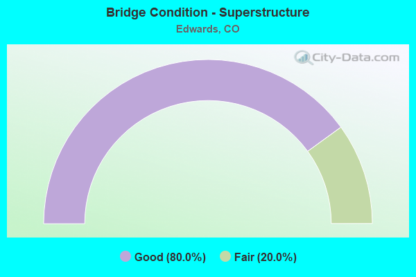
- Bridge Condition - Superstructure
- 80.0%Good
- 20.0%Fair
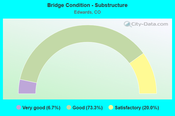
- Bridge Condition - Substructure
- 6.7%Very good
- 73.3%Good
- 20.0%Satisfactory
Find on map >> Show street view
Structure Number: EAG-028-00.1A, Location: JUST N OF SH 6 (Lat: 39.654444, Lng: -106.628889), Route carried "on" structure: County highway , Year Built: 1981, Year Reconstructed: 1993, Status: Open, Structure Length: 3.60m (11.81ft), Average Daily Traffic: 3,280 (year 2020), Truck Traffic: 4%, Average Future Daily Traffic: 4,067 (year 2040), Design Load: HS 20, Features Intersected: EAGLE RIVER, Facility Carried by Structure: CR 28-HILLCREST DR
Minimum Vertical Clearance: 30+ m (98+ ft), Kilometerpoint: 0.073, Lanes on structure: 2, Owner: County Highway Agency, Approaching Roadway Width: 8.5m (27.9ft), Material/Design: Prestressed concrete, Design/Construction: Stringer/Multi-beam, Number Of Spans In Main Unit: 1, Length of Maximum Span: 34.7m (113.8ft), Curb or Sidewalk Widths: Left: 0.0m, Right: 1.8m (5.9ft), Curb-To-Curb Width: 8.6m (28.2ft), Out-to-Out Width: 11.0m (36.1ft)
Condition: Deck: Good, Superstructure: Good, Substructure: Good, Channel: Very good, Operating Rating: 82.8 metric tons, Method Used To Determine Operating Rating: Load Factor (LF), Inventory Rating: 32.9 metric tons, Method Used To Determine Inventory Rating: Load Factor (LF), Structural Evaluation: Better than present minimum criteria, Deck Geometry: Meets minimum limits, Waterway Adequacy: Equal to present desirable criteria, Approach Roadway Alignment: Equal to present desirable criteria, Designated Inspection Frequency: Every 24 months, Inspection Date: June 2020, Deck Structure Type: Concrete Cast-file-Place, Wearing Surface/Protective System: Wearing Surface: Bituminous
Find on map >> Show street view
Structure Number: EAG-25A-00.2, Location: 0.2 MI W OF LAKE CREEK RD (Lat: 39.623056, Lng: -106.616111), Route carried "on" structure: County highway , Year Built: 1940, Year Reconstructed: 1990, Status: Open, Structure Length: 0.98m (3.22ft), Average Daily Traffic: 1,102 (year 2021), Truck Traffic: 2%, Average Future Daily Traffic: 1,366 (year 2041), Features Intersected: EAST LAKE CREEK, Facility Carried by Structure: W LAKE CREEK RD
Minimum Vertical Clearance: 30+ m (98+ ft), Kilometerpoint: 5.095, Lanes on structure: 2, Owner: County Highway Agency, Approaching Roadway Width: 7.3m (24.0ft), Material/Design: Steel, Design/Construction: Stringer/Multi-beam, Number Of Spans In Main Unit: 1, Length of Maximum Span: 9.1m (29.9ft), Curb-To-Curb Width: 8.8m (28.9ft), Out-to-Out Width: 9.7m (31.8ft)
Condition: Deck: Poor, Superstructure: Fair, Substructure: Satisfactory, Channel: Very good, Operating Rating: 37.8 metric tons, Method Used To Determine Operating Rating: Load Factor (LF), Inventory Rating: 22.7 metric tons, Method Used To Determine Inventory Rating: Load Factor (LF), Structural Evaluation: Somewhat better than minimum adequacy, Deck Geometry: Somewhat better than minimum adequacy, Waterway Adequacy: Equal to present desirable criteria, Approach Roadway Alignment: Somewhat better than minimum adequacy, Length Of Structure Improvement: 0.98m (3.22ft), Designated Inspection Frequency: Every 24 months, Inspection Date: June 2020, Bridge Improvement Cost: $65,000, Roadway Improvement Cost: $6,000, Total Project Cost: $71,000 ( Estimate for 2014), Deck Structure Type: Corrugated Steel, Wearing Surface/Protective System: Wearing Surface: Bituminous
Find on map >> Show street view
Structure Number: EAG-EDW-00.1A, Location: 0.1 MI N OF U.S 6 (Lat: 39.639444, Lng: -106.571944), Route carried "on" structure: County highway , Year Built: 2004, Status: Open, Structure Length: 4.72m (15.49ft), Average Daily Traffic: 3,887 (year 2021), Truck Traffic: 2%, Average Future Daily Traffic: 4,820 (year 2041), Design Load: HS 25 or greater, Features Intersected: EAGLE RIVER, Facility Carried by Structure: MILLER RANCH ROAD
Minimum Vertical Clearance: 30+ m (98+ ft), Kilometerpoint: 0.105, Lanes on structure: 2, Owner: County Highway Agency, Approaching Roadway Width: 13.5m (44.3ft), Material/Design: Prestressed concrete, Design/Construction: Stringer/Multi-beam, Number Of Spans In Main Unit: 1, Length of Maximum Span: 45.4m (149.0ft), Curb or Sidewalk Widths: Left: 2.7m (8.9ft), Right: 2.7m (8.9ft), Curb-To-Curb Width: 13.5m (44.3ft), Out-to-Out Width: 20.7m (67.9ft)
Condition: Deck: Good, Superstructure: Good, Substructure: Good, Channel: Very good, Operating Rating: 74.6 metric tons, Method Used To Determine Operating Rating: Load Factor (LF), Inventory Rating: 30.8 metric tons, Method Used To Determine Inventory Rating: Load Factor (LF), Structural Evaluation: Better than present minimum criteria, Deck Geometry: Superior to present desirable criteria, Waterway Adequacy: Equal to present desirable criteria, Approach Roadway Alignment: Equal to present desirable criteria, Designated Inspection Frequency: Every 24 months, Inspection Date: June 2020, Deck Structure Type: Concrete Cast-file-Place, Wearing Surface/Protective System: Wearing Surface: Bituminous, Membrane: Built-up, Deck Protection: Epoxy Coated Reinforcing
Find on map >> Show street view
Structure Number: EAG-LC1-00.1A, Location: AT W LAKE CREEK ROAD (Lat: 39.622222, Lng: -106.618056), Route carried "on" structure: County highway , Year Built: 1994, Status: Open, Structure Length: 1.00m (3.28ft), Average Daily Traffic: 249 (year 2020), Truck Traffic: 2%, Average Future Daily Traffic: 309 (year 2040), Design Load: HS 20, Features Intersected: WEST LAKE CREEK, Facility Carried by Structure: POLAR STAR ROAD
Minimum Vertical Clearance: 30+ m (98+ ft), Kilometerpoint: 0.019, Lanes on structure: 2, Owner: County Highway Agency, Approaching Roadway Width: 7.3m (24.0ft), Material/Design: Prestressed concrete, Design/Construction: Tee Beam, Number Of Spans In Main Unit: 1, Length of Maximum Span: 8.7m (28.5ft), Curb-To-Curb Width: 9.1m (29.9ft), Out-to-Out Width: 9.9m (32.5ft)
Condition: Deck: Good, Superstructure: Good, Substructure: Good, Channel: Very good, Operating Rating: 46.9 metric tons, Method Used To Determine Operating Rating: Load Factor (LF), Inventory Rating: 29.0 metric tons, Method Used To Determine Inventory Rating: Load Factor (LF), Structural Evaluation: Better than present minimum criteria, Deck Geometry: Equal to present minimum criteria, Waterway Adequacy: Equal to present desirable criteria, Approach Roadway Alignment: Equal to present minimum criteria, Designated Inspection Frequency: Every 24 months, Inspection Date: June 2020, Deck Structure Type: Other, Wearing Surface/Protective System: Wearing Surface: Bituminous
Find on map >> Show street view
Structure Number: F-10-AI, Location: .8 MI. W. OF EDWARDS (Lat: 39.647789, Lng: -106.609447), Route carried "on" structure: US 6E, Year Built: 2017, Status: Open, Structure Length: 3.12m (10.24ft), Average Daily Traffic: 8,700 (year 2020), Truck Traffic: 4%, Average Future Daily Traffic: 11,136 (year 2040), Design Load: HL 93, Features Intersected: EAST LAKE CREEK, Facility Carried by Structure: US 6 ML
Minimum Vertical Clearance: 30+ m (98+ ft), Kilometerpoint: 24.765, Lanes on structure: 2, Owner: State Highway Agency, Approaching Roadway Width: 9.4m (30.8ft), Material/Design: Prestressed concrete, Design/Construction: Stringer/Multi-beam, Number Of Spans In Main Unit: 1, Length of Maximum Span: 29.6m (97.1ft), Curb-To-Curb Width: 12.2m (40.0ft), Out-to-Out Width: 13.1m (43.0ft)
Condition: Deck: Good, Superstructure: Good, Substructure: Good, Channel: Very good, Operating Rating: 58.3 metric tons, Method Used To Determine Operating Rating: Load and Resistance Factor Rating (LRFR) rating reported by rating factor(RF) method using HL-93 loadings, Inventory Rating: 42.1 metric tons, Method Used To Determine Inventory Rating: Load and Resistance Factor Rating (LRFR) rating reported by rating factor(RF) method using HL-93 loadings, Structural Evaluation: Better than present minimum criteria, Deck Geometry: Somewhat better than minimum adequacy, Waterway Adequacy: Equal to present desirable criteria, Approach Roadway Alignment: Equal to present desirable criteria, Length Of Structure Improvement: 1.31m (4.30ft), Designated Inspection Frequency: Every 24 months, Inspection Date: August 2020, Bridge Improvement Cost: $55,000, Roadway Improvement Cost: $6,000, Total Project Cost: $83,000, Deck Structure Type: Concrete Cast-file-Place, Wearing Surface/Protective System: Wearing Surface: Bituminous
Find on map >> Show street view
Structure Number: F-10-I, Location: AT EDWARDS (Lat: 39.647567, Lng: -106.589983), Route carried "on" structure: Spur State highway 70G, Year Built: 1970, Year Reconstructed: 2020, Status: Open, Structure Length: 4.29m (14.07ft), Average Daily Traffic: 15,000 (year 2020), Truck Traffic: 4%, Average Future Daily Traffic: 18,300 (year 2040), Design Load: HS 20+Mod, Features Intersected: UP RR, Facility Carried by Structure: I 70 (EDWARDS SPUR
Minimum Vertical Clearance: 30+ m (98+ ft), Kilometerpoint: 0.407, Lanes on structure: 4, Owner: State Highway Agency, Approaching Roadway Width: 10.7m (35.1ft), Material/Design: Steel continuous, Design/Construction: Stringer/Multi-beam, Number Of Spans In Main Unit: 3, Length of Maximum Span: 18.1m (59.4ft), Curb-To-Curb Width: 17.4m (57.1ft), Out-to-Out Width: 18.3m (60.0ft)
Condition: Deck: Very good, Superstructure: Good, Substructure: Good, Operating Rating: 48.1 metric tons, Method Used To Determine Operating Rating: Load Factor (LF), Inventory Rating: 29.0 metric tons, Method Used To Determine Inventory Rating: Load Factor (LF), Structural Evaluation: Better than present minimum criteria, Deck Geometry: Somewhat better than minimum adequacy, Underclear: Superior to present desirable criteria, Approach Roadway Alignment: Equal to present desirable criteria, Designated Inspection Frequency: Every 24 months, Inspection Date: August 2020, Deck Structure Type: Concrete Cast-file-Place, Wearing Surface/Protective System: Wearing Surface: Bituminous, Membrane: Epoxy
Find on map >> Show street view
Structure Number: F-10-L, Location: 2.3 MI E OF JCT SH 131 (Lat: 39.674331, Lng: -106.647358), Route carried "on" structure: Interstate 70A, Year Built: 1970, Status: Open, Structure Length: 21.40m (70.21ft), Average Daily Traffic: 13,000 (year 2020), Truck Traffic: 11%, Average Future Daily Traffic: 17,680 (year 2040), Design Load: HS 20+Mod, Features Intersected: US 6, RR, EAGLE RIVER, Facility Carried by Structure: I 70 ML EBND
Minimum Vertical Clearance: 30+ m (98+ ft), Kilometerpoint: 256.850, Lanes on structure: 2, Lanes under structure: 2, Base Highway Network: Yes, Owner: State Highway Agency, Approaching Roadway Width: 11.6m (38.1ft), Skew: 5 degrees, Material/Design: Steel continuous, Design/Construction: Stringer/Multi-beam, Number Of Spans In Main Unit: 5, Length of Maximum Span: 46.0m (150.9ft), Curb-To-Curb Width: 11.6m (38.1ft), Out-to-Out Width: 12.3m (40.4ft)
Condition: Deck: Satisfactory, Superstructure: Fair, Substructure: Good, Channel: Very good, Operating Rating: 60.6 metric tons, Method Used To Determine Operating Rating: Load Factor (LF), Inventory Rating: 36.3 metric tons, Method Used To Determine Inventory Rating: Load Factor (LF), Structural Evaluation: Somewhat better than minimum adequacy, Deck Geometry: Equal to present minimum criteria, Underclear: Somewhat better than minimum adequacy, Waterway Adequacy: Superior to present desirable criteria, Approach Roadway Alignment: Equal to present desirable criteria, Designated Inspection Frequency: Every 24 months, Inspection Date: September 2020, Deck Structure Type: Concrete Cast-file-Place, Wearing Surface/Protective System: Wearing Surface: Bituminous, Membrane: Preformed Fabric
Find on map >> Show street view
Structure Number: F-10-M, Location: 2.3 MI E JCT SH131-WOLCOT (Lat: 39.674672, Lng: -106.647231), Route carried "on" structure: Interstate 70A, Year Built: 1970, Status: Open, Structure Length: 21.46m (70.41ft), Average Daily Traffic: 13,000 (year 2020), Truck Traffic: 11%, Average Future Daily Traffic: 17,680 (year 2040), Design Load: HS 20+Mod, Features Intersected: US 6, RR, EAGLE RIVER, Facility Carried by Structure: I 70 ML WBND
Minimum Vertical Clearance: 30+ m (98+ ft), Kilometerpoint: 256.819, Lanes on structure: 2, Lanes under structure: 2, Base Highway Network: Yes, Owner: State Highway Agency, Approaching Roadway Width: 11.6m (38.1ft), Skew: 15 degrees, Material/Design: Steel continuous, Design/Construction: Stringer/Multi-beam, Number Of Spans In Main Unit: 5, Length of Maximum Span: 45.9m (150.6ft), Curb-To-Curb Width: 11.6m (38.1ft), Out-to-Out Width: 12.3m (40.4ft)
Condition: Deck: Good, Superstructure: Good, Substructure: Good, Channel: Very good, Operating Rating: 48.8 metric tons, Method Used To Determine Operating Rating: Load Factor (LF), Inventory Rating: 29.2 metric tons, Method Used To Determine Inventory Rating: Load Factor (LF), Structural Evaluation: Better than present minimum criteria, Deck Geometry: Equal to present minimum criteria, Underclear: Equal to present minimum criteria, Waterway Adequacy: Superior to present desirable criteria, Approach Roadway Alignment: Equal to present desirable criteria, Designated Inspection Frequency: Every 24 months, Inspection Date: September 2020, Deck Structure Type: Concrete Cast-file-Place, Wearing Surface/Protective System: Wearing Surface: Bituminous
Find on map >> Show street view
Structure Number: F-10-N, Location: W. END OF EDWARDS (Lat: 39.656017, Lng: -106.628758), Route carried "on" structure: Interstate 70A, Year Built: 1970, Status: Open, Structure Length: 3.08m (10.10ft), Average Daily Traffic: 13,000 (year 2020), Truck Traffic: 11%, Average Future Daily Traffic: 17,680 (year 2040), Design Load: HS 20+Mod, Features Intersected: COUNTY ROAD, Facility Carried by Structure: I 70 ML WBND
Minimum Vertical Clearance: 30+ m (98+ ft), Kilometerpoint: 259.597, Lanes on structure: 2, Lanes under structure: 2, Base Highway Network: Yes, Owner: State Highway Agency, Approaching Roadway Width: 11.6m (38.1ft), Skew: 10 degrees, Material/Design: Concrete continuous, Design/Construction: Tee Beam, Number Of Spans In Main Unit: 3, Length of Maximum Span: 11.9m (39.0ft), Curb-To-Curb Width: 12.0m (39.4ft), Out-to-Out Width: 12.8m (42.0ft)
Condition: Deck: Satisfactory, Superstructure: Good, Substructure: Satisfactory, Operating Rating: 49.0 metric tons, Method Used To Determine Operating Rating: Load Factor (LF), Inventory Rating: 29.0 metric tons, Method Used To Determine Inventory Rating: Load Factor (LF), Structural Evaluation: Equal to present minimum criteria, Deck Geometry: Equal to present minimum criteria, Underclear: Meets minimum limits, Approach Roadway Alignment: Equal to present desirable criteria, Designated Inspection Frequency: Every 24 months, Inspection Date: August 2020, Deck Structure Type: Concrete Cast-file-Place, Wearing Surface/Protective System: Wearing Surface: Bituminous, Membrane: Built-up
Find on map >> Show street view
Structure Number: F-10-O, Location: W. END of EDWARDS (Lat: 39.655803, Lng: -106.628792), Route carried "on" structure: Interstate 70A, Year Built: 1970, Status: Open, Structure Length: 3.08m (10.10ft), Average Daily Traffic: 13,000 (year 2020), Truck Traffic: 11%, Average Future Daily Traffic: 17,680 (year 2040), Design Load: HS 20+Mod, Features Intersected: COUNTY ROAD, Facility Carried by Structure: I 70 ML EBND
Minimum Vertical Clearance: 30+ m (98+ ft), Kilometerpoint: 259.598, Lanes on structure: 2, Lanes under structure: 2, Base Highway Network: Yes, Owner: State Highway Agency, Approaching Roadway Width: 12.2m (40.0ft), Skew: 10 degrees, Material/Design: Concrete continuous, Design/Construction: Tee Beam, Number Of Spans In Main Unit: 3, Length of Maximum Span: 11.9m (39.0ft), Curb-To-Curb Width: 12.0m (39.4ft), Out-to-Out Width: 12.8m (42.0ft)
Condition: Deck: Satisfactory, Superstructure: Good, Substructure: Good, Operating Rating: 56.2 metric tons, Method Used To Determine Operating Rating: Load Factor (LF), Inventory Rating: 33.6 metric tons, Method Used To Determine Inventory Rating: Load Factor (LF), Structural Evaluation: Better than present minimum criteria, Deck Geometry: Equal to present minimum criteria, Underclear: Meets minimum limits, Approach Roadway Alignment: Equal to present desirable criteria, Designated Inspection Frequency: Every 24 months, Inspection Date: August 2020, Deck Structure Type: Concrete Cast-file-Place, Wearing Surface/Protective System: Wearing Surface: Bituminous
Find on map >> Show street view
Structure Number: F-10-P, Location: EDWARDS INTERCHANGE (Lat: 39.649525, Lng: -106.587711), Route carried "on" structure: Interstate 70A, Year Built: 1970, Status: Posted for load, Structure Length: 4.39m (14.40ft), Average Daily Traffic: 13,000 (year 2020), Truck Traffic: 11%, Average Future Daily Traffic: 17,680 (year 2040), Design Load: HS 20+Mod, Features Intersected: I 70 BUSS RT, Facility Carried by Structure: I 70 ML WBND
Minimum Vertical Clearance: 30+ m (98+ ft), Kilometerpoint: 263.292, Lanes on structure: 2, Lanes under structure: 4, Base Highway Network: Yes, Owner: State Highway Agency, Approaching Roadway Width: 11.6m (38.1ft), Skew: 10 degrees, Material/Design: Concrete continuous, Design/Construction: Tee Beam, Number Of Spans In Main Unit: 3, Length of Maximum Span: 17.7m (58.1ft), Curb-To-Curb Width: 12.8m (42.0ft), Out-to-Out Width: 13.6m (44.6ft)
Condition: Deck: Satisfactory, Superstructure: Good, Substructure: Satisfactory, Operating Rating: 49.9 metric tons, Method Used To Determine Operating Rating: Load Factor (LF), Inventory Rating: 29.9 metric tons, Method Used To Determine Inventory Rating: Load Factor (LF), Structural Evaluation: Equal to present minimum criteria, Deck Geometry: Equal to present desirable criteria, Underclear: High priority of corrective action, Approach Roadway Alignment: Equal to present desirable criteria, Designated Inspection Frequency: Every 24 months, Inspection Date: August 2020, Deck Structure Type: Concrete Cast-file-Place, Wearing Surface/Protective System: Wearing Surface: Bituminous
Find on map >> Show street view
Structure Number: F-10-QA, Location: IN EDWARDS (Lat: 39.646083, Lng: -106.592125), Route carried "on" structure: Spur State highway 70G, Year Built: 2019, Status: Open, Structure Length: 4.68m (15.35ft), Average Daily Traffic: 7,600 (year 2019), Truck Traffic: 5%, Average Future Daily Traffic: 8,360 (year 2039), Design Load: HL 93, Features Intersected: EAGLE RIVER, Facility Carried by Structure: I70(EDWARDS SPUR)
Minimum Vertical Clearance: 30+ m (98+ ft), Kilometerpoint: 0.671, Lanes on structure: 4, Owner: State Highway Agency, Approaching Roadway Width: 17.4m (57.1ft), Material/Design: Prestressed concrete, Design/Construction: Stringer/Multi-beam, Number Of Spans In Main Unit: 1, Length of Maximum Span: 45.3m (148.6ft), Curb-To-Curb Width: 17.4m (57.1ft), Out-to-Out Width: 18.3m (60.0ft)
Condition: Deck: Good, Superstructure: Good, Substructure: Very good, Channel: Very good, Operating Rating: 68.0 metric tons, Method Used To Determine Operating Rating: Load and Resistance Factor Rating (LRFR) rating reported by rating factor(RF) method using HL-93 loadings, Inventory Rating: 35.6 metric tons, Method Used To Determine Inventory Rating: Load and Resistance Factor Rating (LRFR) rating reported by rating factor(RF) method using HL-93 loadings, Structural Evaluation: Better than present minimum criteria, Deck Geometry: Somewhat better than minimum adequacy, Waterway Adequacy: Equal to present desirable criteria, Approach Roadway Alignment: Equal to present desirable criteria, Designated Inspection Frequency: Every 24 months, Inspection Date: August 2020, Deck Structure Type: Concrete Cast-file-Place, Wearing Surface/Protective System: Wearing Surface: Bituminous, Membrane: Epoxy
Find on map >> Show street view
Structure Number: F-10-R, Location: EDWARDS INTERCHANGE (Lat: 39.649317, Lng: -106.587803), Route carried "on" structure: Interstate 70A, Year Built: 1970, Status: Open, Structure Length: 4.39m (14.40ft), Average Daily Traffic: 13,000 (year 2020), Truck Traffic: 11%, Average Future Daily Traffic: 17,680 (year 2040), Design Load: HS 20+Mod, Features Intersected: I 70 BUSS RT, Facility Carried by Structure: I 70 ML EBND
Minimum Vertical Clearance: 30+ m (98+ ft), Kilometerpoint: 263.294, Lanes on structure: 2, Lanes under structure: 4, Base Highway Network: Yes, Owner: State Highway Agency, Approaching Roadway Width: 11.6m (38.1ft), Skew: 10 degrees, Material/Design: Concrete continuous, Design/Construction: Tee Beam, Number Of Spans In Main Unit: 3, Length of Maximum Span: 17.7m (58.1ft), Curb-To-Curb Width: 12.8m (42.0ft), Out-to-Out Width: 13.6m (44.6ft)
Condition: Deck: Satisfactory, Superstructure: Fair, Substructure: Good, Operating Rating: 49.9 metric tons, Method Used To Determine Operating Rating: Load Factor (LF), Inventory Rating: 29.9 metric tons, Method Used To Determine Inventory Rating: Load Factor (LF), Structural Evaluation: Somewhat better than minimum adequacy, Deck Geometry: Equal to present desirable criteria, Underclear: High priority of corrective action, Approach Roadway Alignment: Equal to present desirable criteria, Designated Inspection Frequency: Every 24 months, Inspection Date: August 2020, Deck Structure Type: Concrete Cast-file-Place, Wearing Surface/Protective System: Wearing Surface: Bituminous, Membrane: Epoxy
Find on map >> Show street view
Structure Number: F-10-Y, Location: 1 MI. E. OF EDWARDS (Lat: 39.643469, Lng: -106.574253), Route carried "on" structure: Interstate 70A, Year Built: 1971, Status: Open, Structure Length: 2.26m (7.41ft), Average Daily Traffic: 17,000 (year 2020), Truck Traffic: 8%, Average Future Daily Traffic: 22,440 (year 2040), Design Load: HS 20+Mod, Features Intersected: WINSLOW ROAD, Facility Carried by Structure: I 70 ML WBND
Minimum Vertical Clearance: 30+ m (98+ ft), Kilometerpoint: 264.669, Lanes on structure: 2, Lanes under structure: 2, Base Highway Network: Yes, Owner: State Highway Agency, Approaching Roadway Width: 11.6m (38.1ft), Skew: 10 degrees, Material/Design: Prestressed concrete, Design/Construction: Stringer/Multi-beam, Number Of Spans In Main Unit: 1, Length of Maximum Span: 21.9m (71.9ft), Curb-To-Curb Width: 12.0m (39.4ft), Out-to-Out Width: 12.8m (42.0ft)
Condition: Deck: Satisfactory, Superstructure: Good, Substructure: Good, Operating Rating: 67.9 metric tons, Method Used To Determine Operating Rating: Load Factor (LF), Inventory Rating: 35.1 metric tons, Method Used To Determine Inventory Rating: Load Factor (LF), Structural Evaluation: Better than present minimum criteria, Deck Geometry: Equal to present minimum criteria, Underclear: High priority of corrective action, Approach Roadway Alignment: Equal to present desirable criteria, Designated Inspection Frequency: Every 24 months, Inspection Date: August 2020, Deck Structure Type: Concrete Cast-file-Place, Wearing Surface/Protective System: Wearing Surface: Bituminous, Membrane: Built-up
Find on map >> Show street view
Structure Number: F-10-Z, Location: 1 MI. E. OF EDWARDS (Lat: 39.643125, Lng: -106.574369), Route carried "on" structure: Interstate 70A, Year Built: 1971, Status: Open, Structure Length: 2.27m (7.45ft), Average Daily Traffic: 17,000 (year 2020), Truck Traffic: 8%, Average Future Daily Traffic: 22,440 (year 2040), Design Load: HS 20+Mod, Features Intersected: WINSLOW ROAD, Facility Carried by Structure: I 70 ML EBND
Minimum Vertical Clearance: 30+ m (98+ ft), Kilometerpoint: 264.673, Lanes on structure: 2, Lanes under structure: 2, Base Highway Network: Yes, Owner: State Highway Agency, Approaching Roadway Width: 11.6m (38.1ft), Skew: 10 degrees, Material/Design: Prestressed concrete, Design/Construction: Stringer/Multi-beam, Number Of Spans In Main Unit: 1, Length of Maximum Span: 21.9m (71.9ft), Curb-To-Curb Width: 12.0m (39.4ft), Out-to-Out Width: 12.8m (42.0ft)
Condition: Deck: Good, Superstructure: Good, Substructure: Good, Operating Rating: 71.6 metric tons, Method Used To Determine Operating Rating: Load Factor (LF), Inventory Rating: 41.9 metric tons, Method Used To Determine Inventory Rating: Load Factor (LF), Structural Evaluation: Better than present minimum criteria, Deck Geometry: Equal to present minimum criteria, Underclear: High priority of corrective action, Approach Roadway Alignment: Equal to present desirable criteria, Designated Inspection Frequency: Every 24 months, Inspection Date: August 2020, Deck Structure Type: Concrete Cast-file-Place, Wearing Surface/Protective System: Wearing Surface: Bituminous
Find on map >> Show street view
Structure Number: F-10-L, Location: 2.3 MI E OF JCT SH 131 (Lat: 39.674331, Lng: -106.647358), Route carried "under" structure: US 6E, Year Built: 1970, Structure Length: 0. m, Average Daily Traffic: 3,100 (year 2011), Truck Traffic: 6%, Features Intersected: US 6, RR, EAGLE RIVER, Facility Carried by Structure: I 70 ML EBND
Minimum Vertical Clearance: 6.38m (20.93ft), Kilometerpoint: 260.839, Lanes on structure: 2, Lanes under structure: 2, Material/Design: Steel continuous, Design/Construction: Stringer/Multi-beam, Length of Maximum Span: 46.0m (150.9ft)
Find on map >> Show street view
Structure Number: F-10-M, Location: 2.3 MI E JCT SH131-WOLCOT (Lat: 39.674672, Lng: -106.647231), Route carried "under" structure: US 6E, Year Built: 1970, Structure Length: 0. m, Average Daily Traffic: 3,100 (year 2011), Truck Traffic: 6%, Features Intersected: US 6, RR, EAGLE RIVER, Facility Carried by Structure: I 70 ML WBND
Minimum Vertical Clearance: 5.74m (18.83ft), Kilometerpoint: 260.839, Lanes on structure: 2, Lanes under structure: 2, Material/Design: Steel continuous, Design/Construction: Stringer/Multi-beam, Length of Maximum Span: 45.9m (150.6ft)
Find on map >> Show street view
Structure Number: F-10-P, Location: EDWARDS INTERCHANGE (Lat: 39.649525, Lng: -106.587711), Route carried "under" structure: Business State highway 70G, Year Built: 1970, Structure Length: 0. m, Average Daily Traffic: 6,100 (year 2011), Truck Traffic: 5%, Features Intersected: I 70 BUSS RT, Facility Carried by Structure: I 70 ML WBND
Minimum Vertical Clearance: 5.41m (17.75ft), Kilometerpoint: 0.002, Lanes on structure: 2, Lanes under structure: 3, Material/Design: Concrete continuous, Design/Construction: Tee Beam, Length of Maximum Span: 17.7m (58.1ft)
Find on map >> Show street view
Structure Number: F-10-R, Location: EDWARDS INTERCHANGE (Lat: 39.649317, Lng: -106.587803), Route carried "under" structure: Business State highway 70G, Year Built: 1970, Structure Length: 0. m, Average Daily Traffic: 6,100 (year 2011), Truck Traffic: 5%, Features Intersected: I 70 BUSS RT, Facility Carried by Structure: I 70 ML EBND
Minimum Vertical Clearance: 5.18m (16.99ft), Kilometerpoint: 0.003, Lanes on structure: 2, Lanes under structure: 2, Material/Design: Concrete continuous, Design/Construction: Tee Beam, Length of Maximum Span: 17.7m (58.1ft)