Bridge Statistics for Edenborn, Pennsylvania (PA)
Condition, Traffic, Stress, Structural Evaluation, Project Costs
- National Bridge Inventory (NBI) Statistics
- 11Number of bridges
- 43ft / 13.1mTotal length
- $741,000Total costs
- 3,836Total average daily traffic
- 266Total average daily truck traffic
- 4,796Total future (year 2012) average daily traffic
- National Bridge Inventory (NBI) Registered Bridges for Edenborn
- No street view available for this location
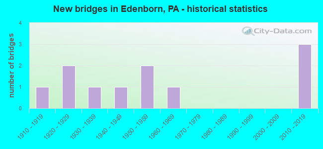
- New bridges - historical statistics
- 11910-1919
- 21920-1929
- 11930-1939
- 11940-1949
- 21950-1959
- 11960-1969
- 32010-2019

- Reconstructed bridges - Historical Statistics
- 11990-1999
- 02000-2009
- 22010-2019

- Bridge Condition - Deck
- 11.1%Excellent
- 33.3%Very good
- 55.6%Fair

- Bridge Condition - Superstructure
- 22.2%Excellent
- 22.2%Very good
- 44.4%Fair
- 11.1%Serious

- Bridge Condition - Substructure
- 11.1%Excellent
- 11.1%Very good
- 11.1%Good
- 22.2%Satisfactory
- 44.4%Fair

- Bridge Condition - Channel
- 9.1%Very good
- 36.4%Good
- 18.2%Satisfactory
- 27.3%Fair
- 9.1%Poor

- Bridge Condition - Culverts
- 50.0%Very good
- 50.0%Fair
Find on map >> Show street view
Structure Number: 16912, Location: GERMAN TOWNSHIP (Lat: 39.863714, Lng: -79.871192), Route carried "on" structure: State highway , Year Built: 1953, Status: Open, Structure Length: 1.31m (4.30ft), Average Daily Traffic: 1,648 (year 2022), Truck Traffic: 8%, Average Future Daily Traffic: 1,755 (year 2032), Design Load: H 20, Features Intersected: NORTH BRANCH BROWNS RUN, Facility Carried by Structure: SR 3012
Minimum Vertical Clearance: 30+ m (98+ ft), Kilometerpoint: 1.883, Lanes on structure: 2, Owner: State Highway Agency, Approaching Roadway Width: 6.1m (20.0ft), Skew: 1 degrees, Material/Design: Steel, Design/Construction: Stringer/Multi-beam, Number Of Spans In Main Unit: 1, Length of Maximum Span: 12.8m (42.0ft), Curb-To-Curb Width: 7.3m (24.0ft), Out-to-Out Width: 8.2m (26.9ft)
Condition: Deck: Fair, Superstructure: Fair, Substructure: Fair, Channel: Satisfactory, Operating Rating: 49.9 metric tons, Method Used To Determine Operating Rating: Load Factor (LF), Inventory Rating: 29.9 metric tons, Method Used To Determine Inventory Rating: Load Factor (LF), Structural Evaluation: Somewhat better than minimum adequacy, Deck Geometry: Meets minimum limits, Waterway Adequacy: Superior to present desirable criteria, Approach Roadway Alignment: Better than present minimum criteria, Length Of Structure Improvement: 2.00m (6.56ft), Designated Inspection Frequency: Every 24 months, Inspection Date: Febuary 2021, Deck Structure Type: Closed Grating, Wearing Surface/Protective System: Wearing Surface: Bituminous
Find on map >> Show street view
Structure Number: 16916, Location: GERMAN TOWNSHIP (Lat: 39.874717, Lng: -79.859861), Route carried "on" structure: State highway , Year Built: 1916, Year Reconstructed: 2019, Status: Open, Structure Length: 1.10m (3.61ft), Average Daily Traffic: 521 (year 2022), Truck Traffic: 9%, Average Future Daily Traffic: 830 (year 2032), Design Load: HL 93, Features Intersected: NORTH BRANCH BROWNS RUN, Facility Carried by Structure: SR 3013
Minimum Vertical Clearance: 30+ m (98+ ft), Kilometerpoint: 5.267, Lanes on structure: 2, Owner: State Highway Agency, Approaching Roadway Width: 5.8m (19.0ft), Skew: 3 degrees, Material/Design: Prestressed concrete, Design/Construction: Box Beam or Girders - Single/Spread, Number Of Spans In Main Unit: 1, Length of Maximum Span: 10.7m (35.1ft), Curb-To-Curb Width: 5.8m (19.0ft), Out-to-Out Width: 8.1m (26.6ft)
Condition: Deck: Very good, Superstructure: Very good, Substructure: Good, Channel: Good, Operating Rating: 46.0 metric tons, Method Used To Determine Operating Rating: Assigned ratings based on Load and Resistance Factor Design (LRFD) reported by rating factor (RF) using HL93 loadings, Inventory Rating: 35.3 metric tons, Method Used To Determine Inventory Rating: Assigned ratings based on Load and Resistance Factor Design (LRFD) reported by rating factor (RF) using HL93 loadings, Structural Evaluation: Better than present minimum criteria, Deck Geometry: High priority of replacement, Waterway Adequacy: Equal to present desirable criteria, Approach Roadway Alignment: Equal to present minimum criteria, Length Of Structure Improvement: 1.10m (3.61ft), Designated Inspection Frequency: Every 24 months, Inspection Date: Febuary 2021, Bridge Improvement Cost: $23,000, Roadway Improvement Cost: $66,000, Total Project Cost: $305,000, Deck Structure Type: Concrete Cast-file-Place, Wearing Surface/Protective System: Wearing Surface: Monolithic Concrete, Deck Protection: Epoxy Coated Reinforcing
Find on map >> Show street view
Structure Number: 16919, Location: GERMAN TOWNSHIP (Lat: 39.904508, Lng: -79.890403), Route carried "on" structure: State highway , Year Built: 1962, Status: Open, Structure Length: 0.79m (2.59ft), Average Daily Traffic: 287 (year 2022), Truck Traffic: 9%, Average Future Daily Traffic: 140 (year 2032), Design Load: HS 20, Features Intersected: MIDDLE RUN, Facility Carried by Structure: SR 3013
Minimum Vertical Clearance: 30+ m (98+ ft), Kilometerpoint: 11.584, Lanes on structure: 2, Owner: State Highway Agency, Approaching Roadway Width: 11.0m (36.1ft), Skew: 6 degrees, Material/Design: Steel, Design/Construction: Culvert, Number Of Spans In Main Unit: 1, Length of Maximum Span: 7.9m (25.9ft)
Condition: Channel: Fair, Culverts: Fair, Inventory Rating: 99.8 metric tons, Method Used To Determine Inventory Rating: Load Factor (LF), Structural Evaluation: Somewhat better than minimum adequacy, Waterway Adequacy: Superior to present desirable criteria, Approach Roadway Alignment: Equal to present desirable criteria, Length Of Structure Improvement: 1.50m (4.92ft), Designated Inspection Frequency: Every 24 months, Inspection Date: Febuary 2021, Bridge Improvement Cost: $9,000, Roadway Improvement Cost: $25,000, Total Project Cost: $117,000
Find on map >> Show street view
Structure Number: 17089, Location: 575 FT WEST OF COLLEGE AV (Lat: 39.883883, Lng: -79.872953), Route carried "on" structure: City street T337, Year Built: 1940, Status: Open, Structure Length: 0.94m (3.08ft), Average Daily Traffic: 500 (year 2012), Average Future Daily Traffic: 700 (year 2032), Design Load: H 20, Features Intersected: N BR BROWNS RUN TRIB
Minimum Vertical Clearance: 30+ m (98+ ft), Kilometerpoint: 0.000, Lanes on structure: 2, Owner: Town or Township Highway Agency, Approaching Roadway Width: 6.4m (21.0ft), Skew: 1 degrees, Material/Design: Steel, Design/Construction: Stringer/Multi-beam, Number Of Spans In Main Unit: 1, Length of Maximum Span: 8.8m (28.9ft), Curb or Sidewalk Widths: Left: 1.3m (4.3ft), Right: 0.0m, Curb-To-Curb Width: 7.9m (25.9ft), Out-to-Out Width: 10.2m (33.5ft)
Condition: Deck: Fair, Superstructure: Fair, Substructure: Satisfactory, Channel: Poor, Operating Rating: 56.2 metric tons, Method Used To Determine Operating Rating: Load Factor (LF), Inventory Rating: 33.6 metric tons, Method Used To Determine Inventory Rating: Load Factor (LF), Structural Evaluation: Somewhat better than minimum adequacy, Deck Geometry: Somewhat better than minimum adequacy, Waterway Adequacy: Equal to present desirable criteria, Approach Roadway Alignment: Equal to present desirable criteria, Length Of Structure Improvement: 1.60m (5.25ft), Designated Inspection Frequency: Every 24 months, Inspection Date: March 2020, Bridge Improvement Cost: $10,000, Roadway Improvement Cost: $30,000, Total Project Cost: $137,000, Deck Structure Type: Concrete Cast-file-Place, Wearing Surface/Protective System: Wearing Surface: Bituminous
Find on map >> Show street view
Structure Number: 1709, Location: 250 FT EAST OF DEMNIAK RD (Lat: 39.867703, Lng: -79.869131), Route carried "on" structure: City street T464, Year Built: 1929, Year Reconstructed: 2002, Status: Open, Structure Length: 0.76m (2.49ft), Average Daily Traffic: 25 (year 2012), Average Future Daily Traffic: 30 (year 2032), Design Load: HL 93, Features Intersected: NORTH BR BROWNS RUN, Facility Carried by Structure: T-464 PLUMMER RD
Minimum Vertical Clearance: 30+ m (98+ ft), Kilometerpoint: 0.000, Lanes on structure: 1, Owner: Town or Township Highway Agency, Approaching Roadway Width: 4.3m (14.1ft), Material/Design: Steel, Design/Construction: Stringer/Multi-beam, Number Of Spans In Main Unit: 1, Length of Maximum Span: 7.0m (23.0ft), Curb-To-Curb Width: 4.7m (15.4ft), Out-to-Out Width: 4.9m (16.1ft)
Condition: Deck: Fair, Superstructure: Fair, Substructure: Fair, Channel: Fair, Operating Rating: 86.2 metric tons, Method Used To Determine Operating Rating: Load Factor (LF), Inventory Rating: 51.7 metric tons, Method Used To Determine Inventory Rating: Load Factor (LF), Structural Evaluation: Somewhat better than minimum adequacy, Deck Geometry: Better than present minimum criteria, Waterway Adequacy: Equal to present minimum criteria, Approach Roadway Alignment: Meets minimum limits, Length Of Structure Improvement: 1.40m (4.59ft), Designated Inspection Frequency: Every 24 months, Inspection Date: March 2020, Bridge Improvement Cost: $5,000, Roadway Improvement Cost: $15,000, Total Project Cost: $69,000, Deck Structure Type: Concrete Cast-file-Place, Wearing Surface/Protective System: Wearing Surface: Bituminous, Deck Protection: Other
Find on map >> Show street view
Structure Number: 17091, Location: AT SR 166 INTERSECTION (Lat: 39.900028, Lng: -79.893708), Route carried "on" structure: City street T379, Year Built: 1930, Year Reconstructed: 2018, Status: Open, Structure Length: 0.73m (2.40ft), Average Daily Traffic: 50 (year 2012), Average Future Daily Traffic: 60 (year 2032), Design Load: H 15, Features Intersected: MIDDLE RUN, Facility Carried by Structure: T-379 COLLEGE AVE
Minimum Vertical Clearance: 30+ m (98+ ft), Kilometerpoint: 0.000, Lanes on structure: 2, Owner: Town or Township Highway Agency, Approaching Roadway Width: 4.6m (15.1ft), Material/Design: Steel, Design/Construction: Stringer/Multi-beam, Number Of Spans In Main Unit: 1, Length of Maximum Span: 7.0m (23.0ft), Curb-To-Curb Width: 10.8m (35.4ft), Out-to-Out Width: 11.7m (38.4ft)
Condition: Deck: Very good, Superstructure: Very good, Substructure: Satisfactory, Channel: Satisfactory, Operating Rating: 52.6 metric tons, Method Used To Determine Operating Rating: Load Factor (LF), Inventory Rating: 31.8 metric tons, Method Used To Determine Inventory Rating: Load Factor (LF), Structural Evaluation: Equal to present minimum criteria, Deck Geometry: Superior to present desirable criteria, Waterway Adequacy: Equal to present minimum criteria, Approach Roadway Alignment: Equal to present desirable criteria, Length Of Structure Improvement: 0.70m (2.30ft), Designated Inspection Frequency: Every 24 months, Inspection Date: March 2020, Bridge Improvement Cost: $3,000, Roadway Improvement Cost: $12,000, Total Project Cost: $38,000, Deck Structure Type: Concrete Cast-file-Place, Wearing Surface/Protective System: Wearing Surface: Bituminous
Find on map >> Show street view
Structure Number: 17093, Location: 100' S of SR3012 (Lat: 39.866522, Lng: -79.883100), Route carried "on" structure: City street T439, Year Built: 1920, Status: Posted for load, Structure Length: 1.40m (4.59ft), Average Daily Traffic: 50 (year 2006), Truck Traffic: 5%, Average Future Daily Traffic: 140 (year 2012), Design Load: H 10, Features Intersected: Browns Run, Facility Carried by Structure: Yuras Farm Road
Minimum Vertical Clearance: 30+ m (98+ ft), Kilometerpoint: 0.000, Lanes on structure: 1, Owner: County Highway Agency, Approaching Roadway Width: 3.7m (12.1ft), Material/Design: Steel, Design/Construction: Truss - Thru, Number Of Spans In Main Unit: 1, Length of Maximum Span: 13.1m (43.0ft), Curb or Sidewalk Widths: Left: 0.2m (0.7ft), Right: 0.2m (0.7ft), Curb-To-Curb Width: 3.5m (11.5ft), Out-to-Out Width: 3.8m (12.5ft)
Condition: Deck: Fair, Superstructure: Serious, Substructure: Fair, Channel: Good, Operating Rating: 3.6 metric tons, Method Used To Determine Operating Rating: Field evaluation and documented engineering judgment, Inventory Rating: 2.7 metric tons, Method Used To Determine Inventory Rating: Field evaluation and documented engineering judgment, Structural Evaluation: High priority of corrective action, Deck Geometry: High priority of corrective action, Waterway Adequacy: Better than present minimum criteria, Approach Roadway Alignment: Equal to present minimum criteria, Bridge Posting: Required (Relationship of Operating Rating to Maximum Legal Load: > 39.9% below), Length Of Structure Improvement: 2.00m (6.56ft), Designated Inspection Frequency: Every 24 months, Critical Feature Inspection Frequency: Every 6 months, Other Special Inspection Frequency: Every 6 months, Inspection Date: September 2021, Critical Feature Inspection Date: September 2021, Other Special Inspection Date: September 2021, Bridge Improvement Cost: $6,000, Roadway Improvement Cost: $16,000, Total Project Cost: $75,000, Deck Structure Type: Wood or Timber
Find on map >> Show street view
Structure Number: 4827, Location: German Township (Lat: 39.876217, Lng: -79.843336), Route carried "on" structure: City street 456, Year Built: 1955, Status: Open, Structure Length: 0.98m (3.22ft), Average Daily Traffic: 50 (year 2013), Truck Traffic: 3%, Average Future Daily Traffic: 55 (year 2033), Design Load: HS 20, Features Intersected: N. Br of Browns Run
Minimum Vertical Clearance: 30+ m (98+ ft), Kilometerpoint: 0.000, Lanes on structure: 2, Toll: Toll bridge, Owner: Town or Township Highway Agency, Approaching Roadway Width: 4.9m (16.1ft), Skew: 3 degrees, Material/Design: Steel, Design/Construction: Stringer/Multi-beam, Number Of Spans In Main Unit: 1, Length of Maximum Span: 8.8m (28.9ft), Curb or Sidewalk Widths: Left: 0.1m (0.3ft), Right: 0.1m (0.3ft), Curb-To-Curb Width: 5.0m (16.4ft), Out-to-Out Width: 5.5m (18.0ft)
Condition: Deck: Fair, Superstructure: Fair, Substructure: Fair, Channel: Fair, Operating Rating: 89.8 metric tons, Method Used To Determine Operating Rating: Load Factor (LF), Inventory Rating: 53.5 metric tons, Method Used To Determine Inventory Rating: Load Factor (LF), Structural Evaluation: Somewhat better than minimum adequacy, Deck Geometry: High priority of corrective action, Waterway Adequacy: Better than present minimum criteria, Approach Roadway Alignment: Better than present minimum criteria, Designated Inspection Frequency: Every 24 months, Inspection Date: March 2020, Wearing Surface/Protective System: Wearing Surface: Bituminous, Deck Protection: Other
Find on map >> Show street view
Structure Number: 538, Location: GERMAN TOWNSHIP (Lat: 39.901639, Lng: -79.893703), Route carried "on" structure: State highway , Year Built: 2018, Status: Open, Structure Length: 1.01m (3.31ft), Average Daily Traffic: 287 (year 2022), Truck Traffic: 9%, Average Future Daily Traffic: 140 (year 2032), Design Load: HL 93, Features Intersected: MIDDLE RUN, Facility Carried by Structure: Riffle Hollow Rd
Minimum Vertical Clearance: 30+ m (98+ ft), Kilometerpoint: 11.584, Lanes on structure: 2, Owner: State Highway Agency, Maintenance Responsibility: Private, Approaching Roadway Width: 6.1m (20.0ft), Skew: 3 degrees, Material/Design: Concrete, Design/Construction: Culvert, Number Of Spans In Main Unit: 1, Length of Maximum Span: 9.1m (29.9ft), Curb-To-Curb Width: 7.7m (25.3ft), Out-to-Out Width: 15.8m (51.8ft)
Condition: Channel: Good, Culverts: Very good, Operating Rating: 61.2 metric tons, Method Used To Determine Operating Rating: Assigned ratings based on Load and Resistance Factor Design (LRFD) reported by rating factor (RF) using HL93 loadings, Inventory Rating: 38.6 metric tons, Method Used To Determine Inventory Rating: Assigned ratings based on Load and Resistance Factor Design (LRFD) reported by rating factor (RF) using HL93 loadings, Structural Evaluation: Equal to present desirable criteria, Deck Geometry: Somewhat better than minimum adequacy, Waterway Adequacy: Better than present minimum criteria, Approach Roadway Alignment: Equal to present desirable criteria, Designated Inspection Frequency: Every 24 months, Inspection Date: October 2021, Wearing Surface/Protective System: Wearing Surface: Bituminous, Membrane: Preformed Fabric
Find on map >> Show street view
Structure Number: 53801, Location: GERMAN TOWNSHIP (Lat: 39.899283, Lng: -79.898153), Route carried "on" structure: State highway , Year Built: 2018, Status: Open, Structure Length: 2.13m (6.99ft), Average Daily Traffic: 209 (year 2022), Truck Traffic: 9%, Average Future Daily Traffic: 473 (year 2037), Design Load: HL 93, Features Intersected: MIDDLE RUN, Facility Carried by Structure: SR 3013
Minimum Vertical Clearance: 30+ m (98+ ft), Kilometerpoint: 12.014, Lanes on structure: 2, Owner: State Highway Agency, Maintenance Responsibility: Private, Approaching Roadway Width: 6.4m (21.0ft), Skew: 4 degrees, Material/Design: Prestressed concrete, Design/Construction: Box Beam or Girders - Single/Spread, Number Of Spans In Main Unit: 1, Length of Maximum Span: 19.5m (64.0ft), Curb-To-Curb Width: 7.9m (25.9ft), Out-to-Out Width: 8.5m (27.9ft)
Condition: Deck: Excellent, Superstructure: Excellent, Substructure: Very good, Channel: Good, Operating Rating: 53.1 metric tons, Method Used To Determine Operating Rating: Assigned ratings based on Load and Resistance Factor Design (LRFD) reported by rating factor (RF) using HL93 loadings, Inventory Rating: 41.1 metric tons, Method Used To Determine Inventory Rating: Assigned ratings based on Load and Resistance Factor Design (LRFD) reported by rating factor (RF) using HL93 loadings, Structural Evaluation: Equal to present desirable criteria, Deck Geometry: Somewhat better than minimum adequacy, Waterway Adequacy: Superior to present desirable criteria, Approach Roadway Alignment: Somewhat better than minimum adequacy, Designated Inspection Frequency: Every 24 months, Inspection Date: May 2020, Deck Structure Type: Concrete Cast-file-Place, Wearing Surface/Protective System: Wearing Surface: Integral Concrete, Deck Protection: Epoxy Coated Reinforcing
Find on map >> Show street view
Structure Number: 53802, Location: GERMAN TOWNSHIP (Lat: 39.897933, Lng: -79.899947), Route carried "on" structure: State highway , Year Built: 2017, Status: Open, Structure Length: 1.95m (6.40ft), Average Daily Traffic: 209 (year 2022), Truck Traffic: 9%, Average Future Daily Traffic: 473 (year 2039), Design Load: HL 93, Features Intersected: MIDDLE RUN, Facility Carried by Structure: PALMER RD(SR 3013)
Minimum Vertical Clearance: 30+ m (98+ ft), Kilometerpoint: 12.014, Lanes on structure: 2, Owner: State Highway Agency, Maintenance Responsibility: Private, Approaching Roadway Width: 7.3m (24.0ft), Skew: 4 degrees, Material/Design: Prestressed concrete, Design/Construction: Box Beam or Girders - Single/Spread, Number Of Spans In Main Unit: 1, Length of Maximum Span: 18.0m (59.1ft), Curb-To-Curb Width: 7.4m (24.3ft), Out-to-Out Width: 8.0m (26.2ft)
Condition: Deck: Very good, Superstructure: Excellent, Substructure: Excellent, Channel: Very good, Operating Rating: 56.7 metric tons, Method Used To Determine Operating Rating: Assigned ratings based on Load and Resistance Factor Design (LRFD) reported by rating factor (RF) using HL93 loadings, Inventory Rating: 43.4 metric tons, Method Used To Determine Inventory Rating: Assigned ratings based on Load and Resistance Factor Design (LRFD) reported by rating factor (RF) using HL93 loadings, Structural Evaluation: Superior to present desirable criteria, Deck Geometry: Somewhat better than minimum adequacy, Waterway Adequacy: Superior to present desirable criteria, Approach Roadway Alignment: Somewhat better than minimum adequacy, Designated Inspection Frequency: Every 24 months, Inspection Date: May 2021, Deck Structure Type: Concrete Cast-file-Place, Wearing Surface/Protective System: Wearing Surface: Integral Concrete, Deck Protection: Epoxy Coated Reinforcing