Bridge Statistics for East Spencer, North Carolina (NC)
Condition, Traffic, Stress, Structural Evaluation, Project Costs
- National Bridge Inventory (NBI) Statistics
- 15Number of bridges
- 138ft / 42.3mTotal length
- 329,100Total average daily traffic
- 50,344Total average daily truck traffic
- National Bridge Inventory (NBI) Registered Bridges for East Spencer
- No street view available for this location
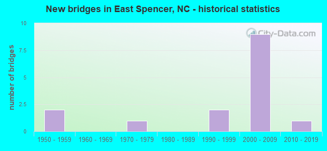
- New bridges - historical statistics
- 21950-1959
- 11970-1979
- 21990-1999
- 92000-2009
- 12010-2019


- Bridge Condition - Deck
- 28.6%Very good
- 71.4%Good

- Bridge Condition - Superstructure
- 85.7%Very good
- 14.3%Good

- Bridge Condition - Substructure
- 85.7%Good
- 14.3%Satisfactory

- Bridge Condition - Channel
- 25.0%Good
- 12.5%Satisfactory
- 62.5%Fair

- Bridge Condition - Culverts
- 50.0%Satisfactory
- 50.0%Fair
Find on map >> Show street view
Structure Number: 1590092, Location: 0.7 MI. N. JCT. SR2170 (Lat: 35.674525, Lng: -80.399064), Route carried "on" structure: State highway 1915, Year Built: 1995, Status: Open, Structure Length: 3.71m (12.17ft), Average Daily Traffic: 1,400 (year 2013), Truck Traffic: 6%, Average Future Daily Traffic: 2,800 (year 2040), Design Load: HS 20+Mod, Features Intersected: CRANE CREEK
Minimum Vertical Clearance: 30+ m (98+ ft), Kilometerpoint: 0.000, Lanes on structure: 2, Owner: State Highway Agency, Approaching Roadway Width: 7.9m (25.9ft), Skew: 2 degrees, Material/Design: Prestressed concrete, Design/Construction: Slab, Number Of Spans In Main Unit: 3, Length of Maximum Span: 11.8m (38.7ft), Curb-To-Curb Width: 8.9m (29.2ft), Out-to-Out Width: 10.0m (32.8ft)
Condition: Deck: Very good, Superstructure: Very good, Substructure: Good, Channel: Good, Operating Rating: 73.4 metric tons, Method Used To Determine Operating Rating: Load Factor (LF), Inventory Rating: 43.5 metric tons, Method Used To Determine Inventory Rating: Load Factor (LF), Structural Evaluation: Better than present minimum criteria, Deck Geometry: Somewhat better than minimum adequacy, Waterway Adequacy: Better than present minimum criteria, Approach Roadway Alignment: Equal to present desirable criteria, Designated Inspection Frequency: Every 24 months, Inspection Date: September 2020, Deck Structure Type: Concrete Precast Panels, Wearing Surface/Protective System: Wearing Surface: Bituminous, Deck Protection: Epoxy Coated Reinforcing
Find on map >> Show street view
Structure Number: 1590093, Location: 0.2 MI. E. JCT. SR2115 (Lat: 35.679789, Lng: -80.415567), Route carried "on" structure: State highway 1915, Year Built: 2006, Status: Open, Structure Length: 8.13m (26.67ft), Average Daily Traffic: 4,600 (year 2013), Truck Traffic: 7%, Average Future Daily Traffic: 9,200 (year 2040), Design Load: HS 20+Mod, Features Intersected: TOWN CREEK
Minimum Vertical Clearance: 30+ m (98+ ft), Kilometerpoint: 0.000, Lanes on structure: 3, Owner: State Highway Agency, Approaching Roadway Width: 12.8m (42.0ft), Material/Design: Prestressed concrete continuous, Design/Construction: Stringer/Multi-beam, Number Of Spans In Main Unit: 3, Length of Maximum Span: 27.1m (88.9ft), Curb or Sidewalk Widths: Left: 1.6m (5.2ft), Right: 1.6m (5.2ft), Curb-To-Curb Width: 15.8m (51.8ft), Out-to-Out Width: 19.9m (65.3ft)
Condition: Deck: Good, Superstructure: Good, Substructure: Good, Channel: Satisfactory, Operating Rating: 78.0 metric tons, Method Used To Determine Operating Rating: Load Factor (LF), Inventory Rating: 19.9 metric tons, Method Used To Determine Inventory Rating: Load Factor (LF), Structural Evaluation: Somewhat better than minimum adequacy, Deck Geometry: Better than present minimum criteria, Waterway Adequacy: Superior to present desirable criteria, Approach Roadway Alignment: Equal to present desirable criteria, Designated Inspection Frequency: Every 24 months, Inspection Date: November 2020, Deck Structure Type: Concrete Cast-file-Place, Wearing Surface/Protective System: Wearing Surface: Monolithic Concrete, Deck Protection: Epoxy Coated Reinforcing
Find on map >> Show street view
Structure Number: 1590095, Location: 0.7 MI. E. JCT. SR2100 (Lat: 35.672281, Lng: -80.433294), Route carried "on" structure: State highway 2114, Year Built: 2010, Status: Open, Structure Length: 2.68m (8.79ft), Average Daily Traffic: 1,700 (year 2012), Truck Traffic: 7%, Average Future Daily Traffic: 3,400 (year 2040), Design Load: HS 20, Features Intersected: TOWN CREEK
Minimum Vertical Clearance: 30+ m (98+ ft), Kilometerpoint: 0.000, Lanes on structure: 2, Owner: State Highway Agency, Approaching Roadway Width: 9.4m (30.8ft), Skew: 3 degrees, Material/Design: Prestressed concrete, Design/Construction: Slab, Number Of Spans In Main Unit: 2, Length of Maximum Span: 16.1m (52.8ft), Curb-To-Curb Width: 9.0m (29.5ft), Out-to-Out Width: 10.0m (32.8ft)
Condition: Deck: Very good, Superstructure: Very good, Substructure: Satisfactory, Channel: Good, Operating Rating: 89.8 metric tons, Method Used To Determine Operating Rating: Load Factor (LF), Inventory Rating: 59.8 metric tons, Method Used To Determine Inventory Rating: Load Factor (LF), Structural Evaluation: Equal to present minimum criteria, Deck Geometry: Somewhat better than minimum adequacy, Waterway Adequacy: Better than present minimum criteria, Approach Roadway Alignment: Equal to present desirable criteria, Designated Inspection Frequency: Every 24 months, Inspection Date: October 2020, Deck Structure Type: Concrete Precast Panels, Wearing Surface/Protective System: Wearing Surface: Bituminous
Find on map >> Show street view
Structure Number: 1590099, Location: 250 FT. W. JCT. SR2266 (Lat: 35.636125, Lng: -80.383953), Route carried "on" structure: State highway 1002, Year Built: 1978, Status: Open, Structure Length: 2.34m (7.68ft), Average Daily Traffic: 4,400 (year 2013), Truck Traffic: 7%, Average Future Daily Traffic: 8,800 (year 2040), Design Load: HS 20+Mod, Features Intersected: CHURCH CREEK
Minimum Vertical Clearance: 30+ m (98+ ft), Kilometerpoint: 0.000, Lanes on structure: 2, Owner: State Highway Agency, Approaching Roadway Width: 8.2m (26.9ft), Skew: 3 degrees, Material/Design: Concrete continuous, Design/Construction: Culvert, Number Of Spans In Main Unit: 4, Length of Maximum Span: 4.5m (14.8ft)
Condition: Channel: Fair, Culverts: Satisfactory, Operating Rating: 62.5 metric tons, Method Used To Determine Operating Rating: Load and Resistance Factor (LRFR), Inventory Rating: 48.0 metric tons, Method Used To Determine Inventory Rating: Load and Resistance Factor (LRFR), Structural Evaluation: Equal to present minimum criteria, Waterway Adequacy: Better than present minimum criteria, Approach Roadway Alignment: Equal to present desirable criteria, Designated Inspection Frequency: Every 24 months, Inspection Date: September 2020
Find on map >> Show street view
Structure Number: 159012, Location: 0.4 MI. N. JCT. SR1221 (Lat: 35.528500, Lng: -80.528522), Route carried "on" structure: State highway 1002, Year Built: 1994, Status: Open, Structure Length: 1.34m (4.40ft), Average Daily Traffic: 3,900 (year 2012), Truck Traffic: 6%, Average Future Daily Traffic: 7,800 (year 2040), Design Load: HS 20+Mod, Features Intersected: UT TO DUTCH BUFFALO CREE
Minimum Vertical Clearance: 30+ m (98+ ft), Kilometerpoint: 0.000, Lanes on structure: 2, Owner: State Highway Agency, Approaching Roadway Width: 6.4m (21.0ft), Skew: 5 degrees, Material/Design: Concrete continuous, Design/Construction: Culvert, Number Of Spans In Main Unit: 2, Length of Maximum Span: 3.6m (11.8ft)
Condition: Channel: Fair, Culverts: Fair, Operating Rating: 41.7 metric tons, Method Used To Determine Operating Rating: Field evaluation and documented engineering judgment, Inventory Rating: 32.6 metric tons, Method Used To Determine Inventory Rating: Field evaluation and documented engineering judgment, Structural Evaluation: Somewhat better than minimum adequacy, Waterway Adequacy: Better than present minimum criteria, Approach Roadway Alignment: Equal to present desirable criteria, Designated Inspection Frequency: Every 24 months, Inspection Date: July 2020
Find on map >> Show street view
Structure Number: 1590128, Location: 0.9 MI. N. JCT. SR1002 (Lat: 35.670081, Lng: -80.432969), Route carried "on" structure: Interstate 85, Year Built: 2006, Status: Open, Structure Length: 3.41m (11.19ft), Average Daily Traffic: 32,500 (year 2013), Truck Traffic: 16%, Average Future Daily Traffic: 65,000 (year 2040), Design Load: HS 20+Mod, Features Intersected: SR2114
Minimum Vertical Clearance: 30+ m (98+ ft), Kilometerpoint: 23.744, Lanes on structure: 4, Lanes under structure: 2, Base Highway Network: Yes (Inventory Route: 1, Subroute: 85), Owner: State Highway Agency, Approaching Roadway Width: 22.2m (72.8ft), Skew: 10 degrees, Material/Design: Prestressed concrete, Design/Construction: Stringer/Multi-beam, Number Of Spans In Main Unit: 1, Length of Maximum Span: 32.9m (107.9ft), Curb-To-Curb Width: 22.0m (72.2ft), Out-to-Out Width: 22.9m (75.1ft)
Condition: Deck: Good, Superstructure: Very good, Substructure: Good, Operating Rating: 89.8 metric tons, Method Used To Determine Operating Rating: Load Factor (LF), Inventory Rating: 33.5 metric tons, Method Used To Determine Inventory Rating: Load Factor (LF), Structural Evaluation: Better than present minimum criteria, Deck Geometry: Better than present minimum criteria, Underclear: Meets minimum limits, Approach Roadway Alignment: Equal to present desirable criteria, Designated Inspection Frequency: Every 24 months, Inspection Date: June 2020, Deck Structure Type: Concrete Cast-file-Place, Wearing Surface/Protective System: Wearing Surface: Monolithic Concrete, Deck Protection: Epoxy Coated Reinforcing
Find on map >> Show street view
Structure Number: 1590129, Location: 0.9 MI. N. JCT. SR1002 (Lat: 35.670308, Lng: -80.433167), Route carried "on" structure: Interstate 85, Year Built: 2006, Status: Open, Structure Length: 3.35m (10.99ft), Average Daily Traffic: 32,500 (year 2013), Truck Traffic: 16%, Average Future Daily Traffic: 65,000 (year 2040), Design Load: HS 20+Mod, Features Intersected: SR2114
Minimum Vertical Clearance: 30+ m (98+ ft), Kilometerpoint: 23.774, Lanes on structure: 4, Lanes under structure: 2, Base Highway Network: Yes (Inventory Route: 1, Subroute: 85), Owner: State Highway Agency, Approaching Roadway Width: 21.6m (70.9ft), Skew: 10 degrees, Material/Design: Prestressed concrete, Design/Construction: Stringer/Multi-beam, Number Of Spans In Main Unit: 1, Length of Maximum Span: 32.3m (106.0ft), Curb-To-Curb Width: 22.0m (72.2ft), Out-to-Out Width: 22.9m (75.1ft)
Condition: Deck: Good, Superstructure: Very good, Substructure: Good, Operating Rating: 89.8 metric tons, Method Used To Determine Operating Rating: Load Factor (LF), Inventory Rating: 33.5 metric tons, Method Used To Determine Inventory Rating: Load Factor (LF), Structural Evaluation: Better than present minimum criteria, Deck Geometry: Better than present minimum criteria, Underclear: Meets minimum limits, Approach Roadway Alignment: Equal to present desirable criteria, Designated Inspection Frequency: Every 24 months, Inspection Date: June 2020, Deck Structure Type: Concrete Cast-file-Place, Wearing Surface/Protective System: Wearing Surface: Monolithic Concrete, Deck Protection: Epoxy Coated Reinforcing
Find on map >> Show street view
Structure Number: 1590133, Location: 0.4 MI. S. JCT.SR2120 (Lat: 35.686606, Lng: -80.404622), Route carried "on" structure: Interstate 85, Year Built: 1955, Status: Open, Structure Length: 1.98m (6.50ft), Average Daily Traffic: 73,000 (year 2015), Truck Traffic: 16%, Average Future Daily Traffic: 146,000 (year 2040), Design Load: HS 20+Mod, Features Intersected: TOWN CREEK
Minimum Vertical Clearance: 30+ m (98+ ft), Kilometerpoint: 24.353, Lanes on structure: 4, Base Highway Network: Yes (Inventory Route: 1, Subroute: 85), Owner: State Highway Agency, Approaching Roadway Width: 44.5m (146.0ft), Skew: 23 degrees, Material/Design: Concrete continuous, Design/Construction: Culvert, Number Of Spans In Main Unit: 4, Length of Maximum Span: 3.9m (12.8ft)
Condition: Channel: Fair, Culverts: Fair, Operating Rating: 41.7 metric tons, Method Used To Determine Operating Rating: Field evaluation and documented engineering judgment, Inventory Rating: 32.6 metric tons, Method Used To Determine Inventory Rating: Field evaluation and documented engineering judgment, Structural Evaluation: Somewhat better than minimum adequacy, Waterway Adequacy: Better than present minimum criteria, Approach Roadway Alignment: Equal to present desirable criteria, Designated Inspection Frequency: Every 24 months, Inspection Date: October 2020
Find on map >> Show street view
Structure Number: 1590413, Location: 1.1 MI. S. JCT. SR1500 (Lat: 35.589378, Lng: -80.543572), Route carried "on" structure: Interstate 85, Year Built: 1956, Year Reconstructed: 2001, Status: Open, Structure Length: 0.85m (2.79ft), Average Daily Traffic: 82,000 (year 2015), Truck Traffic: 16%, Average Future Daily Traffic: 164,000 (year 2040), Design Load: HS 20+Mod, Features Intersected: TOWN CREEK
Minimum Vertical Clearance: 30+ m (98+ ft), Kilometerpoint: 21.183, Lanes on structure: 8, Base Highway Network: Yes (Inventory Route: 1, Subroute: 85), Owner: State Highway Agency, Approaching Roadway Width: 42.6m (139.8ft), Skew: 34 degrees, Material/Design: Concrete continuous, Design/Construction: Culvert, Number Of Spans In Main Unit: 2, Length of Maximum Span: 3.0m (9.8ft)
Condition: Channel: Fair, Culverts: Satisfactory, Operating Rating: 48.9 metric tons, Method Used To Determine Operating Rating: Load and Resistance Factor (LRFR), Inventory Rating: 37.1 metric tons, Method Used To Determine Inventory Rating: Load and Resistance Factor (LRFR), Structural Evaluation: Equal to present minimum criteria, Waterway Adequacy: Better than present minimum criteria, Approach Roadway Alignment: Equal to present desirable criteria, Designated Inspection Frequency: Every 24 months, Inspection Date: April 2021
Find on map >> Show street view
Structure Number: 1590418, Location: 0.2 MI.S.JCT.SR1915 (Lat: 35.678403, Lng: -80.417392), Route carried "on" structure: State highway 2185, Year Built: 2006, Status: Open, Structure Length: 7.89m (25.89ft), Average Daily Traffic: 500 (year 2009), Truck Traffic: 7%, Average Future Daily Traffic: 1,000 (year 2040), Design Load: HS 20+Mod, Features Intersected: TOWN CREEK
Minimum Vertical Clearance: 30+ m (98+ ft), Kilometerpoint: 0.000, Lanes on structure: 2, Owner: State Highway Agency, Approaching Roadway Width: 9.4m (30.8ft), Skew: 9 degrees, Material/Design: Prestressed concrete, Design/Construction: Stringer/Multi-beam, Number Of Spans In Main Unit: 3, Length of Maximum Span: 27.1m (88.9ft), Curb-To-Curb Width: 10.3m (33.8ft), Out-to-Out Width: 11.3m (37.1ft)
Condition: Deck: Good, Superstructure: Very good, Substructure: Good, Channel: Fair, Operating Rating: 78.9 metric tons, Method Used To Determine Operating Rating: Load Factor (LF), Inventory Rating: 27.2 metric tons, Method Used To Determine Inventory Rating: Load Factor (LF), Structural Evaluation: Equal to present minimum criteria, Deck Geometry: Equal to present minimum criteria, Waterway Adequacy: Better than present minimum criteria, Approach Roadway Alignment: Equal to present desirable criteria, Designated Inspection Frequency: Every 24 months, Inspection Date: Febuary 2021, Deck Structure Type: Concrete Cast-file-Place, Wearing Surface/Protective System: Wearing Surface: Monolithic Concrete, Deck Protection: Epoxy Coated Reinforcing
Find on map >> Show street view
Structure Number: 1590419, Location: 0.9 MI. W. JCT.SR2204 (Lat: 35.678422, Lng: -80.413669), Route carried "on" structure: State highway 1915, Year Built: 2006, Status: Open, Structure Length: 6.58m (21.59ft), Average Daily Traffic: 5,200 (year 2019), Truck Traffic: 7%, Average Future Daily Traffic: 10,400 (year 2040), Design Load: HS 20+Mod, Features Intersected: I85, US52, US29
Minimum Vertical Clearance: 30+ m (98+ ft), Kilometerpoint: 0.000, Lanes on structure: 2, Lanes under structure: 8, Owner: State Highway Agency, Approaching Roadway Width: 14.6m (47.9ft), Skew: 1 degrees, Material/Design: Prestressed concrete, Design/Construction: Stringer/Multi-beam, Number Of Spans In Main Unit: 2, Length of Maximum Span: 31.6m (103.7ft), Curb or Sidewalk Widths: Left: 1.6m (5.2ft), Right: 1.6m (5.2ft), Curb-To-Curb Width: 14.6m (47.9ft), Out-to-Out Width: 18.8m (61.7ft)
Condition: Deck: Good, Superstructure: Very good, Substructure: Good, Operating Rating: 78.9 metric tons, Method Used To Determine Operating Rating: Load Factor (LF), Inventory Rating: 29.0 metric tons, Method Used To Determine Inventory Rating: Load Factor (LF), Structural Evaluation: Better than present minimum criteria, Deck Geometry: Superior to present desirable criteria, Underclear: Equal to present minimum criteria, Approach Roadway Alignment: Equal to present desirable criteria, Designated Inspection Frequency: Every 24 months, Inspection Date: July 2020, Deck Structure Type: Concrete Cast-file-Place, Wearing Surface/Protective System: Wearing Surface: Monolithic Concrete, Deck Protection: Epoxy Coated Reinforcing
Find on map >> Show street view
Structure Number: 1590128, Location: 0.9 MI. N. JCT. SR1002 (Lat: 35.670081, Lng: -80.432969), Route carried "under" structure: State highway 2114, Year Built: 2006, Structure Length: 0. m, Average Daily Traffic: 1,700 (year 2012), Truck Traffic: 7%, Features Intersected: I85 NBL, US52 NBL
Minimum Vertical Clearance: 4.97m (16.31ft), Kilometerpoint: 0.000, Lanes on structure: 4, Lanes under structure: 2, Material/Design: Prestressed concrete, Design/Construction: Stringer/Multi-beam, Length of Maximum Span: 32.9m (107.9ft)
Find on map >> Show street view
Structure Number: 1590129, Location: 0.9 MI. N. JCT. SR1002 (Lat: 35.670308, Lng: -80.433167), Route carried "under" structure: State highway 2114, Year Built: 2006, Structure Length: 0. m, Average Daily Traffic: 1,700 (year 2012), Truck Traffic: 7%, Features Intersected: I85 SBL, US52 SBL
Minimum Vertical Clearance: 5.46m (17.91ft), Kilometerpoint: 0.000, Lanes on structure: 4, Lanes under structure: 2, Material/Design: Prestressed concrete, Design/Construction: Stringer/Multi-beam, Length of Maximum Span: 32.3m (106.0ft)
Find on map >> Show street view
Structure Number: 1590419, Location: 0.9 MI. W. JCT.SR2204 (Lat: 35.678422, Lng: -80.413669), Route carried "under" structure: Interstate 85, Year Built: 2006, Structure Length: 0. m, Average Daily Traffic: 42,000 (year 2019), Truck Traffic: 16%, Features Intersected: SR1915
Minimum Vertical Clearance: 5.87m (19.26ft), Kilometerpoint: 24.079, Lanes on structure: 2, Lanes under structure: 4, Material/Design: Prestressed concrete, Design/Construction: Stringer/Multi-beam, Length of Maximum Span: 31.6m (103.7ft)
Find on map >> Show street view
Structure Number: 1590419, Location: 0.9 MI. W. JCT.SR2204 (Lat: 35.678422, Lng: -80.413669), Route carried "under" structure: Interstate 85, Year Built: 2006, Structure Length: 0. m, Average Daily Traffic: 42,000 (year 2019), Truck Traffic: 16%, Features Intersected: SR1915
Minimum Vertical Clearance: 5.98m (19.62ft), Kilometerpoint: 24.079, Lanes on structure: 2, Lanes under structure: 4, Material/Design: Prestressed concrete, Design/Construction: Stringer/Multi-beam, Length of Maximum Span: 31.6m (103.7ft)