Bridge Statistics for East Side, Pennsylvania (PA)
Condition, Traffic, Stress, Structural Evaluation, Project Costs
- National Bridge Inventory (NBI) Statistics
- 25Number of bridges
- 312ft / 95.1mTotal length
- $8,773,000Total costs
- 142,303Total average daily traffic
- 42,447Total average daily truck traffic
- National Bridge Inventory (NBI) Registered Bridges for East Side
- No street view available for this location
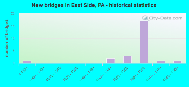
- New bridges - historical statistics
- 1Before 1900
- 21940-1949
- 31950-1959
- 171960-1969
- 11970-1979
- 11980-1989

- Reconstructed bridges - Historical Statistics
- 41970-1979
- 21980-1989
- 21990-1999
- 12000-2009


- Bridge Condition - Deck
- 9.1%Good
- 63.6%Satisfactory
- 27.3%Fair

- Bridge Condition - Superstructure
- 16.7%Good
- 25.0%Satisfactory
- 58.3%Fair

- Bridge Condition - Substructure
- 41.7%Satisfactory
- 50.0%Fair
- 8.3%Poor

- Bridge Condition - Channel
- 62.5%Satisfactory
- 12.5%Fair
- 25.0%Poor
Find on map >> Show street view
Structure Number: 8972, Location: EXIT 273 (40) WHITE HAVEN (Lat: 41.055506, Lng: -75.770017), Route carried "on" structure: Interstate 80, Year Built: 1965, Year Reconstructed: 1982, Status: Open, Structure Length: 25.48m (83.60ft), Average Daily Traffic: 15,840 (year 2020), Truck Traffic: 28%, Average Future Daily Traffic: 12,470 (year 2032), Design Load: HS 20+Mod, Features Intersected: SR 1005, LEHIGH R, RN RR
Minimum Vertical Clearance: 30+ m (98+ ft), Kilometerpoint: 0.000, Lanes on structure: 2, Lanes under structure: 2, Base Highway Network: Yes, Owner: State Highway Agency, Approaching Roadway Width: 11.6m (38.1ft), Skew: 10 degrees, Material/Design: Steel continuous, Design/Construction: Girder and Floorbeam System, Number Of Spans In Main Unit: 6, Number Of Approach Spans: 1, Length of Maximum Span: 38.7m (127.0ft), Curb or Sidewalk Widths: Left: 0.2m (0.7ft), Right: 0.2m (0.7ft), Curb-To-Curb Width: 10.1m (33.1ft), Out-to-Out Width: 11.1m (36.4ft)
Condition: Deck: Fair, Superstructure: Fair, Substructure: Fair, Channel: Satisfactory, Operating Rating: 35.4 metric tons, Method Used To Determine Operating Rating: Load Factor (LF), Inventory Rating: 20.9 metric tons, Method Used To Determine Inventory Rating: Load Factor (LF), Structural Evaluation: Somewhat better than minimum adequacy, Deck Geometry: Meets minimum limits, Underclear: High priority of corrective action, Waterway Adequacy: Superior to present desirable criteria, Approach Roadway Alignment: Equal to present desirable criteria, Length Of Structure Improvement: 25.60m (83.99ft), Designated Inspection Frequency: Every 24 months, Critical Feature Inspection Frequency: Every 24 months, Other Special Inspection Frequency: Every 12 months, Inspection Date: November 2020, Critical Feature Inspection Date: November 2020, Other Special Inspection Date: November 2020, Bridge Improvement Cost: $122,000, Roadway Improvement Cost: $359,000, Total Project Cost: $1,645,000, Deck Structure Type: Concrete Cast-file-Place, Wearing Surface/Protective System: Wearing Surface: Monolithic Concrete, Deck Protection: Epoxy Coated Reinforcing
Find on map >> Show street view
Structure Number: 8974, Location: EXIT 273 (40) WHITE HAVEN (Lat: 41.055736, Lng: -75.770128), Route carried "on" structure: Interstate 80, Year Built: 1965, Year Reconstructed: 1981, Status: Open, Structure Length: 23.07m (75.69ft), Average Daily Traffic: 15,543 (year 2020), Truck Traffic: 30%, Average Future Daily Traffic: 12,827 (year 2032), Design Load: HS 20+Mod, Features Intersected: SR 1005, LEHIGH R, RN RR
Minimum Vertical Clearance: 30+ m (98+ ft), Kilometerpoint: 0.000, Lanes on structure: 2, Lanes under structure: 2, Base Highway Network: Yes, Owner: State Highway Agency, Approaching Roadway Width: 11.6m (38.1ft), Skew: 10 degrees, Material/Design: Steel continuous, Design/Construction: Girder and Floorbeam System, Number Of Spans In Main Unit: 6, Length of Maximum Span: 38.7m (127.0ft), Curb or Sidewalk Widths: Left: 0.2m (0.7ft), Right: 0.2m (0.7ft), Curb-To-Curb Width: 10.1m (33.1ft), Out-to-Out Width: 11.1m (36.4ft)
Condition: Deck: Satisfactory, Superstructure: Fair, Substructure: Fair, Channel: Satisfactory, Operating Rating: 33.6 metric tons, Method Used To Determine Operating Rating: Load Factor (LF), Inventory Rating: 20.0 metric tons, Method Used To Determine Inventory Rating: Load Factor (LF), Structural Evaluation: Somewhat better than minimum adequacy, Deck Geometry: Meets minimum limits, Underclear: High priority of corrective action, Waterway Adequacy: Superior to present desirable criteria, Approach Roadway Alignment: Equal to present desirable criteria, Length Of Structure Improvement: 23.50m (77.10ft), Designated Inspection Frequency: Every 24 months, Critical Feature Inspection Frequency: Every 24 months, Inspection Date: November 2020, Critical Feature Inspection Date: November 2020, Bridge Improvement Cost: $198,000, Roadway Improvement Cost: $582,000, Total Project Cost: $2,670,000, Deck Structure Type: Concrete Cast-file-Place, Wearing Surface/Protective System: Wearing Surface: Bituminous, Membrane: Preformed Fabric, Deck Protection: Epoxy Coated Reinforcing
Find on map >> Show street view
Structure Number: 8977, Location: EXIT 277(42)TPKE-PA940 (Lat: 41.066667, Lng: -75.701667), Route carried "on" structure: Interstate 80, Year Built: 1965, Year Reconstructed: 1985, Status: Open, Structure Length: 3.84m (12.60ft), Average Daily Traffic: 10,848 (year 2021), Truck Traffic: 32%, Average Future Daily Traffic: 14,725 (year 2032), Design Load: HS 20+Mod, Features Intersected: RAMPS G&H SR 8004
Minimum Vertical Clearance: 30+ m (98+ ft), Kilometerpoint: 6.061, Lanes on structure: 2, Lanes under structure: 4, Base Highway Network: Yes, Owner: State Highway Agency, Approaching Roadway Width: 12.5m (41.0ft), Skew: 12 degrees, Material/Design: Prestressed concrete, Design/Construction: Box Beam or Girders - Single/Spread, Number Of Spans In Main Unit: 3, Length of Maximum Span: 18.3m (60.0ft), Curb-To-Curb Width: 12.2m (40.0ft), Out-to-Out Width: 13.3m (43.6ft)
Condition: Deck: Fair, Superstructure: Satisfactory, Substructure: Satisfactory, Operating Rating: 49.0 metric tons, Method Used To Determine Operating Rating: Load Factor (LF), Inventory Rating: 27.2 metric tons, Method Used To Determine Inventory Rating: Load Factor (LF), Structural Evaluation: Equal to present minimum criteria, Deck Geometry: Better than present minimum criteria, Underclear: High priority of corrective action, Approach Roadway Alignment: Equal to present desirable criteria, Length Of Structure Improvement: 4.60m (15.09ft), Designated Inspection Frequency: Every 24 months, Inspection Date: August 2020, Deck Structure Type: Concrete Cast-file-Place, Wearing Surface/Protective System: Wearing Surface: Bituminous, Membrane: Preformed Fabric, Deck Protection: Epoxy Coated Reinforcing
Find on map >> Show street view
Structure Number: 8978, Location: I-80 E.B. OVER I-476 (Lat: 41.068272, Lng: -75.694083), Route carried "on" structure: Interstate 80, Year Built: 1965, Year Reconstructed: 1983, Status: Open, Structure Length: 5.06m (16.60ft), Average Daily Traffic: 9,981 (year 2021), Truck Traffic: 27%, Average Future Daily Traffic: 14,093 (year 2032), Design Load: HS 20+Mod, Features Intersected: N.E.EXT. PA. TPK(I-476)
Minimum Vertical Clearance: 30+ m (98+ ft), Kilometerpoint: 6.880, Lanes on structure: 2, Lanes under structure: 4, Base Highway Network: Yes, Owner: State Highway Agency, Approaching Roadway Width: 12.5m (41.0ft), Skew: 13 degrees, Material/Design: Prestressed concrete, Design/Construction: Stringer/Multi-beam, Number Of Spans In Main Unit: 3, Length of Maximum Span: 26.8m (87.9ft), Curb-To-Curb Width: 12.8m (42.0ft), Out-to-Out Width: 13.9m (45.6ft)
Condition: Deck: Satisfactory, Superstructure: Fair, Substructure: Satisfactory, Operating Rating: 58.1 metric tons, Method Used To Determine Operating Rating: Load Factor (LF), Inventory Rating: 22.7 metric tons, Method Used To Determine Inventory Rating: Load Factor (LF), Structural Evaluation: Somewhat better than minimum adequacy, Deck Geometry: Equal to present desirable criteria, Underclear: High priority of corrective action, Approach Roadway Alignment: Equal to present desirable criteria, Length Of Structure Improvement: 6.00m (19.69ft), Designated Inspection Frequency: Every 24 months, Inspection Date: October 2019, Bridge Improvement Cost: $63,000, Roadway Improvement Cost: $186,000, Total Project Cost: $853,000, Deck Structure Type: Concrete Cast-file-Place, Wearing Surface/Protective System: Wearing Surface: Epoxy Overlay, Membrane: Epoxy, Deck Protection: Epoxy Coated Reinforcing
Find on map >> Show street view
Structure Number: 8979, Location: I-80 W.B. OVER I-476 (Lat: 41.068464, Lng: -75.694314), Route carried "on" structure: Interstate 80, Year Built: 1965, Year Reconstructed: 1983, Status: Open, Structure Length: 5.06m (16.60ft), Average Daily Traffic: 10,848 (year 2021), Truck Traffic: 32%, Average Future Daily Traffic: 14,725 (year 2032), Design Load: HS 20+Mod, Features Intersected: N.E.EXT.PA.TPK(I-476)
Minimum Vertical Clearance: 30+ m (98+ ft), Kilometerpoint: 6.864, Lanes on structure: 2, Lanes under structure: 4, Base Highway Network: Yes, Owner: State Highway Agency, Approaching Roadway Width: 12.5m (41.0ft), Skew: 13 degrees, Material/Design: Prestressed concrete, Design/Construction: Stringer/Multi-beam, Number Of Spans In Main Unit: 3, Length of Maximum Span: 26.8m (87.9ft), Curb-To-Curb Width: 12.8m (42.0ft), Out-to-Out Width: 13.9m (45.6ft)
Condition: Deck: Satisfactory, Superstructure: Fair, Substructure: Satisfactory, Operating Rating: 89.8 metric tons, Method Used To Determine Operating Rating: Load Factor (LF), Inventory Rating: 32.7 metric tons, Method Used To Determine Inventory Rating: Load Factor (LF), Structural Evaluation: Somewhat better than minimum adequacy, Deck Geometry: Equal to present desirable criteria, Underclear: High priority of corrective action, Approach Roadway Alignment: Equal to present desirable criteria, Length Of Structure Improvement: 6.00m (19.69ft), Designated Inspection Frequency: Every 24 months, Inspection Date: October 2019, Deck Structure Type: Concrete Cast-file-Place, Wearing Surface/Protective System: Wearing Surface: Epoxy Overlay, Membrane: Epoxy, Deck Protection: Epoxy Coated Reinforcing
Find on map >> Show street view
Structure Number: 9025, Location: 1.5MI.S.OF LEHIGH TANNERY (Lat: 41.022475, Lng: -75.712086), Route carried "on" structure: State highway 534, Year Built: 1949, Year Reconstructed: 2002, Status: Open, Structure Length: 0.79m (2.59ft), Average Daily Traffic: 611 (year 2022), Truck Traffic: 6%, Average Future Daily Traffic: 1,317 (year 2032), Design Load: HS 25 or greater, Features Intersected: HICKORY RUN
Minimum Vertical Clearance: 30+ m (98+ ft), Kilometerpoint: 8.142, Lanes on structure: 2, Owner: State Highway Agency, Approaching Roadway Width: 7.3m (24.0ft), Skew: 1 degrees, Material/Design: Prestressed concrete, Design/Construction: Slab, Number Of Spans In Main Unit: 1, Length of Maximum Span: 7.3m (24.0ft), Curb-To-Curb Width: 7.5m (24.6ft), Out-to-Out Width: 8.4m (27.6ft)
Condition: Deck: Good, Superstructure: Good, Substructure: Fair, Channel: Poor, Operating Rating: 97.1 metric tons, Method Used To Determine Operating Rating: Load Factor (LF), Inventory Rating: 53.5 metric tons, Method Used To Determine Inventory Rating: Load Factor (LF), Structural Evaluation: Somewhat better than minimum adequacy, Deck Geometry: Meets minimum limits, Waterway Adequacy: Equal to present desirable criteria, Approach Roadway Alignment: Equal to present desirable criteria, Length Of Structure Improvement: 1.40m (4.59ft), Designated Inspection Frequency: Every 24 months, Inspection Date: June 2020, Bridge Improvement Cost: $32,000, Roadway Improvement Cost: $94,000, Total Project Cost: $431,000, Wearing Surface/Protective System: Wearing Surface: Bituminous, Membrane: Other
Find on map >> Show street view
Structure Number: 9026, Location: .5 MI.S.OF LEHIGH TANNERY (Lat: 41.034586, Lng: -75.744347), Route carried "on" structure: State highway 534, Year Built: 1940, Status: Open, Structure Length: 1.49m (4.89ft), Average Daily Traffic: 611 (year 2022), Truck Traffic: 6%, Average Future Daily Traffic: 1,317 (year 2032), Design Load: HS 20, Features Intersected: BLACK CREEK
Minimum Vertical Clearance: 30+ m (98+ ft), Kilometerpoint: 5.237, Lanes on structure: 2, Owner: State Highway Agency, Approaching Roadway Width: 7.0m (23.0ft), Skew: 1 degrees, Material/Design: Steel, Design/Construction: Stringer/Multi-beam, Number Of Spans In Main Unit: 1, Length of Maximum Span: 13.7m (44.9ft), Curb-To-Curb Width: 6.8m (22.3ft), Out-to-Out Width: 7.6m (24.9ft)
Condition: Deck: Fair, Superstructure: Fair, Substructure: Fair, Channel: Satisfactory, Operating Rating: 45.4 metric tons, Method Used To Determine Operating Rating: Load Factor (LF), Inventory Rating: 27.2 metric tons, Method Used To Determine Inventory Rating: Load Factor (LF), Structural Evaluation: Somewhat better than minimum adequacy, Deck Geometry: Meets minimum limits, Waterway Adequacy: Better than present minimum criteria, Approach Roadway Alignment: Better than present minimum criteria, Length Of Structure Improvement: 2.20m (7.22ft), Designated Inspection Frequency: Every 24 months, Inspection Date: May 2021, Deck Structure Type: Concrete Cast-file-Place, Wearing Surface/Protective System: Wearing Surface: Bituminous
Find on map >> Show street view
Structure Number: 9027, Location: KIDDER TWP-E.SIDE BORO (Lat: 41.060533, Lng: -75.748636), Route carried "on" structure: State highway 534, Year Built: 1965, Year Reconstructed: 1996, Status: Open, Structure Length: 6.28m (20.60ft), Average Daily Traffic: 1,415 (year 2022), Truck Traffic: 23%, Average Future Daily Traffic: 2,041 (year 2032), Design Load: HS 20, Features Intersected: I-80(LR 1009)
Minimum Vertical Clearance: 30+ m (98+ ft), Kilometerpoint: 0.000, Lanes on structure: 2, Lanes under structure: 8, Owner: State Highway Agency, Approaching Roadway Width: 13.4m (44.0ft), Skew: 1 degrees, Material/Design: Prestressed concrete, Design/Construction: Box Beam or Girders - Single/Spread, Number Of Spans In Main Unit: 4, Length of Maximum Span: 20.1m (65.9ft), Curb-To-Curb Width: 9.8m (32.2ft), Out-to-Out Width: 10.8m (35.4ft)
Condition: Deck: Satisfactory, Superstructure: Fair, Substructure: Fair, Operating Rating: 49.9 metric tons, Method Used To Determine Operating Rating: Load Factor (LF), Inventory Rating: 29.9 metric tons, Method Used To Determine Inventory Rating: Load Factor (LF), Structural Evaluation: Somewhat better than minimum adequacy, Deck Geometry: Somewhat better than minimum adequacy, Underclear: High priority of corrective action, Approach Roadway Alignment: Equal to present desirable criteria, Length Of Structure Improvement: 7.20m (23.62ft), Designated Inspection Frequency: Every 24 months, Inspection Date: August 2020, Bridge Improvement Cost: $96,000, Roadway Improvement Cost: $281,000, Total Project Cost: $1,290,000, Deck Structure Type: Concrete Cast-file-Place, Wearing Surface/Protective System: Wearing Surface: Monolithic Concrete, Deck Protection: Epoxy Coated Reinforcing
Find on map >> Show street view
Structure Number: 9045, Location: WHITE HAVEN- E.SIDE BORO (Lat: 41.061289, Lng: -75.770769), Route carried "on" structure: State highway 940, Year Built: 1989, Status: Open, Structure Length: 16.98m (55.71ft), Average Daily Traffic: 2,672 (year 2021), Truck Traffic: 5%, Average Future Daily Traffic: 4,846 (year 2032), Design Load: HS 25 or greater, Features Intersected: LEHIGH RIVER
Minimum Vertical Clearance: 30+ m (98+ ft), Kilometerpoint: 0.000, Lanes on structure: 2, Owner: State Highway Agency, Approaching Roadway Width: 11.6m (38.1ft), Skew: 9 degrees, Material/Design: Prestressed concrete, Design/Construction: Stringer/Multi-beam, Number Of Spans In Main Unit: 4, Length of Maximum Span: 43.0m (141.1ft), Curb or Sidewalk Widths: Left: 0.2m (0.7ft), Right: 1.8m (5.9ft), Curb-To-Curb Width: 11.6m (38.1ft), Out-to-Out Width: 14.2m (46.6ft)
Condition: Deck: Satisfactory, Superstructure: Good, Substructure: Satisfactory, Channel: Satisfactory, Operating Rating: 85.3 metric tons, Method Used To Determine Operating Rating: Load Factor (LF), Inventory Rating: 28.1 metric tons, Method Used To Determine Inventory Rating: Load Factor (LF), Structural Evaluation: Equal to present minimum criteria, Deck Geometry: Somewhat better than minimum adequacy, Waterway Adequacy: Superior to present desirable criteria, Approach Roadway Alignment: Better than present minimum criteria, Length Of Structure Improvement: 17.70m (58.07ft), Designated Inspection Frequency: Every 24 months, Inspection Date: March 2021, Deck Structure Type: Concrete Cast-file-Place, Wearing Surface/Protective System: Wearing Surface: Monolithic Concrete, Deck Protection: Epoxy Coated Reinforcing
Find on map >> Show street view
Structure Number: 9119, Location: N.OF I80,I MI.W.OF TPKE. (Lat: 41.067428, Lng: -75.713356), Route carried "on" structure: City street T520, Year Built: 1890, Status: Open, Structure Length: 0.79m (2.59ft), Average Daily Traffic: 50 (year 1985), Average Future Daily Traffic: 250 (year 2005), Design Load: HS 20, Features Intersected: BLACK CREEK, Facility Carried by Structure: T-520(MECKES LANE)
Minimum Vertical Clearance: 30+ m (98+ ft), Kilometerpoint: 0.000, Lanes on structure: 1, Owner: Town or Township Highway Agency, Approaching Roadway Width: 5.2m (17.1ft), Material/Design: Masonry, Design/Construction: Arch - Deck, Number Of Spans In Main Unit: 1, Length of Maximum Span: 7.9m (25.9ft), Curb-To-Curb Width: 4.8m (15.7ft), Out-to-Out Width: 6.2m (20.3ft)
Condition: Superstructure: Fair, Substructure: Fair, Channel: Fair, Operating Rating: 49.0 metric tons, Method Used To Determine Operating Rating: Field evaluation and documented engineering judgment, Inventory Rating: 32.7 metric tons, Method Used To Determine Inventory Rating: Field evaluation and documented engineering judgment, Structural Evaluation: Somewhat better than minimum adequacy, Deck Geometry: Equal to present desirable criteria, Waterway Adequacy: Better than present minimum criteria, Approach Roadway Alignment: Equal to present desirable criteria, Length Of Structure Improvement: 1.10m (3.61ft), Designated Inspection Frequency: Every 24 months, Inspection Date: March 2021, Bridge Improvement Cost: $37,000, Roadway Improvement Cost: $232,000, Total Project Cost: $496,000
Find on map >> Show street view
Structure Number: 9171, Location: NEAR POCONO INTERCHANGE (Lat: 41.071828, Lng: -75.700342), Route carried "on" structure: Interstate 476, Year Built: 1955, Year Reconstructed: 1989, Status: Open, Structure Length: 4.39m (14.40ft), Average Daily Traffic: 23,657 (year 2011), Truck Traffic: 20%, Average Future Daily Traffic: 32,200 (year 2030), Design Load: HS 20, Features Intersected: SR 0940, LR408
Minimum Vertical Clearance: 30+ m (98+ ft), Kilometerpoint: 0.000, Lanes on structure: 4, Lanes under structure: 2, Base Highway Network: Yes, Toll: On toll road, Owner: State Toll Authority, Approaching Roadway Width: 21.0m (68.9ft), Skew: 35 degrees, Material/Design: Steel continuous, Design/Construction: Stringer/Multi-beam, Number Of Spans In Main Unit: 3, Length of Maximum Span: 15.5m (50.9ft), Curb or Sidewalk Widths: Left: 0.2m (0.7ft), Right: 0.2m (0.7ft), Curb-To-Curb Width: 9.0m (29.5ft), Out-to-Out Width: 19.7m (64.6ft)
Condition: Deck: Satisfactory, Superstructure: Satisfactory, Substructure: Satisfactory, Operating Rating: 79.8 metric tons, Method Used To Determine Operating Rating: Load Factor (LF), Inventory Rating: 48.1 metric tons, Method Used To Determine Inventory Rating: Load Factor (LF), Structural Evaluation: Equal to present minimum criteria, Deck Geometry: High priority of replacement, Underclear: Meets minimum limits, Approach Roadway Alignment: Equal to present desirable criteria, Length Of Structure Improvement: 4.50m (14.76ft), Designated Inspection Frequency: Every 24 months, Inspection Date: August 2019, Bridge Improvement Cost: $103,000, Roadway Improvement Cost: $303,000, Total Project Cost: $1,388,000, Deck Structure Type: Concrete Cast-file-Place, Wearing Surface/Protective System: Wearing Surface: Latex Concrete
Find on map >> Show street view
Structure Number: 41879, Location: HICKORY RUN STATE PARK (Lat: 41.041100, Lng: -75.697400), Route carried "on" structure: ServiceState lands road , Year Built: 1970, Year Reconstructed: 2000, Status: Posted for load, Structure Length: 0.98m (3.22ft), Average Daily Traffic: 10 (year 2012), Average Future Daily Traffic: 10 (year 2032), Design Load: HS 20, Features Intersected: HICKORY RUN, Facility Carried by Structure: POOL ROAD
Minimum Vertical Clearance: 30+ m (98+ ft), Kilometerpoint: 0.000, Lanes on structure: 1, Owner: State Park, Forest, or Reservation Agency, Approaching Roadway Width: 3.0m (9.8ft), Material/Design: Steel, Design/Construction: Stringer/Multi-beam, Number Of Spans In Main Unit: 1, Length of Maximum Span: 9.4m (30.8ft), Curb-To-Curb Width: 3.4m (11.2ft), Out-to-Out Width: 3.7m (12.1ft)
Condition: Deck: Satisfactory, Superstructure: Satisfactory, Substructure: Poor, Channel: Satisfactory, Operating Rating: 34.5 metric tons, Method Used To Determine Operating Rating: Load Factor (LF), Inventory Rating: 20.9 metric tons, Method Used To Determine Inventory Rating: Load Factor (LF), Structural Evaluation: Meets minimum limits, Deck Geometry: High priority of corrective action, Waterway Adequacy: Better than present minimum criteria, Approach Roadway Alignment: Equal to present desirable criteria, Bridge Posting: Required (Relationship of Operating Rating to Maximum Legal Load: 20.0 - 29.9% below), Length Of Structure Improvement: 1.00m (3.28ft), Designated Inspection Frequency: Every 24 months, Other Special Inspection Frequency: Every 12 months, Inspection Date: April 2020, Other Special Inspection Date: April 2021, Deck Structure Type: Wood or Timber, Wearing Surface/Protective System: Wearing Surface: Wood or Timber
Find on map >> Show street view
Structure Number: 57023, Location: 1000FT FROM MIDDLEBURG RD (Lat: 41.085389, Lng: -75.772389), Route carried "on" structure: City street , Year Built: 1963, Status: Open, Structure Length: 0.85m (2.79ft), Average Daily Traffic: 15 (year 2020), Average Future Daily Traffic: 20 (year 2040), Features Intersected: Wright Creek, Facility Carried by Structure: Ice Lake Drive
Minimum Vertical Clearance: 30+ m (98+ ft), Kilometerpoint: 0.000, Lanes on structure: 2, Owner: Town or Township Highway Agency, Approaching Roadway Width: 4.9m (16.1ft), Skew: 6 degrees, Material/Design: Concrete, Design/Construction: Culvert, Number Of Spans In Main Unit: 1, Length of Maximum Span: 8.5m (27.9ft), Curb-To-Curb Width: 11.9m (39.0ft), Out-to-Out Width: 12.7m (41.7ft)
Condition: Channel: Poor, Culverts: Satisfactory, Operating Rating: 75.3 metric tons, Method Used To Determine Operating Rating: Field evaluation and documented engineering judgment, Inventory Rating: 45.4 metric tons, Method Used To Determine Inventory Rating: Field evaluation and documented engineering judgment, Structural Evaluation: Equal to present minimum criteria, Deck Geometry: Superior to present desirable criteria, Waterway Adequacy: Better than present minimum criteria, Approach Roadway Alignment: Equal to present desirable criteria, Designated Inspection Frequency: Every 24 months, Other Special Inspection Frequency: Every 6 months, Inspection Date: October 2020, Other Special Inspection Date: April 2021
Find on map >> Show street view
Structure Number: 8972, Location: EXIT 273 (40) WHITE HAVEN (Lat: 41.055506, Lng: -75.770017), Route carried "under" structure: State highway , Year Built: 1965, Structure Length: 0. m, Average Daily Traffic: 62 (year 2021), Truck Traffic: 3%, Features Intersected: SR 1005, LEHIGH R, RN RR, Facility Carried by Structure: I-80 EB (LR1009)
Minimum Vertical Clearance: 14.87m (48.79ft), Kilometerpoint: 2.279, Lanes on structure: 2, Lanes under structure: 2, Material/Design: Steel continuous, Design/Construction: Girder and Floorbeam System, Length of Maximum Span: 38.7m (127.0ft)
Find on map >> Show street view
Structure Number: 8974, Location: EXIT 273 (40) WHITE HAVEN (Lat: 41.055736, Lng: -75.770128), Route carried "under" structure: State highway , Year Built: 1965, Structure Length: 0. m, Average Daily Traffic: 62 (year 2021), Truck Traffic: 3%, Features Intersected: SR 1005, LEHIGH R, RN RR, Facility Carried by Structure: I-80 WB (LR 1009)
Minimum Vertical Clearance: 14.45m (47.41ft), Kilometerpoint: 2.279, Lanes on structure: 2, Lanes under structure: 2, Material/Design: Steel continuous, Design/Construction: Girder and Floorbeam System, Length of Maximum Span: 38.7m (127.0ft)
Find on map >> Show street view
Structure Number: 8976, Location: EXIT 277(42)TPKE-PA940 (Lat: 41.066281, Lng: -75.702050), Route carried "under" structure: Ramp State highway , Year Built: 1965, Structure Length: 0. m, Average Daily Traffic: 789 (year 2021), Truck Traffic: 7%, Features Intersected: RAMPS G & H SR 8004, Facility Carried by Structure: I80 EB (LR1009)
Minimum Vertical Clearance: 4.60m (15.09ft), Kilometerpoint: 0.000, Lanes on structure: 2, Lanes under structure: 2, Material/Design: Prestressed concrete, Design/Construction: Box Beam or Girders - Single/Spread, Length of Maximum Span: 18.3m (60.0ft)
Find on map >> Show street view
Structure Number: 8976, Location: EXIT 277(42)TPKE-PA940 (Lat: 41.066281, Lng: -75.702050), Route carried "under" structure: Ramp State highway , Year Built: 1965, Structure Length: 0. m, Average Daily Traffic: 3,677 (year 2021), Truck Traffic: 7%, Features Intersected: RAMPS G & H SR 8004, Facility Carried by Structure: I80 EB (LR1009)
Minimum Vertical Clearance: 4.69m (15.39ft), Kilometerpoint: 0.000, Lanes on structure: 2, Lanes under structure: 2, Material/Design: Prestressed concrete, Design/Construction: Box Beam or Girders - Single/Spread, Length of Maximum Span: 18.3m (60.0ft)
Find on map >> Show street view
Structure Number: 8977, Location: EXIT 277(42)TPKE-PA940 (Lat: 41.066667, Lng: -75.701667), Route carried "under" structure: Ramp State highway , Year Built: 1965, Structure Length: 0. m, Average Daily Traffic: 4,441 (year 2021), Truck Traffic: 7%, Features Intersected: RAMPS G&H SR 8004, Facility Carried by Structure: I80 WB (LR1009)
Minimum Vertical Clearance: 4.63m (15.19ft), Kilometerpoint: 0.000, Lanes on structure: 2, Lanes under structure: 2, Material/Design: Prestressed concrete, Design/Construction: Box Beam or Girders - Single/Spread, Length of Maximum Span: 18.3m (60.0ft)
Find on map >> Show street view
Structure Number: 8977, Location: EXIT 277(42)TPKE-PA940 (Lat: 41.066667, Lng: -75.701667), Route carried "under" structure: Ramp State highway , Year Built: 1965, Structure Length: 0. m, Average Daily Traffic: 4,436 (year 2021), Truck Traffic: 7%, Features Intersected: RAMPS G&H SR 8004, Facility Carried by Structure: I80 WB (LR1009)
Minimum Vertical Clearance: 4.72m (15.49ft), Kilometerpoint: 0.000, Lanes on structure: 2, Lanes under structure: 2, Material/Design: Prestressed concrete, Design/Construction: Box Beam or Girders - Single/Spread, Length of Maximum Span: 18.3m (60.0ft)
Find on map >> Show street view
Structure Number: 8978, Location: I-80 E.B. OVER I-476 (Lat: 41.068272, Lng: -75.694083), Route carried "under" structure: Interstate 476, Year Built: 1965, Structure Length: 0. m, Average Daily Traffic: 200 (year 1992), Truck Traffic: 2%, Features Intersected: N.E.EXT. PA. TPK(I-476), Facility Carried by Structure: I-80 EB(LR1009)
Minimum Vertical Clearance: 4.36m (14.30ft), Kilometerpoint: 0.000, Lanes on structure: 2, Lanes under structure: 4, Toll: On toll road, Material/Design: Prestressed concrete, Design/Construction: Stringer/Multi-beam, Length of Maximum Span: 26.8m (87.9ft)
Find on map >> Show street view
Structure Number: 8979, Location: I-80 W.B. OVER I-476 (Lat: 41.068464, Lng: -75.694314), Route carried "under" structure: Interstate 476, Year Built: 1965, Structure Length: 0. m, Average Daily Traffic: 200 (year 1992), Truck Traffic: 2%, Features Intersected: N.E.EXT.PA.TPK(I-476), Facility Carried by Structure: I80 WB (LR 1009)
Minimum Vertical Clearance: 4.39m (14.40ft), Kilometerpoint: 0.000, Lanes on structure: 2, Lanes under structure: 4, Material/Design: Prestressed concrete, Design/Construction: Stringer/Multi-beam, Length of Maximum Span: 26.8m (87.9ft)
Find on map >> Show street view
Structure Number: 9027, Location: KIDDER TWP-E.SIDE BORO (Lat: 41.060533, Lng: -75.748636), Route carried "under" structure: Interstate 80, Year Built: 1965, Structure Length: 0. m, Average Daily Traffic: 12,956 (year 2021), Truck Traffic: 63%, Features Intersected: I-80(LR 1009), Facility Carried by Structure: PA 534(LR 13040)
Minimum Vertical Clearance: 5.06m (16.60ft), Kilometerpoint: 2.033, Lanes on structure: 2, Lanes under structure: 4, Material/Design: Prestressed concrete, Design/Construction: Box Beam or Girders - Single/Spread, Length of Maximum Span: 20.1m (65.9ft)
Find on map >> Show street view
Structure Number: 9027, Location: KIDDER TWP-E.SIDE BORO (Lat: 41.060533, Lng: -75.748636), Route carried "under" structure: Interstate 80, Year Built: 1965, Structure Length: 0. m, Average Daily Traffic: 13,404 (year 2021), Truck Traffic: 59%, Features Intersected: I-80(LR 1009), Facility Carried by Structure: PA 534(LR 13040)
Minimum Vertical Clearance: 5.49m (18.01ft), Kilometerpoint: 2.029, Lanes on structure: 2, Lanes under structure: 4, Material/Design: Prestressed concrete, Design/Construction: Box Beam or Girders - Single/Spread, Length of Maximum Span: 20.1m (65.9ft)
Find on map >> Show street view
Structure Number: 9171, Location: NEAR POCONO INTERCHANGE (Lat: 41.071828, Lng: -75.700342), Route carried "under" structure: State highway 940, Year Built: 1955, Structure Length: 0. m, Average Daily Traffic: 2,212 (year 2022), Truck Traffic: 9%, Features Intersected: SR 0940, LR408, Facility Carried by Structure: PA TPK (I-476)
Minimum Vertical Clearance: 4.38m (14.37ft), Kilometerpoint: 6.389, Lanes on structure: 4, Lanes under structure: 2, Material/Design: Steel continuous, Design/Construction: Stringer/Multi-beam, Length of Maximum Span: 15.5m (50.9ft)
Find on map >> Show street view
Structure Number: 9172, Location: POCONO INTERCHANGE (Lat: 41.073642, Lng: -75.706431), Route carried "under" structure: Ramp Interstate 476, Year Built: 1955, Structure Length: 0. m, Average Daily Traffic: 7,763 (year 1994), Truck Traffic: 16%, Features Intersected: PA TPK (I-476) RP AB
Minimum Vertical Clearance: 4.47m (14.67ft), Kilometerpoint: 0.000, Lanes on structure: 2, Lanes under structure: 2, Toll: On toll road, Material/Design: Steel, Design/Construction: Stringer/Multi-beam, Length of Maximum Span: 12.2m (40.0ft)