Bridge Statistics for East Pittsburgh, Pennsylvania (PA)
Condition, Traffic, Stress, Structural Evaluation, Project Costs
- National Bridge Inventory (NBI) Statistics
- 13Number of bridges
- 636ft / 194mTotal length
- $24,850,000Total costs
- 67,241Total average daily traffic
- 3,850Total average daily truck traffic
- National Bridge Inventory (NBI) Registered Bridges for East Pittsburgh
- No street view available for this location
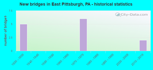
- New bridges - historical statistics
- 51930-1939
- 61970-1979
- 22010-2019

- Reconstructed bridges - Historical Statistics
- 11970-1979
- 01980-1989
- 01990-1999
- 02000-2009
- 42010-2019


- Bridge Condition - Deck
- 14.3%Very good
- 71.4%Good
- 14.3%Satisfactory

- Bridge Condition - Superstructure
- 71.4%Very good
- 14.3%Good
- 14.3%Fair

- Bridge Condition - Substructure
- 42.9%Very good
- 42.9%Satisfactory
- 14.3%Fair
Find on map >> Show street view
Structure Number: 673, Location: RT 30 OVER BESSEMER AVE (Lat: 40.394908, Lng: -79.838653), Route carried "on" structure: US 30, Year Built: 1937, Year Reconstructed: 2016, Status: Open, Structure Length: 1.77m (5.81ft), Average Daily Traffic: 19,680 (year 2022), Truck Traffic: 6%, Average Future Daily Traffic: 22,553 (year 2032), Design Load: HL 93, Features Intersected: OVER BESSEMER AVE
Minimum Vertical Clearance: 30+ m (98+ ft), Kilometerpoint: 17.346, Lanes on structure: 4, Lanes under structure: 2, Base Highway Network: Yes, Owner: State Highway Agency, Approaching Roadway Width: 12.2m (40.0ft), Skew: 1 degrees, Material/Design: Steel, Design/Construction: Stringer/Multi-beam, Number Of Spans In Main Unit: 1, Length of Maximum Span: 16.5m (54.1ft), Curb or Sidewalk Widths: Left: 0.0m, Right: 2.0m (6.6ft), Curb-To-Curb Width: 12.2m (40.0ft), Out-to-Out Width: 17.1m (56.1ft)
Condition: Deck: Very good, Superstructure: Very good, Substructure: Very good, Operating Rating: 54.1 metric tons, Method Used To Determine Operating Rating: Assigned ratings based on Load and Resistance Factor Design (LRFD) reported by rating factor (RF) using HL93 loadings, Inventory Rating: 41.5 metric tons, Method Used To Determine Inventory Rating: Assigned ratings based on Load and Resistance Factor Design (LRFD) reported by rating factor (RF) using HL93 loadings, Structural Evaluation: Equal to present desirable criteria, Deck Geometry: High priority of replacement, Underclear: Equal to present minimum criteria, Approach Roadway Alignment: Equal to present desirable criteria, Length Of Structure Improvement: 1.70m (5.58ft), Designated Inspection Frequency: Every 24 months, Inspection Date: September 2021, Bridge Improvement Cost: $21,000, Roadway Improvement Cost: $61,000, Total Project Cost: $279,000, Deck Structure Type: Concrete Cast-file-Place, Wearing Surface/Protective System: Wearing Surface: Latex Concrete, Deck Protection: Epoxy Coated Reinforcing
Find on map >> Show street view
Structure Number: 674, Location: Westinghouse Bridge (Lat: 40.392700, Lng: -79.836272), Route carried "on" structure: US 30, Year Built: 1931, Year Reconstructed: 1983, Status: Open, Structure Length: 46.45m (152.40ft), Average Daily Traffic: 19,680 (year 2022), Truck Traffic: 6%, Average Future Daily Traffic: 22,553 (year 2032), Design Load: HS 20, Features Intersected: LR1074,TURTLE CR,N&S RR, Facility Carried by Structure: Westinghouse Brg
Minimum Vertical Clearance: 30+ m (98+ ft), Kilometerpoint: 17.606, Lanes on structure: 4, Lanes under structure: 8, Base Highway Network: Yes, Owner: State Highway Agency, Approaching Roadway Width: 14.6m (47.9ft), Material/Design: Concrete, Design/Construction: Arch - Deck, Number Of Spans In Main Unit: 5, Length of Maximum Span: 140.2m (460.0ft), Curb or Sidewalk Widths: Left: 1.5m (4.9ft), Right: 1.5m (4.9ft), Curb-To-Curb Width: 14.6m (47.9ft), Out-to-Out Width: 19.5m (64.0ft)
Condition: Deck: Satisfactory, Superstructure: Fair, Substructure: Fair, Channel: Very good, Operating Rating: 51.7 metric tons, Method Used To Determine Operating Rating: Load Factor (LF), Inventory Rating: 30.8 metric tons, Method Used To Determine Inventory Rating: Load Factor (LF), Structural Evaluation: Somewhat better than minimum adequacy, Deck Geometry: High priority of replacement, Underclear: High priority of corrective action, Waterway Adequacy: Superior to present desirable criteria, Approach Roadway Alignment: Better than present minimum criteria, Length Of Structure Improvement: 46.50m (152.56ft), Designated Inspection Frequency: Every 24 months, Inspection Date: November 2020, Bridge Improvement Cost: $285,000, Roadway Improvement Cost: $839,000, Total Project Cost: $3,845,000, Deck Structure Type: Concrete Cast-file-Place, Wearing Surface/Protective System: Wearing Surface: Monolithic Concrete, Deck Protection: Epoxy Coated Reinforcing
Find on map >> Show street view
Structure Number: 1547, Location: TriBoro Expressway (Lat: 40.394833, Lng: -79.836828), Route carried "on" structure: State highway , Year Built: 1974, Year Reconstructed: 2010, Status: Open, Structure Length: 22.49m (73.79ft), Average Daily Traffic: 3,169 (year 2022), Truck Traffic: 5%, Average Future Daily Traffic: 4,726 (year 2032), Design Load: HS 20, Features Intersected: BRADDOCK AVE,RAMP B, Facility Carried by Structure: RAMP R
Minimum Vertical Clearance: 30+ m (98+ ft), Kilometerpoint: 5.658, Lanes on structure: 2, Lanes under structure: 3, Base Highway Network: Yes, Owner: State Highway Agency, Approaching Roadway Width: 8.5m (27.9ft), Skew: 9 degrees, Material/Design: Steel continuous, Design/Construction: Stringer/Multi-beam, Number Of Spans In Main Unit: 7, Length of Maximum Span: 39.0m (128.0ft), Curb or Sidewalk Widths: Left: 0.2m (0.7ft), Right: 1.6m (5.2ft), Curb-To-Curb Width: 8.5m (27.9ft), Out-to-Out Width: 11.0m (36.1ft)
Condition: Deck: Good, Superstructure: Very good, Substructure: Satisfactory, Operating Rating: 71.7 metric tons, Method Used To Determine Operating Rating: Load Factor (LF), Inventory Rating: 42.6 metric tons, Method Used To Determine Inventory Rating: Load Factor (LF), Structural Evaluation: Equal to present minimum criteria, Deck Geometry: High priority of corrective action, Underclear: High priority of corrective action, Approach Roadway Alignment: Equal to present desirable criteria, Length Of Structure Improvement: 21.50m (70.54ft), Designated Inspection Frequency: Every 24 months, Inspection Date: August 2021, Bridge Improvement Cost: $633,000, Roadway Improvement Cost: $4,571,000, Total Project Cost: $8,543,000, Deck Structure Type: Concrete Cast-file-Place, Wearing Surface/Protective System: Wearing Surface: Monolithic Concrete, Deck Protection: Epoxy Coated Reinforcing
Find on map >> Show street view
Structure Number: 1549, Location: TriBoro Expressway (Lat: 40.395339, Lng: -79.837019), Route carried "on" structure: State highway , Year Built: 1974, Year Reconstructed: 2010, Status: Open, Structure Length: 35.27m (115.72ft), Average Daily Traffic: 3,432 (year 2022), Truck Traffic: 5%, Average Future Daily Traffic: 3,344 (year 2032), Design Load: HS 20, Features Intersected: UNION R R, Facility Carried by Structure: RAMP R
Minimum Vertical Clearance: 30+ m (98+ ft), Kilometerpoint: 5.658, Lanes on structure: 2, Base Highway Network: Yes, Owner: State Highway Agency, Approaching Roadway Width: 8.5m (27.9ft), Skew: 9 degrees, Material/Design: Steel continuous, Design/Construction: Stringer/Multi-beam, Number Of Spans In Main Unit: 11, Number Of Approach Spans: 1, Length of Maximum Span: 37.8m (124.0ft), Curb or Sidewalk Widths: Left: 0.2m (0.7ft), Right: 0.2m (0.7ft), Curb-To-Curb Width: 8.5m (27.9ft), Out-to-Out Width: 9.8m (32.2ft)
Condition: Deck: Good, Superstructure: Very good, Substructure: Satisfactory, Operating Rating: 60.8 metric tons, Method Used To Determine Operating Rating: Load Factor (LF), Inventory Rating: 36.3 metric tons, Method Used To Determine Inventory Rating: Load Factor (LF), Structural Evaluation: Equal to present minimum criteria, Deck Geometry: High priority of corrective action, Underclear: High priority of corrective action, Approach Roadway Alignment: Equal to present desirable criteria, Length Of Structure Improvement: 31.50m (103.35ft), Designated Inspection Frequency: Every 24 months, Critical Feature Inspection Frequency: Every 24 months, Inspection Date: August 2021, Critical Feature Inspection Date: August 2021, Bridge Improvement Cost: $299,000, Roadway Improvement Cost: $881,000, Total Project Cost: $4,038,000, Deck Structure Type: Concrete Cast-file-Place, Wearing Surface/Protective System: Wearing Surface: Monolithic Concrete, Deck Protection: Epoxy Coated Reinforcing
Find on map >> Show street view
Structure Number: 1635, Location: TriBoro Expressway (Lat: 40.396667, Lng: -79.838333), Route carried "on" structure: Spur State highway , Year Built: 1974, Year Reconstructed: 2010, Status: Open, Structure Length: 36.33m (119.19ft), Average Daily Traffic: 6,668 (year 2022), Truck Traffic: 6%, Average Future Daily Traffic: 8,808 (year 2032), Design Load: HS 20, Features Intersected: NS RR,UNION RR,MAIN ST, Facility Carried by Structure: RAMP S
Minimum Vertical Clearance: 30+ m (98+ ft), Kilometerpoint: 0.410, Lanes on structure: 4, Lanes under structure: 2, Base Highway Network: Yes, Owner: State Highway Agency, Approaching Roadway Width: 18.3m (60.0ft), Skew: 29 degrees, Material/Design: Steel continuous, Design/Construction: Stringer/Multi-beam, Number Of Spans In Main Unit: 8, Number Of Approach Spans: 2, Length of Maximum Span: 49.4m (162.1ft), Curb or Sidewalk Widths: Left: 0.2m (0.7ft), Right: 0.2m (0.7ft), Curb-To-Curb Width: 18.3m (60.0ft), Out-to-Out Width: 19.5m (64.0ft)
Condition: Deck: Good, Superstructure: Good, Substructure: Satisfactory, Operating Rating: 59.0 metric tons, Method Used To Determine Operating Rating: Load Factor (LF), Inventory Rating: 35.4 metric tons, Method Used To Determine Inventory Rating: Load Factor (LF), Structural Evaluation: Equal to present minimum criteria, Deck Geometry: Meets minimum limits, Underclear: Equal to present minimum criteria, Approach Roadway Alignment: Equal to present desirable criteria, Length Of Structure Improvement: 40.20m (131.89ft), Designated Inspection Frequency: Every 24 months, Critical Feature Inspection Frequency: Every 24 months, Inspection Date: August 2021, Critical Feature Inspection Date: August 2021, Bridge Improvement Cost: $603,000, Roadway Improvement Cost: $1,777,000, Total Project Cost: $8,145,000, Deck Structure Type: Concrete Cast-file-Place, Wearing Surface/Protective System: Wearing Surface: Monolithic Concrete, Deck Protection: Epoxy Coated Reinforcing
Find on map >> Show street view
Structure Number: 48208, Location: TriBoro Expressway (Lat: 40.393514, Lng: -79.835389), Route carried "on" structure: State highway , Year Built: 2013, Status: Open, Structure Length: 25.63m (84.09ft), Average Daily Traffic: 3,169 (year 2022), Truck Traffic: 5%, Average Future Daily Traffic: 2,988 (year 2032), Design Load: HL 93, Features Intersected: ELDER ST, TURTLE CRK, RR, Facility Carried by Structure: RAMP T
Minimum Vertical Clearance: 30+ m (98+ ft), Kilometerpoint: 5.658, Lanes on structure: 2, Lanes under structure: 1, Base Highway Network: Yes, Owner: State Highway Agency, Approaching Roadway Width: 8.5m (27.9ft), Material/Design: Steel continuous, Design/Construction: Stringer/Multi-beam, Number Of Spans In Main Unit: 4, Number Of Approach Spans: 2, Length of Maximum Span: 63.1m (207.0ft), Curb or Sidewalk Widths: Left: 1.9m (6.2ft), Right: 0.6m (2.0ft), Curb-To-Curb Width: 8.5m (27.9ft), Out-to-Out Width: 11.1m (36.4ft)
Condition: Deck: Good, Superstructure: Very good, Substructure: Very good, Channel: Very good, Operating Rating: 63.5 metric tons, Method Used To Determine Operating Rating: Assigned ratings based on Load and Resistance Factor Design (LRFD) reported by rating factor (RF) using HL93 loadings, Inventory Rating: 43.7 metric tons, Method Used To Determine Inventory Rating: Assigned ratings based on Load and Resistance Factor Design (LRFD) reported by rating factor (RF) using HL93 loadings, Structural Evaluation: Equal to present desirable criteria, Deck Geometry: High priority of corrective action, Underclear: High priority of corrective action, Waterway Adequacy: Superior to present desirable criteria, Approach Roadway Alignment: Equal to present minimum criteria, Designated Inspection Frequency: Every 24 months, Critical Feature Inspection Frequency: Every 24 months, Inspection Date: August 2021, Critical Feature Inspection Date: August 2021, Deck Structure Type: Concrete Cast-file-Place, Wearing Surface/Protective System: Wearing Surface: Monolithic Concrete, Deck Protection: Epoxy Coated Reinforcing
Find on map >> Show street view
Structure Number: 48209, Location: TriBoro Expressway (Lat: 40.393372, Lng: -79.835078), Route carried "on" structure: State highway , Year Built: 2013, Status: Open, Structure Length: 25.63m (84.09ft), Average Daily Traffic: 3,432 (year 2022), Truck Traffic: 5%, Average Future Daily Traffic: 3,344 (year 2032), Design Load: HL 93, Features Intersected: ELDER ST, TURTLE CRK, RR, Facility Carried by Structure: RAMP T
Minimum Vertical Clearance: 30+ m (98+ ft), Kilometerpoint: 5.658, Lanes on structure: 2, Lanes under structure: 1, Base Highway Network: Yes, Owner: State Highway Agency, Approaching Roadway Width: 8.5m (27.9ft), Material/Design: Steel continuous, Design/Construction: Stringer/Multi-beam, Number Of Spans In Main Unit: 4, Number Of Approach Spans: 2, Length of Maximum Span: 61.3m (201.1ft), Curb or Sidewalk Widths: Left: 0.2m (0.7ft), Right: 0.6m (2.0ft), Curb-To-Curb Width: 8.5m (27.9ft), Out-to-Out Width: 9.8m (32.2ft)
Condition: Deck: Good, Superstructure: Very good, Substructure: Very good, Channel: Very good, Operating Rating: 76.8 metric tons, Method Used To Determine Operating Rating: Assigned ratings based on Load and Resistance Factor Design (LRFD) reported by rating factor (RF) using HL93 loadings, Inventory Rating: 48.3 metric tons, Method Used To Determine Inventory Rating: Assigned ratings based on Load and Resistance Factor Design (LRFD) reported by rating factor (RF) using HL93 loadings, Structural Evaluation: Equal to present desirable criteria, Deck Geometry: High priority of corrective action, Underclear: High priority of corrective action, Waterway Adequacy: Superior to present desirable criteria, Approach Roadway Alignment: Equal to present minimum criteria, Designated Inspection Frequency: Every 24 months, Critical Feature Inspection Frequency: Every 24 months, Inspection Date: August 2021, Critical Feature Inspection Date: August 2021, Deck Structure Type: Concrete Cast-file-Place, Wearing Surface/Protective System: Wearing Surface: Monolithic Concrete, Deck Protection: Epoxy Coated Reinforcing
Find on map >> Show street view
Structure Number: 673, Location: RT 30 OVER BESSEMER AVE (Lat: 40.394908, Lng: -79.838653), Route carried "under" structure: City street , Year Built: 1937, Structure Length: 0. m, Average Daily Traffic: 1,000 (year 2004), Truck Traffic: 1%, Features Intersected: OVER BESSEMER AVE, Facility Carried by Structure: SR 0030 EB WB
Minimum Vertical Clearance: 5.18m (16.99ft), Kilometerpoint: 0.000, Lanes on structure: 4, Lanes under structure: 2, Material/Design: Steel, Design/Construction: Stringer/Multi-beam, Length of Maximum Span: 16.5m (54.1ft)
Find on map >> Show street view
Structure Number: 674, Location: Westinghouse Bridge (Lat: 40.392700, Lng: -79.836272), Route carried "under" structure: State highway , Year Built: 1931, Structure Length: 0. m, Average Daily Traffic: 3,334 (year 2022), Truck Traffic: 6%, Features Intersected: LR1074,TURTLE CR,N&S RR, Facility Carried by Structure: Westinghouse Brg
Minimum Vertical Clearance: 15.85m (52.00ft), Kilometerpoint: 0.410, Lanes on structure: 4, Lanes under structure: 4, Material/Design: Concrete, Design/Construction: Arch - Deck, Length of Maximum Span: 140.2m (460.0ft)
Find on map >> Show street view
Structure Number: 1547, Location: TriBoro Expressway (Lat: 40.394833, Lng: -79.836828), Route carried "under" structure: Ramp State highway , Year Built: 1974, Structure Length: 0. m, Average Daily Traffic: 143 (year 2022), Truck Traffic: 7%, Features Intersected: BRADDOCK AVE,RAMP B, Facility Carried by Structure: RAMP R
Minimum Vertical Clearance: 5.33m (17.49ft), Kilometerpoint: 0.000, Lanes on structure: 2, Lanes under structure: 1, Material/Design: Steel continuous, Design/Construction: Stringer/Multi-beam, Length of Maximum Span: 39.0m (128.0ft)
Find on map >> Show street view
Structure Number: 1547, Location: TriBoro Expressway (Lat: 40.394833, Lng: -79.836828), Route carried "under" structure: City street , Year Built: 1974, Structure Length: 0. m, Average Daily Traffic: 100 (year 2000), Truck Traffic: 7%, Features Intersected: BRADDOCK AVE,RAMP B, Facility Carried by Structure: RAMP R
Minimum Vertical Clearance: 10.84m (35.56ft), Kilometerpoint: 0.000, Lanes on structure: 2, Lanes under structure: 2, Material/Design: Steel continuous, Design/Construction: Stringer/Multi-beam, Length of Maximum Span: 39.0m (128.0ft)
Find on map >> Show street view
Structure Number: 1635, Location: TriBoro Expressway (Lat: 40.396667, Lng: -79.838333), Route carried "under" structure: City street , Year Built: 1974, Structure Length: 0. m, Average Daily Traffic: 100 (year 1997), Truck Traffic: 5%, Features Intersected: NS RR,UNION RR,MAIN ST, Facility Carried by Structure: RAMP S
Minimum Vertical Clearance: 7.92m (25.98ft), Kilometerpoint: 0.000, Lanes on structure: 4, Lanes under structure: 2, Material/Design: Steel continuous, Design/Construction: Stringer/Multi-beam, Length of Maximum Span: 49.4m (162.1ft)