Bridge Statistics for East Otto, New York (NY)
Condition, Traffic, Stress, Structural Evaluation, Project Costs
- National Bridge Inventory (NBI) Statistics
- 13Number of bridges
- 59ft / 17.9mTotal length
- $19,052,000Total costs
- 5,672Total average daily traffic
- 311Total average daily truck traffic
- 6,535Total future (year 2037) average daily traffic
- National Bridge Inventory (NBI) Registered Bridges for East Otto
- No street view available for this location
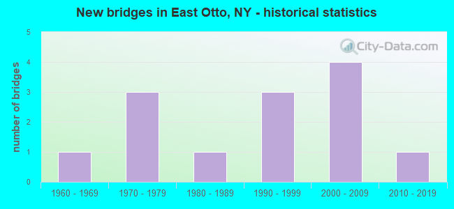
- New bridges - historical statistics
- 11960-1969
- 31970-1979
- 11980-1989
- 31990-1999
- 42000-2009
- 12010-2019

- Reconstructed bridges - Historical Statistics
- 31980-1989
- 11990-1999
- 02000-2009
- 22010-2019

- Bridge Condition - Deck
- 20.0%Very good
- 60.0%Good
- 20.0%Satisfactory

- Bridge Condition - Superstructure
- 20.0%Excellent
- 20.0%Very good
- 50.0%Good
- 10.0%Satisfactory

- Bridge Condition - Substructure
- 20.0%Excellent
- 40.0%Good
- 20.0%Satisfactory
- 20.0%Fair

- Bridge Condition - Channel
- 7.7%Very good
- 23.1%Good
- 38.5%Satisfactory
- 15.4%Fair
- 15.4%Poor

- Bridge Condition - Culverts
- 33.3%Very good
- 66.7%Good
Find on map >> Show street view
Structure Number: 332104, Location: 1.8 MILES NW OF EDDYVILLE (Lat: 42.348719, Lng: -78.785428), Route carried "on" structure: County highway , Year Built: 1990, Year Reconstructed: 2016, Status: Open, Structure Length: 2.56m (8.40ft), Average Daily Traffic: 320 (year 2018), Truck Traffic: 8%, Average Future Daily Traffic: 448 (year 2038), Design Load: HS 20, Features Intersected: MANSFIELD CREEK, Facility Carried by Structure: COUNTY ROAD 13
Minimum Vertical Clearance: 30+ m (98+ ft), Kilometerpoint: 2.735, Lanes on structure: 2, Owner: County Highway Agency, Approaching Roadway Width: 9.4m (30.8ft), Material/Design: Prestressed concrete, Design/Construction: Box Beam or Girders - Multiple, Number Of Spans In Main Unit: 1, Length of Maximum Span: 24.3m (79.7ft), Curb-To-Curb Width: 9.4m (30.8ft), Out-to-Out Width: 10.2m (33.5ft)
Condition: Deck: Very good, Superstructure: Very good, Substructure: Good, Channel: Good, Operating Rating: 94.3 metric tons, Method Used To Determine Operating Rating: Load Factor (LF), Inventory Rating: 37.2 metric tons, Method Used To Determine Inventory Rating: Load Factor (LF), Structural Evaluation: Better than present minimum criteria, Deck Geometry: Equal to present minimum criteria, Waterway Adequacy: Somewhat better than minimum adequacy, Approach Roadway Alignment: Equal to present desirable criteria, Length Of Structure Improvement: 2.56m (8.40ft), Designated Inspection Frequency: Every 24 months, Inspection Date: March 2021, Bridge Improvement Cost: $925,000, Roadway Improvement Cost: $542,000, Total Project Cost: $1,467,000 ( Estimate for 2021), Deck Structure Type: Concrete Cast-file-Place, Wearing Surface/Protective System: Wearing Surface: Integral Concrete
Find on map >> Show street view
Structure Number: 332105, Location: 2.5 MI S OF ASHFORD HLLOW (Lat: 42.368453, Lng: -78.693044), Route carried "on" structure: County highway , Year Built: 1978, Year Reconstructed: 1998, Status: Open, Structure Length: 0.91m (2.99ft), Average Daily Traffic: 101 (year 2017), Truck Traffic: 13%, Average Future Daily Traffic: 141 (year 2037), Design Load: HS 20, Features Intersected: EAST OTTO CREEK, Facility Carried by Structure: ROHR ROAD
Minimum Vertical Clearance: 30+ m (98+ ft), Kilometerpoint: 6.323, Lanes on structure: 2, Owner: County Highway Agency, Approaching Roadway Width: 4.9m (16.1ft), Skew: 3 degrees, Material/Design: Steel, Design/Construction: Stringer/Multi-beam, Number Of Spans In Main Unit: 1, Length of Maximum Span: 8.8m (28.9ft), Curb-To-Curb Width: 8.5m (27.9ft), Out-to-Out Width: 9.1m (29.9ft)
Condition: Deck: Good, Superstructure: Very good, Substructure: Good, Channel: Satisfactory, Operating Rating: 74.4 metric tons, Method Used To Determine Operating Rating: Load Factor (LF), Inventory Rating: 49.0 metric tons, Method Used To Determine Inventory Rating: Load Factor (LF), Structural Evaluation: Better than present minimum criteria, Deck Geometry: Equal to present minimum criteria, Waterway Adequacy: Meets minimum limits, Approach Roadway Alignment: Equal to present desirable criteria, Length Of Structure Improvement: 0.91m (2.99ft), Designated Inspection Frequency: Every 24 months, Inspection Date: July 2020, Bridge Improvement Cost: $932,000, Roadway Improvement Cost: $546,000, Total Project Cost: $1,477,000 ( Estimate for 2021), Deck Structure Type: Concrete Precast Panels, Wearing Surface/Protective System: Wearing Surface: Bituminous, Membrane: Other
Find on map >> Show street view
Structure Number: 332106, Location: 1.5 MI NW OF ASHFORD HLLW (Lat: 42.424456, Lng: -78.698444), Route carried "on" structure: County highway , Year Built: 2001, Status: Open, Structure Length: 1.40m (4.59ft), Average Daily Traffic: 72 (year 2018), Truck Traffic: 14%, Average Future Daily Traffic: 101 (year 2038), Design Load: HS 25 or greater, Features Intersected: CONNOISARAULY CRK, Facility Carried by Structure: COUNTY ROAD 12
Minimum Vertical Clearance: 30+ m (98+ ft), Kilometerpoint: 22.655, Lanes on structure: 2, Owner: County Highway Agency, Approaching Roadway Width: 8.5m (27.9ft), Skew: 1 degrees, Material/Design: Prestressed concrete, Design/Construction: Box Beam or Girders - Multiple, Number Of Spans In Main Unit: 1, Length of Maximum Span: 13.1m (43.0ft), Curb-To-Curb Width: 9.0m (29.5ft), Out-to-Out Width: 10.1m (33.1ft)
Condition: Deck: Good, Superstructure: Excellent, Substructure: Excellent, Channel: Satisfactory, Operating Rating: 67.4 metric tons, Method Used To Determine Operating Rating: Load and Resistance Factor Rating (LRFR) rating reported by rating factor(RF) method using HL-93 loadings, Inventory Rating: 52.2 metric tons, Method Used To Determine Inventory Rating: Load and Resistance Factor Rating (LRFR) rating reported by rating factor(RF) method using HL-93 loadings, Structural Evaluation: Superior to present desirable criteria, Deck Geometry: Better than present minimum criteria, Waterway Adequacy: Meets minimum limits, Approach Roadway Alignment: Better than present minimum criteria, Length Of Structure Improvement: 1.40m (4.59ft), Designated Inspection Frequency: Every 24 months, Inspection Date: April 2021, Bridge Improvement Cost: $451,000, Roadway Improvement Cost: $264,000, Total Project Cost: $715,000 ( Estimate for 2021), Deck Structure Type: Concrete Cast-file-Place, Wearing Surface/Protective System: Wearing Surface: Integral Concrete, Deck Protection: Epoxy Coated Reinforcing
Find on map >> Show street view
Structure Number: 332107, Location: .1 MILE N OF EAST OTTO (Lat: 42.392011, Lng: -78.755006), Route carried "on" structure: County highway , Year Built: 2001, Status: Open, Structure Length: 1.37m (4.49ft), Average Daily Traffic: 1,594 (year 2020), Truck Traffic: 5%, Average Future Daily Traffic: 1,609 (year 2040), Design Load: HS 20, Features Intersected: SB CATTARAUGUS CK, Facility Carried by Structure: COUNTY ROAD 12
Minimum Vertical Clearance: 30+ m (98+ ft), Kilometerpoint: 13.435, Lanes on structure: 2, Owner: County Highway Agency, Approaching Roadway Width: 11.6m (38.1ft), Skew: 1 degrees, Material/Design: Prestressed concrete, Design/Construction: Box Beam or Girders - Multiple, Number Of Spans In Main Unit: 1, Length of Maximum Span: 13.1m (43.0ft), Curb or Sidewalk Widths: Left: 1.5m (4.9ft), Right: 0.0m, Curb-To-Curb Width: 9.9m (32.5ft), Out-to-Out Width: 12.5m (41.0ft)
Condition: Deck: Good, Superstructure: Good, Substructure: Good, Channel: Satisfactory, Operating Rating: 82.6 metric tons, Method Used To Determine Operating Rating: Load Factor (LF), Inventory Rating: 49.0 metric tons, Method Used To Determine Inventory Rating: Load Factor (LF), Structural Evaluation: Better than present minimum criteria, Deck Geometry: Somewhat better than minimum adequacy, Waterway Adequacy: Meets minimum limits, Approach Roadway Alignment: Equal to present desirable criteria, Length Of Structure Improvement: 1.37m (4.49ft), Designated Inspection Frequency: Every 24 months, Inspection Date: July 2021, Bridge Improvement Cost: $1,252,000, Roadway Improvement Cost: $733,000, Total Project Cost: $1,985,000 ( Estimate for 2021), Deck Structure Type: Concrete Cast-file-Place, Wearing Surface/Protective System: Wearing Surface: Integral Concrete
Find on map >> Show street view
Structure Number: 332108, Location: 1 MILE WEST OF EAST OTTO (Lat: 42.390253, Lng: -78.775458), Route carried "on" structure: County highway , Year Built: 1961, Year Reconstructed: 1991, Status: Open, Structure Length: 1.19m (3.90ft), Average Daily Traffic: 404 (year 2017), Truck Traffic: 4%, Average Future Daily Traffic: 566 (year 2037), Design Load: H 20, Features Intersected: SB CATTARAUGUS CK, Facility Carried by Structure: COUNTY ROAD 68
Minimum Vertical Clearance: 30+ m (98+ ft), Kilometerpoint: 4.666, Lanes on structure: 2, Owner: County Highway Agency, Approaching Roadway Width: 5.5m (18.0ft), Material/Design: Steel, Design/Construction: Stringer/Multi-beam, Number Of Spans In Main Unit: 1, Length of Maximum Span: 11.5m (37.7ft), Curb-To-Curb Width: 8.6m (28.2ft), Out-to-Out Width: 9.1m (29.9ft)
Condition: Deck: Satisfactory, Superstructure: Good, Substructure: Fair, Channel: Poor, Operating Rating: 64.8 metric tons, Method Used To Determine Operating Rating: Load and Resistance Factor Rating (LRFR) rating reported by rating factor(RF) method using HL-93 loadings, Inventory Rating: 49.9 metric tons, Method Used To Determine Inventory Rating: Load and Resistance Factor Rating (LRFR) rating reported by rating factor(RF) method using HL-93 loadings, Structural Evaluation: Somewhat better than minimum adequacy, Deck Geometry: Somewhat better than minimum adequacy, Waterway Adequacy: Meets minimum limits, Approach Roadway Alignment: Equal to present desirable criteria, Length Of Structure Improvement: 1.18m (3.87ft), Designated Inspection Frequency: Every 24 months, Inspection Date: May 2021, Bridge Improvement Cost: $1,103,000, Roadway Improvement Cost: $646,000, Total Project Cost: $1,749,000 ( Estimate for 2021), Deck Structure Type: Wood or Timber, Wearing Surface/Protective System: Wearing Surface: Bituminous, Membrane: Other
Find on map >> Show street view
Structure Number: 332109, Location: 2.6 MILES SE OF EAST OTTO (Lat: 42.372725, Lng: -78.710442), Route carried "on" structure: County highway , Year Built: 1976, Year Reconstructed: 1991, Status: Open, Structure Length: 0.91m (2.99ft), Average Daily Traffic: 101 (year 2017), Truck Traffic: 13%, Average Future Daily Traffic: 141 (year 2037), Design Load: HS 20, Features Intersected: EAST OTTO CREEK, Facility Carried by Structure: COUNTY ROAD 75
Minimum Vertical Clearance: 30+ m (98+ ft), Kilometerpoint: 4.779, Lanes on structure: 2, Owner: County Highway Agency, Approaching Roadway Width: 5.5m (18.0ft), Skew: 3 degrees, Material/Design: Steel, Design/Construction: Stringer/Multi-beam, Number Of Spans In Main Unit: 1, Length of Maximum Span: 8.8m (28.9ft), Curb-To-Curb Width: 8.4m (27.6ft), Out-to-Out Width: 9.0m (29.5ft)
Condition: Deck: Satisfactory, Superstructure: Good, Substructure: Fair, Channel: Good, Operating Rating: 90.7 metric tons, Method Used To Determine Operating Rating: Allowable Stress (AS), Inventory Rating: 54.4 metric tons, Method Used To Determine Inventory Rating: Allowable Stress (AS), Structural Evaluation: Somewhat better than minimum adequacy, Deck Geometry: Somewhat better than minimum adequacy, Waterway Adequacy: Somewhat better than minimum adequacy, Approach Roadway Alignment: Equal to present desirable criteria, Length Of Structure Improvement: 0.91m (2.99ft), Designated Inspection Frequency: Every 24 months, Inspection Date: June 2021, Bridge Improvement Cost: $1,608,000, Roadway Improvement Cost: $942,000, Total Project Cost: $2,550,000 ( Estimate for 2021), Deck Structure Type: Wood or Timber, Wearing Surface/Protective System: Wearing Surface: Bituminous, Membrane: Other
Find on map >> Show street view
Structure Number: 33211, Location: .3 MILE EAST OF EAST OTTO (Lat: 42.389658, Lng: -78.748561), Route carried "on" structure: County highway , Year Built: 1983, Year Reconstructed: 1994, Status: Open, Structure Length: 1.83m (6.00ft), Average Daily Traffic: 375 (year 2020), Truck Traffic: 8%, Average Future Daily Traffic: 525 (year 2040), Design Load: H 20, Features Intersected: EAST OTTO CREEK, Facility Carried by Structure: EAST FLATS ROAD
Minimum Vertical Clearance: 30+ m (98+ ft), Kilometerpoint: 0.531, Lanes on structure: 2, Owner: County Highway Agency, Approaching Roadway Width: 5.5m (18.0ft), Skew: 3 degrees, Material/Design: Steel, Design/Construction: Girder and Floorbeam System, Number Of Spans In Main Unit: 1, Length of Maximum Span: 17.3m (56.8ft), Curb-To-Curb Width: 8.1m (26.6ft), Out-to-Out Width: 8.4m (27.6ft)
Condition: Deck: Good, Superstructure: Good, Substructure: Satisfactory, Channel: Poor, Operating Rating: 53.5 metric tons, Method Used To Determine Operating Rating: Load Factor (LF), Inventory Rating: 37.2 metric tons, Method Used To Determine Inventory Rating: Load Factor (LF), Structural Evaluation: Equal to present minimum criteria, Deck Geometry: Somewhat better than minimum adequacy, Waterway Adequacy: Meets minimum limits, Approach Roadway Alignment: Equal to present minimum criteria, Length Of Structure Improvement: 1.82m (5.97ft), Designated Inspection Frequency: Every 24 months, Critical Feature Inspection Frequency: Every 24 months, Inspection Date: July 2020, Critical Feature Inspection Date: July 2020, Bridge Improvement Cost: $1,257,000, Roadway Improvement Cost: $736,000, Total Project Cost: $1,993,000 ( Estimate for 2021), Deck Structure Type: Wood or Timber, Wearing Surface/Protective System: Wearing Surface: Bituminous
Find on map >> Show street view
Structure Number: 332111, Location: 1.9 MI SW OF EAST OTTO (Lat: 42.380664, Lng: -78.789608), Route carried "on" structure: Other road , Year Built: 2001, Status: Open, Structure Length: 1.16m (3.81ft), Average Daily Traffic: 74 (year 2017), Truck Traffic: 7%, Average Future Daily Traffic: 104 (year 2037), Design Load: HS 25 or greater, Features Intersected: S BR CATTARGUS CK, Facility Carried by Structure: COLVIN ROAD
Minimum Vertical Clearance: 30+ m (98+ ft), Kilometerpoint: 0.853, Lanes on structure: 2, Owner: County Highway Agency, Approaching Roadway Width: 7.9m (25.9ft), Material/Design: Concrete, Design/Construction: Culvert, Number Of Spans In Main Unit: 1, Length of Maximum Span: 11.3m (37.1ft)
Condition: Channel: Satisfactory, Culverts: Good, Operating Rating: 80.6 metric tons, Method Used To Determine Operating Rating: Field evaluation and documented engineering judgment, Inventory Rating: 40.8 metric tons, Method Used To Determine Inventory Rating: Field evaluation and documented engineering judgment, Structural Evaluation: Better than present minimum criteria, Waterway Adequacy: Equal to present minimum criteria, Approach Roadway Alignment: Equal to present desirable criteria, Length Of Structure Improvement: 1.15m (3.77ft), Designated Inspection Frequency: Every 24 months, Inspection Date: May 2021, Bridge Improvement Cost: $254,000, Roadway Improvement Cost: $148,000, Total Project Cost: $402,000 ( Estimate for 2021)
Find on map >> Show street view
Structure Number: 332112, Location: 2 MILES SE OF EAST OTTO (Lat: 42.378919, Lng: -78.719436), Route carried "on" structure: Other road , Year Built: 2013, Status: Open, Structure Length: 0.88m (2.89ft), Average Daily Traffic: 51 (year 2019), Truck Traffic: 2%, Average Future Daily Traffic: 71 (year 2039), Design Load: HS 25 or greater, Features Intersected: EAST OTTO CREEK, Facility Carried by Structure: MEYER HILL ROAD
Minimum Vertical Clearance: 30+ m (98+ ft), Kilometerpoint: 3.331, Lanes on structure: 2, Owner: County Highway Agency, Approaching Roadway Width: 7.3m (24.0ft), Skew: 2 degrees, Material/Design: Steel, Design/Construction: Stringer/Multi-beam, Number Of Spans In Main Unit: 1, Length of Maximum Span: 8.5m (27.9ft), Curb-To-Curb Width: 8.0m (26.2ft), Out-to-Out Width: 8.8m (28.9ft)
Condition: Deck: Good, Superstructure: Excellent, Substructure: Excellent, Channel: Very good, Operating Rating: 81.6 metric tons, Method Used To Determine Operating Rating: Allowable Stress (AS), Inventory Rating: 56.2 metric tons, Method Used To Determine Inventory Rating: Allowable Stress (AS), Structural Evaluation: Superior to present desirable criteria, Deck Geometry: Equal to present minimum criteria, Waterway Adequacy: Equal to present minimum criteria, Approach Roadway Alignment: Equal to present desirable criteria, Length Of Structure Improvement: 0.88m (2.89ft), Designated Inspection Frequency: Every 24 months, Inspection Date: June 2020, Bridge Improvement Cost: $2,263,000, Roadway Improvement Cost: $1,325,000, Total Project Cost: $3,588,000 ( Estimate for 2021), Deck Structure Type: Concrete Precast Panels, Wearing Surface/Protective System: Wearing Surface: Latex Concrete
Find on map >> Show street view
Structure Number: 332113, Location: 1.6 MILES SE OF EAST OTTO (Lat: 42.383069, Lng: -78.724636), Route carried "on" structure: Other road , Year Built: 2007, Status: Open, Structure Length: 1.19m (3.90ft), Average Daily Traffic: 228 (year 2020), Truck Traffic: 5%, Average Future Daily Traffic: 319 (year 2040), Design Load: HS 25 or greater, Features Intersected: EAST OTTO CREEK, Facility Carried by Structure: CRUMB HILL ROAD
Minimum Vertical Clearance: 30+ m (98+ ft), Kilometerpoint: 4.216, Lanes on structure: 2, Owner: County Highway Agency, Approaching Roadway Width: 6.1m (20.0ft), Skew: 2 degrees, Material/Design: Concrete, Design/Construction: Culvert, Number Of Spans In Main Unit: 1, Length of Maximum Span: 11.3m (37.1ft)
Condition: Channel: Satisfactory, Culverts: Very good, Operating Rating: 80.6 metric tons, Method Used To Determine Operating Rating: Field evaluation and documented engineering judgment, Inventory Rating: 40.8 metric tons, Method Used To Determine Inventory Rating: Field evaluation and documented engineering judgment, Structural Evaluation: Equal to present desirable criteria, Waterway Adequacy: Somewhat better than minimum adequacy, Approach Roadway Alignment: Equal to present desirable criteria, Length Of Structure Improvement: 1.18m (3.87ft), Designated Inspection Frequency: Every 24 months, Inspection Date: September 2021, Bridge Improvement Cost: $200,000, Roadway Improvement Cost: $117,000, Total Project Cost: $318,000 ( Estimate for 2021)
Find on map >> Show street view
Structure Number: 332114, Location: .8 MILE WEST OF EAST OTTO (Lat: 42.393028, Lng: -78.770381), Route carried "on" structure: Other road , Year Built: 1997, Status: Open, Structure Length: 1.62m (5.31ft), Average Daily Traffic: 218 (year 2017), Truck Traffic: 3%, Average Future Daily Traffic: 305 (year 2037), Design Load: HS 25 or greater, Features Intersected: SB CATTARAUGUS CK, Facility Carried by Structure: UTLEY ROAD
Minimum Vertical Clearance: 30+ m (98+ ft), Kilometerpoint: 0.322, Lanes on structure: 2, Owner: County Highway Agency, Approaching Roadway Width: 7.9m (25.9ft), Skew: 1 degrees, Material/Design: Prestressed concrete, Design/Construction: Box Beam or Girders - Multiple, Number Of Spans In Main Unit: 1, Length of Maximum Span: 14.9m (48.9ft), Curb-To-Curb Width: 7.9m (25.9ft), Out-to-Out Width: 8.8m (28.9ft)
Condition: Deck: Good, Superstructure: Good, Substructure: Good, Channel: Fair, Operating Rating: 76.5 metric tons, Method Used To Determine Operating Rating: Load and Resistance Factor Rating (LRFR) rating reported by rating factor(RF) method using HL-93 loadings, Inventory Rating: 59.0 metric tons, Method Used To Determine Inventory Rating: Load and Resistance Factor Rating (LRFR) rating reported by rating factor(RF) method using HL-93 loadings, Structural Evaluation: Better than present minimum criteria, Deck Geometry: Somewhat better than minimum adequacy, Waterway Adequacy: Somewhat better than minimum adequacy, Approach Roadway Alignment: Equal to present desirable criteria, Length Of Structure Improvement: 1.61m (5.28ft), Designated Inspection Frequency: Every 24 months, Inspection Date: May 2021, Bridge Improvement Cost: $296,000, Roadway Improvement Cost: $173,000, Total Project Cost: $469,000 ( Estimate for 2021), Deck Structure Type: Concrete Cast-file-Place, Wearing Surface/Protective System: Wearing Surface: Integral Concrete, Deck Protection: Epoxy Coated Reinforcing
Find on map >> Show street view
Structure Number: 332115, Location: 2.6 MILES N OF BROOKLYN (Lat: 42.470586, Lng: -78.748061), Route carried "on" structure: Other road , Year Built: 1972, Year Reconstructed: 2019, Status: Posted for load-capacity, Structure Length: 1.80m (5.91ft), Average Daily Traffic: 128 (year 2018), Truck Traffic: 2%, Average Future Daily Traffic: 179 (year 2038), Design Load: HS 20, Features Intersected: CONNOISARAULEY CR, Facility Carried by Structure: HAMMOND HILL ROAD
Minimum Vertical Clearance: 30+ m (98+ ft), Kilometerpoint: 4.441, Lanes on structure: 2, Owner: County Highway Agency, Approaching Roadway Width: 6.1m (20.0ft), Material/Design: Steel, Design/Construction: Girder and Floorbeam System, Number Of Spans In Main Unit: 1, Length of Maximum Span: 17.6m (57.7ft), Curb-To-Curb Width: 7.3m (24.0ft), Out-to-Out Width: 7.4m (24.3ft)
Condition: Deck: Very good, Superstructure: Satisfactory, Substructure: Satisfactory, Channel: Fair, Operating Rating: 26.2 metric tons, Method Used To Determine Operating Rating: Load and Resistance Factor Rating (LRFR) rating reported by rating factor(RF) method using HL-93 loadings, Inventory Rating: 20.1 metric tons, Method Used To Determine Inventory Rating: Load and Resistance Factor Rating (LRFR) rating reported by rating factor(RF) method using HL-93 loadings, Structural Evaluation: Somewhat better than minimum adequacy, Deck Geometry: Somewhat better than minimum adequacy, Waterway Adequacy: Meets minimum limits, Approach Roadway Alignment: Better than present minimum criteria, Length Of Structure Improvement: 1.79m (5.87ft), Designated Inspection Frequency: Every 24 months, Critical Feature Inspection Frequency: Every 24 months, Inspection Date: May 2021, Critical Feature Inspection Date: May 2021, Bridge Improvement Cost: $890,000, Roadway Improvement Cost: $521,000, Total Project Cost: $1,411,000 ( Estimate for 2021), Deck Structure Type: Open Grating, Wearing Surface/Protective System: Wearing Surface: Other
Find on map >> Show street view
Structure Number: 332116, Location: 1.9 MI NE OF BROOKLYN (Lat: 42.442217, Lng: -78.712942), Route carried "on" structure: Other road , Year Built: 1999, Status: Open, Structure Length: 1.04m (3.41ft), Average Daily Traffic: 2,006 (year 2018), Truck Traffic: 5%, Average Future Daily Traffic: 2,026 (year 2040), Design Load: HS 25 or greater, Features Intersected: CONNOISARAULEY CR, Facility Carried by Structure: CONNOISARAULEY RD
Minimum Vertical Clearance: 30+ m (98+ ft), Kilometerpoint: 1.480, Lanes on structure: 2, Owner: County Highway Agency, Approaching Roadway Width: 6.7m (22.0ft), Material/Design: Concrete, Design/Construction: Culvert, Number Of Spans In Main Unit: 1, Length of Maximum Span: 10.0m (32.8ft), Curb-To-Curb Width: 9.5m (31.2ft), Out-to-Out Width: 10.4m (34.1ft)
Condition: Channel: Good, Culverts: Good, Operating Rating: 79.7 metric tons, Method Used To Determine Operating Rating: Field evaluation and documented engineering judgment, Inventory Rating: 40.8 metric tons, Method Used To Determine Inventory Rating: Field evaluation and documented engineering judgment, Structural Evaluation: Better than present minimum criteria, Deck Geometry: Meets minimum limits, Waterway Adequacy: Somewhat better than minimum adequacy, Approach Roadway Alignment: Meets minimum limits, Length Of Structure Improvement: 1.03m (3.38ft), Designated Inspection Frequency: Every 24 months, Inspection Date: June 2021, Bridge Improvement Cost: $585,000, Roadway Improvement Cost: $343,000, Total Project Cost: $928,000 ( Estimate for 2021)