Bridge Statistics for East Highland Park, Virginia (VA)
Condition, Traffic, Stress, Structural Evaluation, Project Costs
- National Bridge Inventory (NBI) Statistics
- 11Number of bridges
- 89ft / 27.1mTotal length
- $1,256,000Total costs
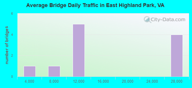
- 159,058Total average daily traffic
- 3,118Total average daily truck traffic
- 183,486Total future (year 2025) average daily traffic
- National Bridge Inventory (NBI) Registered Bridges for East Highland Park
- No street view available for this location
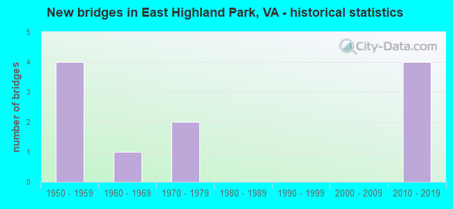
- New bridges - historical statistics
- 41950-1959
- 11960-1969
- 21970-1979
- 42010-2019
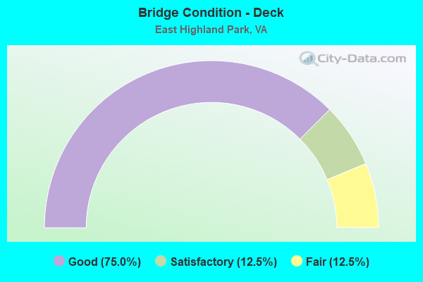
- Bridge Condition - Deck
- 75.0%Good
- 12.5%Satisfactory
- 12.5%Fair
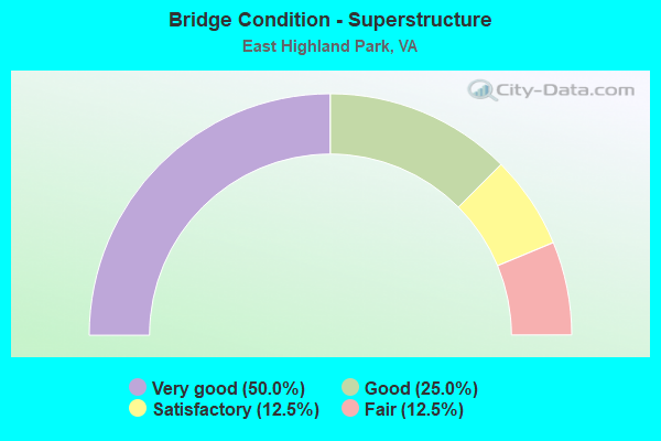
- Bridge Condition - Superstructure
- 50.0%Very good
- 25.0%Good
- 12.5%Satisfactory
- 12.5%Fair
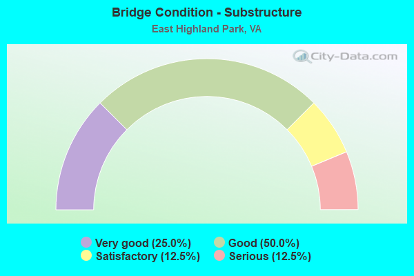
- Bridge Condition - Substructure
- 25.0%Very good
- 50.0%Good
- 12.5%Satisfactory
- 12.5%Serious
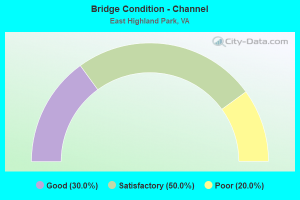
- Bridge Condition - Channel
- 30.0%Good
- 50.0%Satisfactory
- 20.0%Poor
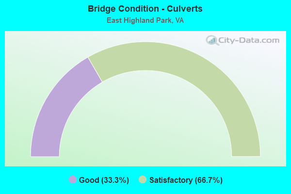
- Bridge Condition - Culverts
- 33.3%Good
- 66.7%Satisfactory
Find on map >> Show street view
Structure Number: 9491, Location: 0.0 TO HENRICO CO LINE (Lat: 37.576736, Lng: -77.334000), Route carried "on" structure: County highway 615, Year Built: 1956, Year Reconstructed: 2012, Status: Open, Structure Length: 4.82m (15.81ft), Average Daily Traffic: 10,795 (year 2020), Truck Traffic: 2%, Average Future Daily Traffic: 15,113 (year 2040), Design Load: HS 20+Mod, Features Intersected: CHICKAHOMINY RIVER, Facility Carried by Structure: CREIGHTON ROAD
Minimum Vertical Clearance: 30+ m (98+ ft), Kilometerpoint: 0.016, Lanes on structure: 2, Owner: State Highway Agency, Approaching Roadway Width: 7.9m (25.9ft), Material/Design: Prestressed concrete, Design/Construction: Slab, Number Of Spans In Main Unit: 3, Length of Maximum Span: 15.9m (52.2ft), Curb-To-Curb Width: 7.5m (24.6ft), Out-to-Out Width: 8.3m (27.2ft)
Condition: Deck: Good, Superstructure: Very good, Substructure: Good, Channel: Satisfactory, Operating Rating: 62.9 metric tons, Method Used To Determine Operating Rating: Load and Resistance Factor (LRFR), Inventory Rating: 44.8 metric tons, Method Used To Determine Inventory Rating: Load and Resistance Factor (LRFR), Structural Evaluation: Better than present minimum criteria, Deck Geometry: High priority of replacement, Waterway Adequacy: Equal to present minimum criteria, Approach Roadway Alignment: Equal to present minimum criteria, Length Of Structure Improvement: 4.82m (15.81ft), Designated Inspection Frequency: Every 24 months, Underwater Inspection Frequency: Every 60 months, Inspection Date: December 2020, Underwater Inspection Date: July 2021, Bridge Improvement Cost: $310,000, Roadway Improvement Cost: $90,000, Total Project Cost: $488,000, Deck Structure Type: Other, Wearing Surface/Protective System: Wearing Surface: Bituminous, Membrane: Preformed Fabric, Deck Protection: Other
Find on map >> Show street view
Structure Number: 9635, Location: 0.20 TO CAROLINA AVENUE (Lat: 37.584853, Lng: -77.411731), Route carried "on" structure: County highway , Year Built: 1963, Status: Open, Structure Length: 4.75m (15.58ft), Average Daily Traffic: 27,201 (year 2020), Truck Traffic: 2%, Average Future Daily Traffic: 34,103 (year 2040), Design Load: HS 20, Features Intersected: CSX RAILWAY, Facility Carried by Structure: LABURNUM AVENUE
Minimum Vertical Clearance: 30+ m (98+ ft), Kilometerpoint: 16.830, Lanes on structure: 4, Base Highway Network: Yes, Owner: County Highway Agency, Approaching Roadway Width: 15.8m (51.8ft), Skew: 20 degrees, Material/Design: Steel, Design/Construction: Stringer/Multi-beam, Number Of Spans In Main Unit: 3, Length of Maximum Span: 21.0m (68.9ft), Curb or Sidewalk Widths: Left: 0.2m (0.7ft), Right: 0.2m (0.7ft), Curb-To-Curb Width: 15.8m (51.8ft), Out-to-Out Width: 21.0m (68.9ft)
Condition: Deck: Satisfactory, Superstructure: Good, Substructure: Good, Operating Rating: 51.7 metric tons, Method Used To Determine Operating Rating: Load Factor (LF), Inventory Rating: 30.8 metric tons, Method Used To Determine Inventory Rating: Load Factor (LF), Structural Evaluation: Better than present minimum criteria, Deck Geometry: Meets minimum limits, Underclear: Superior to present desirable criteria, Approach Roadway Alignment: Equal to present minimum criteria, Length Of Structure Improvement: 4.75m (15.58ft), Designated Inspection Frequency: Every 24 months, Inspection Date: May 2021, Bridge Improvement Cost: $550,000, Roadway Improvement Cost: $90,000, Total Project Cost: $768,000, Deck Structure Type: Concrete Cast-file-Place, Wearing Surface/Protective System: Wearing Surface: Epoxy Overlay, Membrane: Epoxy
Find on map >> Show street view
Structure Number: 9653, Location: .70 LABURNUM .88 RICH HEN (Lat: 37.599472, Lng: -77.418139), Route carried "on" structure: County highway , Year Built: 1971, Status: Open, Structure Length: 0.85m (2.79ft), Average Daily Traffic: 9,197 (year 2020), Truck Traffic: 4%, Average Future Daily Traffic: 11,821 (year 2040), Design Load: HS 20, Features Intersected: HORSESWAMP CREEK, Facility Carried by Structure: CAROLINA AVENUE
Minimum Vertical Clearance: 30+ m (98+ ft), Kilometerpoint: 1.126, Lanes on structure: 2, Owner: County Highway Agency, Approaching Roadway Width: 8.2m (26.9ft), Skew: 1 degrees, Material/Design: Concrete, Design/Construction: Culvert, Number Of Spans In Main Unit: 3, Length of Maximum Span: 2.4m (7.9ft)
Condition: Channel: Poor, Culverts: Satisfactory, Operating Rating: 89.8 metric tons, Method Used To Determine Operating Rating: Load and Resistance Factor (LRFR), Inventory Rating: 89.8 metric tons, Method Used To Determine Inventory Rating: Load and Resistance Factor (LRFR), Structural Evaluation: Equal to present minimum criteria, Waterway Adequacy: Superior to present desirable criteria, Approach Roadway Alignment: Equal to present desirable criteria, Designated Inspection Frequency: Every 24 months, Inspection Date: July 2020
Find on map >> Show street view
Structure Number: 28896, Location: 0.0 HANOVER/HENRICO CO LN (Lat: 37.594900, Lng: -77.382900), Route carried "on" structure: US 360, Year Built: 2014, Status: Open, Structure Length: 6.63m (21.75ft), Average Daily Traffic: 26,545 (year 2020), Truck Traffic: 2%, Average Future Daily Traffic: 29,200 (year 2040), Design Load: HS 20+Mod, Features Intersected: CHICKAHOMINY RIVER, Facility Carried by Structure: MECHANICSVILLE TPK
Minimum Vertical Clearance: 30.18m (99.02ft), Kilometerpoint: 0.000, Lanes on structure: 6, Base Highway Network: Yes, Owner: State Highway Agency, Approaching Roadway Width: 29.0m (95.1ft), Skew: 20 degrees, Material/Design: Prestressed concrete, Design/Construction: Slab, Number Of Spans In Main Unit: 5, Length of Maximum Span: 14.0m (45.9ft), Curb-To-Curb Width: 34.6m (113.5ft), Out-to-Out Width: 35.4m (116.1ft)
Condition: Deck: Good, Superstructure: Very good, Substructure: Good, Channel: Good, Operating Rating: 99.6 metric tons, Method Used To Determine Operating Rating: Load and Resistance Factor (LRFR), Inventory Rating: 71.1 metric tons, Method Used To Determine Inventory Rating: Load and Resistance Factor (LRFR), Structural Evaluation: Better than present minimum criteria, Deck Geometry: Superior to present desirable criteria, Waterway Adequacy: Equal to present desirable criteria, Approach Roadway Alignment: Equal to present minimum criteria, Designated Inspection Frequency: Every 24 months, Underwater Inspection Frequency: Every 60 months, Inspection Date: May 2021, Underwater Inspection Date: March 2017, Deck Structure Type: Concrete Cast-file-Place, Wearing Surface/Protective System: Wearing Surface: Monolithic Concrete, Deck Protection: Other Coated Reinforcing
Find on map >> Show street view
Structure Number: 28898, Location: 0.75 FR SPRINGDALE ROAD (Lat: 37.592736, Lng: -77.384661), Route carried "on" structure: US 360, Year Built: 2014, Status: Open, Structure Length: 2.62m (8.60ft), Average Daily Traffic: 26,545 (year 2020), Truck Traffic: 2%, Average Future Daily Traffic: 26,980 (year 2040), Design Load: HS 20+Mod, Features Intersected: BR CHICKAHOMINY RIVER #2, Facility Carried by Structure: MECHANICSVILLE TPK
Minimum Vertical Clearance: 30.45m (99.90ft), Kilometerpoint: 0.000, Lanes on structure: 4, Base Highway Network: Yes, Owner: State Highway Agency, Approaching Roadway Width: 28.7m (94.2ft), Skew: 20 degrees, Material/Design: Prestressed concrete continuous, Design/Construction: Box Beam or Girders - Multiple, Number Of Spans In Main Unit: 1, Length of Maximum Span: 12.4m (40.7ft), Curb-To-Curb Width: 33.5m (109.9ft), Out-to-Out Width: 34.3m (112.5ft)
Condition: Deck: Good, Superstructure: Very good, Substructure: Very good, Channel: Satisfactory, Operating Rating: 93.4 metric tons, Method Used To Determine Operating Rating: Load and Resistance Factor (LRFR), Inventory Rating: 50.8 metric tons, Method Used To Determine Inventory Rating: Load and Resistance Factor (LRFR), Structural Evaluation: Equal to present desirable criteria, Deck Geometry: Superior to present desirable criteria, Waterway Adequacy: Equal to present desirable criteria, Approach Roadway Alignment: Equal to present desirable criteria, Designated Inspection Frequency: Every 24 months, Underwater Inspection Frequency: Every 60 months, Inspection Date: May 2021, Underwater Inspection Date: April 2020, Deck Structure Type: Concrete Cast-file-Place, Wearing Surface/Protective System: Wearing Surface: Monolithic Concrete, Deck Protection: Epoxy Coated Reinforcing
Find on map >> Show street view
Structure Number: 28899, Location: 0.65 FR SPRINGDALE ROAD (Lat: 37.591500, Lng: -77.385500), Route carried "on" structure: US 360, Year Built: 2014, Status: Open, Structure Length: 2.62m (8.60ft), Average Daily Traffic: 26,545 (year 2020), Truck Traffic: 2%, Average Future Daily Traffic: 26,980 (year 2040), Design Load: HS 20+Mod, Features Intersected: BR CHICKAHOMINY RIVER #1, Facility Carried by Structure: MECHANICSVILLE TPK
Minimum Vertical Clearance: 30+ m (98+ ft), Kilometerpoint: 0.000, Lanes on structure: 4, Owner: State Highway Agency, Approaching Roadway Width: 11.0m (36.1ft), Skew: 20 degrees, Material/Design: Prestressed concrete continuous, Design/Construction: Slab, Number Of Spans In Main Unit: 2, Length of Maximum Span: 12.7m (41.7ft), Curb-To-Curb Width: 33.5m (109.9ft), Out-to-Out Width: 34.4m (112.9ft)
Condition: Deck: Good, Superstructure: Very good, Substructure: Very good, Channel: Good, Operating Rating: 82.5 metric tons, Method Used To Determine Operating Rating: Load and Resistance Factor (LRFR), Inventory Rating: 63.6 metric tons, Method Used To Determine Inventory Rating: Load and Resistance Factor (LRFR), Structural Evaluation: Equal to present desirable criteria, Deck Geometry: Superior to present desirable criteria, Waterway Adequacy: Equal to present desirable criteria, Approach Roadway Alignment: Equal to present desirable criteria, Designated Inspection Frequency: Every 24 months, Underwater Inspection Frequency: Every 60 months, Inspection Date: May 2021, Underwater Inspection Date: April 2020, Deck Structure Type: Concrete Cast-file-Place, Wearing Surface/Protective System: Deck Protection: Epoxy Coated Reinforcing
Find on map >> Show street view
Structure Number: 30661, Location: 0.85 MI W OF N. LABUR AVE (Lat: 37.551500, Lng: -77.387111), Route carried "on" structure: County highway 7618, Year Built: 2015, Status: Open, Structure Length: 1.04m (3.41ft), Average Daily Traffic: 4,380 (year 2020), Truck Traffic: 1%, Average Future Daily Traffic: 6,132 (year 2040), Design Load: HS 20, Features Intersected: STONY RUN, Facility Carried by Structure: CREIGHTON ROAD
Minimum Vertical Clearance: 30+ m (98+ ft), Kilometerpoint: 0.000, Lanes on structure: 2, Owner: County Highway Agency, Approaching Roadway Width: 12.2m (40.0ft), Skew: 1 degrees, Material/Design: Concrete, Design/Construction: Arch - Deck, Number Of Spans In Main Unit: 1, Length of Maximum Span: 9.8m (32.2ft), Curb-To-Curb Width: 12.2m (40.0ft), Out-to-Out Width: 12.2m (40.0ft)
Condition: Deck: Good, Superstructure: Good, Substructure: Good, Channel: Good, Operating Rating: 89.8 metric tons, Method Used To Determine Operating Rating: Load and Resistance Factor (LRFR), Inventory Rating: 84.5 metric tons, Method Used To Determine Inventory Rating: Load and Resistance Factor (LRFR), Structural Evaluation: Better than present minimum criteria, Deck Geometry: Equal to present minimum criteria, Waterway Adequacy: Equal to present minimum criteria, Approach Roadway Alignment: Equal to present desirable criteria, Designated Inspection Frequency: Every 24 months, Inspection Date: April 2021
Find on map >> Show street view
Structure Number: 30695, Location: .05 FR SNGWDS TO .05 PERS (Lat: 37.551667, Lng: -77.386667), Route carried "on" structure: County highway , Year Built: 1978, Status: Open, Structure Length: 0.79m (2.59ft), Average Daily Traffic: 250 (year 2015), Average Future Daily Traffic: 300 (year 2025), Design Load: H 20, Features Intersected: STONEY RUN, Facility Carried by Structure: BROOKMONT DRIVE
Minimum Vertical Clearance: 4.24m (13.91ft), Kilometerpoint: 0.000, Lanes on structure: 2, Owner: County Highway Agency, Approaching Roadway Width: 11.0m (36.1ft), Material/Design: Concrete, Design/Construction: Culvert, Number Of Spans In Main Unit: 3, Length of Maximum Span: 2.4m (7.9ft)
Condition: Channel: Satisfactory, Culverts: Good, Operating Rating: 54.4 metric tons, Method Used To Determine Operating Rating: Field evaluation and documented engineering judgment, Inventory Rating: 32.7 metric tons, Method Used To Determine Inventory Rating: Field evaluation and documented engineering judgment, Structural Evaluation: Better than present minimum criteria, Waterway Adequacy: Equal to present desirable criteria, Approach Roadway Alignment: Equal to present desirable criteria, Designated Inspection Frequency: Every 24 months, Inspection Date: October 2021
Find on map >> Show street view
Structure Number: 31417, Location: 1.07AzaleaAve 1.36Rt638 (Lat: 37.611114, Lng: -77.407672), Route carried "on" structure: County highway 76090, Year Built: 1953, Status: Open, Structure Length: 0.99m (3.25ft), Average Daily Traffic: 8,300 (year 2019), Truck Traffic: 2%, Average Future Daily Traffic: 9,830 (year 2036), Design Load: HS 20, Features Intersected: Upham Brook, Facility Carried by Structure: Rte 627
Minimum Vertical Clearance: 30+ m (98+ ft), Kilometerpoint: 0.000, Lanes on structure: 2, Owner: County Highway Agency, Approaching Roadway Width: 7.9m (25.9ft), Material/Design: Concrete, Design/Construction: Tee Beam, Number Of Spans In Main Unit: 1, Length of Maximum Span: 9.1m (29.9ft), Curb or Sidewalk Widths: Left: 0.5m (1.6ft), Right: 0.5m (1.6ft), Curb-To-Curb Width: 7.9m (25.9ft), Out-to-Out Width: 8.4m (27.6ft)
Condition: Deck: Fair, Superstructure: Satisfactory, Substructure: Satisfactory, Channel: Satisfactory, Operating Rating: 51.3 metric tons, Method Used To Determine Operating Rating: Load Factor (LF), Inventory Rating: 30.8 metric tons, Method Used To Determine Inventory Rating: Load Factor (LF), Structural Evaluation: Equal to present minimum criteria, Deck Geometry: High priority of replacement, Waterway Adequacy: Meets minimum limits, Approach Roadway Alignment: Equal to present desirable criteria, Designated Inspection Frequency: Every 24 months, Inspection Date: June 2020, Deck Structure Type: Concrete Cast-file-Place, Wearing Surface/Protective System: Wearing Surface: Bituminous
Find on map >> Show street view
Structure Number: 31418, Location: 0.99 Azalea Ave 1.44Rt638 (Lat: 37.610469, Lng: -77.408892), Route carried "on" structure: County highway 76090, Year Built: 1953, Status: Open, Structure Length: 0.99m (3.25ft), Average Daily Traffic: 8,300 (year 2019), Truck Traffic: 1%, Average Future Daily Traffic: 10,000 (year 2026), Design Load: HS 20, Features Intersected: Branch of Upham Brook, Facility Carried by Structure: Rte 627
Minimum Vertical Clearance: 30+ m (98+ ft), Kilometerpoint: 0.000, Lanes on structure: 2, Owner: County Highway Agency, Approaching Roadway Width: 8.1m (26.6ft), Material/Design: Concrete, Design/Construction: Tee Beam, Number Of Spans In Main Unit: 1, Length of Maximum Span: 9.2m (30.2ft), Curb or Sidewalk Widths: Left: 0.5m (1.6ft), Right: 0.5m (1.6ft), Curb-To-Curb Width: 8.1m (26.6ft), Out-to-Out Width: 9.1m (29.9ft)
Condition: Deck: Good, Superstructure: Fair, Substructure: Serious, Channel: Poor, Operating Rating: 52.5 metric tons, Method Used To Determine Operating Rating: Load Factor (LF), Inventory Rating: 31.5 metric tons, Method Used To Determine Inventory Rating: Load Factor (LF), Structural Evaluation: High priority of corrective action, Deck Geometry: High priority of replacement, Waterway Adequacy: Meets minimum limits, Approach Roadway Alignment: Equal to present minimum criteria, Designated Inspection Frequency: Every 12 months, Inspection Date: June 2021, Deck Structure Type: Concrete Cast-file-Place, Wearing Surface/Protective System: Wearing Surface: Bituminous
Find on map >> Show street view
Structure Number: 31512, Location: 1.45frCedarFork .53to1295 (Lat: 37.575772, Lng: -77.336639), Route carried "on" structure: County highway 76180, Year Built: 1950, Status: Open, Structure Length: 1.00m (3.28ft), Average Daily Traffic: 11,000 (year 2020), Truck Traffic: 1%, Average Future Daily Traffic: 13,027 (year 2037), Features Intersected: Brch of Chicahommy River, Facility Carried by Structure: Creighton Road
Minimum Vertical Clearance: 30+ m (98+ ft), Kilometerpoint: 0.000, Lanes on structure: 2, Owner: County Highway Agency, Approaching Roadway Width: 7.3m (24.0ft), Material/Design: Concrete, Design/Construction: Culvert, Number Of Spans In Main Unit: 3, Length of Maximum Span: 3.0m (9.8ft)
Condition: Channel: Satisfactory, Culverts: Satisfactory, Operating Rating: 54.4 metric tons, Method Used To Determine Operating Rating: Field evaluation and documented engineering judgment, Inventory Rating: 32.7 metric tons, Method Used To Determine Inventory Rating: Field evaluation and documented engineering judgment, Structural Evaluation: Equal to present minimum criteria, Waterway Adequacy: Meets minimum limits, Approach Roadway Alignment: Better than present minimum criteria, Designated Inspection Frequency: Every 24 months, Inspection Date: March 2021