Bridge Statistics for East Garden City, New York (NY)
Condition, Traffic, Stress, Structural Evaluation, Project Costs
- National Bridge Inventory (NBI) Statistics
- 13Number of bridges
- 79ft / 24.4mTotal length
- $50,595,000Total costs
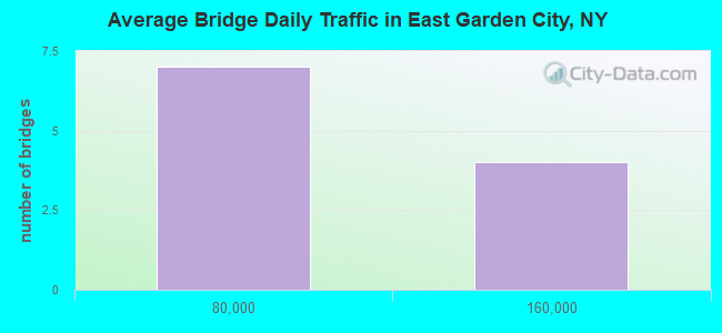
- 672,388Total average daily traffic
- 4,229Total average daily truck traffic
- National Bridge Inventory (NBI) Registered Bridges for East Garden City
- No street view available for this location
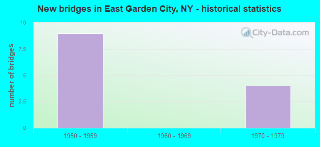
- New bridges - historical statistics
- 91950-1959
- 41970-1979
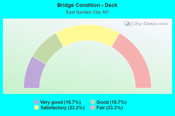
- Bridge Condition - Deck
- 16.7%Very good
- 16.7%Good
- 33.3%Satisfactory
- 33.3%Fair
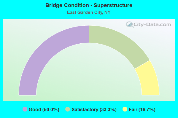
- Bridge Condition - Superstructure
- 50.0%Good
- 33.3%Satisfactory
- 16.7%Fair
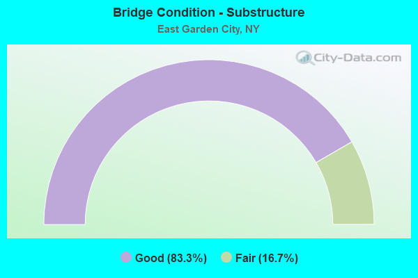
- Bridge Condition - Substructure
- 83.3%Good
- 16.7%Fair
Find on map >> Show street view
Structure Number: 101808, Location: 700 FT W JCT SH 24 & MSP (Lat: 40.721467, Lng: -73.582814), Route carried "on" structure: State highway 24, Year Built: 1956, Status: Open, Structure Length: 0.85m (2.79ft), Average Daily Traffic: 28,506 (year 2020), Truck Traffic: 5%, Average Future Daily Traffic: 32,890 (year 2040), Design Load: HS 20+Mod, Features Intersected: CULVERT
Minimum Vertical Clearance: 30+ m (98+ ft), Kilometerpoint: 12.775, Lanes on structure: 8, Base Highway Network: Yes, Owner: State Highway Agency, Approaching Roadway Width: 33.5m (109.9ft), Skew: 20 degrees, Material/Design: Concrete, Design/Construction: Culvert, Number Of Spans In Main Unit: 3, Length of Maximum Span: 2.7m (8.9ft), Curb or Sidewalk Widths: Left: 3.4m (11.2ft), Right: 1.2m (3.9ft), Curb-To-Curb Width: 33.4m (109.6ft), Out-to-Out Width: 68.6m (225.1ft)
Condition: Channel: Good, Culverts: Good, Structural Evaluation: Better than present minimum criteria, Deck Geometry: Equal to present minimum criteria, Waterway Adequacy: Meets minimum limits, Approach Roadway Alignment: Equal to present desirable criteria, Length Of Structure Improvement: 0.85m (2.79ft), Designated Inspection Frequency: Every 24 months, Inspection Date: October 2021, Bridge Improvement Cost: $2,497,000, Roadway Improvement Cost: $1,462,000, Total Project Cost: $3,959,000 ( Estimate for 2021)
Find on map >> Show street view
Structure Number: 1018099, Location: 2.3 MI W JCT RTS 24+WSP (Lat: 40.722194, Lng: -73.580522), Route carried "on" structure: State highway 24, Year Built: 1956, Status: Open, Structure Length: 3.75m (12.30ft), Average Daily Traffic: 28,506 (year 2020), Truck Traffic: 5%, Average Future Daily Traffic: 32,890 (year 2040), Design Load: H 20, Features Intersected: 908E908E03011091 NB, RTE
Minimum Vertical Clearance: 30+ m (98+ ft), Kilometerpoint: 12.920, Lanes on structure: 6, Lanes under structure: 6, Base Highway Network: Yes, Owner: State Highway Agency, Approaching Roadway Width: 21.3m (69.9ft), Skew: 31 degrees, Material/Design: Concrete continuous, Design/Construction: Frame, Number Of Spans In Main Unit: 2, Length of Maximum Span: 18.2m (59.7ft), Curb or Sidewalk Widths: Left: 3.0m (9.8ft), Right: 3.0m (9.8ft), Curb-To-Curb Width: 21.3m (69.9ft), Out-to-Out Width: 29.6m (97.1ft)
Condition: Deck: Satisfactory, Superstructure: Satisfactory, Substructure: Good, Operating Rating: 89.8 metric tons, Method Used To Determine Operating Rating: Load Factor (LF), Inventory Rating: 58.1 metric tons, Method Used To Determine Inventory Rating: Load Factor (LF), Structural Evaluation: Equal to present minimum criteria, Deck Geometry: High priority of replacement, Underclear: High priority of corrective action, Approach Roadway Alignment: Equal to present desirable criteria, Length Of Structure Improvement: 3.74m (12.27ft), Designated Inspection Frequency: Every 24 months, Inspection Date: July 2021, Bridge Improvement Cost: $5,637,000, Roadway Improvement Cost: $3,301,000, Total Project Cost: $8,938,000 ( Estimate for 2021), Wearing Surface/Protective System: Wearing Surface: Integral Concrete
Find on map >> Show street view
Structure Number: 105664, Location: AT EAST MEADOW-N OF SSP (Lat: 40.735450, Lng: -73.587239), Route carried "on" structure: Ramp Other road , Year Built: 1971, Status: Open, Structure Length: 4.39m (14.40ft), Truck Traffic: 2%, Design Load: HS 20+Mod, Features Intersected: MSP Service Road, Facility Carried by Structure: STEWART AV-MSP SB
Minimum Vertical Clearance: 30+ m (98+ ft), Kilometerpoint: 0.257, Lanes on structure: 2, Lanes under structure: 2, Owner: State Highway Agency, Approaching Roadway Width: 8.2m (26.9ft), Skew: 6 degrees, Material/Design: Steel, Design/Construction: Stringer/Multi-beam, Number Of Spans In Main Unit: 1, Length of Maximum Span: 43.0m (141.1ft), Curb-To-Curb Width: 8.3m (27.2ft), Out-to-Out Width: 9.4m (30.8ft)
Condition: Deck: Very good, Superstructure: Good, Substructure: Good, Inventory Rating: 32.7 metric tons, Method Used To Determine Inventory Rating: Field evaluation and documented engineering judgment, Structural Evaluation: Better than present minimum criteria, Deck Geometry: High priority of corrective action, Underclear: High priority of corrective action, Approach Roadway Alignment: Better than present minimum criteria, Length Of Structure Improvement: 4.38m (14.37ft), Designated Inspection Frequency: Every 24 months, Inspection Date: October 2021, Bridge Improvement Cost: $3,326,000, Roadway Improvement Cost: $1,948,000, Total Project Cost: $5,273,000 ( Estimate for 2021), Deck Structure Type: Concrete Cast-file-Place, Wearing Surface/Protective System: Wearing Surface: Integral Concrete
Find on map >> Show street view
Structure Number: 105667, Location: 2.3 N OF HEMPSTEAD (Lat: 40.727953, Lng: -73.581656), Route carried "on" structure: Ramp Other road , Year Built: 1971, Status: Open, Structure Length: 3.23m (10.60ft), Truck Traffic: 2%, Design Load: HS 20+Mod, Features Intersected: MSP Service Road, Facility Carried by Structure: LINDBERGH BLV-MSP
Minimum Vertical Clearance: 30+ m (98+ ft), Kilometerpoint: 0.193, Lanes on structure: 2, Lanes under structure: 2, Owner: State Highway Agency, Approaching Roadway Width: 8.5m (27.9ft), Skew: 4 degrees, Material/Design: Steel, Design/Construction: Stringer/Multi-beam, Number Of Spans In Main Unit: 1, Length of Maximum Span: 30.8m (101.0ft), Curb-To-Curb Width: 8.5m (27.9ft), Out-to-Out Width: 9.7m (31.8ft)
Condition: Deck: Good, Superstructure: Good, Substructure: Good, Operating Rating: 73.5 metric tons, Method Used To Determine Operating Rating: Load Factor (LF), Inventory Rating: 43.5 metric tons, Method Used To Determine Inventory Rating: Load Factor (LF), Structural Evaluation: Better than present minimum criteria, Deck Geometry: High priority of corrective action, Underclear: High priority of corrective action, Approach Roadway Alignment: Equal to present desirable criteria, Length Of Structure Improvement: 3.23m (10.60ft), Designated Inspection Frequency: Every 24 months, Inspection Date: October 2021, Bridge Improvement Cost: $2,109,000, Roadway Improvement Cost: $1,235,000, Total Project Cost: $3,345,000 ( Estimate for 2021), Deck Structure Type: Concrete Cast-file-Place, Wearing Surface/Protective System: Wearing Surface: Integral Concrete
Find on map >> Show street view
Structure Number: 1059269, Location: AT EAST MEADOW-N OF SSP (Lat: 40.736617, Lng: -73.588906), Route carried "on" structure: County highway , Year Built: 1955, Year Reconstructed: 2010, Status: Open, Structure Length: 5.36m (17.59ft), Average Daily Traffic: 18,839 (year 2019), Truck Traffic: 3%, Average Future Daily Traffic: 22,885 (year 2040), Design Load: HS 20, Features Intersected: 908E908E03011102, RTE 90, Facility Carried by Structure: STEWART AVENUE
Minimum Vertical Clearance: 30+ m (98+ ft), Kilometerpoint: 2.703, Lanes on structure: 6, Lanes under structure: 6, Owner: State Highway Agency, Approaching Roadway Width: 23.5m (77.1ft), Skew: 25 degrees, Material/Design: Steel, Design/Construction: Stringer/Multi-beam, Number Of Spans In Main Unit: 2, Length of Maximum Span: 26.8m (87.9ft), Curb or Sidewalk Widths: Left: 3.6m (11.8ft), Right: 3.4m (11.2ft), Curb-To-Curb Width: 23.5m (77.1ft), Out-to-Out Width: 31.4m (103.0ft)
Condition: Deck: Fair, Superstructure: Satisfactory, Substructure: Good, Operating Rating: 62.6 metric tons, Method Used To Determine Operating Rating: Load Factor (LF), Inventory Rating: 37.2 metric tons, Method Used To Determine Inventory Rating: Load Factor (LF), Structural Evaluation: Equal to present minimum criteria, Deck Geometry: Somewhat better than minimum adequacy, Underclear: High priority of corrective action, Approach Roadway Alignment: Equal to present desirable criteria, Length Of Structure Improvement: 5.36m (17.59ft), Designated Inspection Frequency: Every 24 months, Inspection Date: May 2020, Bridge Improvement Cost: $9,789,000, Roadway Improvement Cost: $5,733,000, Total Project Cost: $15,522,000 ( Estimate for 2021), Deck Structure Type: Concrete Cast-file-Place, Wearing Surface/Protective System: Wearing Surface: Monolithic Concrete
Find on map >> Show street view
Structure Number: 105927, Location: SW OF E MEADOW- N OF SSP (Lat: 40.737350, Lng: -73.593139), Route carried "on" structure: Other road , Year Built: 1955, Status: Open, Structure Length: 3.20m (10.50ft), Average Daily Traffic: 20,926 (year 2019), Truck Traffic: 2%, Average Future Daily Traffic: 25,891 (year 2040), Design Load: HS 20, Features Intersected: 908E908E03011105, N/B, R, Facility Carried by Structure: AVENUE C
Minimum Vertical Clearance: 30+ m (98+ ft), Kilometerpoint: 0.129, Lanes on structure: 5, Lanes under structure: 6, Owner: State Highway Agency, Approaching Roadway Width: 16.8m (55.1ft), Skew: 2 degrees, Material/Design: Concrete continuous, Design/Construction: Frame, Number Of Spans In Main Unit: 2, Length of Maximum Span: 14.6m (47.9ft), Curb or Sidewalk Widths: Left: 3.0m (9.8ft), Right: 3.0m (9.8ft), Curb-To-Curb Width: 16.8m (55.1ft), Out-to-Out Width: 23.8m (78.1ft)
Condition: Deck: Fair, Superstructure: Fair, Substructure: Fair, Operating Rating: 83.0 metric tons, Method Used To Determine Operating Rating: Field evaluation and documented engineering judgment, Inventory Rating: 32.7 metric tons, Method Used To Determine Inventory Rating: Field evaluation and documented engineering judgment, Structural Evaluation: Somewhat better than minimum adequacy, Deck Geometry: High priority of replacement, Underclear: High priority of corrective action, Approach Roadway Alignment: Equal to present desirable criteria, Length Of Structure Improvement: 3.20m (10.50ft), Designated Inspection Frequency: Every 24 months, Inspection Date: March 2021, Bridge Improvement Cost: $4,050,000, Roadway Improvement Cost: $2,372,000, Total Project Cost: $6,422,000 ( Estimate for 2021), Wearing Surface/Protective System: Wearing Surface: Bituminous, Membrane: Preformed Fabric
Find on map >> Show street view
Structure Number: 1059289, Location: AT EAST MEADOW-N OF SSP (Lat: 40.737561, Lng: -73.607664), Route carried "on" structure: Other road , Year Built: 1956, Status: Open, Structure Length: 3.60m (11.81ft), Average Daily Traffic: 29,719 (year 2018), Truck Traffic: 1%, Average Future Daily Traffic: 41,607 (year 2038), Design Load: HS 20, Features Intersected: 908E908E03011113, N/B, R, Facility Carried by Structure: ZECKENDORF BLVD
Minimum Vertical Clearance: 30+ m (98+ ft), Kilometerpoint: 0.193, Lanes on structure: 6, Lanes under structure: 8, Owner: State Highway Agency, Approaching Roadway Width: 18.3m (60.0ft), Skew: 20 degrees, Material/Design: Concrete continuous, Design/Construction: Frame, Number Of Spans In Main Unit: 2, Length of Maximum Span: 16.7m (54.8ft), Curb or Sidewalk Widths: Left: 2.4m (7.9ft), Right: 2.4m (7.9ft), Curb-To-Curb Width: 18.3m (60.0ft), Out-to-Out Width: 25.3m (83.0ft)
Condition: Deck: Satisfactory, Superstructure: Good, Substructure: Good, Operating Rating: 84.6 metric tons, Method Used To Determine Operating Rating: Field evaluation and documented engineering judgment, Inventory Rating: 32.7 metric tons, Method Used To Determine Inventory Rating: Field evaluation and documented engineering judgment, Structural Evaluation: Better than present minimum criteria, Deck Geometry: High priority of replacement, Underclear: High priority of corrective action, Approach Roadway Alignment: Equal to present desirable criteria, Length Of Structure Improvement: 3.59m (11.78ft), Designated Inspection Frequency: Every 24 months, Inspection Date: March 2021, Bridge Improvement Cost: $4,500,000, Roadway Improvement Cost: $2,635,000, Total Project Cost: $7,136,000 ( Estimate for 2021), Wearing Surface/Protective System: Wearing Surface: Bituminous, Membrane: Other
Find on map >> Show street view
Structure Number: 1018099, Location: 2.3 MI W JCT RTS 24+WSP (Lat: 40.722194, Lng: -73.580522), Route carried "under" structure: State highway 908E, Year Built: 1956, Structure Length: 0. m, Average Daily Traffic: 138,338 (year 2002), Features Intersected: 908E908E03011091 NB, RTE, Facility Carried by Structure: RTE 24
Minimum Vertical Clearance: 3.86m (12.66ft), Kilometerpoint: 14.465, Lanes on structure: 6, Lanes under structure: 3, Material/Design: Concrete continuous, Design/Construction: Frame, Length of Maximum Span: 18.2m (59.7ft)
Find on map >> Show street view
Structure Number: 105664, Location: AT EAST MEADOW-N OF SSP (Lat: 40.735450, Lng: -73.587239), Route carried "under" structure: Ramp Other road , Year Built: 1971, Structure Length: 0. m, Average Daily Traffic: 8,500 (year 2021), Features Intersected: MSP Service Road, Facility Carried by Structure: STEWART AV-MSP SB
Minimum Vertical Clearance: 3.96m (12.99ft), Kilometerpoint: 0.000, Lanes on structure: 2, Lanes under structure: 2, Material/Design: Steel, Design/Construction: Stringer/Multi-beam, Length of Maximum Span: 43.0m (141.1ft)
Find on map >> Show street view
Structure Number: 105667, Location: 2.3 N OF HEMPSTEAD (Lat: 40.727953, Lng: -73.581656), Route carried "under" structure: ServiceOther road , Year Built: 1971, Structure Length: 0. m, Average Daily Traffic: 4,952 (year 2020), Truck Traffic: 2%, Features Intersected: MSP Service Road, Facility Carried by Structure: LINDBERGH BLV-MSP
Minimum Vertical Clearance: 4.06m (13.32ft), Kilometerpoint: 0.788, Lanes on structure: 2, Lanes under structure: 2, Material/Design: Steel, Design/Construction: Stringer/Multi-beam, Length of Maximum Span: 30.8m (101.0ft)
Find on map >> Show street view
Structure Number: 1059269, Location: AT EAST MEADOW-N OF SSP (Lat: 40.736617, Lng: -73.588906), Route carried "under" structure: State highway 908E, Year Built: 1955, Structure Length: 0. m, Average Daily Traffic: 133,575 (year 2002), Features Intersected: 908E908E03011102, RTE 90, Facility Carried by Structure: STEWART AVENUE
Minimum Vertical Clearance: 4.14m (13.58ft), Kilometerpoint: 16.364, Lanes on structure: 6, Lanes under structure: 3, Material/Design: Steel, Design/Construction: Stringer/Multi-beam, Length of Maximum Span: 26.8m (87.9ft)
Find on map >> Show street view
Structure Number: 105927, Location: SW OF E MEADOW- N OF SSP (Lat: 40.737350, Lng: -73.593139), Route carried "under" structure: State highway 908E, Year Built: 1955, Structure Length: 0. m, Average Daily Traffic: 133,575 (year 2002), Features Intersected: 908E908E03011105, N/B, R, Facility Carried by Structure: AVENUE C
Minimum Vertical Clearance: 4.42m (14.50ft), Kilometerpoint: 16.734, Lanes on structure: 5, Lanes under structure: 3, Material/Design: Concrete continuous, Design/Construction: Frame, Length of Maximum Span: 14.6m (47.9ft)
Find on map >> Show street view
Structure Number: 1059289, Location: AT EAST MEADOW-N OF SSP (Lat: 40.737561, Lng: -73.607664), Route carried "under" structure: State highway 908E, Year Built: 1956, Structure Length: 0. m, Average Daily Traffic: 126,952 (year 2002), Features Intersected: 908E908E03011113, N/B, R, Facility Carried by Structure: ZECKENDORF BLVD
Minimum Vertical Clearance: 3.96m (12.99ft), Kilometerpoint: 17.989, Lanes on structure: 6, Lanes under structure: 4, Material/Design: Concrete continuous, Design/Construction: Frame, Length of Maximum Span: 16.7m (54.8ft)