Bridge Statistics for East Aurora, New York (NY)
Condition, Traffic, Stress, Structural Evaluation, Project Costs
- National Bridge Inventory (NBI) Statistics
- 37Number of bridges
- 636ft / 194mTotal length
- $142,845,000Total costs
- 149,901Total average daily traffic
- 6,258Total average daily truck traffic
- National Bridge Inventory (NBI) Registered Bridges for East Aurora
- No street view available for this location
- New bridges - historical statistics
- 71930-1939
- 21950-1959
- 31960-1969
- 181970-1979
- 31980-1989
- 21990-1999
- 22000-2009
- Reconstructed bridges - Historical Statistics
- 21980-1989
- 01990-1999
- 12000-2009
- 32010-2019
- Bridge Condition - Deck
- 10.0%Very good
- 70.0%Good
- 15.0%Satisfactory
- 5.0%Fair
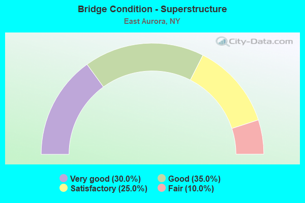
- Bridge Condition - Superstructure
- 30.0%Very good
- 35.0%Good
- 25.0%Satisfactory
- 10.0%Fair
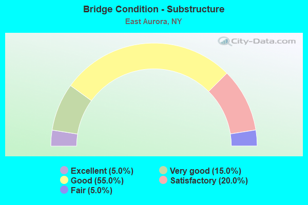
- Bridge Condition - Substructure
- 5.0%Excellent
- 15.0%Very good
- 55.0%Good
- 20.0%Satisfactory
- 5.0%Fair
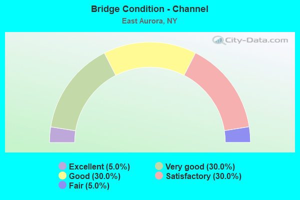
- Bridge Condition - Channel
- 5.0%Excellent
- 30.0%Very good
- 30.0%Good
- 30.0%Satisfactory
- 5.0%Fair
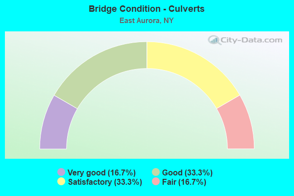
- Bridge Condition - Culverts
- 16.7%Very good
- 33.3%Good
- 33.3%Satisfactory
- 16.7%Fair
Find on map >> Show street view
Structure Number: 101609, Location: 2.7 MI E JCT RT5 20A+ I87 (Lat: 42.761706, Lng: -78.644978), Route carried "on" structure: US 20A, Year Built: 2005, Status: Open, Structure Length: 6.55m (21.49ft), Average Daily Traffic: 5,611 (year 2018), Truck Traffic: 3%, Average Future Daily Traffic: 5,637 (year 2040), Design Load: HS 25 or greater, Features Intersected: CAZENOVIA CREEK
Minimum Vertical Clearance: 30+ m (98+ ft), Kilometerpoint: 13.886, Lanes on structure: 2, Base Highway Network: Yes, Owner: State Highway Agency, Approaching Roadway Width: 11.9m (39.0ft), Material/Design: Steel, Design/Construction: Stringer/Multi-beam, Number Of Spans In Main Unit: 1, Length of Maximum Span: 65.0m (213.3ft), Curb-To-Curb Width: 12.0m (39.4ft), Out-to-Out Width: 13.0m (42.7ft)
Condition: Deck: Very good, Superstructure: Very good, Substructure: Excellent, Channel: Excellent, Operating Rating: 51.8 metric tons, Method Used To Determine Operating Rating: Load and Resistance Factor Rating (LRFR) rating reported by rating factor(RF) method using HL-93 loadings, Inventory Rating: 38.9 metric tons, Method Used To Determine Inventory Rating: Load and Resistance Factor Rating (LRFR) rating reported by rating factor(RF) method using HL-93 loadings, Structural Evaluation: Equal to present desirable criteria, Deck Geometry: Somewhat better than minimum adequacy, Waterway Adequacy: Equal to present desirable criteria, Approach Roadway Alignment: Equal to present desirable criteria, Length Of Structure Improvement: 6.55m (21.49ft), Designated Inspection Frequency: Every 24 months, Inspection Date: March 2021, Bridge Improvement Cost: $3,509,000, Roadway Improvement Cost: $2,055,000, Total Project Cost: $5,564,000 ( Estimate for 2021), Deck Structure Type: Concrete Cast-file-Place, Wearing Surface/Protective System: Wearing Surface: Integral Concrete, Deck Protection: Epoxy Coated Reinforcing
Find on map >> Show street view
Structure Number: 1047541, Location: 3.7 MI S JCT RTS 400 +20A (Lat: 42.717250, Lng: -78.586403), Route carried "on" structure: State highway 400, Year Built: 1971, Status: Open, Structure Length: 2.77m (9.09ft), Average Daily Traffic: 4,366 (year 2018), Truck Traffic: 12%, Average Future Daily Traffic: 4,407 (year 2040), Design Load: HS 20, Features Intersected: CAZENOVIA CREEK
Minimum Vertical Clearance: 30+ m (98+ ft), Kilometerpoint: 23.009, Lanes on structure: 2, Base Highway Network: Yes, Owner: State Highway Agency, Approaching Roadway Width: 13.7m (44.9ft), Material/Design: Steel, Design/Construction: Stringer/Multi-beam, Number Of Spans In Main Unit: 1, Length of Maximum Span: 26.8m (87.9ft), Curb-To-Curb Width: 11.9m (39.0ft), Out-to-Out Width: 12.8m (42.0ft)
Condition: Deck: Good, Superstructure: Very good, Substructure: Good, Channel: Very good, Operating Rating: 84.4 metric tons, Method Used To Determine Operating Rating: Load Factor (LF), Inventory Rating: 49.9 metric tons, Method Used To Determine Inventory Rating: Load Factor (LF), Structural Evaluation: Better than present minimum criteria, Deck Geometry: Better than present minimum criteria, Waterway Adequacy: Somewhat better than minimum adequacy, Approach Roadway Alignment: Equal to present minimum criteria, Length Of Structure Improvement: 2.77m (9.09ft), Designated Inspection Frequency: Every 24 months, Inspection Date: March 2021, Bridge Improvement Cost: $1,645,000, Roadway Improvement Cost: $963,000, Total Project Cost: $2,608,000 ( Estimate for 2021), Deck Structure Type: Concrete Cast-file-Place, Wearing Surface/Protective System: Wearing Surface: Integral Concrete
Find on map >> Show street view
Structure Number: 1047542, Location: 3.7 MI S JCT RTS 400 +20A (Lat: 42.717394, Lng: -78.586169), Route carried "on" structure: State highway 400, Year Built: 1971, Status: Open, Structure Length: 2.80m (9.19ft), Average Daily Traffic: 4,366 (year 2018), Truck Traffic: 12%, Average Future Daily Traffic: 4,407 (year 2040), Design Load: HS 20, Features Intersected: E BR CAZENOVIA CK
Minimum Vertical Clearance: 30+ m (98+ ft), Kilometerpoint: 23.009, Lanes on structure: 2, Base Highway Network: Yes, Owner: State Highway Agency, Approaching Roadway Width: 13.7m (44.9ft), Skew: 2 degrees, Material/Design: Steel, Design/Construction: Stringer/Multi-beam, Number Of Spans In Main Unit: 1, Length of Maximum Span: 26.8m (87.9ft), Curb-To-Curb Width: 13.9m (45.6ft), Out-to-Out Width: 14.8m (48.6ft)
Condition: Deck: Good, Superstructure: Very good, Substructure: Very good, Channel: Very good, Operating Rating: 86.2 metric tons, Method Used To Determine Operating Rating: Load Factor (LF), Inventory Rating: 51.7 metric tons, Method Used To Determine Inventory Rating: Load Factor (LF), Structural Evaluation: Equal to present desirable criteria, Deck Geometry: Superior to present desirable criteria, Waterway Adequacy: Somewhat better than minimum adequacy, Approach Roadway Alignment: Somewhat better than minimum adequacy, Length Of Structure Improvement: 2.80m (9.19ft), Designated Inspection Frequency: Every 24 months, Inspection Date: March 2021, Bridge Improvement Cost: $2,012,000, Roadway Improvement Cost: $1,178,000, Total Project Cost: $3,191,000 ( Estimate for 2021), Deck Structure Type: Concrete Cast-file-Place, Wearing Surface/Protective System: Wearing Surface: Integral Concrete
Find on map >> Show street view
Structure Number: 104755, Location: 2.5 MI S JCT SH400 &US20A (Lat: 42.732094, Lng: -78.597978), Route carried "on" structure: County highway , Year Built: 1971, Status: Open, Structure Length: 7.71m (25.30ft), Average Daily Traffic: 980 (year 2018), Truck Traffic: 6%, Average Future Daily Traffic: 1,372 (year 2038), Design Load: HS 20+Mod, Features Intersected: 400 400 53011015 NB, RTE, Facility Carried by Structure: BLAKELEY CORNERS R
Minimum Vertical Clearance: 30+ m (98+ ft), Kilometerpoint: 4.553, Lanes on structure: 2, Lanes under structure: 4, Owner: State Highway Agency, Approaching Roadway Width: 9.8m (32.2ft), Skew: 3 degrees, Material/Design: Steel, Design/Construction: Stringer/Multi-beam, Number Of Spans In Main Unit: 2, Length of Maximum Span: 38.4m (126.0ft), Curb-To-Curb Width: 10.7m (35.1ft), Out-to-Out Width: 11.6m (38.1ft)
Condition: Deck: Good, Superstructure: Fair, Substructure: Fair, Operating Rating: 85.3 metric tons, Method Used To Determine Operating Rating: Load Factor (LF), Inventory Rating: 50.8 metric tons, Method Used To Determine Inventory Rating: Load Factor (LF), Structural Evaluation: Somewhat better than minimum adequacy, Deck Geometry: Equal to present minimum criteria, Underclear: Meets minimum limits, Approach Roadway Alignment: Meets minimum limits, Length Of Structure Improvement: 7.71m (25.30ft), Designated Inspection Frequency: Every 24 months, Inspection Date: June 2021, Bridge Improvement Cost: $3,605,000, Roadway Improvement Cost: $2,111,000, Total Project Cost: $5,716,000 ( Estimate for 2021), Deck Structure Type: Concrete Cast-file-Place, Wearing Surface/Protective System: Wearing Surface: Integral Concrete
Find on map >> Show street view
Structure Number: 1047561, Location: 2.2 MI S JCT RTS 400 +20A (Lat: 42.737439, Lng: -78.600556), Route carried "on" structure: State highway 400, Year Built: 1971, Status: Open, Structure Length: 6.25m (20.51ft), Average Daily Traffic: 3,310 (year 2017), Truck Traffic: 12%, Average Future Daily Traffic: 3,495 (year 2040), Design Load: HS 20, Features Intersected: CAZENOVIA CREEK
Minimum Vertical Clearance: 30+ m (98+ ft), Kilometerpoint: 3.121, Lanes on structure: 3, Base Highway Network: Yes, Owner: State Highway Agency, Approaching Roadway Width: 15.2m (49.9ft), Skew: 1 degrees, Material/Design: Steel continuous, Design/Construction: Stringer/Multi-beam, Number Of Spans In Main Unit: 3, Length of Maximum Span: 26.2m (86.0ft), Curb-To-Curb Width: 13.9m (45.6ft), Out-to-Out Width: 14.8m (48.6ft)
Condition: Deck: Good, Superstructure: Good, Substructure: Satisfactory, Channel: Good, Operating Rating: 68.0 metric tons, Method Used To Determine Operating Rating: Load Factor (LF), Inventory Rating: 36.3 metric tons, Method Used To Determine Inventory Rating: Load Factor (LF), Structural Evaluation: Equal to present minimum criteria, Deck Geometry: Somewhat better than minimum adequacy, Waterway Adequacy: Somewhat better than minimum adequacy, Approach Roadway Alignment: Equal to present minimum criteria, Length Of Structure Improvement: 6.24m (20.47ft), Designated Inspection Frequency: Every 24 months, Inspection Date: May 2021, Bridge Improvement Cost: $3,384,000, Roadway Improvement Cost: $1,982,000, Total Project Cost: $5,365,000 ( Estimate for 2021), Deck Structure Type: Concrete Cast-file-Place, Wearing Surface/Protective System: Wearing Surface: Integral Concrete
Find on map >> Show street view
Structure Number: 1047562, Location: 2.2 MI S JCT RTS 400 +20A (Lat: 42.737517, Lng: -78.600194), Route carried "on" structure: State highway 400, Year Built: 1971, Status: Open, Structure Length: 5.94m (19.49ft), Average Daily Traffic: 3,310 (year 2017), Truck Traffic: 12%, Average Future Daily Traffic: 3,495 (year 2040), Design Load: HS 20, Features Intersected: CAZENOVIA CREEK
Minimum Vertical Clearance: 30+ m (98+ ft), Kilometerpoint: 3.121, Lanes on structure: 2, Base Highway Network: Yes, Owner: State Highway Agency, Approaching Roadway Width: 12.8m (42.0ft), Skew: 1 degrees, Material/Design: Steel continuous, Design/Construction: Stringer/Multi-beam, Number Of Spans In Main Unit: 3, Length of Maximum Span: 26.2m (86.0ft), Curb-To-Curb Width: 12.0m (39.4ft), Out-to-Out Width: 13.0m (42.7ft)
Condition: Deck: Good, Superstructure: Good, Substructure: Good, Channel: Good, Operating Rating: 58.1 metric tons, Method Used To Determine Operating Rating: Load Factor (LF), Inventory Rating: 34.5 metric tons, Method Used To Determine Inventory Rating: Load Factor (LF), Structural Evaluation: Better than present minimum criteria, Deck Geometry: Better than present minimum criteria, Waterway Adequacy: Somewhat better than minimum adequacy, Approach Roadway Alignment: Equal to present minimum criteria, Length Of Structure Improvement: 5.94m (19.49ft), Designated Inspection Frequency: Every 24 months, Inspection Date: May 2021, Bridge Improvement Cost: $2,890,000, Roadway Improvement Cost: $1,692,000, Total Project Cost: $4,582,000 ( Estimate for 2021), Deck Structure Type: Concrete Cast-file-Place, Wearing Surface/Protective System: Wearing Surface: Integral Concrete
Find on map >> Show street view
Structure Number: 104757, Location: 1 MI S JCT SH 400 & US20A (Lat: 42.753344, Lng: -78.595322), Route carried "on" structure: County highway , Year Built: 1971, Status: Open, Structure Length: 7.16m (23.49ft), Average Daily Traffic: 646 (year 2017), Truck Traffic: 4%, Average Future Daily Traffic: 904 (year 2037), Design Load: HS 20+Mod, Features Intersected: 400 400 53011030 NB, RTE, Facility Carried by Structure: COUNTY ROAD 381
Minimum Vertical Clearance: 30+ m (98+ ft), Kilometerpoint: 1.432, Lanes on structure: 2, Lanes under structure: 4, Owner: State Highway Agency, Approaching Roadway Width: 11.3m (37.1ft), Material/Design: Steel continuous, Design/Construction: Stringer/Multi-beam, Number Of Spans In Main Unit: 2, Length of Maximum Span: 35.0m (114.8ft), Curb-To-Curb Width: 9.4m (30.8ft), Out-to-Out Width: 10.4m (34.1ft)
Condition: Deck: Good, Superstructure: Very good, Substructure: Good, Operating Rating: 33.7 metric tons, Method Used To Determine Operating Rating: Load and Resistance Factor Rating (LRFR) rating reported by rating factor(RF) method using HL-93 loadings, Inventory Rating: 25.9 metric tons, Method Used To Determine Inventory Rating: Load and Resistance Factor Rating (LRFR) rating reported by rating factor(RF) method using HL-93 loadings, Structural Evaluation: Equal to present minimum criteria, Deck Geometry: Equal to present minimum criteria, Underclear: Equal to present minimum criteria, Approach Roadway Alignment: Meets minimum limits, Length Of Structure Improvement: 7.16m (23.49ft), Designated Inspection Frequency: Every 24 months, Inspection Date: June 2021, Bridge Improvement Cost: $3,160,000, Roadway Improvement Cost: $1,851,000, Total Project Cost: $5,011,000 ( Estimate for 2021), Deck Structure Type: Concrete Cast-file-Place, Wearing Surface/Protective System: Wearing Surface: Bituminous
Find on map >> Show street view
Structure Number: 1054581, Location: 1.7 MI S JCT RTS 400 +20A (Lat: 42.742183, Lng: -78.600669), Route carried "on" structure: State highway 400, Year Built: 1971, Year Reconstructed: 2019, Status: Open, Structure Length: 50.47m (165.58ft), Average Daily Traffic: 3,310 (year 2017), Truck Traffic: 12%, Average Future Daily Traffic: 3,495 (year 2040), Design Load: HS 20, Features Intersected: RTE 16, NORFOLK SO/B&P R
Minimum Vertical Clearance: 30+ m (98+ ft), Kilometerpoint: 3.524, Lanes on structure: 2, Lanes under structure: 2, Base Highway Network: Yes, Owner: State Highway Agency, Approaching Roadway Width: 11.9m (39.0ft), Skew: 4 degrees, Material/Design: Steel, Design/Construction: Stringer/Multi-beam, Number Of Spans In Main Unit: 1, Number Of Approach Spans: 16, Length of Maximum Span: 40.5m (132.9ft), Curb-To-Curb Width: 11.9m (39.0ft), Out-to-Out Width: 13.2m (43.3ft)
Condition: Deck: Good, Superstructure: Satisfactory, Substructure: Good, Operating Rating: 55.1 metric tons, Method Used To Determine Operating Rating: Load and Resistance Factor Rating (LRFR) rating reported by rating factor(RF) method using HL-93 loadings, Inventory Rating: 10.4 metric tons, Method Used To Determine Inventory Rating: Load and Resistance Factor Rating (LRFR) rating reported by rating factor(RF) method using HL-93 loadings, Structural Evaluation: High priority of corrective action, Deck Geometry: Better than present minimum criteria, Underclear: Somewhat better than minimum adequacy, Approach Roadway Alignment: Somewhat better than minimum adequacy, Length Of Structure Improvement: 50.47m (165.58ft), Designated Inspection Frequency: Every 24 months, Inspection Date: November 2020, Bridge Improvement Cost: $22,282,000, Roadway Improvement Cost: $13,048,000, Total Project Cost: $35,330,000 ( Estimate for 2021), Deck Structure Type: Concrete Cast-file-Place, Wearing Surface/Protective System: Wearing Surface: Monolithic Concrete
Find on map >> Show street view
Structure Number: 1054582, Location: 1.7 MI S JCT RTS 400 +20A (Lat: 42.741939, Lng: -78.600450), Route carried "on" structure: State highway 400, Year Built: 1971, Year Reconstructed: 2019, Status: Open, Structure Length: 50.41m (165.39ft), Average Daily Traffic: 3,310 (year 2017), Truck Traffic: 12%, Average Future Daily Traffic: 3,495 (year 2040), Design Load: HS 20, Features Intersected: RTE 16, NORFOLK SO/B&P R
Minimum Vertical Clearance: 30+ m (98+ ft), Kilometerpoint: 3.524, Lanes on structure: 2, Lanes under structure: 2, Base Highway Network: Yes, Owner: State Highway Agency, Approaching Roadway Width: 11.9m (39.0ft), Skew: 4 degrees, Material/Design: Steel, Design/Construction: Stringer/Multi-beam, Number Of Spans In Main Unit: 1, Number Of Approach Spans: 16, Length of Maximum Span: 41.8m (137.1ft), Curb-To-Curb Width: 11.9m (39.0ft), Out-to-Out Width: 13.2m (43.3ft)
Condition: Deck: Good, Superstructure: Satisfactory, Substructure: Good, Operating Rating: 50.9 metric tons, Method Used To Determine Operating Rating: Load and Resistance Factor Rating (LRFR) rating reported by rating factor(RF) method using HL-93 loadings, Inventory Rating: 12.6 metric tons, Method Used To Determine Inventory Rating: Load and Resistance Factor Rating (LRFR) rating reported by rating factor(RF) method using HL-93 loadings, Structural Evaluation: Meets minimum limits, Deck Geometry: Better than present minimum criteria, Underclear: Somewhat better than minimum adequacy, Approach Roadway Alignment: Somewhat better than minimum adequacy, Length Of Structure Improvement: 50.41m (165.39ft), Designated Inspection Frequency: Every 24 months, Inspection Date: November 2020, Bridge Improvement Cost: $22,256,000, Roadway Improvement Cost: $13,033,000, Total Project Cost: $35,289,000 ( Estimate for 2021), Deck Structure Type: Concrete Cast-file-Place, Wearing Surface/Protective System: Wearing Surface: Monolithic Concrete
Find on map >> Show street view
Structure Number: 1054591, Location: JCT RTS 400 + 20A (Lat: 42.767533, Lng: -78.593428), Route carried "on" structure: State highway 400, Year Built: 1971, Status: Open, Structure Length: 4.08m (13.39ft), Average Daily Traffic: 5,594 (year 2018), Truck Traffic: 12%, Average Future Daily Traffic: 6,482 (year 2040), Design Load: HS 20+Mod, Features Intersected: RTE 20A
Minimum Vertical Clearance: 30+ m (98+ ft), Kilometerpoint: 6.500, Lanes on structure: 2, Lanes under structure: 3, Base Highway Network: Yes, Owner: State Highway Agency, Approaching Roadway Width: 13.7m (44.9ft), Skew: 1 degrees, Material/Design: Steel, Design/Construction: Stringer/Multi-beam, Number Of Spans In Main Unit: 1, Length of Maximum Span: 39.3m (128.9ft), Curb-To-Curb Width: 11.9m (39.0ft), Out-to-Out Width: 12.8m (42.0ft)
Condition: Deck: Good, Superstructure: Good, Substructure: Satisfactory, Operating Rating: 94.3 metric tons, Method Used To Determine Operating Rating: Load Factor (LF), Inventory Rating: 56.2 metric tons, Method Used To Determine Inventory Rating: Load Factor (LF), Structural Evaluation: Equal to present minimum criteria, Deck Geometry: Equal to present minimum criteria, Underclear: Better than present minimum criteria, Approach Roadway Alignment: Better than present minimum criteria, Length Of Structure Improvement: 4.08m (13.39ft), Designated Inspection Frequency: Every 24 months, Inspection Date: April 2021, Bridge Improvement Cost: $2,555,000, Roadway Improvement Cost: $1,496,000, Total Project Cost: $4,051,000 ( Estimate for 2021), Deck Structure Type: Concrete Cast-file-Place, Wearing Surface/Protective System: Wearing Surface: Integral Concrete
Find on map >> Show street view
Structure Number: 1054592, Location: JCT RTS 400 + 20A (Lat: 42.767528, Lng: -78.593133), Route carried "on" structure: State highway 400, Year Built: 1971, Status: Open, Structure Length: 4.05m (13.29ft), Average Daily Traffic: 5,594 (year 2018), Truck Traffic: 12%, Average Future Daily Traffic: 6,482 (year 2040), Design Load: HS 20+Mod, Features Intersected: RTE 20A
Minimum Vertical Clearance: 30+ m (98+ ft), Kilometerpoint: 6.500, Lanes on structure: 2, Lanes under structure: 3, Base Highway Network: Yes, Owner: State Highway Agency, Approaching Roadway Width: 13.7m (44.9ft), Skew: 1 degrees, Material/Design: Steel, Design/Construction: Stringer/Multi-beam, Number Of Spans In Main Unit: 1, Length of Maximum Span: 39.0m (128.0ft), Curb-To-Curb Width: 11.9m (39.0ft), Out-to-Out Width: 12.8m (42.0ft)
Condition: Deck: Good, Superstructure: Satisfactory, Substructure: Satisfactory, Operating Rating: 79.8 metric tons, Method Used To Determine Operating Rating: Load Factor (LF), Inventory Rating: 48.1 metric tons, Method Used To Determine Inventory Rating: Load Factor (LF), Structural Evaluation: Equal to present minimum criteria, Deck Geometry: Equal to present minimum criteria, Underclear: Equal to present minimum criteria, Approach Roadway Alignment: Better than present minimum criteria, Length Of Structure Improvement: 4.05m (13.29ft), Designated Inspection Frequency: Every 24 months, Inspection Date: April 2021, Bridge Improvement Cost: $2,509,000, Roadway Improvement Cost: $1,469,000, Total Project Cost: $3,979,000 ( Estimate for 2021), Deck Structure Type: Concrete Cast-file-Place, Wearing Surface/Protective System: Wearing Surface: Integral Concrete
Find on map >> Show street view
Structure Number: 1062869, Location: 0.2 MI W JCT RTS 20A+400 (Lat: 42.767550, Lng: -78.595789), Route carried "on" structure: US 20A, Year Built: 1969, Status: Open, Structure Length: 0.82m (2.69ft), Average Daily Traffic: 6,985 (year 2020), Truck Traffic: 6%, Average Future Daily Traffic: 7,017 (year 2040), Features Intersected: TANNERY BROOK
Minimum Vertical Clearance: 30+ m (98+ ft), Kilometerpoint: 18.198, Lanes on structure: 3, Base Highway Network: Yes, Owner: State Highway Agency, Approaching Roadway Width: 16.2m (53.1ft), Skew: 22 degrees, Material/Design: Steel, Design/Construction: Culvert, Number Of Spans In Main Unit: 2, Length of Maximum Span: 3.3m (10.8ft)
Condition: Channel: Good, Culverts: Satisfactory, Operating Rating: 74.9 metric tons, Method Used To Determine Operating Rating: Field evaluation and documented engineering judgment, Inventory Rating: 32.7 metric tons, Method Used To Determine Inventory Rating: Field evaluation and documented engineering judgment, Structural Evaluation: Equal to present minimum criteria, Waterway Adequacy: Meets minimum limits, Approach Roadway Alignment: Equal to present minimum criteria, Length Of Structure Improvement: 0.82m (2.69ft), Designated Inspection Frequency: Every 24 months, Inspection Date: September 2020, Bridge Improvement Cost: $367,000, Roadway Improvement Cost: $215,000, Total Project Cost: $583,000 ( Estimate for 2021), Wearing Surface/Protective System: Wearing Surface: Bituminous
Find on map >> Show street view
Structure Number: 107293, Location: EAST AURORA VILLAGE (Lat: 42.767947, Lng: -78.625192), Route carried "on" structure: US 20A, Year Built: 1983, Status: Open, Structure Length: 0.91m (2.99ft), Average Daily Traffic: 10,073 (year 2018), Truck Traffic: 4%, Average Future Daily Traffic: 10,120 (year 2040), Design Load: HS 20, Features Intersected: TANNERY BROOK
Minimum Vertical Clearance: 30+ m (98+ ft), Kilometerpoint: 15.784, Lanes on structure: 2, Base Highway Network: Yes, Owner: State Highway Agency, Approaching Roadway Width: 13.4m (44.0ft), Skew: 5 degrees, Material/Design: Concrete, Design/Construction: Culvert, Number Of Spans In Main Unit: 1, Length of Maximum Span: 8.5m (27.9ft), Curb or Sidewalk Widths: Left: 1.5m (4.9ft), Right: 1.5m (4.9ft)
Condition: Channel: Good, Culverts: Good, Operating Rating: 78.7 metric tons, Method Used To Determine Operating Rating: Field evaluation and documented engineering judgment, Inventory Rating: 32.7 metric tons, Method Used To Determine Inventory Rating: Field evaluation and documented engineering judgment, Structural Evaluation: Better than present minimum criteria, Waterway Adequacy: Meets minimum limits, Approach Roadway Alignment: Equal to present desirable criteria, Length Of Structure Improvement: 0.91m (2.99ft), Designated Inspection Frequency: Every 24 months, Inspection Date: September 2020, Bridge Improvement Cost: $339,000, Roadway Improvement Cost: $198,000, Total Project Cost: $537,000 ( Estimate for 2021), Wearing Surface/Protective System: Wearing Surface: Bituminous
Find on map >> Show street view
Structure Number: 226079, Location: 0.5 MI. E OF EAST AURORA (Lat: 42.770042, Lng: -78.611428), Route carried "on" structure: Other road , Year Built: 1974, Status: Open, Structure Length: 0.88m (2.89ft), Average Daily Traffic: 1,081 (year 2020), Truck Traffic: 3%, Average Future Daily Traffic: 1,513 (year 2040), Features Intersected: TANNERY BROOK, Facility Carried by Structure: RILEY ST.
Minimum Vertical Clearance: 30+ m (98+ ft), Kilometerpoint: 0.225, Lanes on structure: 2, Owner: Town or Township Highway Agency, Approaching Roadway Width: 11.0m (36.1ft), Skew: 3 degrees, Material/Design: Concrete, Design/Construction: Culvert, Number Of Spans In Main Unit: 1, Length of Maximum Span: 7.6m (24.9ft), Curb or Sidewalk Widths: Left: 0.0m, Right: 2.4m (7.9ft), Curb-To-Curb Width: 11.0m (36.1ft), Out-to-Out Width: 16.8m (55.1ft)
Condition: Channel: Satisfactory, Culverts: Good, Operating Rating: 97.2 metric tons, Method Used To Determine Operating Rating: Load and Resistance Factor Rating (LRFR) rating reported by rating factor(RF) method using HL-93 loadings, Inventory Rating: 76.5 metric tons, Method Used To Determine Inventory Rating: Load and Resistance Factor Rating (LRFR) rating reported by rating factor(RF) method using HL-93 loadings, Structural Evaluation: Better than present minimum criteria, Deck Geometry: Equal to present minimum criteria, Waterway Adequacy: Equal to present desirable criteria, Approach Roadway Alignment: Equal to present desirable criteria, Length Of Structure Improvement: 0.88m (2.89ft), Designated Inspection Frequency: Every 24 months, Inspection Date: April 2020, Bridge Improvement Cost: $619,000, Roadway Improvement Cost: $362,000, Total Project Cost: $981,000 ( Estimate for 2021), Wearing Surface/Protective System: Wearing Surface: Bituminous
Find on map >> Show street view
Structure Number: 226084, Location: EAST AURORA EAST (Lat: 42.768872, Lng: -78.598856), Route carried "on" structure: Other road , Year Built: 1973, Year Reconstructed: 2016, Status: Open, Structure Length: 0.82m (2.69ft), Average Daily Traffic: 684 (year 2020), Truck Traffic: 1%, Average Future Daily Traffic: 958 (year 2040), Features Intersected: TANNERY BROOK, Facility Carried by Structure: BROOKLEA DRIVE
Minimum Vertical Clearance: 30+ m (98+ ft), Kilometerpoint: 0.129, Lanes on structure: 2, Owner: Town or Township Highway Agency, Approaching Roadway Width: 8.5m (27.9ft), Material/Design: Steel, Design/Construction: Culvert, Number Of Spans In Main Unit: 2, Length of Maximum Span: 3.3m (10.8ft), Curb or Sidewalk Widths: Left: 3.7m (12.1ft), Right: 3.7m (12.1ft)
Condition: Channel: Satisfactory, Culverts: Very good, Operating Rating: 74.9 metric tons, Method Used To Determine Operating Rating: Field evaluation and documented engineering judgment, Inventory Rating: 32.7 metric tons, Method Used To Determine Inventory Rating: Field evaluation and documented engineering judgment, Structural Evaluation: Equal to present desirable criteria, Waterway Adequacy: Better than present minimum criteria, Approach Roadway Alignment: Equal to present desirable criteria, Length Of Structure Improvement: 0.82m (2.69ft), Designated Inspection Frequency: Every 24 months, Inspection Date: July 2021, Bridge Improvement Cost: $194,000, Roadway Improvement Cost: $114,000, Total Project Cost: $308,000 ( Estimate for 2021)
Find on map >> Show street view
Structure Number: 332792, Location: .8 MILE S OF EAST AURORA (Lat: 42.756597, Lng: -78.622622), Route carried "on" structure: County highway , Year Built: 1991, Status: Open, Structure Length: 3.66m (12.01ft), Average Daily Traffic: 5,206 (year 2017), Truck Traffic: 5%, Average Future Daily Traffic: 6,441 (year 2040), Design Load: HS 20+Mod, Features Intersected: E B CAZENOVIA CRK, Facility Carried by Structure: CENTER STREET
Minimum Vertical Clearance: 30+ m (98+ ft), Kilometerpoint: 16.669, Lanes on structure: 2, Owner: County Highway Agency, Approaching Roadway Width: 7.3m (24.0ft), Skew: 3 degrees, Material/Design: Steel, Design/Construction: Stringer/Multi-beam, Number Of Spans In Main Unit: 1, Length of Maximum Span: 35.0m (114.8ft), Curb-To-Curb Width: 11.0m (36.1ft), Out-to-Out Width: 11.9m (39.0ft)
Condition: Deck: Very good, Superstructure: Good, Substructure: Good, Channel: Good, Operating Rating: 71.7 metric tons, Method Used To Determine Operating Rating: Load Factor (LF), Inventory Rating: 32.7 metric tons, Method Used To Determine Inventory Rating: Load Factor (LF), Structural Evaluation: Better than present minimum criteria, Deck Geometry: Meets minimum limits, Waterway Adequacy: Equal to present minimum criteria, Approach Roadway Alignment: Equal to present desirable criteria, Length Of Structure Improvement: 3.65m (11.98ft), Designated Inspection Frequency: Every 24 months, Inspection Date: April 2020, Bridge Improvement Cost: $1,856,000, Roadway Improvement Cost: $1,087,000, Total Project Cost: $2,943,000 ( Estimate for 2021), Deck Structure Type: Concrete Cast-file-Place, Wearing Surface/Protective System: Wearing Surface: Integral Concrete, Deck Protection: Epoxy Coated Reinforcing
Find on map >> Show street view
Structure Number: 332794, Location: .1 MILE S OF EAST AURORA (Lat: 42.760564, Lng: -78.630194), Route carried "on" structure: County highway , Year Built: 2002, Status: Open, Structure Length: 2.65m (8.69ft), Average Daily Traffic: 3,176 (year 2017), Truck Traffic: 2%, Average Future Daily Traffic: 4,446 (year 2037), Features Intersected: E B CAZENOVIA CRK, Facility Carried by Structure: MILL ROAD
Minimum Vertical Clearance: 30+ m (98+ ft), Kilometerpoint: 6.999, Lanes on structure: 2, Owner: County Highway Agency, Approaching Roadway Width: 10.4m (34.1ft), Material/Design: Prestressed concrete, Design/Construction: Box Beam or Girders - Multiple, Number Of Spans In Main Unit: 1, Length of Maximum Span: 24.1m (79.1ft), Curb or Sidewalk Widths: Left: 1.6m (5.2ft), Right: 0.0m, Curb-To-Curb Width: 10.4m (34.1ft), Out-to-Out Width: 12.9m (42.3ft)
Condition: Deck: Good, Superstructure: Very good, Substructure: Very good, Channel: Very good, Operating Rating: 94.3 metric tons, Method Used To Determine Operating Rating: Load Factor (LF), Inventory Rating: 45.4 metric tons, Method Used To Determine Inventory Rating: Load Factor (LF), Structural Evaluation: Equal to present desirable criteria, Deck Geometry: Somewhat better than minimum adequacy, Waterway Adequacy: Equal to present desirable criteria, Approach Roadway Alignment: Equal to present desirable criteria, Length Of Structure Improvement: 2.65m (8.69ft), Designated Inspection Frequency: Every 24 months, Inspection Date: April 2020, Bridge Improvement Cost: $1,391,000, Roadway Improvement Cost: $815,000, Total Project Cost: $2,206,000 ( Estimate for 2021), Wearing Surface/Protective System: Wearing Surface: Monolithic Concrete
Find on map >> Show street view
Structure Number: 332795, Location: 3.8 MI SW OF EAST AURORA (Lat: 42.724025, Lng: -78.669317), Route carried "on" structure: County highway , Year Built: 1984, Status: Open, Structure Length: 5.61m (18.41ft), Average Daily Traffic: 1,727 (year 2020), Truck Traffic: 8%, Average Future Daily Traffic: 2,418 (year 2040), Design Load: HS 20, Features Intersected: W B CAZENOVIA CRK, Facility Carried by Structure: MILL ROAD
Minimum Vertical Clearance: 30+ m (98+ ft), Kilometerpoint: 0.933, Lanes on structure: 2, Owner: County Highway Agency, Approaching Roadway Width: 9.1m (29.9ft), Material/Design: Steel continuous, Design/Construction: Stringer/Multi-beam, Number Of Spans In Main Unit: 2, Length of Maximum Span: 38.4m (126.0ft), Curb-To-Curb Width: 9.1m (29.9ft), Out-to-Out Width: 9.8m (32.2ft)
Condition: Deck: Good, Superstructure: Fair, Substructure: Good, Channel: Very good, Operating Rating: 32.4 metric tons, Method Used To Determine Operating Rating: Load and Resistance Factor Rating (LRFR) rating reported by rating factor(RF) method using HL-93 loadings, Inventory Rating: 24.9 metric tons, Method Used To Determine Inventory Rating: Load and Resistance Factor Rating (LRFR) rating reported by rating factor(RF) method using HL-93 loadings, Structural Evaluation: Somewhat better than minimum adequacy, Deck Geometry: Somewhat better than minimum adequacy, Waterway Adequacy: Superior to present desirable criteria, Approach Roadway Alignment: Equal to present desirable criteria, Length Of Structure Improvement: 5.60m (18.37ft), Designated Inspection Frequency: Every 24 months, Inspection Date: June 2021, Bridge Improvement Cost: $2,085,000, Roadway Improvement Cost: $1,221,000, Total Project Cost: $3,306,000 ( Estimate for 2021), Deck Structure Type: Concrete Cast-file-Place, Wearing Surface/Protective System: Wearing Surface: Monolithic Concrete, Deck Protection: Epoxy Coated Reinforcing
Find on map >> Show street view
Structure Number: 332797, Location: .3 MI WEST OF SOUTH WALES (Lat: 42.709189, Lng: -78.585292), Route carried "on" structure: County highway , Year Built: 1989, Status: Open, Structure Length: 5.67m (18.60ft), Average Daily Traffic: 1,122 (year 2017), Truck Traffic: 6%, Average Future Daily Traffic: 1,133 (year 2040), Design Load: HS 20, Features Intersected: E B CAZENOVIA CRK, Facility Carried by Structure: EMERY ROAD
Minimum Vertical Clearance: 30+ m (98+ ft), Kilometerpoint: 4.570, Lanes on structure: 2, Owner: County Highway Agency, Approaching Roadway Width: 8.5m (27.9ft), Material/Design: Steel continuous, Design/Construction: Stringer/Multi-beam, Number Of Spans In Main Unit: 3, Length of Maximum Span: 19.8m (65.0ft), Curb or Sidewalk Widths: Left: 0.0m, Right: 1.2m (3.9ft), Curb-To-Curb Width: 8.5m (27.9ft), Out-to-Out Width: 10.4m (34.1ft)
Condition: Deck: Fair, Superstructure: Good, Substructure: Good, Channel: Good, Operating Rating: 31.1 metric tons, Method Used To Determine Operating Rating: Load and Resistance Factor Rating (LRFR) rating reported by rating factor(RF) method using HL-93 loadings, Inventory Rating: 24.0 metric tons, Method Used To Determine Inventory Rating: Load and Resistance Factor Rating (LRFR) rating reported by rating factor(RF) method using HL-93 loadings, Structural Evaluation: Equal to present minimum criteria, Deck Geometry: Somewhat better than minimum adequacy, Waterway Adequacy: Equal to present minimum criteria, Approach Roadway Alignment: Equal to present desirable criteria, Length Of Structure Improvement: 5.66m (18.57ft), Designated Inspection Frequency: Every 24 months, Inspection Date: September 2020, Bridge Improvement Cost: $2,381,000, Roadway Improvement Cost: $1,395,000, Total Project Cost: $3,776,000 ( Estimate for 2021), Deck Structure Type: Concrete Cast-file-Place, Wearing Surface/Protective System: Wearing Surface: Integral Concrete
Find on map >> Show street view
Structure Number: 332798, Location: 1.9 MI NW OF SOUTH WALES (Lat: 42.733428, Lng: -78.596900), Route carried "on" structure: County highway , Year Built: 1992, Status: Open, Structure Length: 3.20m (10.50ft), Average Daily Traffic: 980 (year 2018), Truck Traffic: 6%, Average Future Daily Traffic: 1,372 (year 2038), Design Load: HS 20, Features Intersected: E BR CAZENOVIA CK, Facility Carried by Structure: BLAKELEY CNRS RD
Minimum Vertical Clearance: 30+ m (98+ ft), Kilometerpoint: 4.747, Lanes on structure: 2, Owner: County Highway Agency, Approaching Roadway Width: 8.5m (27.9ft), Material/Design: Prestressed concrete, Design/Construction: Box Beam or Girders - Multiple, Number Of Spans In Main Unit: 3, Length of Maximum Span: 14.9m (48.9ft), Curb-To-Curb Width: 9.1m (29.9ft), Out-to-Out Width: 10.1m (33.1ft)
Condition: Deck: Good, Superstructure: Very good, Substructure: Very good, Channel: Fair, Inventory Rating: 61.7 metric tons, Method Used To Determine Inventory Rating: Load Factor (LF), Structural Evaluation: Equal to present desirable criteria, Deck Geometry: Equal to present minimum criteria, Waterway Adequacy: Meets minimum limits, Approach Roadway Alignment: Equal to present desirable criteria, Length Of Structure Improvement: 3.20m (10.50ft), Designated Inspection Frequency: Every 24 months, Inspection Date: August 2020, Bridge Improvement Cost: $1,022,000, Roadway Improvement Cost: $598,000, Total Project Cost: $1,620,000 ( Estimate for 2021), Deck Structure Type: Concrete Cast-file-Place, Wearing Surface/Protective System: Wearing Surface: Integral Concrete, Deck Protection: Epoxy Coated Reinforcing
Find on map >> Show street view
Structure Number: 332804, Location: IN EAST AURORA (Lat: 42.770583, Lng: -78.620967), Route carried "on" structure: County highway , Year Built: 1963, Status: Open, Structure Length: 0.85m (2.79ft), Average Daily Traffic: 3,725 (year 2017), Truck Traffic: 5%, Average Future Daily Traffic: 3,933 (year 2040), Features Intersected: TANNERY BROOK, Facility Carried by Structure: MAPLE ROAD
Minimum Vertical Clearance: 30+ m (98+ ft), Kilometerpoint: 3.846, Lanes on structure: 2, Owner: County Highway Agency, Approaching Roadway Width: 7.9m (25.9ft), Skew: 2 degrees, Material/Design: Concrete, Design/Construction: Culvert, Number Of Spans In Main Unit: 1, Length of Maximum Span: 7.9m (25.9ft), Curb or Sidewalk Widths: Left: 2.6m (8.5ft), Right: 2.9m (9.5ft)
Condition: Channel: Satisfactory, Culverts: Fair, Operating Rating: 84.4 metric tons, Method Used To Determine Operating Rating: Load Factor (LF), Inventory Rating: 50.8 metric tons, Method Used To Determine Inventory Rating: Load Factor (LF), Structural Evaluation: Somewhat better than minimum adequacy, Waterway Adequacy: Somewhat better than minimum adequacy, Approach Roadway Alignment: Equal to present desirable criteria, Length Of Structure Improvement: 0.85m (2.79ft), Designated Inspection Frequency: Every 24 months, Inspection Date: April 2020, Bridge Improvement Cost: $187,000, Roadway Improvement Cost: $109,000, Total Project Cost: $296,000 ( Estimate for 2021), Wearing Surface/Protective System: Wearing Surface: Bituminous
Find on map >> Show street view
Structure Number: 332809, Location: 1.5 MI SW OF EAST AURORA (Lat: 42.754453, Lng: -78.651467), Route carried "on" structure: Other road , Year Built: 1958, Year Reconstructed: 1992, Status: Open, Structure Length: 4.82m (15.81ft), Average Daily Traffic: 3,593 (year 2020), Truck Traffic: 3%, Average Future Daily Traffic: 4,445 (year 2040), Features Intersected: W B CAZENOVIA CRK, Facility Carried by Structure: JEWETT HOLMWOOD R
Minimum Vertical Clearance: 30+ m (98+ ft), Kilometerpoint: 7.948, Lanes on structure: 2, Owner: County Highway Agency, Approaching Roadway Width: 7.3m (24.0ft), Material/Design: Steel, Design/Construction: Stringer/Multi-beam, Number Of Spans In Main Unit: 2, Length of Maximum Span: 24.6m (80.7ft), Curb-To-Curb Width: 11.3m (37.1ft), Out-to-Out Width: 11.9m (39.0ft)
Condition: Deck: Satisfactory, Superstructure: Good, Substructure: Good, Channel: Very good, Operating Rating: 62.5 metric tons, Method Used To Determine Operating Rating: Load and Resistance Factor Rating (LRFR) rating reported by rating factor(RF) method using HL-93 loadings, Inventory Rating: 48.3 metric tons, Method Used To Determine Inventory Rating: Load and Resistance Factor Rating (LRFR) rating reported by rating factor(RF) method using HL-93 loadings, Structural Evaluation: Better than present minimum criteria, Deck Geometry: Somewhat better than minimum adequacy, Waterway Adequacy: Meets minimum limits, Approach Roadway Alignment: Meets minimum limits, Length Of Structure Improvement: 4.81m (15.78ft), Designated Inspection Frequency: Every 24 months, Inspection Date: August 2020, Bridge Improvement Cost: $2,897,000, Roadway Improvement Cost: $1,696,000, Total Project Cost: $4,593,000 ( Estimate for 2021), Deck Structure Type: Concrete Cast-file-Place, Wearing Surface/Protective System: Wearing Surface: Bituminous, Membrane: Other, Deck Protection: Epoxy Coated Reinforcing
Find on map >> Show street view
Structure Number: 33281, Location: 1 MILE SW OF EAST AURORA (Lat: 42.757319, Lng: -78.645039), Route carried "on" structure: County highway , Year Built: 1959, Status: Open, Structure Length: 5.76m (18.90ft), Average Daily Traffic: 3,593 (year 2020), Truck Traffic: 3%, Average Future Daily Traffic: 4,445 (year 2040), Design Load: HS 20+Mod, Features Intersected: E B CAZENOVIA CRK, Facility Carried by Structure: JEWETT HOLMWOOD R
Minimum Vertical Clearance: 30+ m (98+ ft), Kilometerpoint: 8.544, Lanes on structure: 2, Owner: County Highway Agency, Approaching Roadway Width: 11.3m (37.1ft), Skew: 1 degrees, Material/Design: Steel, Design/Construction: Stringer/Multi-beam, Number Of Spans In Main Unit: 3, Length of Maximum Span: 26.5m (86.9ft), Curb-To-Curb Width: 11.2m (36.7ft), Out-to-Out Width: 11.9m (39.0ft)
Condition: Deck: Good, Superstructure: Satisfactory, Substructure: Good, Channel: Very good, Inventory Rating: 62.6 metric tons, Method Used To Determine Inventory Rating: Load Factor (LF), Structural Evaluation: Equal to present minimum criteria, Deck Geometry: Somewhat better than minimum adequacy, Waterway Adequacy: Equal to present minimum criteria, Approach Roadway Alignment: Equal to present desirable criteria, Length Of Structure Improvement: 5.76m (18.90ft), Designated Inspection Frequency: Every 24 months, Inspection Date: August 2020, Bridge Improvement Cost: $2,514,000, Roadway Improvement Cost: $1,472,000, Total Project Cost: $3,986,000 ( Estimate for 2021), Deck Structure Type: Concrete Cast-file-Place, Wearing Surface/Protective System: Wearing Surface: Integral Concrete, Deck Protection: Epoxy Coated Reinforcing
Find on map >> Show street view
Structure Number: 332811, Location: 2.1 MI NE OF JEWETTVILLE (Lat: 42.745289, Lng: -78.655444), Route carried "on" structure: County highway , Year Built: 1930, Year Reconstructed: 1988, Status: Posted for load-capacity, Structure Length: 4.33m (14.21ft), Average Daily Traffic: 497 (year 2020), Truck Traffic: 3%, Average Future Daily Traffic: 696 (year 2040), Design Load: HS 20, Features Intersected: W B CAZENOVIA CRK, Facility Carried by Structure: GROVER ROAD
Minimum Vertical Clearance: 30+ m (98+ ft), Kilometerpoint: 2.542, Lanes on structure: 2, Owner: County Highway Agency, Approaching Roadway Width: 7.6m (24.9ft), Material/Design: Steel, Design/Construction: Girder and Floorbeam System, Number Of Spans In Main Unit: 3, Length of Maximum Span: 25.2m (82.7ft), Curb-To-Curb Width: 7.7m (25.3ft), Out-to-Out Width: 8.3m (27.2ft)
Condition: Deck: Satisfactory, Superstructure: Satisfactory, Substructure: Satisfactory, Channel: Satisfactory, Operating Rating: 55.3 metric tons, Method Used To Determine Operating Rating: Load Factor (LF), Inventory Rating: 33.6 metric tons, Method Used To Determine Inventory Rating: Load Factor (LF), Structural Evaluation: Equal to present minimum criteria, Deck Geometry: Meets minimum limits, Waterway Adequacy: Somewhat better than minimum adequacy, Approach Roadway Alignment: Equal to present desirable criteria, Length Of Structure Improvement: 4.32m (14.17ft), Designated Inspection Frequency: Every 24 months, Critical Feature Inspection Frequency: Every 24 months, Inspection Date: August 2020, Critical Feature Inspection Date: August 2020, Bridge Improvement Cost: $1,675,000, Roadway Improvement Cost: $981,000, Total Project Cost: $2,655,000 ( Estimate for 2021), Deck Structure Type: Concrete Cast-file-Place, Wearing Surface/Protective System: Wearing Surface: Integral Concrete, Deck Protection: Epoxy Coated Reinforcing
Find on map >> Show street view
Structure Number: 332822, Location: 1.3 MI E OF EAST AURORA (Lat: 42.769656, Lng: -78.607878), Route carried "on" structure: County highway , Year Built: 1962, Status: Open, Structure Length: 0.70m (2.30ft), Average Daily Traffic: 3,253 (year 2017), Truck Traffic: 5%, Average Future Daily Traffic: 3,435 (year 2040), Features Intersected: TANNERY BROOK, Facility Carried by Structure: PINE STREET
Minimum Vertical Clearance: 30+ m (98+ ft), Kilometerpoint: 0.209, Lanes on structure: 2, Owner: County Highway Agency, Approaching Roadway Width: 8.2m (26.9ft), Material/Design: Concrete, Design/Construction: Culvert, Number Of Spans In Main Unit: 1, Length of Maximum Span: 6.7m (22.0ft), Curb or Sidewalk Widths: Left: 4.0m (13.1ft), Right: 5.2m (17.1ft), Curb-To-Curb Width: 8.3m (27.2ft), Out-to-Out Width: 17.8m (58.4ft)
Condition: Channel: Satisfactory, Culverts: Satisfactory, Operating Rating: 75.5 metric tons, Method Used To Determine Operating Rating: Load and Resistance Factor Rating (LRFR) rating reported by rating factor(RF) method using HL-93 loadings, Inventory Rating: 58.0 metric tons, Method Used To Determine Inventory Rating: Load and Resistance Factor Rating (LRFR) rating reported by rating factor(RF) method using HL-93 loadings, Structural Evaluation: Equal to present minimum criteria, Deck Geometry: High priority of corrective action, Waterway Adequacy: Equal to present desirable criteria, Approach Roadway Alignment: Equal to present desirable criteria, Length Of Structure Improvement: 0.70m (2.30ft), Designated Inspection Frequency: Every 24 months, Inspection Date: April 2020, Bridge Improvement Cost: $586,000, Roadway Improvement Cost: $343,000, Total Project Cost: $929,000 ( Estimate for 2021), Wearing Surface/Protective System: Wearing Surface: Bituminous
Find on map >> Show street view
Structure Number: 332876, Location: .6 MI EAST OF JEWETTVILLE (Lat: 42.718219, Lng: -78.670503), Route carried "on" structure: Other road , Year Built: 1933, Year Reconstructed: 2009, Status: Open, Structure Length: 5.12m (16.80ft), Average Daily Traffic: 335 (year 2018), Truck Traffic: 3%, Average Future Daily Traffic: 469 (year 2038), Features Intersected: W B CAZENOVIA CRK, Facility Carried by Structure: TANNERY ROAD
Minimum Vertical Clearance: 30+ m (98+ ft), Kilometerpoint: 0.708, Lanes on structure: 2, Owner: County Highway Agency, Approaching Roadway Width: 6.7m (22.0ft), Material/Design: Steel continuous, Design/Construction: Stringer/Multi-beam, Number Of Spans In Main Unit: 3, Length of Maximum Span: 27.1m (88.9ft), Curb or Sidewalk Widths: Left: 0.6m (2.0ft), Right: 0.6m (2.0ft), Curb-To-Curb Width: 7.3m (24.0ft), Out-to-Out Width: 9.1m (29.9ft)
Condition: Deck: Satisfactory, Superstructure: Good, Substructure: Good, Channel: Satisfactory, Operating Rating: 51.7 metric tons, Method Used To Determine Operating Rating: Allowable Stress (AS), Inventory Rating: 37.2 metric tons, Method Used To Determine Inventory Rating: Allowable Stress (AS), Structural Evaluation: Better than present minimum criteria, Deck Geometry: Somewhat better than minimum adequacy, Waterway Adequacy: Superior to present desirable criteria, Approach Roadway Alignment: Equal to present minimum criteria, Length Of Structure Improvement: 5.12m (16.80ft), Designated Inspection Frequency: Every 24 months, Inspection Date: October 2021, Bridge Improvement Cost: $2,170,000, Roadway Improvement Cost: $1,271,000, Total Project Cost: $3,440,000 ( Estimate for 2021), Deck Structure Type: Concrete Cast-file-Place, Wearing Surface/Protective System: Wearing Surface: Bituminous, Membrane: Other
Find on map >> Show street view
Structure Number: 104755, Location: 2.5 MI S JCT SH400 &US20A (Lat: 42.732094, Lng: -78.597978), Route carried "under" structure: State highway 400, Year Built: 1971, Structure Length: 0. m, Average Daily Traffic: 10,367 (year 2002), Features Intersected: 400 400 53011015 NB, RTE, Facility Carried by Structure: BLAKELEY CORNERS R
Minimum Vertical Clearance: 4.75m (15.58ft), Kilometerpoint: 2.639, Lanes on structure: 2, Lanes under structure: 2, Material/Design: Steel, Design/Construction: Stringer/Multi-beam, Length of Maximum Span: 38.4m (126.0ft)
Find on map >> Show street view
Structure Number: 104757, Location: 1 MI S JCT SH 400 & US20A (Lat: 42.753344, Lng: -78.595322), Route carried "under" structure: State highway 400, Year Built: 1971, Structure Length: 0. m, Average Daily Traffic: 9,013 (year 2002), Features Intersected: 400 400 53011030 NB, RTE, Facility Carried by Structure: COUNTY ROAD 381
Minimum Vertical Clearance: 4.65m (15.26ft), Kilometerpoint: 5.101, Lanes on structure: 2, Lanes under structure: 2, Material/Design: Steel continuous, Design/Construction: Stringer/Multi-beam, Length of Maximum Span: 35.0m (114.8ft)
Find on map >> Show street view
Structure Number: 1054581, Location: 1.7 MI S JCT RTS 400 +20A (Lat: 42.742183, Lng: -78.600669), Route carried "under" structure: State highway 16, Year Built: 1971, Structure Length: 0. m, Average Daily Traffic: 5,306 (year 1999), Features Intersected: RTE 16, NORFOLK SO/B&P R, Facility Carried by Structure: RTE 400
Minimum Vertical Clearance: 11.00m (36.09ft), Kilometerpoint: 26.500, Lanes on structure: 2, Lanes under structure: 2, Material/Design: Steel, Design/Construction: Stringer/Multi-beam, Length of Maximum Span: 40.5m (132.9ft)
Find on map >> Show street view
Structure Number: 1054582, Location: 1.7 MI S JCT RTS 400 +20A (Lat: 42.741939, Lng: -78.600450), Route carried "under" structure: State highway 16, Year Built: 1971, Structure Length: 0. m, Average Daily Traffic: 5,306 (year 1999), Features Intersected: RTE 16, NORFOLK SO/B&P R, Facility Carried by Structure: RTE 400
Minimum Vertical Clearance: 9.35m (30.68ft), Kilometerpoint: 26.500, Lanes on structure: 2, Lanes under structure: 2, Material/Design: Steel, Design/Construction: Stringer/Multi-beam, Length of Maximum Span: 41.8m (137.1ft)
Find on map >> Show street view
Structure Number: 1054591, Location: JCT RTS 400 + 20A (Lat: 42.767533, Lng: -78.593428), Route carried "under" structure: US 20A, Year Built: 1971, Structure Length: 0. m, Average Daily Traffic: 9,104 (year 2000), Features Intersected: RTE 20A, Facility Carried by Structure: RTE 400
Minimum Vertical Clearance: 5.18m (16.99ft), Kilometerpoint: 18.487, Lanes on structure: 2, Lanes under structure: 3, Material/Design: Steel, Design/Construction: Stringer/Multi-beam, Length of Maximum Span: 39.3m (128.9ft)
Find on map >> Show street view
Structure Number: 1054592, Location: JCT RTS 400 + 20A (Lat: 42.767528, Lng: -78.593133), Route carried "under" structure: US 20A, Year Built: 1971, Structure Length: 0. m, Average Daily Traffic: 3,589 (year 1999), Features Intersected: RTE 20A, Facility Carried by Structure: RTE 400
Minimum Vertical Clearance: 4.93m (16.17ft), Kilometerpoint: 18.520, Lanes on structure: 2, Lanes under structure: 3, Material/Design: Steel, Design/Construction: Stringer/Multi-beam, Length of Maximum Span: 39.0m (128.0ft)
Find on map >> Show street view
Structure Number: 701188, Location: 0.7 MI SE JCT RTS 16 + 78 (Lat: 42.757900, Lng: -78.608006), Route carried "under" structure: State highway 16, Year Built: 1934, Structure Length: 0. m, Average Daily Traffic: 7,013 (year 2000), Features Intersected: RTE 16, Facility Carried by Structure: NORFOLK SOUTHERN
Minimum Vertical Clearance: 4.31m (14.14ft), Kilometerpoint: 28.174, Lanes under structure: 2, Material/Design: Steel, Design/Construction: Girder and Floorbeam System, Length of Maximum Span: 30.4m (99.7ft)
Find on map >> Show street view
Structure Number: 701189, Location: 0.2 MI W JCT RTS 16 & 20A (Lat: 42.767903, Lng: -78.612289), Route carried "under" structure: State highway 16, Year Built: 1934, Structure Length: 0. m, Average Daily Traffic: 7,516 (year 1999), Features Intersected: RTE 16, Facility Carried by Structure: NORFOLK SOUTHERN
Minimum Vertical Clearance: 4.22m (13.85ft), Kilometerpoint: 29.750, Lanes under structure: 2, Material/Design: Steel, Design/Construction: Girder and Floorbeam System, Length of Maximum Span: 21.9m (71.9ft)
Find on map >> Show street view
Structure Number: 732825, Location: EAST AURORA NORTHEAST (Lat: 42.771972, Lng: -78.613236), Route carried "under" structure: Other road , Year Built: 1934, Structure Length: 0. m, Average Daily Traffic: 4,318 (year 1968), Features Intersected: GIRARD AVENUE, Facility Carried by Structure: NORFOLK SOUTHERN
Minimum Vertical Clearance: 4.19m (13.75ft), Kilometerpoint: 0.000, Lanes under structure: 4, Material/Design: Steel, Design/Construction: Girder and Floorbeam System, Length of Maximum Span: 16.4m (53.8ft)
Find on map >> Show street view
Structure Number: 732826, Location: 1.0 MI S OF E AURORA (Lat: 42.753700, Lng: -78.605033), Route carried "under" structure: County highway , Year Built: 1934, Structure Length: 0. m, Average Daily Traffic: 742 (year 1978), Features Intersected: LAPHAM RD-CR 381, Facility Carried by Structure: NORFOLK SOUTHERN
Minimum Vertical Clearance: 4.26m (13.98ft), Kilometerpoint: 0.000, Lanes under structure: 2, Material/Design: Concrete, Design/Construction: Slab, Length of Maximum Span: 9.4m (30.8ft)
Find on map >> Show street view
Structure Number: 770866, Location: 0.5 MI. E OF EAST AURORA (Lat: 42.765594, Lng: -78.611747), Route carried "under" structure: Other road , Year Built: 1934, Structure Length: 0. m, Average Daily Traffic: 1,200 (year 2021), Features Intersected: OAKWOOD AVENUE, Facility Carried by Structure: NORFOLK SOUTHERN
Minimum Vertical Clearance: 4.21m (13.81ft), Kilometerpoint: 0.000, Lanes under structure: 2, Material/Design: Steel, Design/Construction: Girder and Floorbeam System, Length of Maximum Span: 16.4m (53.8ft)