Bridge Statistics for Earlston, Pennsylvania (PA)
Condition, Traffic, Stress, Structural Evaluation, Project Costs
- National Bridge Inventory (NBI) Statistics
- 32Number of bridges
- 180ft / 54.8mTotal length
- $4,512,000Total costs
- 265,591Total average daily traffic
- 79,542Total average daily truck traffic
- National Bridge Inventory (NBI) Registered Bridges for Earlston
- No street view available for this location
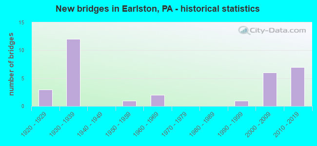
- New bridges - historical statistics
- 31920-1929
- 121930-1939
- 11950-1959
- 21960-1969
- 11990-1999
- 62000-2009
- 72010-2019

- Reconstructed bridges - Historical Statistics
- 11980-1989
- 01990-1999
- 12000-2009
- 22010-2019


- Bridge Condition - Deck
- 11.1%Very good
- 44.4%Good
- 16.7%Satisfactory
- 16.7%Fair
- 11.1%Poor

- Bridge Condition - Superstructure
- 26.3%Very good
- 15.8%Good
- 15.8%Satisfactory
- 26.3%Fair
- 15.8%Poor

- Bridge Condition - Substructure
- 5.3%Very good
- 42.1%Good
- 21.1%Satisfactory
- 21.1%Fair
- 10.5%Poor

- Bridge Condition - Channel
- 23.1%Good
- 23.1%Satisfactory
- 46.2%Fair
- 7.7%Poor

- Bridge Condition - Culverts
- 50.0%Good
- 50.0%Fair
Find on map >> Show street view
Structure Number: 4156, Location: .5 MI.S.OF VALLEYMILL (Lat: 40.021756, Lng: -78.401197), Route carried "on" structure: State highway , Year Built: 1920, Status: Open, Structure Length: 0.91m (2.99ft), Average Daily Traffic: 291 (year 2022), Truck Traffic: 12%, Average Future Daily Traffic: 526 (year 2032), Features Intersected: SNAKESPRING VALLEY RUN, Facility Carried by Structure: SR 1005
Minimum Vertical Clearance: 30+ m (98+ ft), Kilometerpoint: 0.447, Lanes on structure: 2, Owner: State Highway Agency, Approaching Roadway Width: 5.5m (18.0ft), Skew: 1 degrees, Material/Design: Concrete, Design/Construction: Tee Beam, Number Of Spans In Main Unit: 1, Length of Maximum Span: 8.5m (27.9ft), Curb or Sidewalk Widths: Left: 0.2m (0.7ft), Right: 0.2m (0.7ft), Curb-To-Curb Width: 7.0m (23.0ft), Out-to-Out Width: 7.8m (25.6ft)
Condition: Deck: Satisfactory, Superstructure: Satisfactory, Substructure: Satisfactory, Channel: Poor, Operating Rating: 46.3 metric tons, Method Used To Determine Operating Rating: Load Factor (LF), Inventory Rating: 28.1 metric tons, Method Used To Determine Inventory Rating: Load Factor (LF), Structural Evaluation: Equal to present minimum criteria, Deck Geometry: Meets minimum limits, Waterway Adequacy: Equal to present desirable criteria, Approach Roadway Alignment: Better than present minimum criteria, Length Of Structure Improvement: 1.60m (5.25ft), Designated Inspection Frequency: Every 24 months, Inspection Date: March 2021, Deck Structure Type: Concrete Cast-file-Place, Wearing Surface/Protective System: Wearing Surface: Bituminous
Find on map >> Show street view
Structure Number: 4259, Location: 3.5 MI.S.OF EVERETT (Lat: 39.959794, Lng: -78.412397), Route carried "on" structure: State highway , Year Built: 1952, Status: Open, Structure Length: 0.73m (2.40ft), Average Daily Traffic: 803 (year 2022), Truck Traffic: 4%, Average Future Daily Traffic: 845 (year 2032), Design Load: H 20, Features Intersected: CLEAR CREEK, Facility Carried by Structure: SR 2015
Minimum Vertical Clearance: 30+ m (98+ ft), Kilometerpoint: 13.227, Lanes on structure: 2, Owner: State Highway Agency, Approaching Roadway Width: 6.7m (22.0ft), Material/Design: Steel, Design/Construction: Stringer/Multi-beam, Number Of Spans In Main Unit: 1, Length of Maximum Span: 6.4m (21.0ft), Curb or Sidewalk Widths: Left: 0.2m (0.7ft), Right: 0.2m (0.7ft), Curb-To-Curb Width: 7.3m (24.0ft), Out-to-Out Width: 7.9m (25.9ft)
Condition: Deck: Good, Superstructure: Fair, Substructure: Satisfactory, Channel: Fair, Operating Rating: 64.4 metric tons, Method Used To Determine Operating Rating: Load Factor (LF), Inventory Rating: 38.1 metric tons, Method Used To Determine Inventory Rating: Load Factor (LF), Structural Evaluation: Somewhat better than minimum adequacy, Deck Geometry: Meets minimum limits, Waterway Adequacy: Equal to present minimum criteria, Approach Roadway Alignment: Meets minimum limits, Length Of Structure Improvement: 1.30m (4.27ft), Designated Inspection Frequency: Every 24 months, Inspection Date: Febuary 2021, Deck Structure Type: Closed Grating, Wearing Surface/Protective System: Wearing Surface: Bituminous
Find on map >> Show street view
Structure Number: 4271, Location: 1/4 MI E OF OTT TOWN (Lat: 39.978883, Lng: -78.440478), Route carried "on" structure: State highway , Year Built: 1962, Year Reconstructed: 2010, Status: Open, Structure Length: 2.53m (8.30ft), Average Daily Traffic: 19 (year 2018), Truck Traffic: 21%, Average Future Daily Traffic: 46 (year 2032), Design Load: HS 20, Features Intersected: COVE CREEK, Facility Carried by Structure: SR 2023
Minimum Vertical Clearance: 30+ m (98+ ft), Kilometerpoint: 0.492, Lanes on structure: 2, Owner: State Highway Agency, Approaching Roadway Width: 5.5m (18.0ft), Material/Design: Prestressed concrete, Design/Construction: Box Beam or Girders - Multiple, Number Of Spans In Main Unit: 1, Length of Maximum Span: 25.0m (82.0ft), Curb-To-Curb Width: 8.5m (27.9ft), Out-to-Out Width: 10.2m (33.5ft)
Condition: Deck: Good, Superstructure: Fair, Substructure: Good, Channel: Satisfactory, Operating Rating: 98.0 metric tons, Method Used To Determine Operating Rating: Load Factor (LF), Inventory Rating: 22.7 metric tons, Method Used To Determine Inventory Rating: Load Factor (LF), Structural Evaluation: Somewhat better than minimum adequacy, Deck Geometry: Better than present minimum criteria, Waterway Adequacy: Equal to present desirable criteria, Approach Roadway Alignment: Equal to present desirable criteria, Length Of Structure Improvement: 3.30m (10.83ft), Designated Inspection Frequency: Every 24 months, Inspection Date: March 2021, Deck Structure Type: Concrete Cast-file-Place, Wearing Surface/Protective System: Wearing Surface: Monolithic Concrete, Deck Protection: Epoxy Coated Reinforcing
Find on map >> Show street view
Structure Number: 4275, Location: 3.5 MI.S.OF EVERETT (Lat: 39.959719, Lng: -78.404169), Route carried "on" structure: State highway , Year Built: 1965, Year Reconstructed: 2010, Status: Open, Structure Length: 1.71m (5.61ft), Average Daily Traffic: 101 (year 2020), Truck Traffic: 8%, Average Future Daily Traffic: 257 (year 2032), Design Load: HS 20, Features Intersected: CLEAR CREEK, Facility Carried by Structure: SR 2025
Minimum Vertical Clearance: 30+ m (98+ ft), Kilometerpoint: 0.644, Lanes on structure: 2, Owner: State Highway Agency, Approaching Roadway Width: 6.7m (22.0ft), Skew: 2 degrees, Material/Design: Prestressed concrete, Design/Construction: Box Beam or Girders - Multiple, Number Of Spans In Main Unit: 1, Length of Maximum Span: 16.8m (55.1ft), Curb-To-Curb Width: 9.1m (29.9ft), Out-to-Out Width: 10.8m (35.4ft)
Condition: Deck: Good, Superstructure: Satisfactory, Substructure: Satisfactory, Channel: Fair, Operating Rating: 86.2 metric tons, Method Used To Determine Operating Rating: Load Factor (LF), Inventory Rating: 31.8 metric tons, Method Used To Determine Inventory Rating: Load Factor (LF), Structural Evaluation: Equal to present minimum criteria, Deck Geometry: Equal to present minimum criteria, Waterway Adequacy: Better than present minimum criteria, Approach Roadway Alignment: Equal to present desirable criteria, Length Of Structure Improvement: 2.40m (7.87ft), Designated Inspection Frequency: Every 24 months, Inspection Date: Febuary 2021, Deck Structure Type: Concrete Cast-file-Place, Wearing Surface/Protective System: Wearing Surface: Monolithic Concrete, Deck Protection: Epoxy Coated Reinforcing
Find on map >> Show street view
Structure Number: 4276, Location: 2.5 MI.S.OF EVERETT (Lat: 39.969872, Lng: -78.394881), Route carried "on" structure: State highway , Year Built: 1926, Status: Open, Structure Length: 0.82m (2.69ft), Average Daily Traffic: 101 (year 2020), Truck Traffic: 8%, Average Future Daily Traffic: 257 (year 2032), Features Intersected: MILK & WATER CREEK, Facility Carried by Structure: SR 2025
Minimum Vertical Clearance: 30+ m (98+ ft), Kilometerpoint: 2.076, Lanes on structure: 1, Owner: State Highway Agency, Approaching Roadway Width: 4.6m (15.1ft), Skew: 1 degrees, Material/Design: Concrete continuous, Design/Construction: Stringer/Multi-beam, Number Of Spans In Main Unit: 1, Length of Maximum Span: 7.6m (24.9ft), Curb or Sidewalk Widths: Left: 0.2m (0.7ft), Right: 0.2m (0.7ft), Curb-To-Curb Width: 4.7m (15.4ft), Out-to-Out Width: 5.3m (17.4ft)
Condition: Deck: Fair, Superstructure: Fair, Substructure: Fair, Channel: Satisfactory, Operating Rating: 78.0 metric tons, Method Used To Determine Operating Rating: Field evaluation and documented engineering judgment, Inventory Rating: 46.3 metric tons, Method Used To Determine Inventory Rating: Field evaluation and documented engineering judgment, Structural Evaluation: Somewhat better than minimum adequacy, Deck Geometry: High priority of replacement, Waterway Adequacy: Equal to present desirable criteria, Approach Roadway Alignment: Equal to present minimum criteria, Length Of Structure Improvement: 1.00m (3.28ft), Designated Inspection Frequency: Every 24 months, Inspection Date: Febuary 2021, Bridge Improvement Cost: $42,000, Roadway Improvement Cost: $243,000, Total Project Cost: $567,000, Deck Structure Type: Concrete Cast-file-Place, Wearing Surface/Protective System: Wearing Surface: Bituminous, Membrane: Preformed Fabric
Find on map >> Show street view
Structure Number: 4277, Location: 2.25 MI.S.OF EVERETT (Lat: 39.974800, Lng: -78.391633), Route carried "on" structure: State highway , Year Built: 1937, Year Reconstructed: 2008, Status: Open, Structure Length: 1.95m (6.40ft), Average Daily Traffic: 101 (year 2020), Truck Traffic: 8%, Average Future Daily Traffic: 257 (year 2032), Design Load: H 15, Features Intersected: CLEAR CREEK, Facility Carried by Structure: SR 2025
Minimum Vertical Clearance: 30+ m (98+ ft), Kilometerpoint: 2.705, Lanes on structure: 2, Owner: State Highway Agency, Approaching Roadway Width: 6.1m (20.0ft), Skew: 1 degrees, Material/Design: Steel, Design/Construction: Stringer/Multi-beam, Number Of Spans In Main Unit: 1, Length of Maximum Span: 18.0m (59.1ft), Curb-To-Curb Width: 5.6m (18.4ft), Out-to-Out Width: 6.1m (20.0ft)
Condition: Deck: Fair, Superstructure: Poor, Substructure: Fair, Channel: Fair, Operating Rating: 46.3 metric tons, Method Used To Determine Operating Rating: Load Factor (LF), Inventory Rating: 27.2 metric tons, Method Used To Determine Inventory Rating: Load Factor (LF), Structural Evaluation: Meets minimum limits, Deck Geometry: High priority of corrective action, Waterway Adequacy: Equal to present desirable criteria, Approach Roadway Alignment: Meets minimum limits, Length Of Structure Improvement: 2.30m (7.55ft), Designated Inspection Frequency: Every 24 months, Other Special Inspection Frequency: Every 12 months, Inspection Date: May 2021, Other Special Inspection Date: May 2021, Bridge Improvement Cost: $66,000, Roadway Improvement Cost: $264,000, Total Project Cost: $885,000, Deck Structure Type: Open Grating
Find on map >> Show street view
Structure Number: 443, Location: LUTZVILLE (Lat: 40.005203, Lng: -78.434472), Route carried "on" structure: Interstate 76, Year Built: 1939, Year Reconstructed: 1987, Status: Open, Structure Length: 0.85m (2.79ft), Average Daily Traffic: 36,252 (year 2004), Truck Traffic: 33%, Average Future Daily Traffic: 40,900 (year 2030), Design Load: HS 20, Features Intersected: SR 2019(LR 05036)
Minimum Vertical Clearance: 30+ m (98+ ft), Kilometerpoint: 0.000, Lanes on structure: 4, Lanes under structure: 2, Base Highway Network: Yes, Toll: On toll road, Owner: State Toll Authority, Approaching Roadway Width: 22.3m (73.2ft), Skew: 32 degrees, Material/Design: Prestressed concrete, Design/Construction: Box Beam or Girders - Multiple, Number Of Spans In Main Unit: 1, Length of Maximum Span: 7.6m (24.9ft), Curb or Sidewalk Widths: Left: 0.2m (0.7ft), Right: 0.2m (0.7ft), Curb-To-Curb Width: 24.6m (80.7ft), Out-to-Out Width: 25.6m (84.0ft)
Condition: Deck: Satisfactory, Superstructure: Poor, Substructure: Fair, Operating Rating: 63.5 metric tons, Method Used To Determine Operating Rating: Load Factor (LF), Inventory Rating: 35.4 metric tons, Method Used To Determine Inventory Rating: Load Factor (LF), Structural Evaluation: Meets minimum limits, Deck Geometry: Superior to present desirable criteria, Underclear: High priority of corrective action, Approach Roadway Alignment: Equal to present desirable criteria, Length Of Structure Improvement: 1.50m (4.92ft), Designated Inspection Frequency: Every 24 months, Inspection Date: September 2020, Deck Structure Type: Other, Wearing Surface/Protective System: Wearing Surface: Latex Concrete
Find on map >> Show street view
Structure Number: 4432, Location: ASHCOM (Lat: 40.003542, Lng: -78.420297), Route carried "on" structure: Interstate 76, Year Built: 1939, Status: Open, Structure Length: 3.51m (11.52ft), Average Daily Traffic: 36,252 (year 2004), Truck Traffic: 33%, Average Future Daily Traffic: 40,900 (year 2030), Design Load: HS 20, Features Intersected: COVE CREEK
Minimum Vertical Clearance: 30+ m (98+ ft), Kilometerpoint: 0.000, Lanes on structure: 4, Base Highway Network: Yes, Toll: On toll road, Owner: State Toll Authority, Approaching Roadway Width: 23.2m (76.1ft), Skew: 31 degrees, Material/Design: Concrete, Design/Construction: Culvert, Number Of Spans In Main Unit: 2, Length of Maximum Span: 15.8m (51.8ft)
Condition: Channel: Fair, Culverts: Fair, Operating Rating: 71.7 metric tons, Method Used To Determine Operating Rating: Load Factor (LF), Inventory Rating: 42.6 metric tons, Method Used To Determine Inventory Rating: Load Factor (LF), Structural Evaluation: Somewhat better than minimum adequacy, Waterway Adequacy: Superior to present desirable criteria, Approach Roadway Alignment: Equal to present desirable criteria, Length Of Structure Improvement: 4.40m (14.44ft), Designated Inspection Frequency: Every 24 months, Inspection Date: September 2020, Bridge Improvement Cost: $72,000, Roadway Improvement Cost: $212,000, Total Project Cost: $973,000
Find on map >> Show street view
Structure Number: 4435, Location: NEAR ASHCOM (Lat: 40.003333, Lng: -78.408333), Route carried "on" structure: Interstate 76, Year Built: 1939, Status: Open, Structure Length: 1.43m (4.69ft), Average Daily Traffic: 36,252 (year 2004), Truck Traffic: 33%, Average Future Daily Traffic: 40,900 (year 2030), Design Load: HS 20, Features Intersected: SR 1004 (LR 05039)
Minimum Vertical Clearance: 30+ m (98+ ft), Kilometerpoint: 0.000, Lanes on structure: 4, Lanes under structure: 2, Base Highway Network: Yes, Toll: On toll road, Owner: State Toll Authority, Approaching Roadway Width: 25.0m (82.0ft), Skew: 36 degrees, Material/Design: Concrete, Design/Construction: Tee Beam, Number Of Spans In Main Unit: 1, Length of Maximum Span: 13.4m (44.0ft), Curb or Sidewalk Widths: Left: 0.2m (0.7ft), Right: 0.2m (0.7ft), Curb-To-Curb Width: 20.9m (68.6ft), Out-to-Out Width: 22.3m (73.2ft)
Condition: Deck: Poor, Superstructure: Fair, Substructure: Fair, Operating Rating: 42.6 metric tons, Method Used To Determine Operating Rating: Load Factor (LF), Inventory Rating: 25.4 metric tons, Method Used To Determine Inventory Rating: Load Factor (LF), Structural Evaluation: Somewhat better than minimum adequacy, Deck Geometry: Better than present minimum criteria, Underclear: High priority of corrective action, Approach Roadway Alignment: Equal to present desirable criteria, Length Of Structure Improvement: 2.10m (6.89ft), Designated Inspection Frequency: Every 24 months, Inspection Date: September 2020, Bridge Improvement Cost: $70,000, Roadway Improvement Cost: $205,000, Total Project Cost: $940,000, Deck Structure Type: Concrete Cast-file-Place, Wearing Surface/Protective System: Wearing Surface: Bituminous
Find on map >> Show street view
Structure Number: 4438, Location: EVERETT (Lat: 40.003333, Lng: -78.385000), Route carried "on" structure: Interstate 70, Year Built: 1939, Status: Open, Structure Length: 1.04m (3.41ft), Average Daily Traffic: 35,070 (year 2008), Truck Traffic: 33%, Average Future Daily Traffic: 44,710 (year 2030), Design Load: HS 20, Features Intersected: SR 1004, LR 05018, Facility Carried by Structure: PA TPK (I-76)
Minimum Vertical Clearance: 30+ m (98+ ft), Kilometerpoint: 248.386, Lanes on structure: 4, Lanes under structure: 2, Base Highway Network: Yes, Toll: On toll road, Owner: State Toll Authority, Approaching Roadway Width: 21.3m (69.9ft), Skew: 32 degrees, Material/Design: Concrete, Design/Construction: Slab, Number Of Spans In Main Unit: 1, Length of Maximum Span: 8.8m (28.9ft)
Condition: Superstructure: Satisfactory, Substructure: Satisfactory, Inventory Rating: 75.3 metric tons, Method Used To Determine Inventory Rating: Load Factor (LF), Structural Evaluation: Equal to present minimum criteria, Underclear: High priority of corrective action, Approach Roadway Alignment: Equal to present desirable criteria, Length Of Structure Improvement: 1.70m (5.58ft), Designated Inspection Frequency: Every 48 months, Inspection Date: September 2018, Bridge Improvement Cost: $6,000, Roadway Improvement Cost: $19,000, Total Project Cost: $86,000
Find on map >> Show street view
Structure Number: 4445, Location: 0.25 M.N.SR2020 (Lat: 40.000806, Lng: -78.351256), Route carried "on" structure: State highway , Year Built: 1939, Status: Open, Structure Length: 2.87m (9.42ft), Average Daily Traffic: 87 (year 2021), Truck Traffic: 9%, Average Future Daily Traffic: 81 (year 2030), Design Load: HS 20, Features Intersected: PA TPK (I-76), Facility Carried by Structure: SR 1006 (LR 05113)
Minimum Vertical Clearance: 30+ m (98+ ft), Kilometerpoint: 0.636, Lanes on structure: 2, Lanes under structure: 4, Owner: State Toll Authority, Approaching Roadway Width: 7.3m (24.0ft), Skew: 2 degrees, Material/Design: Concrete, Design/Construction: Frame, Number Of Spans In Main Unit: 1, Length of Maximum Span: 25.3m (83.0ft), Curb or Sidewalk Widths: Left: 0.2m (0.7ft), Right: 0.2m (0.7ft), Curb-To-Curb Width: 6.1m (20.0ft), Out-to-Out Width: 7.0m (23.0ft)
Condition: Deck: Poor, Superstructure: Poor, Substructure: Poor, Operating Rating: 58.1 metric tons, Method Used To Determine Operating Rating: Load Factor (LF), Inventory Rating: 34.5 metric tons, Method Used To Determine Inventory Rating: Load Factor (LF), Structural Evaluation: Meets minimum limits, Deck Geometry: Somewhat better than minimum adequacy, Underclear: High priority of corrective action, Approach Roadway Alignment: Equal to present desirable criteria, Length Of Structure Improvement: 3.60m (11.81ft), Designated Inspection Frequency: Every 24 months, Inspection Date: September 2020, Bridge Improvement Cost: $29,000, Roadway Improvement Cost: $86,000, Total Project Cost: $395,000, Wearing Surface/Protective System: Wearing Surface: Bituminous
Find on map >> Show street view
Structure Number: 4517, Location: 4.5 MI.SW.OF EVERETT (Lat: 39.952433, Lng: -78.410139), Route carried "on" structure: City street , Year Built: 1928, Status: Open, Structure Length: 1.07m (3.51ft), Average Daily Traffic: 50 (year 2021), Average Future Daily Traffic: 63 (year 2041), Features Intersected: CLEAR CREEK, Facility Carried by Structure: T352,Elk Lick Road
Minimum Vertical Clearance: 30+ m (98+ ft), Kilometerpoint: 0.000, Lanes on structure: 2, Owner: Town or Township Highway Agency, Approaching Roadway Width: 4.6m (15.1ft), Material/Design: Concrete, Design/Construction: Tee Beam, Number Of Spans In Main Unit: 1, Length of Maximum Span: 10.4m (34.1ft), Curb or Sidewalk Widths: Left: 0.1m (0.3ft), Right: 0.1m (0.3ft), Curb-To-Curb Width: 4.9m (16.1ft), Out-to-Out Width: 5.5m (18.0ft)
Condition: Deck: Fair, Superstructure: Fair, Substructure: Poor, Channel: Fair, Operating Rating: 49.0 metric tons, Method Used To Determine Operating Rating: Field evaluation and documented engineering judgment, Inventory Rating: 32.7 metric tons, Method Used To Determine Inventory Rating: Field evaluation and documented engineering judgment, Structural Evaluation: Meets minimum limits, Waterway Adequacy: Equal to present desirable criteria, Approach Roadway Alignment: Somewhat better than minimum adequacy, Length Of Structure Improvement: 1.30m (4.27ft), Designated Inspection Frequency: Every 24 months, Inspection Date: March 2021, Bridge Improvement Cost: $49,000, Roadway Improvement Cost: $264,000, Total Project Cost: $666,000, Deck Structure Type: Concrete Cast-file-Place, Wearing Surface/Protective System: Wearing Surface: Bituminous
Find on map >> Show street view
Structure Number: 42183, Location: 2 MILES EAST OF BEDFORD (Lat: 40.022197, Lng: -78.423936), Route carried "on" structure: US 30, Year Built: 2003, Status: Open, Structure Length: 3.69m (12.11ft), Average Daily Traffic: 12,813 (year 2020), Truck Traffic: 17%, Average Future Daily Traffic: 18,191 (year 2032), Design Load: HL 93, Features Intersected: SR 2019
Minimum Vertical Clearance: 30+ m (98+ ft), Kilometerpoint: 33.494, Lanes on structure: 4, Lanes under structure: 2, Base Highway Network: Yes, Owner: State Highway Agency, Approaching Roadway Width: 35.4m (116.1ft), Skew: 1 degrees, Material/Design: Prestressed concrete, Design/Construction: Stringer/Multi-beam, Number Of Spans In Main Unit: 1, Length of Maximum Span: 36.0m (118.1ft), Curb or Sidewalk Widths: Left: 0.2m (0.7ft), Right: 0.2m (0.7ft), Curb-To-Curb Width: 35.6m (116.8ft), Out-to-Out Width: 36.4m (119.4ft)
Condition: Deck: Satisfactory, Superstructure: Good, Substructure: Good, Operating Rating: 83.5 metric tons, Method Used To Determine Operating Rating: Load and Resistance Factor (LRFR), Inventory Rating: 45.4 metric tons, Method Used To Determine Inventory Rating: Load and Resistance Factor (LRFR), Structural Evaluation: Better than present minimum criteria, Deck Geometry: Superior to present desirable criteria, Underclear: Somewhat better than minimum adequacy, Approach Roadway Alignment: Equal to present desirable criteria, Length Of Structure Improvement: 4.60m (15.09ft), Designated Inspection Frequency: Every 48 months, Inspection Date: June 2019, Deck Structure Type: Concrete Cast-file-Place, Wearing Surface/Protective System: Wearing Surface: Monolithic Concrete, Deck Protection: Epoxy Coated Reinforcing
Find on map >> Show street view
Structure Number: 42207, Location: 2 MILES EAST OF BEDFORD (Lat: 40.024656, Lng: -78.436558), Route carried "on" structure: State highway , Year Built: 2003, Status: Open, Structure Length: 4.69m (15.39ft), Average Daily Traffic: 637 (year 2020), Truck Traffic: 6%, Average Future Daily Traffic: 684 (year 2032), Design Load: HS 25 or greater, Features Intersected: US 30, Facility Carried by Structure: SR 1003
Minimum Vertical Clearance: 30+ m (98+ ft), Kilometerpoint: 0.000, Lanes on structure: 2, Lanes under structure: 6, Owner: State Highway Agency, Approaching Roadway Width: 12.2m (40.0ft), Skew: 1 degrees, Material/Design: Prestressed concrete, Design/Construction: Stringer/Multi-beam, Number Of Spans In Main Unit: 1, Length of Maximum Span: 46.3m (151.9ft), Curb or Sidewalk Widths: Left: 0.2m (0.7ft), Right: 0.2m (0.7ft), Curb-To-Curb Width: 12.0m (39.4ft), Out-to-Out Width: 12.9m (42.3ft)
Condition: Deck: Good, Superstructure: Very good, Substructure: Good, Inventory Rating: 37.2 metric tons, Method Used To Determine Inventory Rating: Load Factor (LF), Structural Evaluation: Better than present minimum criteria, Deck Geometry: Better than present minimum criteria, Underclear: Superior to present desirable criteria, Approach Roadway Alignment: Equal to present desirable criteria, Length Of Structure Improvement: 5.60m (18.37ft), Designated Inspection Frequency: Every 48 months, Inspection Date: May 2019, Deck Structure Type: Concrete Cast-file-Place, Wearing Surface/Protective System: Wearing Surface: Epoxy Overlay, Deck Protection: Epoxy Coated Reinforcing
Find on map >> Show street view
Structure Number: 42281, Location: 1 MILE WEST OF EVERETT (Lat: 40.017539, Lng: -78.401319), Route carried "on" structure: US 30, Year Built: 2003, Status: Open, Structure Length: 1.52m (4.99ft), Average Daily Traffic: 13,653 (year 2020), Truck Traffic: 16%, Average Future Daily Traffic: 19,813 (year 2032), Design Load: HS 25 or greater, Features Intersected: SNAKE SPRING VALLEY RUN
Minimum Vertical Clearance: 30+ m (98+ ft), Kilometerpoint: 35.499, Lanes on structure: 4, Base Highway Network: Yes, Owner: State Highway Agency, Approaching Roadway Width: 24.1m (79.1ft), Skew: 1 degrees, Material/Design: Prestressed concrete, Design/Construction: Box Beam or Girders - Single/Spread, Number Of Spans In Main Unit: 1, Length of Maximum Span: 14.6m (47.9ft), Curb or Sidewalk Widths: Left: 0.2m (0.7ft), Right: 0.2m (0.7ft), Curb-To-Curb Width: 23.1m (75.8ft), Out-to-Out Width: 23.9m (78.4ft)
Condition: Deck: Good, Superstructure: Very good, Substructure: Good, Channel: Satisfactory, Operating Rating: 71.7 metric tons, Method Used To Determine Operating Rating: Load Factor (LF), Inventory Rating: 42.6 metric tons, Method Used To Determine Inventory Rating: Load Factor (LF), Structural Evaluation: Better than present minimum criteria, Deck Geometry: Superior to present desirable criteria, Waterway Adequacy: Equal to present desirable criteria, Approach Roadway Alignment: Equal to present desirable criteria, Length Of Structure Improvement: 1.50m (4.92ft), Designated Inspection Frequency: Every 48 months, Inspection Date: May 2019, Deck Structure Type: Concrete Cast-file-Place, Wearing Surface/Protective System: Wearing Surface: Monolithic Concrete, Deck Protection: Epoxy Coated Reinforcing
Find on map >> Show street view
Structure Number: 46724, Location: .25 MI.S.OF VALLEYMILL (Lat: 40.030119, Lng: -78.401819), Route carried "on" structure: State highway , Year Built: 2011, Status: Open, Structure Length: 2.26m (7.41ft), Average Daily Traffic: 291 (year 2022), Truck Traffic: 12%, Average Future Daily Traffic: 526 (year 2032), Design Load: HL 93, Features Intersected: SNAKESPRING VALLEY RUN, Facility Carried by Structure: SR 1005
Minimum Vertical Clearance: 30+ m (98+ ft), Kilometerpoint: 1.389, Lanes on structure: 2, Owner: State Highway Agency, Approaching Roadway Width: 5.8m (19.0ft), Skew: 2 degrees, Material/Design: Prestressed concrete, Design/Construction: Box Beam or Girders - Single/Spread, Number Of Spans In Main Unit: 1, Length of Maximum Span: 21.9m (71.9ft), Curb or Sidewalk Widths: Left: 0.2m (0.7ft), Right: 0.2m (0.7ft), Curb-To-Curb Width: 7.9m (25.9ft), Out-to-Out Width: 9.0m (29.5ft)
Condition: Deck: Very good, Superstructure: Very good, Substructure: Good, Channel: Good, Operating Rating: 64.8 metric tons, Method Used To Determine Operating Rating: Assigned ratings based on Load and Resistance Factor Design (LRFD) reported by rating factor (RF) using HL93 loadings, Inventory Rating: 35.3 metric tons, Method Used To Determine Inventory Rating: Assigned ratings based on Load and Resistance Factor Design (LRFD) reported by rating factor (RF) using HL93 loadings, Structural Evaluation: Better than present minimum criteria, Deck Geometry: Somewhat better than minimum adequacy, Waterway Adequacy: Better than present minimum criteria, Approach Roadway Alignment: Equal to present desirable criteria, Length Of Structure Improvement: 2.26m (7.41ft), Designated Inspection Frequency: Every 24 months, Inspection Date: Febuary 2021, Deck Structure Type: Concrete Cast-file-Place, Wearing Surface/Protective System: Wearing Surface: Monolithic Concrete, Deck Protection: Epoxy Coated Reinforcing
Find on map >> Show street view
Structure Number: 47297, Location: OVER TP (MP 150.9) B-443 (Lat: 40.005228, Lng: -78.434406), Route carried "on" structure: State highway , Year Built: 2011, Status: Open, Structure Length: 7.10m (23.29ft), Average Daily Traffic: 540 (year 2020), Truck Traffic: 34%, Average Future Daily Traffic: 799 (year 2032), Design Load: HL 93, Features Intersected: I-70 & I-76, Facility Carried by Structure: SR 1004 (LR 05039)
Minimum Vertical Clearance: 30+ m (98+ ft), Kilometerpoint: 0.000, Lanes on structure: 2, Lanes under structure: 4, Owner: State Highway Agency, Approaching Roadway Width: 7.9m (25.9ft), Skew: 4 degrees, Material/Design: Steel continuous, Design/Construction: Stringer/Multi-beam, Number Of Spans In Main Unit: 2, Length of Maximum Span: 35.1m (115.2ft), Curb or Sidewalk Widths: Left: 0.2m (0.7ft), Right: 0.2m (0.7ft), Curb-To-Curb Width: 9.8m (32.2ft), Out-to-Out Width: 10.8m (35.4ft)
Condition: Deck: Good, Superstructure: Good, Substructure: Good, Operating Rating: 62.2 metric tons, Method Used To Determine Operating Rating: Assigned ratings based on Load and Resistance Factor Design (LRFD) reported by rating factor (RF) using HL93 loadings, Inventory Rating: 44.7 metric tons, Method Used To Determine Inventory Rating: Assigned ratings based on Load and Resistance Factor Design (LRFD) reported by rating factor (RF) using HL93 loadings, Structural Evaluation: Better than present minimum criteria, Deck Geometry: Equal to present minimum criteria, Underclear: Superior to present desirable criteria, Approach Roadway Alignment: Equal to present desirable criteria, Designated Inspection Frequency: Every 48 months, Inspection Date: April 2019, Deck Structure Type: Concrete Cast-file-Place, Wearing Surface/Protective System: Wearing Surface: Monolithic Concrete, Deck Protection: Epoxy Coated Reinforcing
Find on map >> Show street view
Structure Number: 47298, Location: Near Everett (Lat: 40.001667, Lng: -78.370000), Route carried "on" structure: Other road , Year Built: 2011, Status: Open, Structure Length: 6.58m (21.59ft), Average Daily Traffic: 30 (year 2012), Truck Traffic: 10%, Average Future Daily Traffic: 40 (year 2030), Design Load: HL 93, Features Intersected: PA TPK (I-76), Facility Carried by Structure: Private Lane
Minimum Vertical Clearance: 30+ m (98+ ft), Kilometerpoint: 0.000, Lanes on structure: 1, Lanes under structure: 4, Owner: State Toll Authority, Approaching Roadway Width: 3.7m (12.1ft), Material/Design: Steel continuous, Design/Construction: Stringer/Multi-beam, Number Of Spans In Main Unit: 2, Length of Maximum Span: 36.3m (119.1ft), Curb or Sidewalk Widths: Left: 0.2m (0.7ft), Right: 0.2m (0.7ft), Curb-To-Curb Width: 3.7m (12.1ft), Out-to-Out Width: 4.7m (15.4ft)
Condition: Deck: Good, Superstructure: Very good, Substructure: Very good, Operating Rating: 54.8 metric tons, Method Used To Determine Operating Rating: Assigned ratings based on Load and Resistance Factor Design (LRFD) reported by rating factor (RF) using HL93 loadings, Inventory Rating: 34.3 metric tons, Method Used To Determine Inventory Rating: Assigned ratings based on Load and Resistance Factor Design (LRFD) reported by rating factor (RF) using HL93 loadings, Structural Evaluation: Equal to present desirable criteria, Deck Geometry: Meets minimum limits, Underclear: Equal to present minimum criteria, Approach Roadway Alignment: Equal to present minimum criteria, Designated Inspection Frequency: Every 24 months, Critical Feature Inspection Frequency: Every 24 months, Inspection Date: September 2020, Critical Feature Inspection Date: September 2020, Deck Structure Type: Concrete Cast-file-Place, Wearing Surface/Protective System: Wearing Surface: Monolithic Concrete, Deck Protection: Epoxy Coated Reinforcing
Find on map >> Show street view
Structure Number: 48393, Location: ASHCOM (Lat: 40.005586, Lng: -78.422606), Route carried "on" structure: State highway , Year Built: 2013, Status: Open, Structure Length: 3.57m (11.71ft), Average Daily Traffic: 540 (year 2020), Truck Traffic: 34%, Average Future Daily Traffic: 778 (year 2034), Design Load: HL 93, Features Intersected: COVE CREEK, Facility Carried by Structure: SR 1004
Minimum Vertical Clearance: 30+ m (98+ ft), Kilometerpoint: 0.610, Lanes on structure: 2, Owner: State Highway Agency, Approaching Roadway Width: 8.5m (27.9ft), Skew: 1 degrees, Material/Design: Prestressed concrete, Design/Construction: Stringer/Multi-beam, Number Of Spans In Main Unit: 1, Length of Maximum Span: 35.4m (116.1ft), Curb or Sidewalk Widths: Left: 0.2m (0.7ft), Right: 0.2m (0.7ft), Curb-To-Curb Width: 8.5m (27.9ft), Out-to-Out Width: 9.6m (31.5ft)
Condition: Deck: Very good, Superstructure: Very good, Substructure: Good, Channel: Good, Operating Rating: 74.2 metric tons, Method Used To Determine Operating Rating: Assigned ratings based on Load and Resistance Factor Design (LRFD) reported by rating factor (RF) using HL93 loadings, Inventory Rating: 37.9 metric tons, Method Used To Determine Inventory Rating: Assigned ratings based on Load and Resistance Factor Design (LRFD) reported by rating factor (RF) using HL93 loadings, Structural Evaluation: Better than present minimum criteria, Deck Geometry: Somewhat better than minimum adequacy, Waterway Adequacy: Better than present minimum criteria, Approach Roadway Alignment: Equal to present desirable criteria, Designated Inspection Frequency: Every 48 months, Inspection Date: June 2019, Deck Structure Type: Concrete Precast Panels, Wearing Surface/Protective System: Wearing Surface: Epoxy Overlay, Deck Protection: Epoxy Coated Reinforcing
Find on map >> Show street view
Structure Number: 48644, Location: Near Everrett Maint. Shed (Lat: 40.004100, Lng: -78.381006), Route carried "on" structure: ServiceInterstate T, Year Built: 2014, Status: Open, Structure Length: 0.64m (2.10ft), Average Daily Traffic: 50 (year 2018), Truck Traffic: 1%, Average Future Daily Traffic: 75 (year 2028), Design Load: HL 93, Features Intersected: Black Valley Creek
Minimum Vertical Clearance: 30+ m (98+ ft), Kilometerpoint: 0.000, Lanes on structure: 2, Toll: Toll bridge, Owner: State Toll Authority, Approaching Roadway Width: 6.7m (22.0ft), Skew: 1 degrees, Material/Design: Concrete, Design/Construction: Culvert, Number Of Spans In Main Unit: 1, Length of Maximum Span: 6.4m (21.0ft)
Condition: Channel: Good, Culverts: Good, Operating Rating: 97.2 metric tons, Method Used To Determine Operating Rating: Assigned ratings based on Load and Resistance Factor Design (LRFD) reported by rating factor (RF) using HL93 loadings, Inventory Rating: 64.8 metric tons, Method Used To Determine Inventory Rating: Assigned ratings based on Load and Resistance Factor Design (LRFD) reported by rating factor (RF) using HL93 loadings, Structural Evaluation: Better than present minimum criteria, Waterway Adequacy: Better than present minimum criteria, Approach Roadway Alignment: Equal to present desirable criteria, Designated Inspection Frequency: Every 48 months, Inspection Date: September 2018
Find on map >> Show street view
Structure Number: 48854, Location: 1.13 MILE SOUTH FROM US 3 (Lat: 40.008903, Lng: -78.434628), Route carried "on" structure: State highway , Year Built: 2014, Status: Open, Structure Length: 5.33m (17.49ft), Average Daily Traffic: 1,077 (year 2022), Truck Traffic: 5%, Average Future Daily Traffic: 1,200 (year 2034), Design Load: HL 93, Features Intersected: RAYSTOWN BR JUNIATA RIV, Facility Carried by Structure: SR 2019
Minimum Vertical Clearance: 30+ m (98+ ft), Kilometerpoint: 3.727, Lanes on structure: 2, Owner: State Highway Agency, Approaching Roadway Width: 6.7m (22.0ft), Material/Design: Prestressed concrete, Design/Construction: Box Beam or Girders - Single/Spread, Number Of Spans In Main Unit: 3, Length of Maximum Span: 20.4m (66.9ft), Curb-To-Curb Width: 7.3m (24.0ft), Out-to-Out Width: 8.2m (26.9ft)
Condition: Deck: Good, Superstructure: Good, Substructure: Good, Channel: Fair, Operating Rating: 43.7 metric tons, Method Used To Determine Operating Rating: Assigned ratings based on Load and Resistance Factor Design (LRFD) reported by rating factor (RF) using HL93 loadings, Inventory Rating: 33.7 metric tons, Method Used To Determine Inventory Rating: Assigned ratings based on Load and Resistance Factor Design (LRFD) reported by rating factor (RF) using HL93 loadings, Structural Evaluation: Better than present minimum criteria, Deck Geometry: Meets minimum limits, Waterway Adequacy: Better than present minimum criteria, Approach Roadway Alignment: Meets minimum limits, Length Of Structure Improvement: 5.30m (17.39ft), Designated Inspection Frequency: Every 24 months, Inspection Date: September 2021, Deck Structure Type: Concrete Cast-file-Place, Wearing Surface/Protective System: Wearing Surface: Monolithic Concrete, Deck Protection: Galvanized Reinforcing
Find on map >> Show street view
Structure Number: 443, Location: LUTZVILLE (Lat: 40.005203, Lng: -78.434472), Route carried "under" structure: State highway , Year Built: 1939, Structure Length: 0. m, Average Daily Traffic: 1,077 (year 2022), Truck Traffic: 5%, Features Intersected: SR 2019(LR 05036), Facility Carried by Structure: PA TPK (I-70&I-76)
Minimum Vertical Clearance: 4.34m (14.24ft), Kilometerpoint: 3.206, Lanes on structure: 4, Lanes under structure: 2, Material/Design: Prestressed concrete, Design/Construction: Box Beam or Girders - Multiple, Length of Maximum Span: 7.6m (24.9ft)
Find on map >> Show street view
Structure Number: 4434, Location: @ ENTERPRISES ASHCOMQUAR (Lat: 40.001667, Lng: -78.416667), Route carried "under" structure: Other road , Year Built: 1999, Structure Length: 0. m, Average Daily Traffic: 200 (year 1992), Features Intersected: PRIVATE QUARRY RD, Facility Carried by Structure: PA TPK (I-76)
Minimum Vertical Clearance: 5.89m (19.32ft), Kilometerpoint: 0.000, Lanes on structure: 4, Lanes under structure: 2, Toll: On toll road, Material/Design: Prestressed concrete, Design/Construction: Box Beam or Girders - Multiple, Length of Maximum Span: 15.2m (49.9ft)
Find on map >> Show street view
Structure Number: 4435, Location: NEAR ASHCOM (Lat: 40.003333, Lng: -78.408333), Route carried "under" structure: State highway , Year Built: 1939, Structure Length: 0. m, Average Daily Traffic: 540 (year 2020), Truck Traffic: 34%, Features Intersected: SR 1004 (LR 05039), Facility Carried by Structure: PA TPK (I-76)
Minimum Vertical Clearance: 4.15m (13.62ft), Kilometerpoint: 2.176, Lanes on structure: 4, Lanes under structure: 2, Material/Design: Concrete, Design/Construction: Tee Beam, Length of Maximum Span: 13.4m (44.0ft)
Find on map >> Show street view
Structure Number: 4438, Location: EVERETT (Lat: 40.003333, Lng: -78.385000), Route carried "under" structure: State highway , Year Built: 1939, Structure Length: 0. m, Average Daily Traffic: 2,068 (year 2020), Truck Traffic: 8%, Features Intersected: SR 1004, LR 05018, Facility Carried by Structure: PA TPK (I-76)
Minimum Vertical Clearance: 5.80m (19.03ft), Kilometerpoint: 5.121, Lanes on structure: 4, Lanes under structure: 2, Material/Design: Concrete, Design/Construction: Slab, Length of Maximum Span: 8.8m (28.9ft)
Find on map >> Show street view
Structure Number: 444, Location: EVERETT (Lat: 40.002847, Lng: -78.376192), Route carried "under" structure: State highway , Year Built: 1939, Structure Length: 0. m, Average Daily Traffic: 135 (year 2018), Truck Traffic: 9%, Features Intersected: SR 2027(LR 05093);B-519, Facility Carried by Structure: TURNPIKE I-70&I-76
Minimum Vertical Clearance: 4.40m (14.44ft), Kilometerpoint: 0.966, Lanes on structure: 4, Lanes under structure: 2, Material/Design: Concrete, Design/Construction: Tee Beam, Length of Maximum Span: 8.5m (27.9ft)
Find on map >> Show street view
Structure Number: 4441, Location: EVERETT (Lat: 40.002592, Lng: -78.373353), Route carried "under" structure: State highway , Year Built: 1939, Structure Length: 0. m, Average Daily Traffic: 412 (year 2022), Truck Traffic: 13%, Features Intersected: SR 2025, LR 05123, Facility Carried by Structure: PA TPK (I-76)
Minimum Vertical Clearance: 3.55m (11.65ft), Kilometerpoint: 6.217, Lanes on structure: 4, Lanes under structure: 2, Material/Design: Concrete, Design/Construction: Culvert, Length of Maximum Span: 11.0m (36.1ft)
Find on map >> Show street view
Structure Number: 4445, Location: 0.25 M.N.SR2020 (Lat: 40.000806, Lng: -78.351256), Route carried "under" structure: Interstate 76, Year Built: 1939, Structure Length: 0. m, Average Daily Traffic: 33,684 (year 2001), Truck Traffic: 36%, Features Intersected: PA TPK (I-76), Facility Carried by Structure: SR 1006 (LR 05113)
Minimum Vertical Clearance: 4.36m (14.30ft), Kilometerpoint: 251.186, Lanes on structure: 2, Lanes under structure: 4, Material/Design: Concrete, Design/Construction: Frame, Length of Maximum Span: 25.3m (83.0ft)
Find on map >> Show street view
Structure Number: 42183, Location: 2 MILES EAST OF BEDFORD (Lat: 40.022197, Lng: -78.423936), Route carried "under" structure: State highway , Year Built: 2003, Structure Length: 0. m, Average Daily Traffic: 1,077 (year 2022), Truck Traffic: 5%, Features Intersected: SR 2019, Facility Carried by Structure: US 30
Minimum Vertical Clearance: 4.93m (16.17ft), Kilometerpoint: 5.324, Lanes on structure: 4, Lanes under structure: 2, Material/Design: Prestressed concrete, Design/Construction: Stringer/Multi-beam, Length of Maximum Span: 36.0m (118.1ft)
Find on map >> Show street view
Structure Number: 42207, Location: 2 MILES EAST OF BEDFORD (Lat: 40.024656, Lng: -78.436558), Route carried "under" structure: US 30, Year Built: 2003, Structure Length: 0. m, Average Daily Traffic: 8,966 (year 2020), Truck Traffic: 15%, Features Intersected: US 30, Facility Carried by Structure: SR 1003
Minimum Vertical Clearance: 5.13m (16.83ft), Kilometerpoint: 32.399, Lanes on structure: 2, Lanes under structure: 3, Material/Design: Prestressed concrete, Design/Construction: Stringer/Multi-beam, Length of Maximum Span: 46.3m (151.9ft)
Find on map >> Show street view
Structure Number: 42207, Location: 2 MILES EAST OF BEDFORD (Lat: 40.024656, Lng: -78.436558), Route carried "under" structure: US 30, Year Built: 2003, Structure Length: 0. m, Average Daily Traffic: 6,170 (year 2020), Truck Traffic: 19%, Features Intersected: US 30, Facility Carried by Structure: SR 1003
Minimum Vertical Clearance: 5.23m (17.16ft), Kilometerpoint: 32.414, Lanes on structure: 2, Lanes under structure: 3, Material/Design: Prestressed concrete, Design/Construction: Stringer/Multi-beam, Length of Maximum Span: 46.3m (151.9ft)
Find on map >> Show street view
Structure Number: 47297, Location: OVER TP (MP 150.9) B-443 (Lat: 40.005228, Lng: -78.434406), Route carried "under" structure: Interstate 76, Year Built: 2011, Structure Length: 0. m, Average Daily Traffic: 36,252 (year 2004), Truck Traffic: 33%, Features Intersected: I-70 & I-76, Facility Carried by Structure: SR 1004 (LR 05039)
Minimum Vertical Clearance: 5.28m (17.32ft), Kilometerpoint: 0.000, Lanes on structure: 2, Lanes under structure: 4, Toll: On toll road, Material/Design: Steel continuous, Design/Construction: Stringer/Multi-beam, Length of Maximum Span: 35.1m (115.2ft)