Bridge Statistics for Eagle, Colorado (CO)
Condition, Traffic, Stress, Structural Evaluation, Project Costs
- National Bridge Inventory (NBI) Statistics
- 14Number of bridges
- 112ft / 33.6mTotal length
- $317,000Total costs
- 85,111Total average daily traffic
- 5,802Total average daily truck traffic
- National Bridge Inventory (NBI) Registered Bridges for Eagle
- No street view available for this location
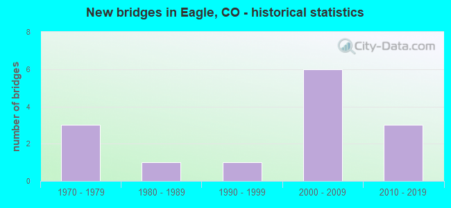
- New bridges - historical statistics
- 31970-1979
- 11980-1989
- 11990-1999
- 62000-2009
- 32010-2019
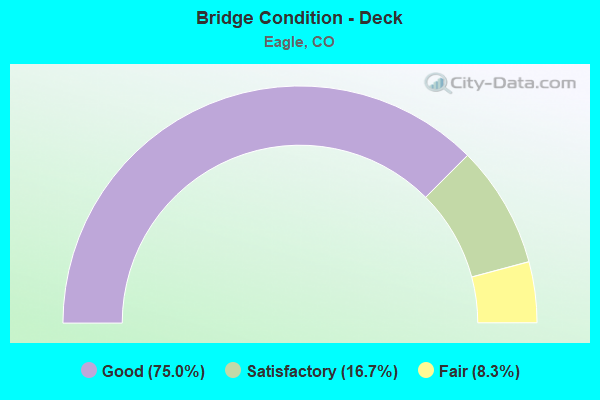
- Bridge Condition - Deck
- 75.0%Good
- 16.7%Satisfactory
- 8.3%Fair
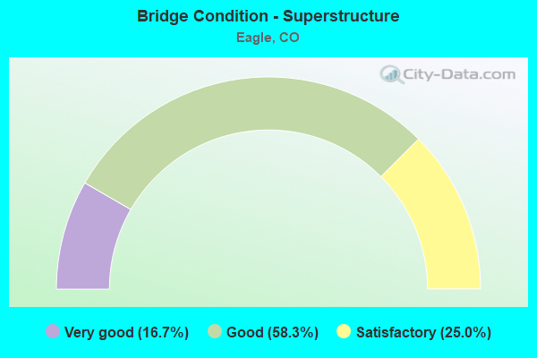
- Bridge Condition - Superstructure
- 16.7%Very good
- 58.3%Good
- 25.0%Satisfactory
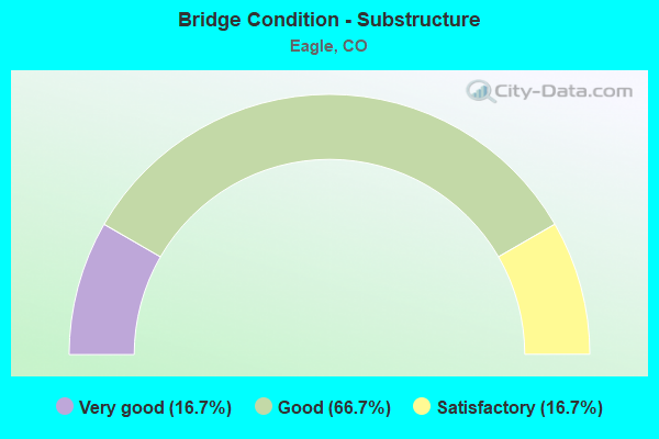
- Bridge Condition - Substructure
- 16.7%Very good
- 66.7%Good
- 16.7%Satisfactory

- Bridge Condition - Channel
- 75.0%Very good
- 16.7%Good
- 8.3%Satisfactory
Find on map >> Show street view
Structure Number: EAG-307-03.9A, Location: 4.3 MI S HWY 6 ON CR 307 (Lat: 39.623333, Lng: -106.775000), Route carried "on" structure: County highway , Year Built: 1988, Status: Open, Structure Length: 1.28m (4.20ft), Average Daily Traffic: 1,061 (year 2020), Truck Traffic: 3%, Average Future Daily Traffic: 1,316 (year 2040), Features Intersected: BRUSH CREEK, Facility Carried by Structure: BRUSH CREEK RD
Minimum Vertical Clearance: 30+ m (98+ ft), Kilometerpoint: 42.356, Lanes on structure: 2, Owner: County Highway Agency, Approaching Roadway Width: 8.4m (27.6ft), Material/Design: Prestressed concrete, Design/Construction: Tee Beam, Number Of Spans In Main Unit: 1, Length of Maximum Span: 12.0m (39.4ft), Curb-To-Curb Width: 9.6m (31.5ft), Out-to-Out Width: 10.3m (33.8ft)
Condition: Deck: Good, Superstructure: Good, Substructure: Good, Channel: Satisfactory, Operating Rating: 66.2 metric tons, Method Used To Determine Operating Rating: Load Factor (LF), Inventory Rating: 29.9 metric tons, Method Used To Determine Inventory Rating: Load Factor (LF), Structural Evaluation: Better than present minimum criteria, Deck Geometry: Somewhat better than minimum adequacy, Waterway Adequacy: Equal to present desirable criteria, Approach Roadway Alignment: Better than present minimum criteria, Designated Inspection Frequency: Every 24 months, Inspection Date: June 2020, Deck Structure Type: Concrete Precast Panels, Wearing Surface/Protective System: Wearing Surface: Bituminous
Find on map >> Show street view
Structure Number: EAG-307-06.1A, Location: 6.3 MILES FROM HWY 6 (Lat: 39.596667, Lng: -106.761944), Route carried "on" structure: County highway , Year Built: 1990, Status: Open, Structure Length: 1.42m (4.66ft), Average Daily Traffic: 778 (year 2020), Truck Traffic: 9%, Average Future Daily Traffic: 964 (year 2040), Features Intersected: BRUSH CREEK, Facility Carried by Structure: CO RD 307
Minimum Vertical Clearance: 30+ m (98+ ft), Kilometerpoint: 38.703, Lanes on structure: 2, Owner: County Highway Agency, Approaching Roadway Width: 7.3m (24.0ft), Skew: 3 degrees, Material/Design: Prestressed concrete, Design/Construction: Tee Beam, Number Of Spans In Main Unit: 1, Length of Maximum Span: 12.6m (41.3ft), Curb-To-Curb Width: 12.2m (40.0ft), Out-to-Out Width: 13.0m (42.7ft)
Condition: Deck: Good, Superstructure: Good, Substructure: Good, Channel: Good, Operating Rating: 59.1 metric tons, Method Used To Determine Operating Rating: Load Factor (LF), Inventory Rating: 35.6 metric tons, Method Used To Determine Inventory Rating: Load Factor (LF), Structural Evaluation: Better than present minimum criteria, Deck Geometry: Equal to present desirable criteria, Waterway Adequacy: Equal to present desirable criteria, Approach Roadway Alignment: Equal to present desirable criteria, Length Of Structure Improvement: 1.42m (4.66ft), Designated Inspection Frequency: Every 48 months, Inspection Date: June 2020, Deck Structure Type: Concrete Cast-file-Place, Wearing Surface/Protective System: Wearing Surface: Bituminous, Deck Protection: Epoxy Coated Reinforcing
Find on map >> Show street view
Structure Number: EAG-STP-00.2A, Location: 0.2 MI NW SH6 & SYLVA (Lat: 39.646944, Lng: -106.841667), Route carried "on" structure: County highway , Year Built: 2008, Status: Open, Structure Length: 1.58m (5.18ft), Average Daily Traffic: 177 (year 2020), Truck Traffic: 9%, Average Future Daily Traffic: 220 (year 2040), Design Load: HS 20, Features Intersected: BRUSH CREEK, Facility Carried by Structure: VIOLET LANE
Minimum Vertical Clearance: 30+ m (98+ ft), Kilometerpoint: 0.148, Lanes on structure: 2, Owner: County Highway Agency, Approaching Roadway Width: 6.4m (21.0ft), Material/Design: Steel, Design/Construction: Stringer/Multi-beam, Number Of Spans In Main Unit: 1, Length of Maximum Span: 14.6m (47.9ft), Curb-To-Curb Width: 6.7m (22.0ft), Out-to-Out Width: 6.7m (22.0ft)
Condition: Deck: Satisfactory, Superstructure: Satisfactory, Substructure: Good, Channel: Very good, Operating Rating: 46.3 metric tons, Method Used To Determine Operating Rating: Load Factor (LF), Inventory Rating: 27.7 metric tons, Method Used To Determine Inventory Rating: Load Factor (LF), Structural Evaluation: Equal to present minimum criteria, Deck Geometry: Meets minimum limits, Waterway Adequacy: Better than present minimum criteria, Approach Roadway Alignment: Equal to present desirable criteria, Designated Inspection Frequency: Every 24 months, Inspection Date: June 2020, Deck Structure Type: Corrugated Steel, Wearing Surface/Protective System: Wearing Surface: Bituminous
Find on map >> Show street view
Structure Number: EAGLE-CAPITOL, Location: .2 MI S BRUSH CREEK RD (Lat: 39.642778, Lng: -106.830000), Route carried "on" structure: City street , Year Built: 2001, Status: Open, Structure Length: 1.71m (5.61ft), Average Daily Traffic: 1,343 (year 2020), Truck Traffic: 2%, Average Future Daily Traffic: 1,665 (year 2040), Design Load: HS 25 or greater, Features Intersected: BRUSH CREEK, Facility Carried by Structure: CAPITOL STREET
Minimum Vertical Clearance: 30+ m (98+ ft), Kilometerpoint: 0.349, Lanes on structure: 2, Owner: Town or Township Highway Agency, Approaching Roadway Width: 6.9m (22.6ft), Material/Design: Prestressed concrete, Design/Construction: Box Beam or Girders - Single/Spread, Number Of Spans In Main Unit: 1, Length of Maximum Span: 15.3m (50.2ft), Curb-To-Curb Width: 7.9m (25.9ft), Out-to-Out Width: 8.5m (27.9ft)
Condition: Deck: Good, Superstructure: Good, Substructure: Good, Channel: Very good, Operating Rating: 43.2 metric tons, Method Used To Determine Operating Rating: Load Factor (LF), Inventory Rating: 25.9 metric tons, Method Used To Determine Inventory Rating: Load Factor (LF), Structural Evaluation: Equal to present minimum criteria, Deck Geometry: Meets minimum limits, Waterway Adequacy: Equal to present desirable criteria, Approach Roadway Alignment: Better than present minimum criteria, Length Of Structure Improvement: 1.71m (5.61ft), Designated Inspection Frequency: Every 24 months, Inspection Date: June 2020, Bridge Improvement Cost: $288,000, Roadway Improvement Cost: $29,000, Total Project Cost: $317,000 ( Estimate for 2014), Deck Structure Type: Concrete Cast-file-Place, Wearing Surface/Protective System: Wearing Surface: Bituminous, Membrane: Built-up, Deck Protection: Epoxy Coated Reinforcing
Find on map >> Show street view
Structure Number: EAGLE-HAYSTACK, Location: 2 MI E OF EAGLE RANCH RD (Lat: 39.618922, Lng: -106.792461), Route carried "on" structure: City street , Year Built: 2014, Status: Open, Structure Length: 3.12m (10.24ft), Average Daily Traffic: 56 (year 2020), Truck Traffic: 1%, Average Future Daily Traffic: 70 (year 2040), Features Intersected: MAYERS GULCH, Facility Carried by Structure: HAYSTACK DRIVE
Minimum Vertical Clearance: 30.45m (99.90ft), Kilometerpoint: 3.650, Lanes on structure: 2, Owner: Town or Township Highway Agency, Approaching Roadway Width: 7.6m (24.9ft), Material/Design: Prestressed concrete, Design/Construction: Stringer/Multi-beam, Number Of Spans In Main Unit: 1, Length of Maximum Span: 29.7m (97.4ft), Curb-To-Curb Width: 9.1m (29.9ft), Out-to-Out Width: 10.1m (33.1ft)
Condition: Deck: Good, Superstructure: Good, Substructure: Good, Channel: Very good, Operating Rating: 72.6 metric tons, Method Used To Determine Operating Rating: Load and Resistance Factor (LRFR), Inventory Rating: 49.0 metric tons, Method Used To Determine Inventory Rating: Load and Resistance Factor (LRFR), Structural Evaluation: Better than present minimum criteria, Deck Geometry: Better than present minimum criteria, Waterway Adequacy: Equal to present desirable criteria, Approach Roadway Alignment: Equal to present desirable criteria, Designated Inspection Frequency: Every 24 months, Inspection Date: June 2020, Deck Structure Type: Concrete Cast-file-Place, Wearing Surface/Protective System: Wearing Surface: Bituminous, Membrane: Built-up, Deck Protection: Epoxy Coated Reinforcing
Find on map >> Show street view
Structure Number: EAGLE-OUZEL, Location: W OF BRUSH CREEK RD (Lat: 39.633333, Lng: -106.802500), Route carried "on" structure: City street , Year Built: 2002, Status: Open, Structure Length: 1.68m (5.51ft), Average Daily Traffic: 601 (year 2020), Truck Traffic: 1%, Average Future Daily Traffic: 745 (year 2040), Design Load: HS 25 or greater, Features Intersected: BRUSH CREEK, Facility Carried by Structure: OUZEL LANE
Minimum Vertical Clearance: 30+ m (98+ ft), Kilometerpoint: 0.129, Lanes on structure: 2, Owner: Town or Township Highway Agency, Approaching Roadway Width: 8.5m (27.9ft), Material/Design: Prestressed concrete, Design/Construction: Box Beam or Girders - Multiple, Number Of Spans In Main Unit: 1, Length of Maximum Span: 15.2m (49.9ft), Curb or Sidewalk Widths: Left: 3.0m (9.8ft), Right: 0.0m, Curb-To-Curb Width: 8.5m (27.9ft), Out-to-Out Width: 12.4m (40.7ft)
Condition: Deck: Good, Superstructure: Good, Substructure: Good, Channel: Very good, Operating Rating: 68.0 metric tons, Method Used To Determine Operating Rating: Load Factor (LF), Inventory Rating: 38.6 metric tons, Method Used To Determine Inventory Rating: Load Factor (LF), Structural Evaluation: Better than present minimum criteria, Deck Geometry: Somewhat better than minimum adequacy, Waterway Adequacy: Equal to present desirable criteria, Approach Roadway Alignment: Equal to present desirable criteria, Designated Inspection Frequency: Every 24 months, Inspection Date: June 2020, Deck Structure Type: Other, Wearing Surface/Protective System: Wearing Surface: Bituminous, Membrane: Built-up, Deck Protection: Epoxy Coated Reinforcing
Find on map >> Show street view
Structure Number: EAGLE-SYLVAN-1, Location: JUST SOUTH OF US6 (Lat: 39.646389, Lng: -106.837778), Route carried "on" structure: City street , Year Built: 2001, Status: Open, Structure Length: 2.07m (6.79ft), Average Daily Traffic: 6,966 (year 2020), Truck Traffic: 3%, Average Future Daily Traffic: 8,638 (year 2040), Design Load: HS 25 or greater, Features Intersected: BRUSH CREEK, Facility Carried by Structure: SYLVAN LAKE RD
Minimum Vertical Clearance: 30+ m (98+ ft), Kilometerpoint: 0.153, Lanes on structure: 2, Owner: Town or Township Highway Agency, Approaching Roadway Width: 10.3m (33.8ft), Material/Design: Prestressed concrete, Design/Construction: Stringer/Multi-beam, Number Of Spans In Main Unit: 1, Length of Maximum Span: 18.9m (62.0ft), Curb or Sidewalk Widths: Left: 0.0m, Right: 2.7m (8.9ft), Curb-To-Curb Width: 9.8m (32.2ft), Out-to-Out Width: 13.4m (44.0ft)
Condition: Deck: Good, Superstructure: Good, Substructure: Good, Channel: Very good, Operating Rating: 51.7 metric tons, Method Used To Determine Operating Rating: Load Factor (LF), Inventory Rating: 30.9 metric tons, Method Used To Determine Inventory Rating: Load Factor (LF), Structural Evaluation: Better than present minimum criteria, Deck Geometry: Meets minimum limits, Waterway Adequacy: Equal to present desirable criteria, Approach Roadway Alignment: Better than present minimum criteria, Designated Inspection Frequency: Every 24 months, Inspection Date: June 2020, Deck Structure Type: Concrete Cast-file-Place, Wearing Surface/Protective System: Wearing Surface: Bituminous, Membrane: Built-up, Deck Protection: Epoxy Coated Reinforcing
Find on map >> Show street view
Structure Number: EAGLE-SYLVAN-2, Location: JUST WEST OF LIME PARK DR (Lat: 39.636667, Lng: -106.824167), Route carried "on" structure: City street , Year Built: 2001, Status: Open, Structure Length: 0.69m (2.26ft), Average Daily Traffic: 1,796 (year 2020), Truck Traffic: 2%, Average Future Daily Traffic: 2,227 (year 2040), Design Load: HS 25 or greater, Features Intersected: ABRAMS CREEK, Facility Carried by Structure: SYLVAN LAKE ROAD
Minimum Vertical Clearance: 30+ m (98+ ft), Kilometerpoint: 1.941, Lanes on structure: 2, Owner: Town or Township Highway Agency, Approaching Roadway Width: 9.4m (30.8ft), Skew: 1 degrees, Material/Design: Concrete, Design/Construction: Culvert, Number Of Spans In Main Unit: 1, Length of Maximum Span: 6.9m (22.6ft), Curb or Sidewalk Widths: Left: 3.3m (10.8ft), Right: 0.0m, Curb-To-Curb Width: 9.8m (32.2ft), Out-to-Out Width: 14.5m (47.6ft)
Condition: Channel: Very good, Culverts: Good, Operating Rating: 81.6 metric tons, Method Used To Determine Operating Rating: Load Factor (LF), Inventory Rating: 73.7 metric tons, Method Used To Determine Inventory Rating: Load Factor (LF), Structural Evaluation: Better than present minimum criteria, Deck Geometry: Somewhat better than minimum adequacy, Waterway Adequacy: Equal to present desirable criteria, Approach Roadway Alignment: Better than present minimum criteria, Designated Inspection Frequency: Every 24 months, Inspection Date: June 2020
Find on map >> Show street view
Structure Number: EAGLE-SYLVAN-3, Location: 0.1 MI S OF BRUSH CRK RD (Lat: 39.637778, Lng: -106.818056), Route carried "on" structure: City street , Year Built: 2007, Status: Open, Structure Length: 1.81m (5.94ft), Average Daily Traffic: 1,343 (year 2020), Truck Traffic: 2%, Average Future Daily Traffic: 1,665 (year 2040), Design Load: HL 93, Features Intersected: BRUSH CREEK, Facility Carried by Structure: SYLVAN LAKE RD
Minimum Vertical Clearance: 30+ m (98+ ft), Kilometerpoint: 2.551, Lanes on structure: 2, Owner: Town or Township Highway Agency, Approaching Roadway Width: 9.7m (31.8ft), Skew: 2 degrees, Material/Design: Prestressed concrete, Design/Construction: Box Beam or Girders - Multiple, Number Of Spans In Main Unit: 1, Length of Maximum Span: 16.9m (55.4ft), Curb or Sidewalk Widths: Left: 3.0m (9.8ft), Right: 0.0m, Curb-To-Curb Width: 9.9m (32.5ft), Out-to-Out Width: 14.4m (47.2ft)
Condition: Deck: Good, Superstructure: Good, Substructure: Good, Channel: Good, Operating Rating: 46.7 metric tons, Method Used To Determine Operating Rating: Load and Resistance Factor Rating (LRFR) rating reported by rating factor(RF) method using HL-93 loadings, Inventory Rating: 36.0 metric tons, Method Used To Determine Inventory Rating: Load and Resistance Factor Rating (LRFR) rating reported by rating factor(RF) method using HL-93 loadings, Structural Evaluation: Better than present minimum criteria, Deck Geometry: Somewhat better than minimum adequacy, Waterway Adequacy: Better than present minimum criteria, Approach Roadway Alignment: Equal to present desirable criteria, Designated Inspection Frequency: Every 24 months, Inspection Date: June 2020, Deck Structure Type: Other, Wearing Surface/Protective System: Wearing Surface: Bituminous, Membrane: Preformed Fabric
Find on map >> Show street view
Structure Number: F-09-AB, Location: EAGLE INTERCHANGE (Lat: 39.659908, Lng: -106.827369), Route carried "on" structure: Spur State highway 70F, Year Built: 1972, Year Reconstructed: 1986, Status: Open, Structure Length: 6.57m (21.56ft), Average Daily Traffic: 19,000 (year 2020), Truck Traffic: 5%, Average Future Daily Traffic: 25,080 (year 2040), Design Load: HS 20+Mod, Features Intersected: I 70A ML
Minimum Vertical Clearance: 30+ m (98+ ft), Kilometerpoint: 0.478, Lanes on structure: 3, Lanes under structure: 4, Owner: State Highway Agency, Approaching Roadway Width: 14.6m (47.9ft), Material/Design: Concrete continuous, Design/Construction: Box Beam or Girders - Single/Spread, Number Of Spans In Main Unit: 2, Length of Maximum Span: 33.8m (110.9ft), Curb-To-Curb Width: 14.6m (47.9ft), Out-to-Out Width: 15.4m (50.5ft)
Condition: Deck: Fair, Superstructure: Satisfactory, Substructure: Satisfactory, Operating Rating: 79.8 metric tons, Method Used To Determine Operating Rating: Load Factor (LF), Inventory Rating: 44.5 metric tons, Method Used To Determine Inventory Rating: Load Factor (LF), Structural Evaluation: Equal to present minimum criteria, Deck Geometry: Somewhat better than minimum adequacy, Underclear: Better than present minimum criteria, Approach Roadway Alignment: Equal to present desirable criteria, Designated Inspection Frequency: Every 24 months, Inspection Date: July 2020, Deck Structure Type: Concrete Cast-file-Place, Wearing Surface/Protective System: Wearing Surface: Monolithic Concrete, Membrane: Preformed Fabric
Find on map >> Show street view
Structure Number: F-09-AS, Location: 0.7 MI E OF EAGLE (Lat: 39.660042, Lng: -106.815789), Route carried "on" structure: US 6E, Year Built: 2012, Status: Open, Structure Length: 4.13m (13.55ft), Average Daily Traffic: 3,400 (year 2020), Truck Traffic: 4%, Average Future Daily Traffic: 5,066 (year 2040), Design Load: HL 93, Features Intersected: EAGLE RIVER, Facility Carried by Structure: US 6 ML
Minimum Vertical Clearance: 30+ m (98+ ft), Kilometerpoint: 0.840, Lanes on structure: 2, Owner: State Highway Agency, Approaching Roadway Width: 17.1m (56.1ft), Skew: 2 degrees, Material/Design: Prestressed concrete, Design/Construction: Stringer/Multi-beam, Number Of Spans In Main Unit: 1, Length of Maximum Span: 40.5m (132.9ft), Curb-To-Curb Width: 17.1m (56.1ft), Out-to-Out Width: 18.0m (59.1ft)
Condition: Deck: Good, Superstructure: Very good, Substructure: Very good, Channel: Very good, Operating Rating: 55.1 metric tons, Method Used To Determine Operating Rating: Load and Resistance Factor Rating (LRFR) rating reported by rating factor(RF) method using HL-93 loadings, Inventory Rating: 42.1 metric tons, Method Used To Determine Inventory Rating: Load and Resistance Factor Rating (LRFR) rating reported by rating factor(RF) method using HL-93 loadings, Structural Evaluation: Equal to present desirable criteria, Deck Geometry: Superior to present desirable criteria, Waterway Adequacy: Equal to present desirable criteria, Approach Roadway Alignment: Equal to present desirable criteria, Designated Inspection Frequency: Every 24 months, Inspection Date: August 2020, Deck Structure Type: Concrete Precast Panels, Wearing Surface/Protective System: Wearing Surface: Bituminous, Membrane: Built-up
Find on map >> Show street view
Structure Number: F-09-AU, Location: 0.2 MI W of SYLVAN LK RD (Lat: 39.646417, Lng: -106.841267), Route carried "on" structure: City street , Year Built: 2014, Status: Open, Structure Length: 3.73m (12.24ft), Average Daily Traffic: 12,590 (year 2020), Truck Traffic: 5%, Average Future Daily Traffic: 15,612 (year 2040), Design Load: HL 93, Features Intersected: BRUSH CREEK, Facility Carried by Structure: PREV. US 6 ML
Minimum Vertical Clearance: 30+ m (98+ ft), Kilometerpoint: 1.371, Lanes on structure: 2, Owner: Town or Township Highway Agency, Approaching Roadway Width: 13.1m (43.0ft), Material/Design: Prestressed concrete, Design/Construction: Stringer/Multi-beam, Number Of Spans In Main Unit: 1, Length of Maximum Span: 35.8m (117.5ft), Curb-To-Curb Width: 12.2m (40.0ft), Out-to-Out Width: 13.1m (43.0ft)
Condition: Deck: Good, Superstructure: Very good, Substructure: Very good, Channel: Very good, Operating Rating: 58.3 metric tons, Method Used To Determine Operating Rating: Load and Resistance Factor Rating (LRFR) rating reported by rating factor(RF) method using HL-93 loadings, Inventory Rating: 35.6 metric tons, Method Used To Determine Inventory Rating: Load and Resistance Factor Rating (LRFR) rating reported by rating factor(RF) method using HL-93 loadings, Structural Evaluation: Equal to present desirable criteria, Deck Geometry: Somewhat better than minimum adequacy, Waterway Adequacy: Equal to present desirable criteria, Approach Roadway Alignment: Equal to present desirable criteria, Designated Inspection Frequency: Every 24 months, Inspection Date: June 2020, Deck Structure Type: Concrete Cast-file-Place, Wearing Surface/Protective System: Wearing Surface: Bituminous, Membrane: Built-up, Deck Protection: Epoxy Coated Reinforcing
Find on map >> Show street view
Structure Number: F-09-Z, Location: EAGLE EBY CRK RD (Lat: 39.656972, Lng: -106.825414), Route carried "on" structure: Spur State highway 70F, Year Built: 1972, Status: Open, Structure Length: 3.78m (12.40ft), Average Daily Traffic: 19,000 (year 2020), Truck Traffic: 5%, Average Future Daily Traffic: 25,080 (year 2040), Design Load: HL 93, Features Intersected: EAGLE RIVER, Facility Carried by Structure: I 70 EAGLE SPUR
Minimum Vertical Clearance: 30+ m (98+ ft), Kilometerpoint: 0.108, Lanes on structure: 4, Owner: State Highway Agency, Approaching Roadway Width: 16.5m (54.1ft), Material/Design: Steel, Design/Construction: Stringer/Multi-beam, Number Of Spans In Main Unit: 1, Length of Maximum Span: 36.6m (120.1ft), Curb-To-Curb Width: 16.5m (54.1ft), Out-to-Out Width: 17.3m (56.8ft)
Condition: Deck: Satisfactory, Superstructure: Satisfactory, Substructure: Satisfactory, Channel: Very good, Operating Rating: 38.9 metric tons, Method Used To Determine Operating Rating: Load and Resistance Factor Rating (LRFR) rating reported by rating factor(RF) method using HL-93 loadings, Inventory Rating: 29.2 metric tons, Method Used To Determine Inventory Rating: Load and Resistance Factor Rating (LRFR) rating reported by rating factor(RF) method using HL-93 loadings, Structural Evaluation: Equal to present minimum criteria, Deck Geometry: Meets minimum limits, Waterway Adequacy: Equal to present desirable criteria, Approach Roadway Alignment: Equal to present desirable criteria, Designated Inspection Frequency: Every 24 months, Inspection Date: July 2020, Deck Structure Type: Concrete Cast-file-Place, Wearing Surface/Protective System: Wearing Surface: Bituminous, Membrane: Preformed Fabric
Find on map >> Show street view
Structure Number: F-09-AB, Location: EAGLE INTERCHANGE (Lat: 39.659908, Lng: -106.827369), Route carried "under" structure: Interstate 70A, Year Built: 1972, Structure Length: 0. m, Average Daily Traffic: 17,000 (year 2011), Truck Traffic: 16%, Features Intersected: I 70A ML, Facility Carried by Structure: I 70F SPUR
Minimum Vertical Clearance: 5.51m (18.08ft), Kilometerpoint: 235.957, Lanes on structure: 3, Lanes under structure: 4, Material/Design: Concrete continuous, Design/Construction: Box Beam or Girders - Single/Spread, Length of Maximum Span: 33.8m (110.9ft)