Bridge Statistics for Dushore, Pennsylvania (PA)
Condition, Traffic, Stress, Structural Evaluation, Project Costs
- National Bridge Inventory (NBI) Statistics
- 25Number of bridges
- 98ft / 30.0mTotal length
- $2,265,000Total costs
- 26,311Total average daily traffic
- 4,037Total average daily truck traffic
- 35,849Total future (year 2032) average daily traffic
- National Bridge Inventory (NBI) Registered Bridges for Dushore
- No street view available for this location
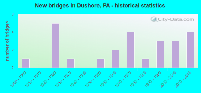
- New bridges - historical statistics
- 11900-1909
- 51920-1929
- 11930-1939
- 11950-1959
- 21960-1969
- 41970-1979
- 11980-1989
- 31990-1999
- 32000-2009
- 42010-2019

- Reconstructed bridges - Historical Statistics
- 21990-1999
- 22000-2009
- 32010-2019


- Bridge Condition - Deck
- 14.3%Excellent
- 33.3%Very good
- 28.6%Good
- 9.5%Satisfactory
- 9.5%Fair
- 4.8%Poor

- Bridge Condition - Superstructure
- 14.3%Excellent
- 23.8%Very good
- 23.8%Good
- 9.5%Satisfactory
- 19.0%Fair
- 4.8%Poor
- 4.8%Imminent failure

- Bridge Condition - Substructure
- 9.5%Very good
- 42.9%Good
- 19.0%Satisfactory
- 28.6%Fair

- Bridge Condition - Channel
- 24.0%Very good
- 28.0%Good
- 12.0%Satisfactory
- 32.0%Fair
- 4.0%Poor

- Bridge Condition - Culverts
- 25.0%Very good
- 50.0%Good
- 25.0%Satisfactory
Find on map >> Show street view
Structure Number: 6372, Location: 2 MILE EAST OF LADDSBURG (Lat: 41.567675, Lng: -76.393872), Route carried "on" structure: State highway , Year Built: 1971, Year Reconstructed: 2004, Status: Open, Structure Length: 0.73m (2.40ft), Average Daily Traffic: 473 (year 2022), Truck Traffic: 8%, Average Future Daily Traffic: 453 (year 2032), Features Intersected: BOWMAN CREEK, Facility Carried by Structure: SR 2011
Minimum Vertical Clearance: 30+ m (98+ ft), Kilometerpoint: 0.000, Lanes on structure: 2, Owner: State Highway Agency, Approaching Roadway Width: 6.4m (21.0ft), Material/Design: Concrete, Design/Construction: Channel Beam, Number Of Spans In Main Unit: 1, Length of Maximum Span: 6.7m (22.0ft), Curb or Sidewalk Widths: Left: 0.2m (0.7ft), Right: 0.2m (0.7ft), Curb-To-Curb Width: 7.8m (25.6ft), Out-to-Out Width: 8.4m (27.6ft)
Condition: Deck: Very good, Superstructure: Good, Substructure: Fair, Channel: Poor, Inventory Rating: 99.8 metric tons, Method Used To Determine Inventory Rating: Load Factor (LF), Structural Evaluation: Somewhat better than minimum adequacy, Deck Geometry: Meets minimum limits, Waterway Adequacy: Better than present minimum criteria, Approach Roadway Alignment: Equal to present desirable criteria, Length Of Structure Improvement: 0.70m (2.30ft), Designated Inspection Frequency: Every 24 months, Inspection Date: September 2021, Wearing Surface/Protective System: Wearing Surface: Bituminous, Membrane: Preformed Fabric
Find on map >> Show street view
Structure Number: 6557, Location: EAST INT. SR. 2008 (Lat: 41.559600, Lng: -76.380886), Route carried "on" structure: City street , Year Built: 2015, Status: Open, Structure Length: 1.13m (3.71ft), Average Daily Traffic: 100 (year 2021), Truck Traffic: 4%, Average Future Daily Traffic: 155 (year 2043), Design Load: HL 93, Features Intersected: SOUTH BOWMAN CREEK, Facility Carried by Structure: T-377 (BR. # 1)
Minimum Vertical Clearance: 30+ m (98+ ft), Kilometerpoint: 0.000, Lanes on structure: 2, Owner: Town or Township Highway Agency, Approaching Roadway Width: 4.3m (14.1ft), Material/Design: Steel, Design/Construction: Stringer/Multi-beam, Number Of Spans In Main Unit: 1, Length of Maximum Span: 10.7m (35.1ft), Curb-To-Curb Width: 5.5m (18.0ft), Out-to-Out Width: 6.6m (21.7ft)
Condition: Deck: Very good, Superstructure: Very good, Substructure: Very good, Channel: Fair, Operating Rating: 44.1 metric tons, Method Used To Determine Operating Rating: Assigned ratings based on Load and Resistance Factor Design (LRFD) reported by rating factor (RF) using HL93 loadings, Inventory Rating: 34.0 metric tons, Method Used To Determine Inventory Rating: Assigned ratings based on Load and Resistance Factor Design (LRFD) reported by rating factor (RF) using HL93 loadings, Structural Evaluation: Equal to present desirable criteria, Deck Geometry: Meets minimum limits, Waterway Adequacy: Better than present minimum criteria, Approach Roadway Alignment: Equal to present minimum criteria, Length Of Structure Improvement: 1.00m (3.28ft), Designated Inspection Frequency: Every 24 months, Inspection Date: July 2021, Bridge Improvement Cost: $17,000, Roadway Improvement Cost: $35,000, Total Project Cost: $355,000, Deck Structure Type: Concrete Cast-file-Place, Wearing Surface/Protective System: Wearing Surface: Monolithic Concrete, Deck Protection: Epoxy Coated Reinforcing
Find on map >> Show street view
Structure Number: 656, Location: 2.4 MI. SE OF LADDSBURG (Lat: 41.561639, Lng: -76.375303), Route carried "on" structure: City street , Year Built: 1972, Year Reconstructed: 2015, Status: Open, Structure Length: 0.79m (2.59ft), Average Daily Traffic: 50 (year 2021), Truck Traffic: 6%, Average Future Daily Traffic: 77 (year 2043), Design Load: HL 93, Features Intersected: BOWMAN CREEK, Facility Carried by Structure: T-410
Minimum Vertical Clearance: 30+ m (98+ ft), Kilometerpoint: 0.000, Lanes on structure: 1, Owner: Town or Township Highway Agency, Approaching Roadway Width: 4.9m (16.1ft), Skew: 4 degrees, Material/Design: Steel, Design/Construction: Stringer/Multi-beam, Number Of Spans In Main Unit: 1, Length of Maximum Span: 7.3m (24.0ft), Curb-To-Curb Width: 4.5m (14.8ft), Out-to-Out Width: 5.6m (18.4ft)
Condition: Deck: Very good, Superstructure: Excellent, Substructure: Satisfactory, Channel: Fair, Operating Rating: 49.6 metric tons, Method Used To Determine Operating Rating: Assigned ratings based on Load and Resistance Factor Design (LRFD) reported by rating factor (RF) using HL93 loadings, Inventory Rating: 38.2 metric tons, Method Used To Determine Inventory Rating: Assigned ratings based on Load and Resistance Factor Design (LRFD) reported by rating factor (RF) using HL93 loadings, Structural Evaluation: Equal to present minimum criteria, Deck Geometry: Equal to present minimum criteria, Waterway Adequacy: Equal to present desirable criteria, Approach Roadway Alignment: Equal to present desirable criteria, Length Of Structure Improvement: 0.80m (2.62ft), Designated Inspection Frequency: Every 24 months, Inspection Date: July 2021, Bridge Improvement Cost: $14,000, Roadway Improvement Cost: $29,000, Total Project Cost: $298,000, Deck Structure Type: Concrete Cast-file-Place, Wearing Surface/Protective System: Wearing Surface: Monolithic Concrete, Deck Protection: Epoxy Coated Reinforcing
Find on map >> Show street view
Structure Number: 29511, Location: NEAR LEBO (Lat: 40.308644, Lng: -77.279656), Route carried "on" structure: State highway 74, Year Built: 1923, Status: Open, Structure Length: 0.85m (2.79ft), Average Daily Traffic: 2,172 (year 2022), Truck Traffic: 12%, Average Future Daily Traffic: 2,987 (year 2032), Features Intersected: GREEN VALLEY RUN
Minimum Vertical Clearance: 30+ m (98+ ft), Kilometerpoint: 4.836, Lanes on structure: 2, Owner: State Highway Agency, Approaching Roadway Width: 7.9m (25.9ft), Material/Design: Concrete, Design/Construction: Tee Beam, Number Of Spans In Main Unit: 1, Length of Maximum Span: 7.3m (24.0ft), Curb or Sidewalk Widths: Left: 0.1m (0.3ft), Right: 0.1m (0.3ft), Curb-To-Curb Width: 7.1m (23.3ft), Out-to-Out Width: 8.0m (26.2ft)
Condition: Deck: Satisfactory, Superstructure: Fair, Substructure: Fair, Channel: Satisfactory, Operating Rating: 49.0 metric tons, Method Used To Determine Operating Rating: Field evaluation and documented engineering judgment, Inventory Rating: 32.7 metric tons, Method Used To Determine Inventory Rating: Field evaluation and documented engineering judgment, Structural Evaluation: Somewhat better than minimum adequacy, Deck Geometry: High priority of replacement, Waterway Adequacy: Somewhat better than minimum adequacy, Approach Roadway Alignment: Equal to present minimum criteria, Length Of Structure Improvement: 1.50m (4.92ft), Designated Inspection Frequency: Every 24 months, Inspection Date: December 2020, Bridge Improvement Cost: $8,000, Roadway Improvement Cost: $22,000, Total Project Cost: $103,000, Deck Structure Type: Concrete Cast-file-Place, Wearing Surface/Protective System: Wearing Surface: Bituminous
Find on map >> Show street view
Structure Number: 31965, Location: 3.5 MI SW OF DUSHORE (Lat: 41.518689, Lng: -76.435331), Route carried "on" structure: State highway 87, Year Built: 1993, Status: Open, Structure Length: 0.70m (2.30ft), Average Daily Traffic: 1,026 (year 2022), Truck Traffic: 22%, Average Future Daily Traffic: 2,042 (year 2032), Design Load: HS 25 or greater, Features Intersected: TRIB.LITTLE LOYALSOCK CK
Minimum Vertical Clearance: 30+ m (98+ ft), Kilometerpoint: 36.117, Lanes on structure: 2, Base Highway Network: Yes, Owner: State Highway Agency, Approaching Roadway Width: 7.9m (25.9ft), Skew: 4 degrees, Material/Design: Concrete, Design/Construction: Culvert, Number Of Spans In Main Unit: 1, Length of Maximum Span: 7.0m (23.0ft), Curb-To-Curb Width: 11.0m (36.1ft), Out-to-Out Width: 11.9m (39.0ft)
Condition: Channel: Very good, Culverts: Good, Operating Rating: 96.2 metric tons, Method Used To Determine Operating Rating: Load Factor (LF), Inventory Rating: 57.2 metric tons, Method Used To Determine Inventory Rating: Load Factor (LF), Structural Evaluation: Better than present minimum criteria, Deck Geometry: Equal to present minimum criteria, Waterway Adequacy: Superior to present desirable criteria, Approach Roadway Alignment: Equal to present desirable criteria, Length Of Structure Improvement: 0.70m (2.30ft), Designated Inspection Frequency: Every 48 months, Inspection Date: November 2018
Find on map >> Show street view
Structure Number: 31967, Location: BORO OF DUSHORE (Lat: 41.523722, Lng: -76.400583), Route carried "on" structure: State highway 87, Year Built: 1967, Status: Open, Structure Length: 0.85m (2.79ft), Average Daily Traffic: 3,041 (year 2022), Truck Traffic: 13%, Average Future Daily Traffic: 5,349 (year 2032), Design Load: HS 20, Features Intersected: LITTLE LOYALSOCK CREEK
Minimum Vertical Clearance: 30+ m (98+ ft), Kilometerpoint: 38.782, Lanes on structure: 2, Base Highway Network: Yes, Owner: State Highway Agency, Approaching Roadway Width: 12.5m (41.0ft), Skew: 3 degrees, Material/Design: Concrete, Design/Construction: Culvert, Number Of Spans In Main Unit: 1, Length of Maximum Span: 8.5m (27.9ft), Curb or Sidewalk Widths: Left: 1.5m (4.9ft), Right: 0.0m, Curb-To-Curb Width: 27.2m (89.2ft), Out-to-Out Width: 29.1m (95.5ft)
Condition: Channel: Good, Culverts: Satisfactory, Operating Rating: 54.4 metric tons, Method Used To Determine Operating Rating: Field evaluation and documented engineering judgment, Inventory Rating: 32.7 metric tons, Method Used To Determine Inventory Rating: Field evaluation and documented engineering judgment, Structural Evaluation: Equal to present minimum criteria, Deck Geometry: Superior to present desirable criteria, Waterway Adequacy: Superior to present desirable criteria, Approach Roadway Alignment: Equal to present desirable criteria, Length Of Structure Improvement: 0.90m (2.95ft), Designated Inspection Frequency: Every 24 months, Inspection Date: November 2020
Find on map >> Show street view
Structure Number: 32002, Location: BOROUGH OF DUSHORE (Lat: 41.525722, Lng: -76.400475), Route carried "on" structure: US 220, Year Built: 1925, Status: Open, Structure Length: 0.91m (2.99ft), Average Daily Traffic: 3,098 (year 2022), Truck Traffic: 21%, Average Future Daily Traffic: 4,737 (year 2032), Features Intersected: OVER MARSH CREEK
Minimum Vertical Clearance: 30+ m (98+ ft), Kilometerpoint: 33.600, Lanes on structure: 2, Base Highway Network: Yes, Owner: State Highway Agency, Approaching Roadway Width: 9.1m (29.9ft), Skew: 3 degrees, Material/Design: Concrete, Design/Construction: Tee Beam, Number Of Spans In Main Unit: 1, Length of Maximum Span: 8.5m (27.9ft), Curb-To-Curb Width: 9.4m (30.8ft), Out-to-Out Width: 10.4m (34.1ft)
Condition: Deck: Fair, Superstructure: Fair, Substructure: Fair, Channel: Good, Operating Rating: 58.1 metric tons, Method Used To Determine Operating Rating: Load Factor (LF), Inventory Rating: 34.5 metric tons, Method Used To Determine Inventory Rating: Load Factor (LF), Structural Evaluation: Somewhat better than minimum adequacy, Deck Geometry: Meets minimum limits, Waterway Adequacy: Equal to present minimum criteria, Approach Roadway Alignment: Equal to present desirable criteria, Length Of Structure Improvement: 0.90m (2.95ft), Designated Inspection Frequency: Every 24 months, Inspection Date: November 2020, Bridge Improvement Cost: $26,000, Roadway Improvement Cost: $76,000, Total Project Cost: $348,000, Deck Structure Type: Concrete Cast-file-Place, Wearing Surface/Protective System: Wearing Surface: Bituminous, Membrane: Preformed Fabric
Find on map >> Show street view
Structure Number: 32022, Location: EAST OF DUSHORE (Lat: 41.527719, Lng: -76.375228), Route carried "on" structure: State highway , Year Built: 1953, Year Reconstructed: 1996, Status: Open, Structure Length: 0.82m (2.69ft), Average Daily Traffic: 436 (year 2022), Truck Traffic: 24%, Average Future Daily Traffic: 427 (year 2032), Features Intersected: LITTLE LOYALSOCK CREEK, Facility Carried by Structure: SR 1012
Minimum Vertical Clearance: 30+ m (98+ ft), Kilometerpoint: 0.607, Lanes on structure: 2, Owner: State Highway Agency, Approaching Roadway Width: 5.5m (18.0ft), Material/Design: Steel, Design/Construction: Stringer/Multi-beam, Number Of Spans In Main Unit: 1, Length of Maximum Span: 7.6m (24.9ft), Curb or Sidewalk Widths: Left: 0.2m (0.7ft), Right: 0.2m (0.7ft), Curb-To-Curb Width: 7.3m (24.0ft), Out-to-Out Width: 8.2m (26.9ft)
Condition: Deck: Very good, Superstructure: Good, Substructure: Good, Channel: Fair, Operating Rating: 78.0 metric tons, Method Used To Determine Operating Rating: Load Factor (LF), Inventory Rating: 46.3 metric tons, Method Used To Determine Inventory Rating: Load Factor (LF), Structural Evaluation: Better than present minimum criteria, Deck Geometry: Meets minimum limits, Waterway Adequacy: Superior to present desirable criteria, Approach Roadway Alignment: Equal to present desirable criteria, Length Of Structure Improvement: 0.80m (2.62ft), Designated Inspection Frequency: Every 48 months, Inspection Date: November 2018, Bridge Improvement Cost: $15,000, Roadway Improvement Cost: $43,000, Total Project Cost: $198,000, Deck Structure Type: Concrete Cast-file-Place, Wearing Surface/Protective System: Wearing Surface: Epoxy Overlay, Deck Protection: Epoxy Coated Reinforcing
Find on map >> Show street view
Structure Number: 32075, Location: 3.5 MI.NW. OF DUSHORE (Lat: 41.534653, Lng: -76.448461), Route carried "on" structure: State highway , Year Built: 1985, Year Reconstructed: 2011, Status: Open, Structure Length: 1.10m (3.61ft), Average Daily Traffic: 305 (year 2020), Truck Traffic: 10%, Average Future Daily Traffic: 720 (year 2032), Design Load: HS 20+Mod, Features Intersected: OVER LICK CREEK, Facility Carried by Structure: SR 4018
Minimum Vertical Clearance: 30+ m (98+ ft), Kilometerpoint: 7.532, Lanes on structure: 2, Owner: State Highway Agency, Approaching Roadway Width: 6.1m (20.0ft), Skew: 3 degrees, Material/Design: Prestressed concrete, Design/Construction: Box Beam or Girders - Multiple, Number Of Spans In Main Unit: 1, Length of Maximum Span: 10.7m (35.1ft), Curb or Sidewalk Widths: Left: 0.2m (0.7ft), Right: 0.2m (0.7ft), Curb-To-Curb Width: 8.2m (26.9ft), Out-to-Out Width: 9.3m (30.5ft)
Condition: Deck: Very good, Superstructure: Good, Substructure: Good, Channel: Good, Inventory Rating: 56.2 metric tons, Method Used To Determine Inventory Rating: Load Factor (LF), Structural Evaluation: Better than present minimum criteria, Deck Geometry: Somewhat better than minimum adequacy, Waterway Adequacy: Better than present minimum criteria, Approach Roadway Alignment: Equal to present desirable criteria, Length Of Structure Improvement: 1.10m (3.61ft), Designated Inspection Frequency: Every 48 months, Inspection Date: November 2018, Wearing Surface/Protective System: Wearing Surface: Epoxy Overlay, Deck Protection: Epoxy Coated Reinforcing
Find on map >> Show street view
Structure Number: 32076, Location: BORO OF DUSHORE (Lat: 41.524658, Lng: -76.402178), Route carried "on" structure: State highway , Year Built: 1964, Year Reconstructed: 2008, Status: Open, Structure Length: 0.82m (2.69ft), Average Daily Traffic: 3,886 (year 2022), Truck Traffic: 7%, Average Future Daily Traffic: 2,821 (year 2032), Design Load: HS 20, Features Intersected: OVER MARSH RUN, Facility Carried by Structure: SR 4018
Minimum Vertical Clearance: 30+ m (98+ ft), Kilometerpoint: 12.345, Lanes on structure: 2, Owner: State Highway Agency, Approaching Roadway Width: 15.2m (49.9ft), Skew: 4 degrees, Material/Design: Prestressed concrete, Design/Construction: Box Beam or Girders - Multiple, Number Of Spans In Main Unit: 1, Length of Maximum Span: 7.9m (25.9ft), Curb or Sidewalk Widths: Left: 1.5m (4.9ft), Right: 1.5m (4.9ft), Curb-To-Curb Width: 15.3m (50.2ft), Out-to-Out Width: 19.7m (64.6ft)
Condition: Deck: Good, Superstructure: Satisfactory, Substructure: Fair, Channel: Fair, Operating Rating: 78.9 metric tons, Method Used To Determine Operating Rating: Load Factor (LF), Inventory Rating: 47.2 metric tons, Method Used To Determine Inventory Rating: Load Factor (LF), Structural Evaluation: Somewhat better than minimum adequacy, Deck Geometry: Superior to present desirable criteria, Waterway Adequacy: Superior to present desirable criteria, Approach Roadway Alignment: Better than present minimum criteria, Length Of Structure Improvement: 1.40m (4.59ft), Designated Inspection Frequency: Every 24 months, Inspection Date: November 2020, Bridge Improvement Cost: $14,000, Roadway Improvement Cost: $40,000, Total Project Cost: $183,000, Deck Structure Type: Concrete Cast-file-Place, Wearing Surface/Protective System: Wearing Surface: Monolithic Concrete, Deck Protection: Epoxy Coated Reinforcing
Find on map >> Show street view
Structure Number: 3208, Location: VILLAGE OF CHERRY MILLS (Lat: 41.504747, Lng: -76.460419), Route carried "on" structure: City street , Year Built: 1933, Status: Posted for load, Structure Length: 1.43m (4.69ft), Average Daily Traffic: 100 (year 2021), Truck Traffic: 2%, Average Future Daily Traffic: 155 (year 2043), Design Load: H 20, Features Intersected: LITTLE LOYALSOCK CREEK, Facility Carried by Structure: T-359
Minimum Vertical Clearance: 30+ m (98+ ft), Kilometerpoint: 0.000, Lanes on structure: 1, Owner: Town or Township Highway Agency, Approaching Roadway Width: 5.2m (17.1ft), Material/Design: Steel, Design/Construction: Stringer/Multi-beam, Number Of Spans In Main Unit: 1, Length of Maximum Span: 13.1m (43.0ft), Curb-To-Curb Width: 4.6m (15.1ft), Out-to-Out Width: 4.7m (15.4ft)
Condition: Deck: Satisfactory, Superstructure: Poor, Substructure: Satisfactory, Channel: Good, Operating Rating: 32.7 metric tons, Method Used To Determine Operating Rating: Load Factor (LF), Inventory Rating: 20.0 metric tons, Method Used To Determine Inventory Rating: Load Factor (LF), Structural Evaluation: Meets minimum limits, Deck Geometry: Better than present minimum criteria, Waterway Adequacy: Superior to present desirable criteria, Approach Roadway Alignment: Meets minimum limits, Bridge Posting: Required (Relationship of Operating Rating to Maximum Legal Load: 10.0 - 19.9% below), Length Of Structure Improvement: 1.40m (4.59ft), Designated Inspection Frequency: Every 24 months, Other Special Inspection Frequency: Every 12 months, Inspection Date: October 2021, Other Special Inspection Date: October 2021, Bridge Improvement Cost: $7,000, Roadway Improvement Cost: $50,000, Total Project Cost: $90,000, Deck Structure Type: Corrugated Steel, Wearing Surface/Protective System: Wearing Surface: Bituminous
Find on map >> Show street view
Structure Number: 32083, Location: 2.4 MI W OF DUSHORE (Lat: 41.512811, Lng: -76.445050), Route carried "on" structure: City street , Year Built: 1975, Status: Open, Structure Length: 1.74m (5.71ft), Average Daily Traffic: 110 (year 2021), Truck Traffic: 2%, Average Future Daily Traffic: 170 (year 2043), Design Load: HS 20, Features Intersected: LITTLE LOYALSOCK CREEK, Facility Carried by Structure: CHERRY TWP.T-359
Minimum Vertical Clearance: 30+ m (98+ ft), Kilometerpoint: 0.000, Lanes on structure: 2, Owner: Town or Township Highway Agency, Approaching Roadway Width: 8.2m (26.9ft), Skew: 3 degrees, Material/Design: Prestressed concrete, Design/Construction: Box Beam or Girders - Single/Spread, Number Of Spans In Main Unit: 1, Length of Maximum Span: 16.5m (54.1ft), Curb or Sidewalk Widths: Left: 0.2m (0.7ft), Right: 0.2m (0.7ft), Curb-To-Curb Width: 11.0m (36.1ft), Out-to-Out Width: 12.2m (40.0ft)
Condition: Deck: Good, Superstructure: Satisfactory, Substructure: Good, Channel: Fair, Operating Rating: 74.4 metric tons, Method Used To Determine Operating Rating: Load Factor (LF), Inventory Rating: 41.7 metric tons, Method Used To Determine Inventory Rating: Load Factor (LF), Structural Evaluation: Equal to present minimum criteria, Deck Geometry: Equal to present desirable criteria, Waterway Adequacy: Better than present minimum criteria, Approach Roadway Alignment: Equal to present minimum criteria, Length Of Structure Improvement: 1.70m (5.58ft), Designated Inspection Frequency: Every 24 months, Inspection Date: October 2021, Deck Structure Type: Concrete Cast-file-Place, Wearing Surface/Protective System: Wearing Surface: Monolithic Concrete, Deck Protection: Epoxy Coated Reinforcing
Find on map >> Show street view
Structure Number: 32084, Location: 0.6 MI EAST OF MILDRED (Lat: 41.479683, Lng: -76.366050), Route carried "on" structure: City street , Year Built: 1925, Year Reconstructed: 2015, Status: Open, Structure Length: 0.79m (2.59ft), Average Daily Traffic: 50 (year 2021), Average Future Daily Traffic: 77 (year 2043), Design Load: HS 20, Features Intersected: BIRCH CREEK, Facility Carried by Structure: T-378
Minimum Vertical Clearance: 30+ m (98+ ft), Kilometerpoint: 0.000, Lanes on structure: 1, Owner: Town or Township Highway Agency, Approaching Roadway Width: 3.4m (11.2ft), Material/Design: Steel, Design/Construction: Stringer/Multi-beam, Number Of Spans In Main Unit: 1, Length of Maximum Span: 6.7m (22.0ft), Curb-To-Curb Width: 4.1m (13.5ft), Out-to-Out Width: 4.8m (15.7ft)
Condition: Deck: Excellent, Superstructure: Good, Substructure: Fair, Channel: Good, Operating Rating: 79.8 metric tons, Method Used To Determine Operating Rating: Load Factor (LF), Inventory Rating: 48.1 metric tons, Method Used To Determine Inventory Rating: Load Factor (LF), Structural Evaluation: Somewhat better than minimum adequacy, Deck Geometry: Somewhat better than minimum adequacy, Waterway Adequacy: Better than present minimum criteria, Approach Roadway Alignment: Equal to present desirable criteria, Length Of Structure Improvement: 0.79m (2.59ft), Designated Inspection Frequency: Every 24 months, Inspection Date: October 2021, Bridge Improvement Cost: $7,000, Roadway Improvement Cost: $50,000, Total Project Cost: $96,000, Deck Structure Type: Concrete Cast-file-Place, Wearing Surface/Protective System: Wearing Surface: Monolithic Concrete
Find on map >> Show street view
Structure Number: 32088, Location: 1.9 MI N OF CHERRY MILLS (Lat: 41.529400, Lng: -76.446431), Route carried "on" structure: City street , Year Built: 1920, Status: Posted for load, Structure Length: 1.16m (3.81ft), Average Daily Traffic: 30 (year 2021), Average Future Daily Traffic: 46 (year 2043), Design Load: H 20, Features Intersected: LICK CREEK, Facility Carried by Structure: T-460
Minimum Vertical Clearance: 30+ m (98+ ft), Kilometerpoint: 0.000, Lanes on structure: 1, Owner: Town or Township Highway Agency, Approaching Roadway Width: 5.2m (17.1ft), Skew: 3 degrees, Material/Design: Steel, Design/Construction: Stringer/Multi-beam, Number Of Spans In Main Unit: 1, Length of Maximum Span: 11.0m (36.1ft), Curb-To-Curb Width: 4.3m (14.1ft), Out-to-Out Width: 4.4m (14.4ft)
Condition: Deck: Poor, Superstructure: Fair, Substructure: Satisfactory, Channel: Fair, Operating Rating: 25.4 metric tons, Method Used To Determine Operating Rating: Load Factor (LF), Inventory Rating: 15.4 metric tons, Method Used To Determine Inventory Rating: Load Factor (LF), Structural Evaluation: Meets minimum limits, Deck Geometry: Equal to present minimum criteria, Waterway Adequacy: Equal to present minimum criteria, Approach Roadway Alignment: Equal to present desirable criteria, Bridge Posting: Required (Relationship of Operating Rating to Maximum Legal Load: > 39.9% below), Length Of Structure Improvement: 1.20m (3.94ft), Designated Inspection Frequency: Every 24 months, Other Special Inspection Frequency: Every 12 months, Inspection Date: October 2021, Other Special Inspection Date: October 2021, Bridge Improvement Cost: $14,000, Roadway Improvement Cost: $50,000, Total Project Cost: $187,000, Deck Structure Type: Concrete Cast-file-Place, Wearing Surface/Protective System: Wearing Surface: Bituminous
Find on map >> Show street view
Structure Number: 32089, Location: 0.6 MI N OF CHERRY MILLS (Lat: 41.512961, Lng: -76.460725), Route carried "on" structure: City street , Year Built: 1929, Year Reconstructed: 2018, Status: Open, Structure Length: 0.98m (3.22ft), Average Daily Traffic: 30 (year 2021), Average Future Daily Traffic: 46 (year 2043), Design Load: HS 25 or greater, Features Intersected: LICK CREEK, Facility Carried by Structure: T-460
Minimum Vertical Clearance: 30+ m (98+ ft), Kilometerpoint: 0.000, Lanes on structure: 2, Owner: Town or Township Highway Agency, Approaching Roadway Width: 4.6m (15.1ft), Skew: 1 degrees, Material/Design: Steel, Design/Construction: Stringer/Multi-beam, Number Of Spans In Main Unit: 1, Length of Maximum Span: 9.1m (29.9ft), Curb-To-Curb Width: 4.6m (15.1ft), Out-to-Out Width: 4.8m (15.7ft)
Condition: Deck: Excellent, Superstructure: Excellent, Substructure: Satisfactory, Channel: Fair, Inventory Rating: 89.8 metric tons, Method Used To Determine Inventory Rating: Load Factor (LF), Structural Evaluation: Equal to present minimum criteria, Waterway Adequacy: Better than present minimum criteria, Approach Roadway Alignment: Meets minimum limits, Length Of Structure Improvement: 1.00m (3.28ft), Designated Inspection Frequency: Every 24 months, Inspection Date: October 2021, Bridge Improvement Cost: $7,000, Roadway Improvement Cost: $50,000, Total Project Cost: $92,000, Deck Structure Type: Open Grating
Find on map >> Show street view
Structure Number: 3209, Location: 1.3 MI E OF DUSHORE (Lat: 41.527247, Lng: -76.375747), Route carried "on" structure: City street , Year Built: 1901, Status: Closed, Structure Length: 0.94m (3.08ft), Average Daily Traffic: 30 (year 2021), Average Future Daily Traffic: 46 (year 2043), Design Load: HS 20, Features Intersected: LITTLE LOYALSOCK CREEK, Facility Carried by Structure: CHERRY TWP T-474
Minimum Vertical Clearance: 30+ m (98+ ft), Kilometerpoint: 0.000, Lanes on structure: 1, Owner: Town or Township Highway Agency, Approaching Roadway Width: 3.7m (12.1ft), Material/Design: Steel, Design/Construction: Stringer/Multi-beam, Number Of Spans In Main Unit: 1, Length of Maximum Span: 8.5m (27.9ft), Curb-To-Curb Width: 3.5m (11.5ft), Out-to-Out Width: 4.9m (16.1ft)
Condition: Deck: Good, Superstructure: Imminent failure, Substructure: Fair, Channel: Fair, Deck Geometry: High priority of corrective action, Waterway Adequacy: Better than present minimum criteria, Approach Roadway Alignment: Equal to present desirable criteria, Bridge Posting: Required (Relationship of Operating Rating to Maximum Legal Load: > 39.9% below), Length Of Structure Improvement: 0.90m (2.95ft), Designated Inspection Frequency: Every 24 months, Inspection Date: October 2021, Bridge Improvement Cost: $17,000, Roadway Improvement Cost: $51,000, Total Project Cost: $233,000, Deck Structure Type: Corrugated Steel, Wearing Surface/Protective System: Wearing Surface: Bituminous
Find on map >> Show street view
Structure Number: 32122, Location: DUSHORE BORO (Lat: 41.523281, Lng: -76.402147), Route carried "on" structure: City street , Year Built: 1972, Status: Open, Structure Length: 1.01m (3.31ft), Average Daily Traffic: 400 (year 2019), Truck Traffic: 2%, Average Future Daily Traffic: 618 (year 2041), Design Load: HS 20, Features Intersected: LITTLE LOYALSOCK CREEK, Facility Carried by Structure: JULIA ST, DUSHORE
Minimum Vertical Clearance: 30+ m (98+ ft), Kilometerpoint: 0.000, Lanes on structure: 1, Owner: Town or Township Highway Agency, Approaching Roadway Width: 7.9m (25.9ft), Skew: 3 degrees, Material/Design: Prestressed concrete, Design/Construction: Box Beam or Girders - Multiple, Number Of Spans In Main Unit: 1, Length of Maximum Span: 9.8m (32.2ft), Curb-To-Curb Width: 4.1m (13.5ft), Out-to-Out Width: 5.6m (18.4ft)
Condition: Deck: Fair, Superstructure: Fair, Substructure: Good, Channel: Satisfactory, Operating Rating: 44.5 metric tons, Method Used To Determine Operating Rating: Load Factor (LF), Inventory Rating: 26.3 metric tons, Method Used To Determine Inventory Rating: Load Factor (LF), Structural Evaluation: Somewhat better than minimum adequacy, Deck Geometry: High priority of replacement, Waterway Adequacy: Better than present minimum criteria, Approach Roadway Alignment: Equal to present desirable criteria, Length Of Structure Improvement: 1.00m (3.28ft), Designated Inspection Frequency: Every 24 months, Inspection Date: October 2021, Bridge Improvement Cost: $6,000, Roadway Improvement Cost: $50,000, Total Project Cost: $82,000, Deck Structure Type: Other, Wearing Surface/Protective System: Wearing Surface: Bituminous
Find on map >> Show street view
Structure Number: 39618, Location: BORO OF DUSHORE (Lat: 41.524231, Lng: -76.395178), Route carried "on" structure: State highway 87, Year Built: 1997, Status: Open, Structure Length: 2.29m (7.51ft), Average Daily Traffic: 3,566 (year 2022), Truck Traffic: 7%, Average Future Daily Traffic: 2,763 (year 2032), Features Intersected: OVER LITTLE LOYALSOCK CK
Minimum Vertical Clearance: 30+ m (98+ ft), Kilometerpoint: 39.204, Lanes on structure: 2, Base Highway Network: Yes, Owner: State Highway Agency, Approaching Roadway Width: 8.5m (27.9ft), Material/Design: Prestressed concrete, Design/Construction: Stringer/Multi-beam, Number Of Spans In Main Unit: 1, Length of Maximum Span: 21.6m (70.9ft), Curb or Sidewalk Widths: Left: 1.5m (4.9ft), Right: 0.2m (0.7ft), Curb-To-Curb Width: 8.5m (27.9ft), Out-to-Out Width: 11.5m (37.7ft)
Condition: Deck: Good, Superstructure: Very good, Substructure: Good, Channel: Good, Inventory Rating: 50.8 metric tons, Method Used To Determine Inventory Rating: Load Factor (LF), Structural Evaluation: Better than present minimum criteria, Deck Geometry: Meets minimum limits, Waterway Adequacy: Superior to present desirable criteria, Approach Roadway Alignment: Better than present minimum criteria, Length Of Structure Improvement: 2.30m (7.55ft), Designated Inspection Frequency: Every 48 months, Inspection Date: November 2018, Deck Structure Type: Concrete Cast-file-Place, Wearing Surface/Protective System: Wearing Surface: Epoxy Overlay, Deck Protection: Epoxy Coated Reinforcing
Find on map >> Show street view
Structure Number: 39655, Location: 3MI. S.W. OF DUSHORE (Lat: 41.507061, Lng: -76.439611), Route carried "on" structure: State highway , Year Built: 1997, Status: Open, Structure Length: 0.61m (2.00ft), Average Daily Traffic: 69 (year 2018), Truck Traffic: 17%, Average Future Daily Traffic: 60 (year 2032), Features Intersected: WAMPOLE RUN, Facility Carried by Structure: S.R. 4024
Minimum Vertical Clearance: 30+ m (98+ ft), Kilometerpoint: 3.658, Lanes on structure: 2, Owner: State Highway Agency, Approaching Roadway Width: 5.5m (18.0ft), Skew: 1 degrees, Material/Design: Steel, Design/Construction: Culvert, Number Of Spans In Main Unit: 1, Length of Maximum Span: 6.1m (20.0ft)
Condition: Channel: Satisfactory, Culverts: Good, Inventory Rating: 80.7 metric tons, Method Used To Determine Inventory Rating: Allowable Stress (AS), Structural Evaluation: Better than present minimum criteria, Waterway Adequacy: Superior to present desirable criteria, Approach Roadway Alignment: Equal to present desirable criteria, Length Of Structure Improvement: 0.60m (1.97ft), Designated Inspection Frequency: Every 48 months, Inspection Date: November 2018
Find on map >> Show street view
Structure Number: 41428, Location: 1 MI E OF FOLEYS CORNER (Lat: 41.470753, Lng: -76.409692), Route carried "on" structure: Spur State highway , Year Built: 2001, Status: Open, Structure Length: 1.28m (4.20ft), Average Daily Traffic: 376 (year 2022), Truck Traffic: 11%, Average Future Daily Traffic: 661 (year 2032), Features Intersected: OVER BIRCH CREEK, Facility Carried by Structure: SR 1006
Minimum Vertical Clearance: 30+ m (98+ ft), Kilometerpoint: 0.911, Lanes on structure: 2, Owner: State Highway Agency, Approaching Roadway Width: 8.5m (27.9ft), Skew: 2 degrees, Material/Design: Prestressed concrete, Design/Construction: Box Beam or Girders - Single/Spread, Number Of Spans In Main Unit: 1, Length of Maximum Span: 11.9m (39.0ft), Curb or Sidewalk Widths: Left: 0.1m (0.3ft), Right: 0.1m (0.3ft), Curb-To-Curb Width: 9.1m (29.9ft), Out-to-Out Width: 10.0m (32.8ft)
Condition: Deck: Good, Superstructure: Very good, Substructure: Good, Channel: Very good, Inventory Rating: 66.2 metric tons, Method Used To Determine Inventory Rating: Load Factor (LF), Structural Evaluation: Better than present minimum criteria, Deck Geometry: Equal to present minimum criteria, Waterway Adequacy: Superior to present desirable criteria, Approach Roadway Alignment: Equal to present desirable criteria, Length Of Structure Improvement: 1.90m (6.23ft), Designated Inspection Frequency: Every 48 months, Inspection Date: November 2018, Deck Structure Type: Concrete Cast-file-Place, Wearing Surface/Protective System: Wearing Surface: Epoxy Overlay, Deck Protection: Epoxy Coated Reinforcing
Find on map >> Show street view
Structure Number: 42117, Location: CENTER STREET, DUSHORE (Lat: 41.523064, Lng: -76.402581), Route carried "on" structure: City street , Year Built: 2003, Status: Open, Structure Length: 1.58m (5.18ft), Average Daily Traffic: 216 (year 2021), Truck Traffic: 2%, Average Future Daily Traffic: 334 (year 2043), Design Load: HL 93, Features Intersected: LITTLE LOYALSOCK CREEK, Facility Carried by Structure: CENTER STREET
Minimum Vertical Clearance: 30+ m (98+ ft), Kilometerpoint: 0.000, Lanes on structure: 2, Owner: City or Municipal Highway Agency, Approaching Roadway Width: 8.8m (28.9ft), Skew: 4 degrees, Material/Design: Prestressed concrete, Design/Construction: Box Beam or Girders - Single/Spread, Number Of Spans In Main Unit: 1, Length of Maximum Span: 15.2m (49.9ft), Curb or Sidewalk Widths: Left: 1.5m (4.9ft), Right: 0.2m (0.7ft), Curb-To-Curb Width: 6.7m (22.0ft), Out-to-Out Width: 9.0m (29.5ft)
Condition: Deck: Good, Superstructure: Good, Substructure: Good, Channel: Very good, Operating Rating: 84.4 metric tons, Method Used To Determine Operating Rating: Load and Resistance Factor (LRFR), Inventory Rating: 45.4 metric tons, Method Used To Determine Inventory Rating: Load and Resistance Factor (LRFR), Structural Evaluation: Better than present minimum criteria, Deck Geometry: Meets minimum limits, Waterway Adequacy: Equal to present desirable criteria, Approach Roadway Alignment: Somewhat better than minimum adequacy, Length Of Structure Improvement: 1.60m (5.25ft), Designated Inspection Frequency: Every 24 months, Inspection Date: October 2021, Deck Structure Type: Concrete Cast-file-Place, Wearing Surface/Protective System: Wearing Surface: Monolithic Concrete, Deck Protection: Epoxy Coated Reinforcing
Find on map >> Show street view
Structure Number: 45698, Location: 5.5 mi. SW of Dushore (Lat: 41.506464, Lng: -76.463906), Route carried "on" structure: State highway 87, Year Built: 2009, Status: Open, Structure Length: 3.11m (10.20ft), Average Daily Traffic: 1,026 (year 2022), Truck Traffic: 22%, Average Future Daily Traffic: 2,042 (year 2032), Design Load: HL 93, Features Intersected: Little Loyalsock Creek
Minimum Vertical Clearance: 30+ m (98+ ft), Kilometerpoint: 32.988, Lanes on structure: 2, Base Highway Network: Yes, Owner: State Highway Agency, Approaching Roadway Width: 7.3m (24.0ft), Skew: 4 degrees, Material/Design: Prestressed concrete, Design/Construction: Box Beam or Girders - Single/Spread, Number Of Spans In Main Unit: 1, Length of Maximum Span: 30.5m (100.1ft), Curb or Sidewalk Widths: Left: 0.2m (0.7ft), Right: 0.2m (0.7ft), Curb-To-Curb Width: 11.0m (36.1ft), Out-to-Out Width: 12.0m (39.4ft)
Condition: Deck: Very good, Superstructure: Very good, Substructure: Good, Channel: Very good, Operating Rating: 73.5 metric tons, Method Used To Determine Operating Rating: Load and Resistance Factor (LRFR), Inventory Rating: 41.7 metric tons, Method Used To Determine Inventory Rating: Load and Resistance Factor (LRFR), Structural Evaluation: Better than present minimum criteria, Deck Geometry: Equal to present minimum criteria, Waterway Adequacy: Superior to present desirable criteria, Approach Roadway Alignment: Equal to present desirable criteria, Designated Inspection Frequency: Every 48 months, Inspection Date: November 2018, Deck Structure Type: Concrete Cast-file-Place, Wearing Surface/Protective System: Wearing Surface: Epoxy Overlay, Deck Protection: Epoxy Coated Reinforcing
Find on map >> Show street view
Structure Number: 46576, Location: .5 MILES NORTH OF DURELL (Lat: 41.558611, Lng: -76.367500), Route carried "on" structure: State highway 187, Year Built: 2011, Status: Open, Structure Length: 0.94m (3.08ft), Average Daily Traffic: 582 (year 2022), Truck Traffic: 24%, Average Future Daily Traffic: 1,611 (year 2032), Design Load: HS 25 or greater, Features Intersected: BENNETTS CREEK
Minimum Vertical Clearance: 30+ m (98+ ft), Kilometerpoint: 28.036, Lanes on structure: 2, Owner: State Highway Agency, Approaching Roadway Width: 6.7m (22.0ft), Skew: 4 degrees, Material/Design: Concrete, Design/Construction: Culvert, Number Of Spans In Main Unit: 1, Length of Maximum Span: 8.5m (27.9ft)
Condition: Channel: Very good, Culverts: Very good, Operating Rating: 68.0 metric tons, Method Used To Determine Operating Rating: Assigned rating based on Load Factor Design (LFD) reported in metric tons, Inventory Rating: 49.0 metric tons, Method Used To Determine Inventory Rating: Assigned rating based on Load Factor Design (LFD) reported in metric tons, Structural Evaluation: Equal to present desirable criteria, Waterway Adequacy: Superior to present desirable criteria, Approach Roadway Alignment: Equal to present desirable criteria, Designated Inspection Frequency: Every 48 months, Inspection Date: August 2019
Find on map >> Show street view
Structure Number: 48813, Location: DUSHORE BORO (Lat: 41.523528, Lng: -76.401219), Route carried "on" structure: US 220, Year Built: 2014, Status: Open, Structure Length: 1.22m (4.00ft), Average Daily Traffic: 4,113 (year 2020), Truck Traffic: 28%, Average Future Daily Traffic: 4,858 (year 2039), Design Load: HL 93, Features Intersected: LITTLE LOYALSOCK CREEK
Minimum Vertical Clearance: 30+ m (98+ ft), Kilometerpoint: 33.004, Lanes on structure: 2, Base Highway Network: Yes, Owner: State Highway Agency, Approaching Roadway Width: 9.8m (32.2ft), Skew: 3 degrees, Material/Design: Prestressed concrete, Design/Construction: Box Beam or Girders - Single/Spread, Number Of Spans In Main Unit: 1, Length of Maximum Span: 11.6m (38.1ft), Curb or Sidewalk Widths: Left: 1.6m (5.2ft), Right: 1.6m (5.2ft), Curb-To-Curb Width: 11.4m (37.4ft), Out-to-Out Width: 15.1m (49.5ft)
Condition: Deck: Very good, Superstructure: Very good, Substructure: Good, Channel: Very good, Operating Rating: 59.0 metric tons, Method Used To Determine Operating Rating: Assigned ratings based on Load and Resistance Factor Design (LRFD) reported by rating factor (RF) using HL93 loadings, Inventory Rating: 37.3 metric tons, Method Used To Determine Inventory Rating: Assigned ratings based on Load and Resistance Factor Design (LRFD) reported by rating factor (RF) using HL93 loadings, Structural Evaluation: Better than present minimum criteria, Deck Geometry: Somewhat better than minimum adequacy, Waterway Adequacy: Superior to present desirable criteria, Approach Roadway Alignment: Equal to present desirable criteria, Designated Inspection Frequency: Every 48 months, Inspection Date: November 2018, Deck Structure Type: Concrete Cast-file-Place, Wearing Surface/Protective System: Wearing Surface: Monolithic Concrete, Deck Protection: Epoxy Coated Reinforcing
Find on map >> Show street view
Structure Number: 52746, Location: 0.25 MI. W. of Dushore (Lat: 41.516214, Lng: -76.409817), Route carried "on" structure: State highway 87, Year Built: 2015, Status: Open, Structure Length: 2.19m (7.19ft), Average Daily Traffic: 1,026 (year 2022), Truck Traffic: 22%, Average Future Daily Traffic: 2,594 (year 2037), Design Load: HL 93, Features Intersected: LITTLE LOYALSOCK CREEK
Minimum Vertical Clearance: 30+ m (98+ ft), Kilometerpoint: 37.696, Lanes on structure: 2, Base Highway Network: Yes, Owner: State Highway Agency, Maintenance Responsibility: Private, Approaching Roadway Width: 7.0m (23.0ft), Skew: 4 degrees, Material/Design: Prestressed concrete, Design/Construction: Box Beam or Girders - Single/Spread, Number Of Spans In Main Unit: 1, Length of Maximum Span: 21.3m (69.9ft), Curb-To-Curb Width: 9.7m (31.8ft), Out-to-Out Width: 10.4m (34.1ft)
Condition: Deck: Excellent, Superstructure: Excellent, Substructure: Very good, Channel: Good, Operating Rating: 54.1 metric tons, Method Used To Determine Operating Rating: Assigned ratings based on Load and Resistance Factor Design (LRFD) reported by rating factor (RF) using HL93 loadings, Inventory Rating: 41.8 metric tons, Method Used To Determine Inventory Rating: Assigned ratings based on Load and Resistance Factor Design (LRFD) reported by rating factor (RF) using HL93 loadings, Structural Evaluation: Equal to present desirable criteria, Deck Geometry: Somewhat better than minimum adequacy, Waterway Adequacy: Superior to present desirable criteria, Approach Roadway Alignment: Equal to present desirable criteria, Designated Inspection Frequency: Every 24 months, Inspection Date: July 2021, Deck Structure Type: Concrete Cast-file-Place, Wearing Surface/Protective System: Wearing Surface: Integral Concrete, Deck Protection: Epoxy Coated Reinforcing