Bridge Statistics for Duquesne, Pennsylvania (PA)
Condition, Traffic, Stress, Structural Evaluation, Project Costs
- National Bridge Inventory (NBI) Statistics
- 10Number of bridges
- 397ft / 121mTotal length
- $4,897,000Total costs
- 55,044Total average daily traffic
- 3,494Total average daily truck traffic
- National Bridge Inventory (NBI) Registered Bridges for Duquesne
- No street view available for this location
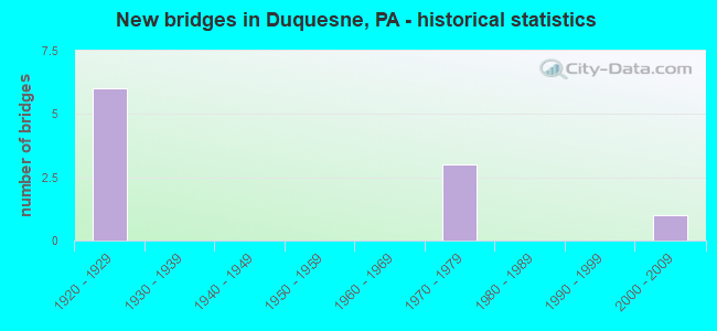
- New bridges - historical statistics
- 61920-1929
- 31970-1979
- 12000-2009

- Reconstructed bridges - Historical Statistics
- 11970-1979
- 21980-1989
- 01990-1999
- 02000-2009
- 12010-2019


- Bridge Condition - Deck
- 20.0%Very good
- 20.0%Good
- 40.0%Satisfactory
- 20.0%Fair

- Bridge Condition - Superstructure
- 20.0%Very good
- 40.0%Satisfactory
- 40.0%Fair

- Bridge Condition - Substructure
- 40.0%Good
- 40.0%Fair
- 20.0%Poor
Find on map >> Show street view
Structure Number: 1277, Location: UNION RR YARD (Lat: 40.378483, Lng: -79.852303), Route carried "on" structure: State highway 837, Year Built: 1928, Year Reconstructed: 1983, Status: Open, Structure Length: 24.63m (80.81ft), Average Daily Traffic: 16,056 (year 2022), Truck Traffic: 5%, Average Future Daily Traffic: 22,093 (year 2032), Design Load: HS 20, Features Intersected: UNION RR, THOMPSON RUN, Facility Carried by Structure: KENNYWOOD BLVD
Minimum Vertical Clearance: 30+ m (98+ ft), Kilometerpoint: 18.746, Lanes on structure: 4, Lanes under structure: 4, Base Highway Network: Yes, Owner: State Highway Agency, Approaching Roadway Width: 14.6m (47.9ft), Skew: 9 degrees, Material/Design: Steel, Design/Construction: Girder and Floorbeam System, Number Of Spans In Main Unit: 8, Length of Maximum Span: 29.9m (98.1ft), Curb or Sidewalk Widths: Left: 1.5m (4.9ft), Right: 0.2m (0.7ft), Curb-To-Curb Width: 14.6m (47.9ft), Out-to-Out Width: 17.7m (58.1ft)
Condition: Deck: Satisfactory, Superstructure: Fair, Substructure: Poor, Channel: Good, Operating Rating: 55.3 metric tons, Method Used To Determine Operating Rating: Load Factor (LF), Inventory Rating: 32.7 metric tons, Method Used To Determine Inventory Rating: Load Factor (LF), Structural Evaluation: Meets minimum limits, Deck Geometry: High priority of replacement, Underclear: Meets minimum limits, Waterway Adequacy: Superior to present desirable criteria, Approach Roadway Alignment: Better than present minimum criteria, Length Of Structure Improvement: 24.60m (80.71ft), Designated Inspection Frequency: Every 24 months, Critical Feature Inspection Frequency: Every 24 months, Inspection Date: September 2020, Critical Feature Inspection Date: September 2020, Bridge Improvement Cost: $191,000, Roadway Improvement Cost: $563,000, Total Project Cost: $2,580,000, Deck Structure Type: Concrete Cast-file-Place, Wearing Surface/Protective System: Wearing Surface: Bituminous, Deck Protection: Epoxy Coated Reinforcing
Find on map >> Show street view
Structure Number: 1668, Location: Duquesne-McKeesport Brg (Lat: 40.357506, Lng: -79.843964), Route carried "on" structure: Spur State highway , Year Built: 1927, Year Reconstructed: 1988, Status: Open, Structure Length: 68.64m (225.20ft), Average Daily Traffic: 22,092 (year 2022), Truck Traffic: 7%, Average Future Daily Traffic: 30,020 (year 2032), Design Load: HS 20, Features Intersected: 736 EXT, 3 RRS, MON.RIV., Facility Carried by Structure: MCKEESPORT-DUQ BRG
Minimum Vertical Clearance: 5.49m (18.01ft), Kilometerpoint: 0.444, Lanes on structure: 2, Lanes under structure: 4, Base Highway Network: Yes, Owner: State Highway Agency, Approaching Roadway Width: 11.6m (38.1ft), Skew: 9 degrees, Navigation Control: Yes ( Vertical Clearance: 68.9m (226.0ft), Horizontal Clearance: 381.9m (1,253.0ft)), Material/Design: Steel, Design/Construction: Truss - Thru, Number Of Spans In Main Unit: 8, Number Of Approach Spans: 1, Length of Maximum Span: 116.4m (381.9ft), Curb or Sidewalk Widths: Left: 2.6m (8.5ft), Right: 2.6m (8.5ft), Curb-To-Curb Width: 11.0m (36.1ft), Out-to-Out Width: 12.8m (42.0ft)
Condition: Deck: Fair, Superstructure: Fair, Substructure: Fair, Channel: Good, Operating Rating: 48.1 metric tons, Method Used To Determine Operating Rating: Allowable Stress (AS), Inventory Rating: 3.6 metric tons, Method Used To Determine Inventory Rating: Allowable Stress (AS), Structural Evaluation: High priority of corrective action, Deck Geometry: Meets minimum limits, Underclear: Meets minimum limits, Waterway Adequacy: Superior to present desirable criteria, Approach Roadway Alignment: High priority of corrective action, Length Of Structure Improvement: 68.60m (225.07ft), Designated Inspection Frequency: Every 24 months, Critical Feature Inspection Frequency: Every 24 months, Underwater Inspection Frequency: Every 60 months, Inspection Date: August 2020, Critical Feature Inspection Date: August 2020, Underwater Inspection Date: August 2020, Bridge Improvement Cost: $134,000, Roadway Improvement Cost: $395,000, Total Project Cost: $1,811,000, Deck Structure Type: Concrete Cast-file-Place, Wearing Surface/Protective System: Wearing Surface: Monolithic Concrete, Deck Protection: Epoxy Coated Reinforcing
Find on map >> Show street view
Structure Number: 2868, Location: Duquesne-McKeesport Bridg (Lat: 40.359528, Lng: -79.846958), Route carried "on" structure: Ramp State highway , Year Built: 1970, Year Reconstructed: 2018, Status: Open, Structure Length: 17.37m (56.99ft), Average Daily Traffic: 4,036 (year 2022), Truck Traffic: 7%, Average Future Daily Traffic: 7,020 (year 2032), Design Load: HS 20, Features Intersected: SR 0837 SB, Facility Carried by Structure: RAMP A
Minimum Vertical Clearance: 30+ m (98+ ft), Kilometerpoint: 0.000, Lanes on structure: 1, Lanes under structure: 1, Base Highway Network: Yes, Owner: State Highway Agency, Approaching Roadway Width: 5.5m (18.0ft), Skew: 9 degrees, Material/Design: Prestressed concrete, Design/Construction: Stringer/Multi-beam, Number Of Spans In Main Unit: 9, Length of Maximum Span: 19.5m (64.0ft), Curb or Sidewalk Widths: Left: 0.2m (0.7ft), Right: 0.2m (0.7ft), Curb-To-Curb Width: 6.4m (21.0ft), Out-to-Out Width: 7.2m (23.6ft)
Condition: Deck: Good, Superstructure: Satisfactory, Substructure: Good, Operating Rating: 58.1 metric tons, Method Used To Determine Operating Rating: Load Factor (LF), Inventory Rating: 32.7 metric tons, Method Used To Determine Inventory Rating: Load Factor (LF), Structural Evaluation: Equal to present minimum criteria, Deck Geometry: Somewhat better than minimum adequacy, Underclear: Equal to present minimum criteria, Approach Roadway Alignment: High priority of corrective action, Length Of Structure Improvement: 17.40m (57.09ft), Designated Inspection Frequency: Every 24 months, Critical Feature Inspection Frequency: Every 24 months, Inspection Date: August 2020, Critical Feature Inspection Date: August 2020, Bridge Improvement Cost: $20,000, Roadway Improvement Cost: $58,000, Total Project Cost: $265,000, Deck Structure Type: Concrete Cast-file-Place, Wearing Surface/Protective System: Wearing Surface: Bituminous, Deck Protection: Epoxy Coated Reinforcing
Find on map >> Show street view
Structure Number: 2869, Location: AT MCKEESPORT-DUQESNE (Lat: 40.359458, Lng: -79.846900), Route carried "on" structure: State highway , Year Built: 1970, Year Reconstructed: 1988, Status: Open, Structure Length: 7.99m (26.21ft), Average Daily Traffic: 2,107 (year 2022), Truck Traffic: 7%, Average Future Daily Traffic: 5,420 (year 2032), Design Load: HS 20, Features Intersected: RAILROAD PROPERTY, Facility Carried by Structure: NB BYPASS
Minimum Vertical Clearance: 30+ m (98+ ft), Kilometerpoint: 0.000, Lanes on structure: 1, Base Highway Network: Yes, Owner: State Highway Agency, Approaching Roadway Width: 6.4m (21.0ft), Skew: 9 degrees, Material/Design: Prestressed concrete, Design/Construction: Stringer/Multi-beam, Number Of Spans In Main Unit: 4, Length of Maximum Span: 19.8m (65.0ft), Curb or Sidewalk Widths: Left: 0.2m (0.7ft), Right: 0.2m (0.7ft), Curb-To-Curb Width: 6.4m (21.0ft), Out-to-Out Width: 7.1m (23.3ft)
Condition: Deck: Satisfactory, Superstructure: Satisfactory, Substructure: Fair, Operating Rating: 57.2 metric tons, Method Used To Determine Operating Rating: Load Factor (LF), Inventory Rating: 34.5 metric tons, Method Used To Determine Inventory Rating: Load Factor (LF), Structural Evaluation: Somewhat better than minimum adequacy, Deck Geometry: High priority of replacement, Approach Roadway Alignment: Better than present minimum criteria, Length Of Structure Improvement: 8.00m (26.25ft), Designated Inspection Frequency: Every 24 months, Inspection Date: August 2020, Bridge Improvement Cost: $18,000, Roadway Improvement Cost: $52,000, Total Project Cost: $241,000, Deck Structure Type: Concrete Cast-file-Place, Wearing Surface/Protective System: Wearing Surface: Monolithic Concrete, Deck Protection: Epoxy Coated Reinforcing
Find on map >> Show street view
Structure Number: 45729, Location: FO02 Duquesne Flyover (Lat: 40.363664, Lng: -79.842206), Route carried "on" structure: City street , Year Built: 2009, Status: Open, Structure Length: 2.62m (8.60ft), Average Daily Traffic: 434 (year 2011), Truck Traffic: 1%, Average Future Daily Traffic: 474 (year 2030), Design Load: HS 20, Features Intersected: N-S RR, Facility Carried by Structure: S. LINDEN ST.
Minimum Vertical Clearance: 30+ m (98+ ft), Kilometerpoint: 0.000, Lanes on structure: 3, Owner: County Highway Agency, Approaching Roadway Width: 15.8m (51.8ft), Material/Design: Steel, Design/Construction: Girder and Floorbeam System, Number Of Spans In Main Unit: 1, Length of Maximum Span: 24.7m (81.0ft), Curb or Sidewalk Widths: Left: 0.3m (1.0ft), Right: 0.2m (0.7ft), Curb-To-Curb Width: 15.8m (51.8ft), Out-to-Out Width: 18.7m (61.4ft)
Condition: Deck: Very good, Superstructure: Very good, Substructure: Good, Operating Rating: 74.4 metric tons, Method Used To Determine Operating Rating: Load Factor (LF), Inventory Rating: 44.5 metric tons, Method Used To Determine Inventory Rating: Load Factor (LF), Structural Evaluation: Better than present minimum criteria, Deck Geometry: Better than present minimum criteria, Underclear: High priority of corrective action, Approach Roadway Alignment: Equal to present minimum criteria, Designated Inspection Frequency: Every 24 months, Inspection Date: October 2021, Deck Structure Type: Corrugated Steel, Wearing Surface/Protective System: Wearing Surface: Monolithic Concrete, Deck Protection: Epoxy Coated Reinforcing
Find on map >> Show street view
Structure Number: 1277, Location: UNION RR YARD (Lat: 40.378483, Lng: -79.852303), Route carried "under" structure: Business Other road , Year Built: 1928, Structure Length: 0. m, Average Daily Traffic: 50 (year 1997), Features Intersected: UNION RR, THOMPSON RUN, Facility Carried by Structure: KENNYWOOD BLVD
Minimum Vertical Clearance: 8.59m (28.18ft), Kilometerpoint: 0.000, Lanes on structure: 4, Lanes under structure: 2, Material/Design: Steel, Design/Construction: Girder and Floorbeam System, Length of Maximum Span: 29.9m (98.1ft)
Find on map >> Show street view
Structure Number: 1277, Location: UNION RR YARD (Lat: 40.378483, Lng: -79.852303), Route carried "under" structure: Business Other road , Year Built: 1928, Structure Length: 0. m, Average Daily Traffic: 50 (year 1997), Features Intersected: UNION RR, THOMPSON RUN, Facility Carried by Structure: KENNYWOOD BLVD
Minimum Vertical Clearance: 6.00m (19.69ft), Kilometerpoint: 0.000, Lanes on structure: 4, Lanes under structure: 2, Material/Design: Steel, Design/Construction: Girder and Floorbeam System, Length of Maximum Span: 29.9m (98.1ft)
Find on map >> Show street view
Structure Number: 1668, Location: Duquesne-McKeesport Brg (Lat: 40.357506, Lng: -79.843964), Route carried "under" structure: State highway , Year Built: 1927, Structure Length: 0. m, Average Daily Traffic: 2,107 (year 2022), Truck Traffic: 7%, Features Intersected: 736 EXT, 3 RRS, MON.RIV., Facility Carried by Structure: MCKEESPORT-DUQ BRG
Minimum Vertical Clearance: 4.52m (14.83ft), Kilometerpoint: 0.000, Lanes on structure: 2, Lanes under structure: 2, Material/Design: Steel, Design/Construction: Truss - Thru, Length of Maximum Span: 116.4m (381.9ft)
Find on map >> Show street view
Structure Number: 1668, Location: Duquesne-McKeesport Brg (Lat: 40.357506, Lng: -79.843964), Route carried "under" structure: Ramp State highway , Year Built: 1927, Structure Length: 0. m, Average Daily Traffic: 4,056 (year 2022), Truck Traffic: 7%, Features Intersected: 736 EXT, 3 RRS, MON.RIV., Facility Carried by Structure: MCKEESPORT-DUQ BRG
Minimum Vertical Clearance: 4.57m (14.99ft), Kilometerpoint: 0.000, Lanes on structure: 2, Lanes under structure: 2, Material/Design: Steel, Design/Construction: Truss - Thru, Length of Maximum Span: 116.4m (381.9ft)
Find on map >> Show street view
Structure Number: 2868, Location: Duquesne-McKeesport Bridg (Lat: 40.359528, Lng: -79.846958), Route carried "under" structure: Ramp State highway , Year Built: 1970, Structure Length: 0. m, Average Daily Traffic: 4,056 (year 2022), Truck Traffic: 7%, Features Intersected: SR 0837 SB, Facility Carried by Structure: RAMP A
Minimum Vertical Clearance: 4.57m (14.99ft), Kilometerpoint: 0.000, Lanes on structure: 1, Lanes under structure: 1, Material/Design: Prestressed concrete, Design/Construction: Stringer/Multi-beam, Length of Maximum Span: 19.5m (64.0ft)