Bridge Statistics for Dupo, Illinois (IL)
Condition, Traffic, Stress, Structural Evaluation, Project Costs
- National Bridge Inventory (NBI) Statistics
- 18Number of bridges
- 266ft / 80.9mTotal length
- $348,000Total costs
- 298,575Total average daily traffic
- 42,213Total average daily truck traffic
- National Bridge Inventory (NBI) Registered Bridges for Dupo
- No street view available for this location
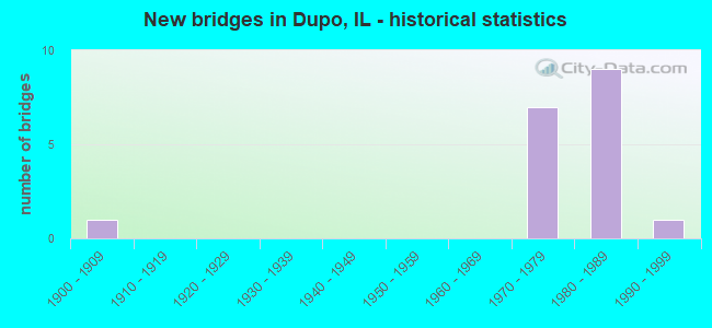
- New bridges - historical statistics
- 11900-1909
- 71970-1979
- 91980-1989
- 11990-1999


- Bridge Condition - Deck
- 16.7%Very good
- 83.3%Good

- Bridge Condition - Superstructure
- 16.7%Very good
- 66.7%Satisfactory
- 16.7%Fair

- Bridge Condition - Channel
- 20.0%Very good
- 60.0%Good
- 20.0%Satisfactory

- Bridge Condition - Culverts
- 50.0%Very good
- 50.0%Good
Find on map >> Show street view
Structure Number: 820215, Location: 1.5 MI. S OF DUPO (Lat: 38.489983, Lng: -90.217972), Route carried "on" structure: Other road , Year Built: 1979, Status: Open, Structure Length: 6.75m (22.15ft), Average Daily Traffic: 625 (year 2018), Truck Traffic: 7%, Average Future Daily Traffic: 1,046 (year 2032), Design Load: HS 20+Mod, Features Intersected: FAI 255, Facility Carried by Structure: Davis St Ferry Rd
Minimum Vertical Clearance: 30+ m (98+ ft), Kilometerpoint: 4.989, Lanes on structure: 2, Lanes under structure: 6, Owner: State Highway Agency, Approaching Roadway Width: 10.4m (34.1ft), Skew: 2 degrees, Material/Design: Steel continuous, Design/Construction: Stringer/Multi-beam, Number Of Spans In Main Unit: 2, Length of Maximum Span: 34.4m (112.9ft), Curb-To-Curb Width: 10.4m (34.1ft), Out-to-Out Width: 11.3m (37.1ft)
Condition: Deck: Good, Superstructure: Satisfactory, Substructure: Good, Operating Rating: 57.7 metric tons, Method Used To Determine Operating Rating: Allowable Stress (AS) rating reported by rating factor (RF) method using MS18 loading, Inventory Rating: 33.4 metric tons, Method Used To Determine Inventory Rating: Allowable Stress (AS) rating reported by rating factor (RF) method using MS18 loading, Structural Evaluation: Equal to present minimum criteria, Deck Geometry: Equal to present minimum criteria, Underclear: Somewhat better than minimum adequacy, Approach Roadway Alignment: Equal to present desirable criteria, Designated Inspection Frequency: Every 24 months, Inspection Date: January 2021, Deck Structure Type: Concrete Cast-file-Place, Wearing Surface/Protective System: Deck Protection: Epoxy Coated Reinforcing
Find on map >> Show street view
Structure Number: 820216, Location: 0.1MI SE DUPO (Lat: 38.508781, Lng: -90.205133), Route carried "on" structure: Other road , Year Built: 1983, Status: Open, Structure Length: 7.69m (25.23ft), Average Daily Traffic: 7,150 (year 2018), Truck Traffic: 10%, Average Future Daily Traffic: 8,473 (year 2032), Design Load: HS 20, Features Intersected: FAI 255, Facility Carried by Structure: S Main St/Old IL 3
Minimum Vertical Clearance: 30+ m (98+ ft), Kilometerpoint: 4.442, Lanes on structure: 2, Lanes under structure: 6, Base Highway Network: Yes, Owner: State Highway Agency, Approaching Roadway Width: 18.9m (62.0ft), Skew: 32 degrees, Material/Design: Steel continuous, Design/Construction: Stringer/Multi-beam, Number Of Spans In Main Unit: 2, Length of Maximum Span: 41.1m (134.8ft), Curb-To-Curb Width: 20.1m (65.9ft), Out-to-Out Width: 21.1m (69.2ft)
Condition: Deck: Good, Superstructure: Satisfactory, Substructure: Good, Operating Rating: 63.8 metric tons, Method Used To Determine Operating Rating: Load Factor (LF) rating reported by rating factor (RF) method using MS18 loading, Inventory Rating: 37.9 metric tons, Method Used To Determine Inventory Rating: Load Factor (LF) rating reported by rating factor (RF) method using MS18 loading, Structural Evaluation: Equal to present minimum criteria, Deck Geometry: Superior to present desirable criteria, Underclear: Meets minimum limits, Approach Roadway Alignment: Equal to present desirable criteria, Designated Inspection Frequency: Every 24 months, Inspection Date: January 2021, Deck Structure Type: Concrete Cast-file-Place, Wearing Surface/Protective System: Deck Protection: Epoxy Coated Reinforcing
Find on map >> Show street view
Structure Number: 820217, Location: N DUPO (Lat: 38.530939, Lng: -90.196703), Route carried "on" structure: State highway 3, Year Built: 1983, Status: Open, Structure Length: 29.35m (96.29ft), Average Daily Traffic: 7,850 (year 2021), Truck Traffic: 15%, Average Future Daily Traffic: 5,805 (year 2032), Design Load: HS 20, Features Intersected: FAI 255
Minimum Vertical Clearance: 30+ m (98+ ft), Kilometerpoint: 222.759, Lanes on structure: 2, Lanes under structure: 7, Base Highway Network: Yes, Owner: State Highway Agency, Approaching Roadway Width: 12.3m (40.4ft), Skew: 3 degrees, Material/Design: Steel continuous, Design/Construction: Stringer/Multi-beam, Number Of Spans In Main Unit: 7, Length of Maximum Span: 51.5m (169.0ft), Curb-To-Curb Width: 12.2m (40.0ft), Out-to-Out Width: 13.1m (43.0ft)
Condition: Deck: Good, Superstructure: Satisfactory, Substructure: Good, Operating Rating: 60.3 metric tons, Method Used To Determine Operating Rating: Load Factor (LF) rating reported by rating factor (RF) method using MS18 loading, Inventory Rating: 36.3 metric tons, Method Used To Determine Inventory Rating: Load Factor (LF) rating reported by rating factor (RF) method using MS18 loading, Structural Evaluation: Equal to present minimum criteria, Deck Geometry: Better than present minimum criteria, Underclear: Meets minimum limits, Approach Roadway Alignment: Equal to present desirable criteria, Designated Inspection Frequency: Every 24 months, Inspection Date: January 2021, Deck Structure Type: Concrete Cast-file-Place, Wearing Surface/Protective System: Deck Protection: Epoxy Coated Reinforcing
Find on map >> Show street view
Structure Number: 820218, Location: N DUPO (Lat: 38.530794, Lng: -90.196653), Route carried "on" structure: State highway 3, Year Built: 1981, Status: Open, Structure Length: 26.85m (88.09ft), Average Daily Traffic: 7,850 (year 2021), Truck Traffic: 15%, Average Future Daily Traffic: 5,805 (year 2032), Design Load: HS 20, Features Intersected: FAI 255
Minimum Vertical Clearance: 30+ m (98+ ft), Kilometerpoint: 222.743, Lanes on structure: 1, Lanes under structure: 7, Base Highway Network: Yes, Owner: State Highway Agency, Approaching Roadway Width: 7.9m (25.9ft), Skew: 3 degrees, Material/Design: Steel continuous, Design/Construction: Stringer/Multi-beam, Number Of Spans In Main Unit: 7, Length of Maximum Span: 44.5m (146.0ft), Curb-To-Curb Width: 7.9m (25.9ft), Out-to-Out Width: 8.9m (29.2ft)
Condition: Deck: Good, Superstructure: Satisfactory, Substructure: Good, Operating Rating: 55.4 metric tons, Method Used To Determine Operating Rating: Load Factor (LF) rating reported by rating factor (RF) method using MS18 loading, Inventory Rating: 33.4 metric tons, Method Used To Determine Inventory Rating: Load Factor (LF) rating reported by rating factor (RF) method using MS18 loading, Structural Evaluation: Equal to present minimum criteria, Deck Geometry: High priority of corrective action, Underclear: Meets minimum limits, Approach Roadway Alignment: Equal to present desirable criteria, Designated Inspection Frequency: Every 24 months, Inspection Date: January 2021, Deck Structure Type: Concrete Cast-file-Place, Wearing Surface/Protective System: Deck Protection: Epoxy Coated Reinforcing
Find on map >> Show street view
Structure Number: 820219, Location: 1/2 mi S of IL 157 (Lat: 38.537114, Lng: -90.185022), Route carried "on" structure: Interstate 255, Year Built: 1979, Status: Open, Structure Length: 2.71m (8.89ft), Average Daily Traffic: 33,000 (year 2021), Truck Traffic: 17%, Average Future Daily Traffic: 38,284 (year 2032), Design Load: HS 20+Mod, Features Intersected: MCBRIDE AVE/TR12
Minimum Vertical Clearance: 30+ m (98+ ft), Kilometerpoint: 12.359, Lanes on structure: 6, Lanes under structure: 2, Base Highway Network: Yes, Owner: State Highway Agency, Approaching Roadway Width: 34.1m (111.9ft), Skew: 30 degrees, Material/Design: Steel, Design/Construction: Stringer/Multi-beam, Number Of Spans In Main Unit: 1, Length of Maximum Span: 26.4m (86.6ft), Curb-To-Curb Width: 34.1m (111.9ft), Out-to-Out Width: 36.9m (121.1ft)
Condition: Deck: Good, Superstructure: Fair, Substructure: Good, Operating Rating: 74.2 metric tons, Method Used To Determine Operating Rating: Load Factor (LF) rating reported by rating factor (RF) method using MS18 loading, Inventory Rating: 44.4 metric tons, Method Used To Determine Inventory Rating: Load Factor (LF) rating reported by rating factor (RF) method using MS18 loading, Structural Evaluation: Somewhat better than minimum adequacy, Deck Geometry: Superior to present desirable criteria, Underclear: Superior to present desirable criteria, Approach Roadway Alignment: Equal to present desirable criteria, Designated Inspection Frequency: Every 24 months, Inspection Date: January 2021, Deck Structure Type: Concrete Cast-file-Place, Wearing Surface/Protective System: Deck Protection: Epoxy Coated Reinforcing
Find on map >> Show street view
Structure Number: 822017, Location: 1.5 MI S OF DUPO (Lat: 38.489850, Lng: -90.218036), Route carried "on" structure: Interstate 255, Year Built: 1979, Status: Open, Structure Length: 1.85m (6.07ft), Average Daily Traffic: 45,600 (year 2021), Truck Traffic: 11%, Average Future Daily Traffic: 43,618 (year 2032), Design Load: HS 20+Mod, Features Intersected: HILL CREEK
Minimum Vertical Clearance: 30+ m (98+ ft), Kilometerpoint: 6.196, Lanes on structure: 6, Base Highway Network: Yes, Owner: State Highway Agency, Approaching Roadway Width: 34.1m (111.9ft), Skew: 10 degrees, Material/Design: Concrete continuous, Design/Construction: Culvert, Number Of Spans In Main Unit: 4, Length of Maximum Span: 4.9m (16.1ft)
Condition: Channel: Good, Culverts: Good, Operating Rating: 78.1 metric tons, Method Used To Determine Operating Rating: Load Factor (LF) rating reported by rating factor (RF) method using MS18 loading, Inventory Rating: 46.7 metric tons, Method Used To Determine Inventory Rating: Load Factor (LF) rating reported by rating factor (RF) method using MS18 loading, Structural Evaluation: Better than present minimum criteria, Waterway Adequacy: Superior to present desirable criteria, Approach Roadway Alignment: Equal to present desirable criteria, Designated Inspection Frequency: Every 24 months, Inspection Date: January 2021
Find on map >> Show street view
Structure Number: 822018, Location: 1.5 M SO OF DUPO (Lat: 38.490028, Lng: -90.219331), Route carried "on" structure: City street , Year Built: 1979, Status: Open, Structure Length: 1.42m (4.66ft), Average Daily Traffic: 200 (year 2013), Truck Traffic: 10%, Average Future Daily Traffic: 235 (year 2032), Design Load: HS 20+Mod, Features Intersected: HILL CREEK, Facility Carried by Structure: MSS 6035
Minimum Vertical Clearance: 30+ m (98+ ft), Kilometerpoint: 0.129, Lanes on structure: 6, Owner: City or Municipal Highway Agency, Approaching Roadway Width: 6.1m (20.0ft), Skew: 1 degrees, Material/Design: Concrete, Design/Construction: Culvert, Number Of Spans In Main Unit: 4, Length of Maximum Span: 3.5m (11.5ft)
Condition: Channel: Good, Culverts: Good, Operating Rating: 78.1 metric tons, Method Used To Determine Operating Rating: Load Factor (LF) rating reported by rating factor (RF) method using MS18 loading, Inventory Rating: 46.7 metric tons, Method Used To Determine Inventory Rating: Load Factor (LF) rating reported by rating factor (RF) method using MS18 loading, Structural Evaluation: Better than present minimum criteria, Waterway Adequacy: Better than present minimum criteria, Approach Roadway Alignment: Equal to present minimum criteria, Designated Inspection Frequency: Every 48 months, Inspection Date: April 2021, Wearing Surface/Protective System: Wearing Surface: Other
Find on map >> Show street view
Structure Number: 82202, Location: under S Main St Dupo (Lat: 38.509011, Lng: -90.204575), Route carried "on" structure: Interstate 255, Year Built: 1983, Status: Open, Structure Length: 0.97m (3.18ft), Average Daily Traffic: 38,900 (year 2021), Truck Traffic: 15%, Average Future Daily Traffic: 47,698 (year 2032), Design Load: HS 20+Mod, Features Intersected: PRAIRIE LAKE DITCH
Minimum Vertical Clearance: 30+ m (98+ ft), Kilometerpoint: 8.594, Lanes on structure: 6, Base Highway Network: Yes, Owner: State Highway Agency, Approaching Roadway Width: 20.7m (67.9ft), Skew: 3 degrees, Material/Design: Concrete continuous, Design/Construction: Culvert, Number Of Spans In Main Unit: 3, Length of Maximum Span: 3.4m (11.2ft)
Condition: Channel: Very good, Culverts: Very good, Operating Rating: 97.2 metric tons, Method Used To Determine Operating Rating: Load Factor (LF) rating reported by rating factor (RF) method using MS18 loading, Inventory Rating: 75.2 metric tons, Method Used To Determine Inventory Rating: Load Factor (LF) rating reported by rating factor (RF) method using MS18 loading, Structural Evaluation: Equal to present desirable criteria, Waterway Adequacy: Equal to present desirable criteria, Approach Roadway Alignment: Equal to present desirable criteria, Designated Inspection Frequency: Every 24 months, Inspection Date: January 2021
Find on map >> Show street view
Structure Number: 822038, Location: 1.1M S DUPO (Lat: 38.493539, Lng: -90.213392), Route carried "on" structure: Other road , Year Built: 1997, Status: Open, Structure Length: 0.84m (2.76ft), Average Daily Traffic: 2,300 (year 2018), Truck Traffic: 5%, Average Future Daily Traffic: 2,406 (year 2032), Design Load: HS 20, Features Intersected: HILL CREEK, Facility Carried by Structure: OLD IL 3 - FAU 929
Minimum Vertical Clearance: 30+ m (98+ ft), Kilometerpoint: 6.437, Lanes on structure: 2, Base Highway Network: Yes, Owner: State Highway Agency, Approaching Roadway Width: 7.3m (24.0ft), Skew: 1 degrees, Material/Design: Concrete continuous, Design/Construction: Culvert, Number Of Spans In Main Unit: 2, Length of Maximum Span: 3.8m (12.5ft)
Condition: Channel: Satisfactory, Culverts: Very good, Operating Rating: 69.0 metric tons, Method Used To Determine Operating Rating: Load Factor (LF) rating reported by rating factor (RF) method using MS18 loading, Inventory Rating: 41.5 metric tons, Method Used To Determine Inventory Rating: Load Factor (LF) rating reported by rating factor (RF) method using MS18 loading, Structural Evaluation: Equal to present desirable criteria, Waterway Adequacy: Equal to present minimum criteria, Approach Roadway Alignment: Equal to present desirable criteria, Designated Inspection Frequency: Every 48 months, Inspection Date: September 2021
Find on map >> Show street view
Structure Number: 823058, Location: 1.25MI W ILL RTE 3 (Lat: 38.503922, Lng: -90.228667), Route carried "on" structure: Other road , Year Built: 1974, Year Reconstructed: 2011, Status: Open, Structure Length: 2.50m (8.20ft), Average Daily Traffic: 500 (year 2018), Truck Traffic: 11%, Average Future Daily Traffic: 418 (year 2032), Design Load: HS 25 or greater, Features Intersected: FISH LAKE, Facility Carried by Structure: DAVIS ST/ FAU 9301
Minimum Vertical Clearance: 30+ m (98+ ft), Kilometerpoint: 3.219, Lanes on structure: 2, Owner: County Highway Agency, Approaching Roadway Width: 6.7m (22.0ft), Skew: 3 degrees, Material/Design: Prestressed concrete, Design/Construction: Box Beam or Girders - Multiple, Number Of Spans In Main Unit: 3, Length of Maximum Span: 11.0m (36.1ft), Curb-To-Curb Width: 9.2m (30.2ft), Out-to-Out Width: 9.2m (30.2ft)
Condition: Deck: Very good, Superstructure: Very good, Substructure: Good, Channel: Good, Operating Rating: 62.9 metric tons, Method Used To Determine Operating Rating: Load Factor (LF) rating reported by rating factor (RF) method using MS18 loading, Inventory Rating: 37.9 metric tons, Method Used To Determine Inventory Rating: Load Factor (LF) rating reported by rating factor (RF) method using MS18 loading, Structural Evaluation: Better than present minimum criteria, Deck Geometry: Equal to present minimum criteria, Waterway Adequacy: Better than present minimum criteria, Approach Roadway Alignment: Equal to present desirable criteria, Length Of Structure Improvement: 2.32m (7.61ft), Designated Inspection Frequency: Every 48 months, Inspection Date: March 2020, Bridge Improvement Cost: $336,000, Roadway Improvement Cost: $12,000, Total Project Cost: $348,000, Deck Structure Type: Concrete Precast Panels, Wearing Surface/Protective System: Wearing Surface: Bituminous, Membrane: Built-up, Deck Protection: Epoxy Coated Reinforcing
Find on map >> Show street view
Structure Number: 820215, Location: 1.5 MI. S OF DUPO (Lat: 38.489983, Lng: -90.217972), Route carried "under" structure: Interstate 255, Year Built: 1979, Structure Length: 0. m, Average Daily Traffic: 45,600 (year 2021), Truck Traffic: 11%, Features Intersected: FAI 255, Facility Carried by Structure: Davis St Ferry Rd
Minimum Vertical Clearance: 5.26m (17.26ft), Kilometerpoint: 6.212, Lanes on structure: 2, Lanes under structure: 6, Material/Design: Steel continuous, Design/Construction: Stringer/Multi-beam, Length of Maximum Span: 34.4m (112.9ft)
Find on map >> Show street view
Structure Number: 820216, Location: 0.1MI SE DUPO (Lat: 38.508531, Lng: -90.204919), Route carried "under" structure: Interstate 255, Year Built: 1983, Structure Length: 0. m, Average Daily Traffic: 38,900 (year 2021), Truck Traffic: 15%, Features Intersected: FAI 255, Facility Carried by Structure: S Main St/Old IL 3
Minimum Vertical Clearance: 5.11m (16.77ft), Kilometerpoint: 8.578, Lanes on structure: 2, Lanes under structure: 6, Material/Design: Steel continuous, Design/Construction: Stringer/Multi-beam, Length of Maximum Span: 41.1m (134.8ft)
Find on map >> Show street view
Structure Number: 820217, Location: N DUPO (Lat: 38.528675, Lng: -90.197244), Route carried "under" structure: Other road , Year Built: 1983, Structure Length: 0. m, Average Daily Traffic: 500 (year 2018), Truck Traffic: 10%, Features Intersected: FAI 255, Facility Carried by Structure: IL 3 NB Ramp E
Minimum Vertical Clearance: 5.97m (19.59ft), Kilometerpoint: 0.966, Lanes on structure: 2, Lanes under structure: 1, Material/Design: Steel continuous, Design/Construction: Stringer/Multi-beam, Length of Maximum Span: 51.5m (169.0ft)
Find on map >> Show street view
Structure Number: 820217, Location: N DUPO (Lat: 38.530358, Lng: -90.195961), Route carried "under" structure: Interstate 255, Year Built: 1983, Structure Length: 0. m, Average Daily Traffic: 33,000 (year 2021), Truck Traffic: 17%, Features Intersected: FAI 255, Facility Carried by Structure: IL 3 NB Ramp E
Minimum Vertical Clearance: 5.97m (19.59ft), Kilometerpoint: 11.136, Lanes on structure: 2, Lanes under structure: 6, Material/Design: Steel continuous, Design/Construction: Stringer/Multi-beam, Length of Maximum Span: 51.5m (169.0ft)
Find on map >> Show street view
Structure Number: 820218, Location: N DUPO (Lat: 38.528544, Lng: -90.197303), Route carried "under" structure: Other road , Year Built: 1981, Structure Length: 0. m, Average Daily Traffic: 500 (year 2018), Truck Traffic: 10%, Features Intersected: FAI 255, Facility Carried by Structure: IL 3 SB Ramp F
Minimum Vertical Clearance: 5.72m (18.77ft), Kilometerpoint: 0.933, Lanes on structure: 1, Lanes under structure: 1, Material/Design: Steel continuous, Design/Construction: Stringer/Multi-beam, Length of Maximum Span: 44.5m (146.0ft)
Find on map >> Show street view
Structure Number: 820218, Location: N DUPO (Lat: 38.529947, Lng: -90.196331), Route carried "under" structure: Interstate 255, Year Built: 1981, Structure Length: 0. m, Average Daily Traffic: 33,000 (year 2021), Truck Traffic: 17%, Features Intersected: FAI 255, Facility Carried by Structure: IL 3 SB Ramp F
Minimum Vertical Clearance: 5.72m (18.77ft), Kilometerpoint: 11.104, Lanes on structure: 1, Lanes under structure: 6, Material/Design: Steel continuous, Design/Construction: Stringer/Multi-beam, Length of Maximum Span: 44.5m (146.0ft)
Find on map >> Show street view
Structure Number: 820219, Location: 1/2 mi S of IL 157 (Lat: 38.537114, Lng: -90.185022), Route carried "under" structure: County highway , Year Built: 1979, Structure Length: 0. m, Average Daily Traffic: 1,550 (year 2018), Truck Traffic: 6%, Features Intersected: MCBRIDE AVE/TR12, Facility Carried by Structure: I 255
Minimum Vertical Clearance: 4.70m (15.42ft), Kilometerpoint: 1.255, Lanes on structure: 6, Lanes under structure: 2, Material/Design: Steel, Design/Construction: Stringer/Multi-beam, Length of Maximum Span: 26.4m (86.6ft)
Find on map >> Show street view
Structure Number: 829922, Location: EAST CARONDELET (Lat: 38.523367, Lng: -90.211006), Route carried "under" structure: Other road , Year Built: 1900, Structure Length: 0. m, Average Daily Traffic: 1,550 (year 2018), Truck Traffic: 12%, Features Intersected: SCHOOL ST/ FAU 9209, Facility Carried by Structure: RAILROAD
Minimum Vertical Clearance: 4.57m (14.99ft), Kilometerpoint: 2.929, Lanes under structure: 2, Material/Design: Concrete, Length of Maximum Span: 5.5m (18.0ft)