Bridge Statistics for Dunlap, Illinois (IL)
Condition, Traffic, Stress, Structural Evaluation, Project Costs
- National Bridge Inventory (NBI) Statistics
- 16Number of bridges
- 135ft / 40.8mTotal length
- $288,000Total costs
- 17,725Total average daily traffic
- 887Total average daily truck traffic
- 21,333Total future (year 2027) average daily traffic
- National Bridge Inventory (NBI) Registered Bridges for Dunlap
- No street view available for this location
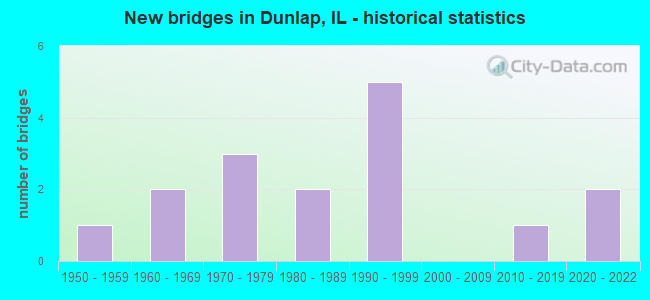
- New bridges - historical statistics
- 11950-1959
- 21960-1969
- 31970-1979
- 21980-1989
- 51990-1999
- 12010-2019
- 22020-2022


- Bridge Condition - Deck
- 16.7%Excellent
- 16.7%Very good
- 25.0%Good
- 41.7%Satisfactory

- Bridge Condition - Superstructure
- 16.7%Excellent
- 16.7%Very good
- 33.3%Good
- 33.3%Satisfactory

- Bridge Condition - Substructure
- 16.7%Excellent
- 8.3%Very good
- 41.7%Good
- 16.7%Satisfactory
- 16.7%Fair

- Bridge Condition - Channel
- 6.7%Excellent
- 26.7%Good
- 26.7%Satisfactory
- 26.7%Fair
- 13.3%Poor

- Bridge Condition - Culverts
- 25.0%Good
- 25.0%Satisfactory
- 25.0%Fair
- 25.0%Poor
Find on map >> Show street view
Structure Number: 554113, Location: S.CTR-29-T7NR1W (Lat: 40.854686, Lng: -89.736419), Route carried "on" structure: County highway , Year Built: 2020, Status: Open, Structure Length: 2.51m (8.23ft), Average Daily Traffic: 200 (year 2017), Truck Traffic: 10%, Average Future Daily Traffic: 400 (year 2031), Design Load: HS 25 or greater, Features Intersected: DROWNING FORK, Facility Carried by Structure: TR 55
Minimum Vertical Clearance: 30+ m (98+ ft), Kilometerpoint: 1.883, Lanes on structure: 2, Owner: Town or Township Highway Agency, Approaching Roadway Width: 9.1m (29.9ft), Material/Design: Prestressed concrete, Design/Construction: Box Beam or Girders - Multiple, Number Of Spans In Main Unit: 1, Length of Maximum Span: 24.2m (79.4ft), Curb-To-Curb Width: 8.5m (27.9ft), Out-to-Out Width: 8.5m (27.9ft)
Condition: Deck: Excellent, Superstructure: Excellent, Substructure: Excellent, Channel: Excellent, Operating Rating: 48.9 metric tons, Method Used To Determine Operating Rating: Load and Resistance Factor Rating (LRFR) rating reported by rating factor(RF) method using HL-93 loadings, Inventory Rating: 38.6 metric tons, Method Used To Determine Inventory Rating: Load and Resistance Factor Rating (LRFR) rating reported by rating factor(RF) method using HL-93 loadings, Structural Evaluation: Superior to present desirable criteria, Deck Geometry: Equal to present minimum criteria, Waterway Adequacy: Superior to present desirable criteria, Approach Roadway Alignment: Superior to present desirable criteria, Designated Inspection Frequency: Every 24 months, Inspection Date: August 2021, Deck Structure Type: Concrete Precast Panels, Wearing Surface/Protective System: Wearing Surface: Bituminous, Membrane: Built-up, Deck Protection: Epoxy Coated Reinforcing
Find on map >> Show street view
Structure Number: 720155, Location: 1.5 MI S OF DUNLAP (Lat: 40.840686, Lng: -89.680567), Route carried "on" structure: State highway 91, Year Built: 1987, Status: Open, Structure Length: 5.94m (19.49ft), Average Daily Traffic: 6,100 (year 2021), Truck Traffic: 3%, Average Future Daily Traffic: 7,753 (year 2032), Design Load: HS 20, Features Intersected: KICKAPOO CR
Minimum Vertical Clearance: 30+ m (98+ ft), Kilometerpoint: 8.143, Lanes on structure: 2, Base Highway Network: Yes, Owner: State Highway Agency, Approaching Roadway Width: 10.4m (34.1ft), Material/Design: Prestressed concrete continuous, Design/Construction: Stringer/Multi-beam, Number Of Spans In Main Unit: 3, Length of Maximum Span: 23.8m (78.1ft), Curb-To-Curb Width: 10.4m (34.1ft), Out-to-Out Width: 11.3m (37.1ft)
Condition: Deck: Satisfactory, Superstructure: Good, Substructure: Fair, Channel: Fair, Operating Rating: 72.3 metric tons, Method Used To Determine Operating Rating: Load Factor (LF) rating reported by rating factor (RF) method using MS18 loading, Inventory Rating: 43.4 metric tons, Method Used To Determine Inventory Rating: Load Factor (LF) rating reported by rating factor (RF) method using MS18 loading, Structural Evaluation: Somewhat better than minimum adequacy, Deck Geometry: Meets minimum limits, Waterway Adequacy: Equal to present minimum criteria, Approach Roadway Alignment: Equal to present desirable criteria, Designated Inspection Frequency: Every 24 months, Underwater Inspection Frequency: Every 12 months, Inspection Date: June 2020, Underwater Inspection Date: June 2021, Deck Structure Type: Concrete Cast-file-Place, Wearing Surface/Protective System: Deck Protection: Epoxy Coated Reinforcing
Find on map >> Show street view
Structure Number: 72201, Location: 1.4 MI S OF ILL 90 (Lat: 40.907394, Lng: -89.677925), Route carried "on" structure: State highway 91, Year Built: 1977, Year Reconstructed: 2001, Status: Open, Structure Length: 0.79m (2.59ft), Average Daily Traffic: 2,200 (year 2021), Truck Traffic: 7%, Average Future Daily Traffic: 3,027 (year 2032), Design Load: HS 20, Features Intersected: BR OF KICKAPOO
Minimum Vertical Clearance: 30+ m (98+ ft), Kilometerpoint: 15.626, Lanes on structure: 2, Owner: State Highway Agency, Approaching Roadway Width: 12.0m (39.4ft), Material/Design: Concrete continuous, Design/Construction: Culvert, Number Of Spans In Main Unit: 2, Length of Maximum Span: 3.4m (11.2ft)
Condition: Channel: Fair, Culverts: Satisfactory, Operating Rating: 97.2 metric tons, Method Used To Determine Operating Rating: Load Factor (LF) rating reported by rating factor (RF) method using MS18 loading, Inventory Rating: 71.6 metric tons, Method Used To Determine Inventory Rating: Load Factor (LF) rating reported by rating factor (RF) method using MS18 loading, Structural Evaluation: Equal to present minimum criteria, Waterway Adequacy: Equal to present desirable criteria, Approach Roadway Alignment: Equal to present desirable criteria, Designated Inspection Frequency: Every 24 months, Inspection Date: November 2020
Find on map >> Show street view
Structure Number: 722021, Location: N EDGE OF DUNLAP (Lat: 40.871317, Lng: -89.678331), Route carried "on" structure: State highway 91, Year Built: 1999, Status: Open, Structure Length: 0.79m (2.59ft), Average Daily Traffic: 2,800 (year 2021), Truck Traffic: 7%, Average Future Daily Traffic: 3,398 (year 2032), Design Load: HS 20, Features Intersected: HARLAN'S CREEK
Minimum Vertical Clearance: 30+ m (98+ ft), Kilometerpoint: 11.619, Lanes on structure: 2, Owner: State Highway Agency, Approaching Roadway Width: 7.3m (24.0ft), Material/Design: Concrete, Design/Construction: Culvert, Number Of Spans In Main Unit: 2, Length of Maximum Span: 3.4m (11.2ft)
Condition: Channel: Satisfactory, Culverts: Fair, Operating Rating: 73.5 metric tons, Method Used To Determine Operating Rating: Load Factor (LF) rating reported by rating factor (RF) method using MS18 loading, Inventory Rating: 44.1 metric tons, Method Used To Determine Inventory Rating: Load Factor (LF) rating reported by rating factor (RF) method using MS18 loading, Structural Evaluation: Somewhat better than minimum adequacy, Waterway Adequacy: Equal to present desirable criteria, Approach Roadway Alignment: Equal to present desirable criteria, Designated Inspection Frequency: Every 24 months, Inspection Date: October 2021
Find on map >> Show street view
Structure Number: 723076, Location: NW-35-T11NR7E (Lat: 40.901114, Lng: -89.673458), Route carried "on" structure: County highway , Year Built: 1957, Status: Posted for load, Structure Length: 0.73m (2.40ft), Average Daily Traffic: 450 (year 2017), Truck Traffic: 2%, Average Future Daily Traffic: 292 (year 2032), Design Load: H 20, Features Intersected: BR KICKAPOO CREEK, Facility Carried by Structure: AKRON ROAD
Minimum Vertical Clearance: 30+ m (98+ ft), Kilometerpoint: 8.513, Lanes on structure: 2, Owner: County Highway Agency, Approaching Roadway Width: 10.4m (34.1ft), Skew: 2 degrees, Material/Design: Concrete continuous, Design/Construction: Culvert, Number Of Spans In Main Unit: 2, Length of Maximum Span: 3.5m (11.5ft)
Condition: Channel: Satisfactory, Culverts: Poor, Operating Rating: 30.1 metric tons, Method Used To Determine Operating Rating: Load Factor (LF) rating reported by rating factor (RF) method using MS18 loading, Inventory Rating: 17.8 metric tons, Method Used To Determine Inventory Rating: Load Factor (LF) rating reported by rating factor (RF) method using MS18 loading, Structural Evaluation: Meets minimum limits, Waterway Adequacy: Better than present minimum criteria, Approach Roadway Alignment: Better than present minimum criteria, Bridge Posting: Required (Relationship of Operating Rating to Maximum Legal Load: > 39.9% below), Designated Inspection Frequency: Every 24 months, Inspection Date: September 2021
Find on map >> Show street view
Structure Number: 72309, Location: SE1/4 2 RADNOR TWP (Lat: 40.871369, Lng: -89.660400), Route carried "on" structure: County highway , Year Built: 1975, Status: Open, Structure Length: 1.95m (6.40ft), Average Daily Traffic: 450 (year 2017), Truck Traffic: 4%, Average Future Daily Traffic: 398 (year 2032), Design Load: HS 20, Features Intersected: BR KICKAPOO CREEK, Facility Carried by Structure: PARKS SCH RD
Minimum Vertical Clearance: 30+ m (98+ ft), Kilometerpoint: 20.631, Lanes on structure: 2, Owner: County Highway Agency, Approaching Roadway Width: 11.0m (36.1ft), Material/Design: Prestressed concrete, Design/Construction: Box Beam or Girders - Multiple, Number Of Spans In Main Unit: 1, Length of Maximum Span: 19.2m (63.0ft), Curb-To-Curb Width: 9.5m (31.2ft), Out-to-Out Width: 10.3m (33.8ft)
Condition: Deck: Satisfactory, Superstructure: Satisfactory, Substructure: Fair, Channel: Good, Operating Rating: 73.2 metric tons, Method Used To Determine Operating Rating: Load Factor (LF) rating reported by rating factor (RF) method using MS18 loading, Inventory Rating: 43.7 metric tons, Method Used To Determine Inventory Rating: Load Factor (LF) rating reported by rating factor (RF) method using MS18 loading, Structural Evaluation: Somewhat better than minimum adequacy, Deck Geometry: Equal to present minimum criteria, Waterway Adequacy: Equal to present desirable criteria, Approach Roadway Alignment: Equal to present desirable criteria, Designated Inspection Frequency: Every 24 months, Inspection Date: September 2020, Deck Structure Type: Concrete Precast Panels, Wearing Surface/Protective System: Wearing Surface: Bituminous, Membrane: Built-up
Find on map >> Show street view
Structure Number: 723133, Location: SE1/4 14 RADNOR TWP. (Lat: 40.846944, Lng: -89.659331), Route carried "on" structure: County highway , Year Built: 1993, Status: Open, Structure Length: 5.56m (18.24ft), Average Daily Traffic: 3,800 (year 2017), Truck Traffic: 5%, Average Future Daily Traffic: 4,301 (year 2032), Design Load: HS 20, Features Intersected: KICKAPOO CREEK, Facility Carried by Structure: CEDAR HILLS DR
Minimum Vertical Clearance: 30+ m (98+ ft), Kilometerpoint: 2.012, Lanes on structure: 2, Base Highway Network: Yes, Owner: County Highway Agency, Approaching Roadway Width: 12.2m (40.0ft), Skew: 3 degrees, Material/Design: Prestressed concrete, Design/Construction: Box Beam or Girders - Multiple, Number Of Spans In Main Unit: 1, Number Of Approach Spans: 3, Length of Maximum Span: 23.8m (78.1ft), Curb-To-Curb Width: 11.0m (36.1ft), Out-to-Out Width: 11.0m (36.1ft)
Condition: Deck: Satisfactory, Superstructure: Satisfactory, Substructure: Satisfactory, Channel: Fair, Operating Rating: 44.1 metric tons, Method Used To Determine Operating Rating: Assigned rating based on Load Factor Design (LFD) reported by rating factor (RF) using MS18 loading, Inventory Rating: 32.4 metric tons, Method Used To Determine Inventory Rating: Assigned rating based on Load Factor Design (LFD) reported by rating factor (RF) using MS18 loading, Structural Evaluation: Equal to present minimum criteria, Deck Geometry: Somewhat better than minimum adequacy, Waterway Adequacy: Equal to present desirable criteria, Approach Roadway Alignment: Better than present minimum criteria, Designated Inspection Frequency: Every 24 months, Inspection Date: September 2020, Deck Structure Type: Concrete Precast Panels, Wearing Surface/Protective System: Wearing Surface: Bituminous, Membrane: Built-up
Find on map >> Show street view
Structure Number: 723157, Location: NE1/4 35 AKRON TWP (Lat: 40.901075, Lng: -89.664350), Route carried "on" structure: County highway , Year Built: 2018, Status: Open, Structure Length: 2.65m (8.69ft), Average Daily Traffic: 450 (year 2017), Truck Traffic: 2%, Average Future Daily Traffic: 500 (year 2042), Design Load: HS 25 or greater, Features Intersected: Br Kickapoo Creek, Facility Carried by Structure: CH-22 Akron Road
Minimum Vertical Clearance: 30+ m (98+ ft), Kilometerpoint: 9.253, Lanes on structure: 2, Owner: County Highway Agency, Approaching Roadway Width: 9.1m (29.9ft), Material/Design: Steel, Design/Construction: Stringer/Multi-beam, Number Of Spans In Main Unit: 1, Length of Maximum Span: 25.5m (83.7ft), Curb-To-Curb Width: 9.1m (29.9ft), Out-to-Out Width: 10.1m (33.1ft)
Condition: Deck: Very good, Superstructure: Very good, Substructure: Very good, Channel: Good, Operating Rating: 59.0 metric tons, Method Used To Determine Operating Rating: Load and Resistance Factor Rating (LRFR) rating reported by rating factor(RF) method using HL-93 loadings, Inventory Rating: 45.4 metric tons, Method Used To Determine Inventory Rating: Load and Resistance Factor Rating (LRFR) rating reported by rating factor(RF) method using HL-93 loadings, Structural Evaluation: Equal to present desirable criteria, Deck Geometry: Equal to present minimum criteria, Waterway Adequacy: Superior to present desirable criteria, Approach Roadway Alignment: Equal to present desirable criteria, Designated Inspection Frequency: Every 48 months, Inspection Date: July 2020, Deck Structure Type: Concrete Cast-file-Place, Wearing Surface/Protective System: Deck Protection: Epoxy Coated Reinforcing
Find on map >> Show street view
Structure Number: 724209, Location: SE-23-T11NR7E (Lat: 40.915631, Lng: -89.657467), Route carried "on" structure: County highway , Year Built: 1966, Status: Open, Structure Length: 1.07m (3.51ft), Average Daily Traffic: 75 (year 2017), Average Future Daily Traffic: 80 (year 2032), Design Load: HS 15, Features Intersected: STREAM, Facility Carried by Structure: LAKESHORE DR - TR
Minimum Vertical Clearance: 30+ m (98+ ft), Kilometerpoint: 8.207, Lanes on structure: 2, Owner: Town or Township Highway Agency, Approaching Roadway Width: 9.1m (29.9ft), Material/Design: Concrete, Design/Construction: Slab, Number Of Spans In Main Unit: 1, Length of Maximum Span: 9.8m (32.2ft), Curb-To-Curb Width: 7.3m (24.0ft), Out-to-Out Width: 8.7m (28.5ft)
Condition: Deck: Good, Superstructure: Good, Substructure: Good, Channel: Satisfactory, Operating Rating: 37.3 metric tons, Method Used To Determine Operating Rating: Load Factor (LF) rating reported by rating factor (RF) method using MS18 loading, Inventory Rating: 22.4 metric tons, Method Used To Determine Inventory Rating: Load Factor (LF) rating reported by rating factor (RF) method using MS18 loading, Structural Evaluation: Equal to present minimum criteria, Deck Geometry: Equal to present minimum criteria, Waterway Adequacy: Equal to present desirable criteria, Approach Roadway Alignment: Better than present minimum criteria, Designated Inspection Frequency: Every 24 months, Inspection Date: September 2020, Deck Structure Type: Concrete Cast-file-Place, Wearing Surface/Protective System: Wearing Surface: Bituminous
Find on map >> Show street view
Structure Number: 724211, Location: SW-35-T11NR7E (Lat: 40.886553, Lng: -89.673433), Route carried "on" structure: County highway , Year Built: 1969, Status: Open, Structure Length: 3.54m (11.61ft), Average Daily Traffic: 125 (year 2017), Truck Traffic: 16%, Average Future Daily Traffic: 133 (year 2032), Design Load: HS 15, Features Intersected: KICKAPOO CREEK, Facility Carried by Structure: HICKS HOLLOW RD
Minimum Vertical Clearance: 30+ m (98+ ft), Kilometerpoint: 3.653, Lanes on structure: 2, Owner: Town or Township Highway Agency, Approaching Roadway Width: 9.1m (29.9ft), Skew: 3 degrees, Material/Design: Concrete continuous, Design/Construction: Slab, Number Of Spans In Main Unit: 3, Length of Maximum Span: 12.8m (42.0ft), Curb-To-Curb Width: 7.3m (24.0ft), Out-to-Out Width: 8.7m (28.5ft)
Condition: Deck: Satisfactory, Superstructure: Satisfactory, Substructure: Good, Channel: Satisfactory, Operating Rating: 37.3 metric tons, Method Used To Determine Operating Rating: Allowable Stress (AS) rating reported by rating factor (RF) method using MS18 loading, Inventory Rating: 22.4 metric tons, Method Used To Determine Inventory Rating: Allowable Stress (AS) rating reported by rating factor (RF) method using MS18 loading, Structural Evaluation: Equal to present minimum criteria, Deck Geometry: Somewhat better than minimum adequacy, Waterway Adequacy: Better than present minimum criteria, Approach Roadway Alignment: Better than present minimum criteria, Designated Inspection Frequency: Every 24 months, Inspection Date: September 2020, Deck Structure Type: Concrete Cast-file-Place, Wearing Surface/Protective System: Wearing Surface: Bituminous
Find on map >> Show street view
Structure Number: 724214, Location: SW-36-T11NR7E (Lat: 40.886433, Lng: -89.653475), Route carried "on" structure: County highway , Year Built: 1997, Status: Open, Structure Length: 3.12m (10.24ft), Average Daily Traffic: 125 (year 2017), Truck Traffic: 16%, Average Future Daily Traffic: 133 (year 2032), Design Load: HS 20, Features Intersected: C&NW RR (175639P), Facility Carried by Structure: HICKS HOLLOW ROAD
Minimum Vertical Clearance: 30+ m (98+ ft), Kilometerpoint: 5.327, Lanes on structure: 2, Owner: Town or Township Highway Agency, Approaching Roadway Width: 9.1m (29.9ft), Material/Design: Prestressed concrete, Design/Construction: Box Beam or Girders - Multiple, Number Of Spans In Main Unit: 3, Length of Maximum Span: 11.2m (36.7ft), Curb-To-Curb Width: 9.1m (29.9ft), Out-to-Out Width: 9.1m (29.9ft)
Condition: Deck: Good, Superstructure: Good, Substructure: Good, Operating Rating: 44.1 metric tons, Method Used To Determine Operating Rating: Assigned rating based on Load Factor Design (LFD) reported by rating factor (RF) using MS18 loading, Inventory Rating: 32.4 metric tons, Method Used To Determine Inventory Rating: Assigned rating based on Load Factor Design (LFD) reported by rating factor (RF) using MS18 loading, Structural Evaluation: Better than present minimum criteria, Deck Geometry: Equal to present minimum criteria, Underclear: Equal to present desirable criteria, Approach Roadway Alignment: High priority of corrective action, Designated Inspection Frequency: Every 48 months, Inspection Date: September 2020, Deck Structure Type: Concrete Precast Panels, Wearing Surface/Protective System: Wearing Surface: Bituminous, Membrane: Built-up
Find on map >> Show street view
Structure Number: 724709, Location: SW-12-T10NR7E (Lat: 40.856661, Lng: -89.656242), Route carried "on" structure: County highway , Year Built: 1980, Status: Open, Structure Length: 3.60m (11.81ft), Average Daily Traffic: 175 (year 2017), Truck Traffic: 11%, Average Future Daily Traffic: 239 (year 2032), Design Load: HS 20, Features Intersected: KICKAPOO CREEK, Facility Carried by Structure: LEGION HALL RD
Minimum Vertical Clearance: 30+ m (98+ ft), Kilometerpoint: 1.448, Lanes on structure: 2, Owner: Town or Township Highway Agency, Approaching Roadway Width: 9.1m (29.9ft), Material/Design: Steel continuous, Design/Construction: Stringer/Multi-beam, Number Of Spans In Main Unit: 3, Length of Maximum Span: 13.4m (44.0ft), Curb-To-Curb Width: 7.5m (24.6ft), Out-to-Out Width: 7.9m (25.9ft)
Condition: Deck: Good, Superstructure: Good, Substructure: Good, Channel: Fair, Operating Rating: 64.5 metric tons, Method Used To Determine Operating Rating: Load Factor (LF) rating reported by rating factor (RF) method using MS18 loading, Inventory Rating: 38.6 metric tons, Method Used To Determine Inventory Rating: Load Factor (LF) rating reported by rating factor (RF) method using MS18 loading, Structural Evaluation: Better than present minimum criteria, Deck Geometry: Somewhat better than minimum adequacy, Waterway Adequacy: Equal to present desirable criteria, Approach Roadway Alignment: Equal to present desirable criteria, Length Of Structure Improvement: 3.60m (11.81ft), Designated Inspection Frequency: Every 48 months, Inspection Date: September 2021, Bridge Improvement Cost: $193,000, Roadway Improvement Cost: $19,000, Total Project Cost: $288,000, Deck Structure Type: Concrete Cast-file-Place
Find on map >> Show street view
Structure Number: 72471, Location: SW-22-T10NR7E (Lat: 40.831303, Lng: -89.690789), Route carried "on" structure: County highway , Year Built: 1979, Status: Open, Structure Length: 4.08m (13.39ft), Average Daily Traffic: 200 (year 2017), Truck Traffic: 5%, Average Future Daily Traffic: 186 (year 2032), Design Load: HS 20, Features Intersected: BR OF KICKAPOO CREEK, Facility Carried by Structure: DICKISON CEM RD
Minimum Vertical Clearance: 30+ m (98+ ft), Kilometerpoint: 7.837, Lanes on structure: 2, Owner: Town or Township Highway Agency, Approaching Roadway Width: 9.1m (29.9ft), Material/Design: Prestressed concrete, Design/Construction: Box Beam or Girders - Multiple, Number Of Spans In Main Unit: 3, Length of Maximum Span: 15.5m (50.9ft), Curb-To-Curb Width: 7.6m (24.9ft), Out-to-Out Width: 8.3m (27.2ft)
Condition: Deck: Satisfactory, Superstructure: Satisfactory, Substructure: Satisfactory, Channel: Good, Operating Rating: 60.9 metric tons, Method Used To Determine Operating Rating: Load Factor (LF) rating reported by rating factor (RF) method using MS18 loading, Inventory Rating: 36.3 metric tons, Method Used To Determine Inventory Rating: Load Factor (LF) rating reported by rating factor (RF) method using MS18 loading, Structural Evaluation: Equal to present minimum criteria, Deck Geometry: Somewhat better than minimum adequacy, Waterway Adequacy: Equal to present desirable criteria, Approach Roadway Alignment: Better than present minimum criteria, Designated Inspection Frequency: Every 24 months, Inspection Date: September 2021, Deck Structure Type: Concrete Precast Panels, Wearing Surface/Protective System: Wearing Surface: Bituminous, Membrane: Built-up
Find on map >> Show street view
Structure Number: 724713, Location: SE 1/4-12-T10N R7E (Lat: 40.862589, Lng: -89.639892), Route carried "on" structure: County highway , Year Built: 1990, Status: Open, Structure Length: 1.62m (5.31ft), Average Daily Traffic: 50 (year 2017), Average Future Daily Traffic: 27 (year 2032), Design Load: HS 20, Features Intersected: KICKAPOO CREEK, Facility Carried by Structure: TR 99 - CLINE RD
Minimum Vertical Clearance: 30+ m (98+ ft), Kilometerpoint: 0.177, Lanes on structure: 2, Owner: Town or Township Highway Agency, Approaching Roadway Width: 9.1m (29.9ft), Skew: 2 degrees, Material/Design: Prestressed concrete, Design/Construction: Box Beam or Girders - Multiple, Number Of Spans In Main Unit: 1, Length of Maximum Span: 15.2m (49.9ft), Curb-To-Curb Width: 9.1m (29.9ft), Out-to-Out Width: 9.1m (29.9ft)
Condition: Deck: Very good, Superstructure: Very good, Substructure: Good, Channel: Poor, Operating Rating: 44.1 metric tons, Method Used To Determine Operating Rating: Assigned rating based on Load Factor Design (LFD) reported by rating factor (RF) using MS18 loading, Inventory Rating: 32.4 metric tons, Method Used To Determine Inventory Rating: Assigned rating based on Load Factor Design (LFD) reported by rating factor (RF) using MS18 loading, Structural Evaluation: Better than present minimum criteria, Deck Geometry: Better than present minimum criteria, Waterway Adequacy: Equal to present desirable criteria, Approach Roadway Alignment: Equal to present desirable criteria, Designated Inspection Frequency: Every 48 months, Inspection Date: September 2018, Deck Structure Type: Concrete Precast Panels, Wearing Surface/Protective System: Wearing Surface: Bituminous, Membrane: Built-up
Find on map >> Show street view
Structure Number: 724714, Location: N LN NEQTR 18T10NR7E (Lat: 40.857086, Lng: -89.741500), Route carried "on" structure: County highway , Year Built: 1995, Status: Open, Structure Length: 0.66m (2.17ft), Average Daily Traffic: 325 (year 2017), Truck Traffic: 6%, Average Future Daily Traffic: 266 (year 2032), Design Load: H 20, Features Intersected: BR HICKORY RUN CR, Facility Carried by Structure: LEGION HALL RD
Minimum Vertical Clearance: 30+ m (98+ ft), Kilometerpoint: 5.262, Lanes on structure: 2, Owner: Town or Township Highway Agency, Approaching Roadway Width: 6.7m (22.0ft), Skew: 2 degrees, Material/Design: Steel, Design/Construction: Culvert, Number Of Spans In Main Unit: 1, Length of Maximum Span: 6.6m (21.7ft)
Condition: Channel: Poor, Culverts: Good, Operating Rating: 49.2 metric tons, Method Used To Determine Operating Rating: Load Factor (LF) rating reported by rating factor (RF) method using MS18 loading, Inventory Rating: 29.5 metric tons, Method Used To Determine Inventory Rating: Load Factor (LF) rating reported by rating factor (RF) method using MS18 loading, Structural Evaluation: Better than present minimum criteria, Waterway Adequacy: Better than present minimum criteria, Approach Roadway Alignment: Better than present minimum criteria, Designated Inspection Frequency: Every 24 months, Inspection Date: September 2020
Find on map >> Show street view
Structure Number: 724715, Location: WLINENW1/417T10NR7E (Lat: 40.854686, Lng: -89.736419), Route carried "on" structure: County highway , Year Built: 2021, Status: Open, Structure Length: 2.14m (7.02ft), Average Daily Traffic: 200 (year 2017), Truck Traffic: 10%, Average Future Daily Traffic: 200 (year 2027), Design Load: HS 25 or greater, Features Intersected: BR OF HICKORY RUN, Facility Carried by Structure: TR-184 EVANS MILL
Minimum Vertical Clearance: 30+ m (98+ ft), Kilometerpoint: 1.883, Lanes on structure: 2, Owner: Town or Township Highway Agency, Approaching Roadway Width: 9.1m (29.9ft), Skew: 4 degrees, Material/Design: Steel, Design/Construction: Stringer/Multi-beam, Number Of Spans In Main Unit: 1, Length of Maximum Span: 0.0m, Curb-To-Curb Width: 9.3m (30.5ft), Out-to-Out Width: 9.4m (30.8ft)
Condition: Deck: Excellent, Superstructure: Excellent, Substructure: Excellent, Channel: Good, Operating Rating: 85.5 metric tons, Method Used To Determine Operating Rating: Load and Resistance Factor Rating (LRFR) rating reported by rating factor(RF) method using HL-93 loadings, Inventory Rating: 66.1 metric tons, Method Used To Determine Inventory Rating: Load and Resistance Factor Rating (LRFR) rating reported by rating factor(RF) method using HL-93 loadings, Structural Evaluation: Superior to present desirable criteria, Deck Geometry: Equal to present minimum criteria, Waterway Adequacy: Superior to present desirable criteria, Approach Roadway Alignment: Equal to present desirable criteria, Designated Inspection Frequency: Every 24 months, Inspection Date: December 2021, Deck Structure Type: Other, Wearing Surface/Protective System: Deck Protection: Epoxy Coated Reinforcing