Bridge Statistics for Dunedin, Florida (FL)
Condition, Traffic, Stress, Structural Evaluation, Project Costs
- National Bridge Inventory (NBI) Statistics
- 20Number of bridges
- 253ft / 76.7mTotal length
- 131,302Total average daily traffic
- 4,902Total average daily truck traffic
- National Bridge Inventory (NBI) Registered Bridges for Dunedin
- No street view available for this location
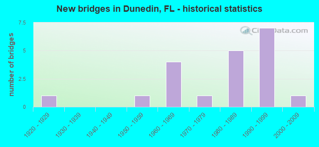
- New bridges - historical statistics
- 11920-1929
- 11950-1959
- 41960-1969
- 11970-1979
- 51980-1989
- 71990-1999
- 12000-2009


- Bridge Condition - Deck
- 75.0%Good
- 12.5%Satisfactory
- 12.5%Fair

- Bridge Condition - Superstructure
- 66.7%Good
- 22.2%Satisfactory
- 11.1%Fair

- Bridge Condition - Substructure
- 22.2%Very good
- 55.6%Good
- 22.2%Satisfactory

- Bridge Condition - Channel
- 11.1%Excellent
- 50.0%Good
- 33.3%Satisfactory
- 5.6%Fair

- Bridge Condition - Culverts
- 55.6%Good
- 33.3%Satisfactory
- 11.1%Fair
Find on map >> Show street view
Structure Number: 150045, Location: 1.0 MI SOUTH OF CR-1 (Lat: 28.035853, Lng: -82.785367), Route carried "on" structure: Alternate US 19, Year Built: 1958, Status: Open, Structure Length: 1.34m (4.40ft), Average Daily Traffic: 16,000 (year 2020), Truck Traffic: 3%, Average Future Daily Traffic: 27,760 (year 2042), Features Intersected: CEDAR CREEK
Minimum Vertical Clearance: 30+ m (98+ ft), Kilometerpoint: 7.921, Lanes on structure: 2, Owner: State Highway Agency, Approaching Roadway Width: 12.1m (39.7ft), Skew: 1 degrees, Material/Design: Concrete, Design/Construction: Culvert, Number Of Spans In Main Unit: 4, Length of Maximum Span: 3.1m (10.2ft), Curb or Sidewalk Widths: Left: 2.4m (7.9ft), Right: 2.4m (7.9ft), Curb-To-Curb Width: 12.1m (39.7ft), Out-to-Out Width: 18.3m (60.0ft)
Condition: Channel: Good, Culverts: Fair, Operating Rating: 60.8 metric tons, Method Used To Determine Operating Rating: Load Factor (LF), Inventory Rating: 36.3 metric tons, Method Used To Determine Inventory Rating: Load Factor (LF), Structural Evaluation: Somewhat better than minimum adequacy, Deck Geometry: Somewhat better than minimum adequacy, Waterway Adequacy: Better than present minimum criteria, Approach Roadway Alignment: Better than present minimum criteria, Designated Inspection Frequency: Every 24 months, Inspection Date: March 2020, Deck Structure Type: Concrete Cast-file-Place
Find on map >> Show street view
Structure Number: 150046, Location: 0.4 MI. SOUTH OF CR-1 (Lat: 28.044500, Lng: -82.782139), Route carried "on" structure: Alternate US 19, Year Built: 1923, Year Reconstructed: 1958, Status: Open, Structure Length: 7.13m (23.39ft), Average Daily Traffic: 19,900 (year 2020), Truck Traffic: 4%, Average Future Daily Traffic: 34,526 (year 2042), Features Intersected: CURLEW CREEK
Minimum Vertical Clearance: 30+ m (98+ ft), Kilometerpoint: 8.895, Lanes on structure: 2, Owner: State Highway Agency, Approaching Roadway Width: 9.3m (30.5ft), Material/Design: Concrete, Design/Construction: Arch - Deck, Number Of Spans In Main Unit: 6, Length of Maximum Span: 11.9m (39.0ft), Curb-To-Curb Width: 8.6m (28.2ft), Out-to-Out Width: 10.6m (34.8ft)
Condition: Deck: Good, Superstructure: Fair, Substructure: Good, Channel: Good, Operating Rating: 35.3 metric tons, Method Used To Determine Operating Rating: Load and Resistance Factor (LRFR), Inventory Rating: 27.2 metric tons, Method Used To Determine Inventory Rating: Load and Resistance Factor (LRFR), Structural Evaluation: Somewhat better than minimum adequacy, Deck Geometry: Meets minimum limits, Waterway Adequacy: Equal to present desirable criteria, Approach Roadway Alignment: Equal to present desirable criteria, Designated Inspection Frequency: Every 24 months, Underwater Inspection Frequency: Every 24 months, Inspection Date: March 2020, Underwater Inspection Date: Febuary 2020, Deck Structure Type: Concrete Cast-file-Place, Wearing Surface/Protective System: Wearing Surface: Bituminous
Find on map >> Show street view
Structure Number: 150067, Location: 2.1MI WEST OF ALT US-19 (Lat: 28.059419, Lng: -82.811511), Route carried "on" structure: County highway 586, Year Built: 1963, Status: Open, Structure Length: 11.77m (38.62ft), Average Daily Traffic: 9,300 (year 2020), Truck Traffic: 4%, Average Future Daily Traffic: 16,136 (year 2042), Features Intersected: ST. JOSEPH SOUND
Minimum Vertical Clearance: 30+ m (98+ ft), Kilometerpoint: 1.197, Lanes on structure: 2, Owner: County Highway Agency, Approaching Roadway Width: 7.9m (25.9ft), Skew: 5 degrees, Material/Design: Prestressed concrete, Design/Construction: Stringer/Multi-beam, Number Of Spans In Main Unit: 8, Length of Maximum Span: 14.9m (48.9ft), Curb or Sidewalk Widths: Left: 1.1m (3.6ft), Right: 1.8m (5.9ft), Curb-To-Curb Width: 7.9m (25.9ft), Out-to-Out Width: 12.1m (39.7ft)
Condition: Deck: Satisfactory, Superstructure: Satisfactory, Substructure: Satisfactory, Channel: Good, Operating Rating: 57.4 metric tons, Method Used To Determine Operating Rating: Load Factor (LF), Inventory Rating: 34.5 metric tons, Method Used To Determine Inventory Rating: Load Factor (LF), Structural Evaluation: Equal to present minimum criteria, Deck Geometry: High priority of corrective action, Waterway Adequacy: Equal to present desirable criteria, Approach Roadway Alignment: Equal to present desirable criteria, Designated Inspection Frequency: Every 24 months, Underwater Inspection Frequency: Every 24 months, Inspection Date: September 2021, Underwater Inspection Date: August 2021, Deck Structure Type: Concrete Cast-file-Place
Find on map >> Show street view
Structure Number: 150068, Location: 1.5MI W OF ALT US 19 (Lat: 28.051092, Lng: -82.795414), Route carried "on" structure: County highway 586, Year Built: 1963, Status: Open, Structure Length: 36.28m (119.03ft), Average Daily Traffic: 9,300 (year 2021), Truck Traffic: 3%, Average Future Daily Traffic: 11,625 (year 2041), Design Load: H 20, Features Intersected: ST. JOSEPH SOUND (ICWW), Facility Carried by Structure: CAUSEWAY BLVD.
Minimum Vertical Clearance: 5.27m (17.29ft), Kilometerpoint: 2.976, Lanes on structure: 2, Owner: County Highway Agency, Approaching Roadway Width: 8.0m (26.2ft), Navigation Control: Yes ( Vertical Clearance: 7.9m (25.9ft), Horizontal Clearance: 27.7m (90.9ft)), Material/Design: Steel, Design/Construction: Movable - Bascule, Number Of Spans In Main Unit: 1, Number Of Approach Spans: 22, Length of Maximum Span: 40.5m (132.9ft), Curb or Sidewalk Widths: Left: 1.1m (3.6ft), Right: 1.8m (5.9ft), Curb-To-Curb Width: 7.9m (25.9ft), Out-to-Out Width: 12.1m (39.7ft)
Condition: Deck: Fair, Superstructure: Satisfactory, Substructure: Satisfactory, Channel: Good, Operating Rating: 44.5 metric tons, Method Used To Determine Operating Rating: Load Factor (LF), Inventory Rating: 26.7 metric tons, Method Used To Determine Inventory Rating: Load Factor (LF), Structural Evaluation: Equal to present minimum criteria, Deck Geometry: High priority of corrective action, Waterway Adequacy: Equal to present minimum criteria, Approach Roadway Alignment: Equal to present desirable criteria, Designated Inspection Frequency: Every 24 months, Critical Feature Inspection Frequency: Every 12 months, Underwater Inspection Frequency: Every 24 months, Other Special Inspection Frequency: Every 12 months, Inspection Date: July 2021, Critical Feature Inspection Date: July 2021, Underwater Inspection Date: June 2021, Other Special Inspection Date: July 2021, Deck Structure Type: Concrete Cast-file-Place
Find on map >> Show street view
Structure Number: 154005, Location: 0.3MI WEST OF US-19A (Lat: 28.050889, Lng: -82.785139), Route carried "on" structure: County highway 586, Year Built: 1994, Status: Open, Structure Length: 3.05m (10.01ft), Average Daily Traffic: 9,300 (year 2020), Truck Traffic: 4%, Average Future Daily Traffic: 16,136 (year 2042), Design Load: HS 20, Features Intersected: ST. JOSEPH SOUND
Minimum Vertical Clearance: 30+ m (98+ ft), Kilometerpoint: 4.147, Lanes on structure: 4, Owner: County Highway Agency, Approaching Roadway Width: 19.5m (64.0ft), Skew: 20 degrees, Material/Design: Prestressed concrete, Design/Construction: Slab, Number Of Spans In Main Unit: 3, Length of Maximum Span: 10.1m (33.1ft), Curb or Sidewalk Widths: Left: 1.6m (5.2ft), Right: 1.6m (5.2ft), Curb-To-Curb Width: 21.4m (70.2ft), Out-to-Out Width: 26.0m (85.3ft)
Condition: Deck: Good, Superstructure: Good, Substructure: Good, Channel: Excellent, Inventory Rating: 77.7 metric tons, Method Used To Determine Inventory Rating: Load Factor (LF), Structural Evaluation: Better than present minimum criteria, Deck Geometry: Superior to present desirable criteria, Waterway Adequacy: Superior to present desirable criteria, Approach Roadway Alignment: Equal to present desirable criteria, Designated Inspection Frequency: Every 24 months, Underwater Inspection Frequency: Every 24 months, Inspection Date: September 2021, Underwater Inspection Date: August 2021, Deck Structure Type: Concrete Precast Panels
Find on map >> Show street view
Structure Number: 154104, Location: 0.5 MI S OF CURLEW RD (Lat: 28.040572, Lng: -82.747050), Route carried "on" structure: County highway , Year Built: 1965, Status: Open, Structure Length: 0.92m (3.02ft), Average Daily Traffic: 22,000 (year 2020), Truck Traffic: 4%, Average Future Daily Traffic: 38,170 (year 2042), Design Load: HS 20, Features Intersected: CURLEW CREEK, Facility Carried by Structure: BELCHER RD.
Minimum Vertical Clearance: 30+ m (98+ ft), Kilometerpoint: 5.938, Lanes on structure: 4, Owner: County Highway Agency, Approaching Roadway Width: 16.7m (54.8ft), Skew: 15 degrees, Material/Design: Concrete, Design/Construction: Culvert, Number Of Spans In Main Unit: 3, Length of Maximum Span: 3.0m (9.8ft)
Condition: Channel: Fair, Culverts: Good, Structural Evaluation: Better than present minimum criteria, Waterway Adequacy: Better than present minimum criteria, Approach Roadway Alignment: Equal to present desirable criteria, Designated Inspection Frequency: Every 24 months, Inspection Date: September 2021
Find on map >> Show street view
Structure Number: 154111, Location: 0.1 MI S OF CURLEW ROAD (Lat: 28.047164, Lng: -82.759533), Route carried "on" structure: County highway 1, Year Built: 1986, Status: Open, Structure Length: 3.72m (12.20ft), Average Daily Traffic: 21,500 (year 2020), Truck Traffic: 4%, Average Future Daily Traffic: 37,303 (year 2042), Design Load: HS 20, Features Intersected: CURLEW CREEK
Minimum Vertical Clearance: 30+ m (98+ ft), Kilometerpoint: 3.098, Lanes on structure: 4, Owner: County Highway Agency, Approaching Roadway Width: 18.3m (60.0ft), Skew: 23 degrees, Material/Design: Prestressed concrete, Design/Construction: Stringer/Multi-beam, Number Of Spans In Main Unit: 2, Length of Maximum Span: 18.6m (61.0ft), Curb or Sidewalk Widths: Left: 2.0m (6.6ft), Right: 2.0m (6.6ft), Curb-To-Curb Width: 18.6m (61.0ft), Out-to-Out Width: 28.1m (92.2ft)
Condition: Deck: Good, Superstructure: Good, Substructure: Good, Channel: Good, Operating Rating: 39.4 metric tons, Method Used To Determine Operating Rating: Load Factor (LF), Inventory Rating: 33.7 metric tons, Method Used To Determine Inventory Rating: Load Factor (LF), Structural Evaluation: Better than present minimum criteria, Deck Geometry: Equal to present minimum criteria, Waterway Adequacy: Equal to present desirable criteria, Approach Roadway Alignment: Equal to present desirable criteria, Designated Inspection Frequency: Every 24 months, Underwater Inspection Frequency: Every 24 months, Inspection Date: September 2021, Underwater Inspection Date: August 2021, Deck Structure Type: Concrete Cast-file-Place
Find on map >> Show street view
Structure Number: 154152, Location: 150FT E OF US-19 (Lat: 28.032258, Lng: -82.737794), Route carried "on" structure: County highway , Year Built: 1973, Status: Open, Structure Length: 0.82m (2.69ft), Average Daily Traffic: 1,000 (year 2021), Truck Traffic: 2%, Average Future Daily Traffic: 1,735 (year 2042), Features Intersected: CURLEW CREEK, Facility Carried by Structure: WINDING CRK BLVD
Minimum Vertical Clearance: 30+ m (98+ ft), Kilometerpoint: 0.000, Lanes on structure: 2, Owner: County Highway Agency, Approaching Roadway Width: 12.2m (40.0ft), Material/Design: Concrete, Design/Construction: Culvert, Number Of Spans In Main Unit: 4, Length of Maximum Span: 1.4m (4.6ft)
Condition: Channel: Satisfactory, Culverts: Good, Structural Evaluation: Better than present minimum criteria, Waterway Adequacy: Better than present minimum criteria, Approach Roadway Alignment: Equal to present desirable criteria, Designated Inspection Frequency: Every 24 months, Inspection Date: September 2021
Find on map >> Show street view
Structure Number: 15419, Location: 0.3 MI W OF PATRICIA AVE (Lat: 27.997361, Lng: -82.779278), Route carried "on" structure: County highway , Year Built: 1965, Status: Open, Structure Length: 0.76m (2.49ft), Average Daily Traffic: 1,550 (year 2020), Truck Traffic: 4%, Average Future Daily Traffic: 2,689 (year 2042), Features Intersected: BRANCH OF STEVENSON CR, Facility Carried by Structure: UNION STREET
Minimum Vertical Clearance: 30+ m (98+ ft), Kilometerpoint: 1.477, Lanes on structure: 2, Owner: County Highway Agency, Approaching Roadway Width: 7.3m (24.0ft), Skew: 3 degrees, Material/Design: Concrete, Design/Construction: Culvert, Number Of Spans In Main Unit: 2, Length of Maximum Span: 3.7m (12.1ft)
Condition: Channel: Satisfactory, Culverts: Good, Operating Rating: 80.6 metric tons, Method Used To Determine Operating Rating: Load Factor (LF), Inventory Rating: 48.4 metric tons, Method Used To Determine Inventory Rating: Load Factor (LF), Structural Evaluation: Better than present minimum criteria, Waterway Adequacy: Equal to present desirable criteria, Approach Roadway Alignment: Equal to present desirable criteria, Designated Inspection Frequency: Every 24 months, Inspection Date: September 2021
Find on map >> Show street view
Structure Number: 155701, Location: 0.25 Mi E of CR-1 (Lat: 28.043831, Lng: -82.755917), Route carried "on" structure: City street , Year Built: 1986, Status: Open, Structure Length: 1.77m (5.81ft), Average Daily Traffic: 400 (year 2020), Truck Traffic: 4%, Average Future Daily Traffic: 694 (year 2042), Design Load: HS 20, Features Intersected: CURLEW CREEK, Facility Carried by Structure: OAK CREEK DRIVE
Minimum Vertical Clearance: 30+ m (98+ ft), Kilometerpoint: 0.423, Lanes on structure: 2, Owner: City or Municipal Highway Agency, Approaching Roadway Width: 8.8m (28.9ft), Material/Design: Prestressed concrete, Design/Construction: Slab, Number Of Spans In Main Unit: 2, Length of Maximum Span: 8.8m (28.9ft), Curb or Sidewalk Widths: Left: 0.5m (1.6ft), Right: 1.6m (5.2ft), Curb-To-Curb Width: 8.6m (28.2ft), Out-to-Out Width: 11.1m (36.4ft)
Condition: Deck: Good, Superstructure: Good, Substructure: Very good, Channel: Good, Operating Rating: 47.8 metric tons, Method Used To Determine Operating Rating: Load Factor (LF), Inventory Rating: 40.2 metric tons, Method Used To Determine Inventory Rating: Load Factor (LF), Structural Evaluation: Better than present minimum criteria, Deck Geometry: Equal to present minimum criteria, Waterway Adequacy: Better than present minimum criteria, Approach Roadway Alignment: Better than present minimum criteria, Designated Inspection Frequency: Every 24 months, Inspection Date: November 2021, Deck Structure Type: Concrete Precast Panels, Wearing Surface/Protective System: Wearing Surface: Bituminous
Find on map >> Show street view
Structure Number: 155702, Location: 71FT N OF OAK CRK DR (Lat: 28.044361, Lng: -82.755306), Route carried "on" structure: City street , Year Built: 1986, Status: Open, Structure Length: 2.01m (6.59ft), Average Daily Traffic: 110 (year 2021), Truck Traffic: 1%, Average Future Daily Traffic: 191 (year 2042), Design Load: HS 20, Features Intersected: CURLEW CREEK, Facility Carried by Structure: CROSS CREEK WAY
Minimum Vertical Clearance: 30+ m (98+ ft), Kilometerpoint: 0.000, Lanes on structure: 2, Owner: City or Municipal Highway Agency, Approaching Roadway Width: 8.0m (26.2ft), Skew: 3 degrees, Material/Design: Prestressed concrete, Design/Construction: Slab, Number Of Spans In Main Unit: 2, Length of Maximum Span: 10.0m (32.8ft), Curb or Sidewalk Widths: Left: 0.5m (1.6ft), Right: 1.6m (5.2ft), Curb-To-Curb Width: 8.6m (28.2ft), Out-to-Out Width: 11.2m (36.7ft)
Condition: Deck: Good, Superstructure: Good, Substructure: Very good, Channel: Good, Operating Rating: 47.2 metric tons, Method Used To Determine Operating Rating: Load Factor (LF), Inventory Rating: 38.4 metric tons, Method Used To Determine Inventory Rating: Load Factor (LF), Structural Evaluation: Better than present minimum criteria, Deck Geometry: Equal to present minimum criteria, Waterway Adequacy: Equal to present desirable criteria, Approach Roadway Alignment: Equal to present desirable criteria, Designated Inspection Frequency: Every 24 months, Inspection Date: November 2021, Deck Structure Type: Concrete Precast Panels, Wearing Surface/Protective System: Wearing Surface: Bituminous
Find on map >> Show street view
Structure Number: 155703, Location: 0.3MI W OF BELCHER RD (Lat: 28.044047, Lng: -82.751225), Route carried "on" structure: City street , Year Built: 1986, Status: Open, Structure Length: 1.89m (6.20ft), Average Daily Traffic: 400 (year 2020), Truck Traffic: 4%, Average Future Daily Traffic: 694 (year 2042), Design Load: HS 20, Features Intersected: CURLEW CREEK, Facility Carried by Structure: SADDLE HILL ROAD
Minimum Vertical Clearance: 30+ m (98+ ft), Kilometerpoint: 0.930, Lanes on structure: 2, Owner: City or Municipal Highway Agency, Approaching Roadway Width: 8.6m (28.2ft), Material/Design: Prestressed concrete, Design/Construction: Slab, Number Of Spans In Main Unit: 2, Length of Maximum Span: 9.4m (30.8ft), Curb or Sidewalk Widths: Left: 0.5m (1.6ft), Right: 1.6m (5.2ft), Curb-To-Curb Width: 8.6m (28.2ft), Out-to-Out Width: 11.3m (37.1ft)
Condition: Deck: Good, Superstructure: Good, Substructure: Good, Channel: Satisfactory, Operating Rating: 47.7 metric tons, Method Used To Determine Operating Rating: Load Factor (LF), Inventory Rating: 41.1 metric tons, Method Used To Determine Inventory Rating: Load Factor (LF), Structural Evaluation: Better than present minimum criteria, Deck Geometry: Equal to present minimum criteria, Waterway Adequacy: Better than present minimum criteria, Approach Roadway Alignment: Better than present minimum criteria, Designated Inspection Frequency: Every 24 months, Inspection Date: November 2021, Deck Structure Type: Concrete Precast Panels, Wearing Surface/Protective System: Wearing Surface: Bituminous
Find on map >> Show street view
Structure Number: 155704, Location: 0.16 MI. W of CR-97 Ext (Lat: 28.038111, Lng: -82.753861), Route carried "on" structure: City street , Year Built: 1988, Status: Open, Structure Length: 0.84m (2.76ft), Average Daily Traffic: 60 (year 2021), Truck Traffic: 1%, Average Future Daily Traffic: 104 (year 2042), Design Load: HS 20, Features Intersected: INDIAN CREEK, Facility Carried by Structure: INDIAN CK COURT
Minimum Vertical Clearance: 30+ m (98+ ft), Kilometerpoint: 0.000, Lanes on structure: 2, Owner: City or Municipal Highway Agency, Approaching Roadway Width: 7.3m (24.0ft), Skew: 3 degrees, Material/Design: Concrete, Design/Construction: Culvert, Number Of Spans In Main Unit: 3, Length of Maximum Span: 2.3m (7.5ft), Curb or Sidewalk Widths: Left: 1.5m (4.9ft), Right: 1.5m (4.9ft)
Condition: Channel: Satisfactory, Culverts: Satisfactory, Operating Rating: 24.1 metric tons, Method Used To Determine Operating Rating: Load Factor (LF), Inventory Rating: 14.3 metric tons, Method Used To Determine Inventory Rating: Load Factor (LF), Structural Evaluation: Meets minimum limits, Waterway Adequacy: Equal to present minimum criteria, Approach Roadway Alignment: Equal to present desirable criteria, Designated Inspection Frequency: Every 24 months, Inspection Date: November 2021
Find on map >> Show street view
Structure Number: 155705, Location: 0.1MI W/O DINNERBELL LN (Lat: 28.026319, Lng: -82.753144), Route carried "on" structure: City street , Year Built: 1991, Status: Open, Structure Length: 0.69m (2.26ft), Average Daily Traffic: 386 (year 2020), Truck Traffic: 1%, Average Future Daily Traffic: 670 (year 2042), Design Load: HS 20, Features Intersected: RANCHWOOD CANAL, Facility Carried by Structure: COPPER KETTLE LANE
Minimum Vertical Clearance: 30+ m (98+ ft), Kilometerpoint: 0.000, Lanes on structure: 2, Owner: City or Municipal Highway Agency, Approaching Roadway Width: 8.7m (28.5ft), Skew: 2 degrees, Material/Design: Concrete, Design/Construction: Culvert, Number Of Spans In Main Unit: 2, Length of Maximum Span: 3.1m (10.2ft), Curb or Sidewalk Widths: Left: 4.0m (13.1ft), Right: 2.7m (8.9ft)
Condition: Channel: Satisfactory, Culverts: Good, Operating Rating: 71.8 metric tons, Method Used To Determine Operating Rating: Load Factor (LF), Inventory Rating: 43.1 metric tons, Method Used To Determine Inventory Rating: Load Factor (LF), Structural Evaluation: Better than present minimum criteria, Waterway Adequacy: Equal to present minimum criteria, Approach Roadway Alignment: Equal to present desirable criteria, Designated Inspection Frequency: Every 24 months, Inspection Date: November 2021
Find on map >> Show street view
Structure Number: 155706, Location: 0.1MI WOF DINNERBELL LANE (Lat: 28.027081, Lng: -82.753358), Route carried "on" structure: City street , Year Built: 1991, Status: Open, Structure Length: 0.66m (2.17ft), Average Daily Traffic: 272 (year 2021), Truck Traffic: 1%, Average Future Daily Traffic: 472 (year 2042), Design Load: HS 20, Features Intersected: RANCHWOOD CANAL, Facility Carried by Structure: TEAKWOOD LN
Minimum Vertical Clearance: 30+ m (98+ ft), Kilometerpoint: 0.000, Lanes on structure: 2, Owner: City or Municipal Highway Agency, Approaching Roadway Width: 6.0m (19.7ft), Material/Design: Concrete, Design/Construction: Culvert, Number Of Spans In Main Unit: 2, Length of Maximum Span: 3.1m (10.2ft), Curb or Sidewalk Widths: Left: 1.9m (6.2ft), Right: 2.3m (7.5ft)
Condition: Channel: Good, Culverts: Satisfactory, Operating Rating: 67.9 metric tons, Method Used To Determine Operating Rating: Load Factor (LF), Inventory Rating: 40.8 metric tons, Method Used To Determine Inventory Rating: Load Factor (LF), Structural Evaluation: Equal to present minimum criteria, Waterway Adequacy: Equal to present minimum criteria, Approach Roadway Alignment: Equal to present desirable criteria, Designated Inspection Frequency: Every 24 months, Inspection Date: November 2021
Find on map >> Show street view
Structure Number: 155707, Location: 0.4MI W OF BELCHER RD (Lat: 28.030381, Lng: -82.753328), Route carried "on" structure: City street , Year Built: 1991, Status: Open, Structure Length: 1.03m (3.38ft), Average Daily Traffic: 3,500 (year 2020), Truck Traffic: 3%, Average Future Daily Traffic: 6,072 (year 2042), Design Load: HS 20, Features Intersected: RANCHWOOD CANAL, Facility Carried by Structure: SOLON AVENUE
Minimum Vertical Clearance: 30+ m (98+ ft), Kilometerpoint: 0.859, Lanes on structure: 2, Owner: City or Municipal Highway Agency, Approaching Roadway Width: 7.3m (24.0ft), Material/Design: Concrete, Design/Construction: Culvert, Number Of Spans In Main Unit: 3, Length of Maximum Span: 3.0m (9.8ft), Curb or Sidewalk Widths: Left: 2.1m (6.9ft), Right: 2.1m (6.9ft)
Condition: Channel: Satisfactory, Culverts: Satisfactory, Operating Rating: 70.5 metric tons, Method Used To Determine Operating Rating: Load Factor (LF), Inventory Rating: 42.3 metric tons, Method Used To Determine Inventory Rating: Load Factor (LF), Structural Evaluation: Equal to present minimum criteria, Waterway Adequacy: Equal to present minimum criteria, Approach Roadway Alignment: Equal to present desirable criteria, Designated Inspection Frequency: Every 24 months, Inspection Date: November 2021
Find on map >> Show street view
Structure Number: 155708, Location: 0.3MI W OF BELCHER RD (Lat: 28.033250, Lng: -82.752667), Route carried "on" structure: City street , Year Built: 1991, Status: Open, Structure Length: 1.03m (3.38ft), Average Daily Traffic: 464 (year 2021), Truck Traffic: 1%, Average Future Daily Traffic: 805 (year 2042), Design Load: HS 20, Features Intersected: RANCHWOOD CANAL, Facility Carried by Structure: SOURWOOD BLVD
Minimum Vertical Clearance: 30+ m (98+ ft), Kilometerpoint: 0.000, Lanes on structure: 2, Owner: City or Municipal Highway Agency, Approaching Roadway Width: 7.3m (24.0ft), Skew: 1 degrees, Material/Design: Concrete, Design/Construction: Culvert, Number Of Spans In Main Unit: 3, Length of Maximum Span: 3.1m (10.2ft), Curb or Sidewalk Widths: Left: 1.9m (6.2ft), Right: 2.0m (6.6ft)
Condition: Channel: Good, Culverts: Good, Operating Rating: 69.9 metric tons, Method Used To Determine Operating Rating: Load Factor (LF), Inventory Rating: 42.0 metric tons, Method Used To Determine Inventory Rating: Load Factor (LF), Structural Evaluation: Better than present minimum criteria, Waterway Adequacy: Somewhat better than minimum adequacy, Approach Roadway Alignment: Equal to present desirable criteria, Designated Inspection Frequency: Every 24 months, Inspection Date: November 2021
Find on map >> Show street view
Structure Number: 156711, Location: 50FT. E OF NEW YORK AVE. (Lat: 28.000094, Lng: -82.779494), Route carried "on" structure: City street , Year Built: 2003, Status: Open, Structure Length: 0.98m (3.22ft), Average Daily Traffic: 10 (year 2020), Average Future Daily Traffic: 17 (year 2042), Design Load: HS 20, Features Intersected: HARRISON'S CANAL, Facility Carried by Structure: WEST LOT ENTRANCE
Minimum Vertical Clearance: 30.45m (99.90ft), Kilometerpoint: 0.000, Lanes on structure: 2, Owner: Local Agency, Approaching Roadway Width: 8.5m (27.9ft), Material/Design: Concrete, Design/Construction: Arch - Deck, Number Of Spans In Main Unit: 1, Length of Maximum Span: 9.8m (32.2ft), Curb or Sidewalk Widths: Left: 0.0m, Right: 1.7m (5.6ft), Curb-To-Curb Width: 8.5m (27.9ft), Out-to-Out Width: 14.6m (47.9ft)
Condition: Superstructure: Good, Substructure: Good, Channel: Excellent, Operating Rating: 56.6 metric tons, Method Used To Determine Operating Rating: Load and Resistance Factor (LRFR), Inventory Rating: 43.6 metric tons, Method Used To Determine Inventory Rating: Load and Resistance Factor (LRFR), Structural Evaluation: Better than present minimum criteria, Deck Geometry: Better than present minimum criteria, Waterway Adequacy: Equal to present desirable criteria, Approach Roadway Alignment: Equal to present desirable criteria, Designated Inspection Frequency: Every 24 months, Inspection Date: August 2020
Find on map >> Show street view
Structure Number: 154102, Location: 0.5MI NORTH OF SR-586 (Lat: 28.055000, Lng: -82.777083), Route carried "under" structure: US 19A, Year Built: 1994, Structure Length: 0. m, Average Daily Traffic: 14,600 (year 2020), Truck Traffic: 4%, Features Intersected: ALT US-19/PALM HARBOR BL, Facility Carried by Structure: PINELLAS TRAIL
Minimum Vertical Clearance: 5.61m (18.41ft), Kilometerpoint: 10.203, Lanes under structure: 4, Material/Design: Steel, Design/Construction: Truss - Thru, Length of Maximum Span: 44.4m (145.7ft)
Find on map >> Show street view
Structure Number: 154102, Location: 0.5MI NORTH OF SR-586 (Lat: 28.055000, Lng: -82.777083), Route carried "under" structure: County highway , Year Built: 1994, Structure Length: 0. m, Average Daily Traffic: 1,250 (year 2020), Truck Traffic: 4%, Features Intersected: ALT US-19/PALM HARBOR BL, Facility Carried by Structure: PINELLAS TRAIL
Minimum Vertical Clearance: 6.28m (20.60ft), Kilometerpoint: 0.027, Lanes under structure: 2, Material/Design: Steel, Design/Construction: Truss - Thru, Length of Maximum Span: 44.4m (145.7ft)