Bridge Statistics for Dumbarton, Virginia (VA)
Condition, Traffic, Stress, Structural Evaluation, Project Costs
- National Bridge Inventory (NBI) Statistics
- 29Number of bridges
- 364ft / 111mTotal length
- $2,725,000Total costs
- 1,305,023Total average daily traffic
- 35,633Total average daily truck traffic
- National Bridge Inventory (NBI) Registered Bridges for Dumbarton
- No street view available for this location
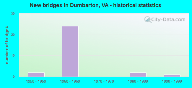
- New bridges - historical statistics
- 21950-1959
- 241960-1969
- 21980-1989
- 11990-1999

- Reconstructed bridges - Historical Statistics
- 11980-1989
- 01990-1999
- 32000-2009


- Bridge Condition - Deck
- 20.0%Good
- 60.0%Satisfactory
- 20.0%Fair

- Bridge Condition - Superstructure
- 20.0%Good
- 20.0%Satisfactory
- 60.0%Fair

- Bridge Condition - Substructure
- 10.0%Good
- 30.0%Satisfactory
- 40.0%Fair
- 20.0%Poor

- Bridge Condition - Channel
- 10.0%Good
- 70.0%Satisfactory
- 20.0%Fair

- Bridge Condition - Culverts
- 10.0%Very good
- 40.0%Satisfactory
- 50.0%Fair
Find on map >> Show street view
Structure Number: 9604, Location: .41frDickens/.45toGlensid (Lat: 37.604719, Lng: -77.508589), Route carried "on" structure: County highway 7647, Year Built: 1967, Status: Posted for load, Structure Length: 8.30m (27.23ft), Average Daily Traffic: 4,117 (year 2020), Truck Traffic: 2%, Average Future Daily Traffic: 4,529 (year 2040), Design Load: HS 20+Mod, Features Intersected: RTE I 64, Facility Carried by Structure: BETHLEHEM ROAD
Minimum Vertical Clearance: 30+ m (98+ ft), Kilometerpoint: 4.716, Lanes on structure: 2, Lanes under structure: 7, Owner: State Highway Agency, Approaching Roadway Width: 8.5m (27.9ft), Skew: 2 degrees, Material/Design: Prestressed concrete, Design/Construction: Stringer/Multi-beam, Number Of Spans In Main Unit: 4, Length of Maximum Span: 24.8m (81.4ft), Curb or Sidewalk Widths: Left: 1.5m (4.9ft), Right: 1.5m (4.9ft), Curb-To-Curb Width: 8.5m (27.9ft), Out-to-Out Width: 12.2m (40.0ft)
Condition: Deck: Fair, Superstructure: Fair, Substructure: Poor, Operating Rating: 87.1 metric tons, Method Used To Determine Operating Rating: Load and Resistance Factor (LRFR), Inventory Rating: 38.1 metric tons, Method Used To Determine Inventory Rating: Load and Resistance Factor (LRFR), Structural Evaluation: Meets minimum limits, Deck Geometry: Meets minimum limits, Underclear: Equal to present minimum criteria, Approach Roadway Alignment: Equal to present desirable criteria, Designated Inspection Frequency: Every 24 months, Other Special Inspection Frequency: Every 12 months, Inspection Date: October 2020, Other Special Inspection Date: October 2021, Deck Structure Type: Concrete Cast-file-Place
Find on map >> Show street view
Structure Number: 9606, Location: 0.20BETHLEHEM & 0.55 TO33 (Lat: 37.601542, Lng: -77.500708), Route carried "on" structure: County highway 7546, Year Built: 1967, Status: Open, Structure Length: 8.51m (27.92ft), Average Daily Traffic: 5,919 (year 2020), Truck Traffic: 2%, Average Future Daily Traffic: 6,659 (year 2040), Design Load: HS 20+Mod, Features Intersected: ROUTE 0064, Facility Carried by Structure: DICKENS ROAD
Minimum Vertical Clearance: 30+ m (98+ ft), Kilometerpoint: 1.207, Lanes on structure: 4, Lanes under structure: 6, Owner: State Highway Agency, Approaching Roadway Width: 14.6m (47.9ft), Skew: 1 degrees, Material/Design: Prestressed concrete, Design/Construction: Stringer/Multi-beam, Number Of Spans In Main Unit: 4, Length of Maximum Span: 22.2m (72.8ft), Curb or Sidewalk Widths: Left: 1.7m (5.6ft), Right: 1.7m (5.6ft), Curb-To-Curb Width: 14.6m (47.9ft), Out-to-Out Width: 18.6m (61.0ft)
Condition: Deck: Satisfactory, Superstructure: Fair, Substructure: Poor, Operating Rating: 77.7 metric tons, Method Used To Determine Operating Rating: Load and Resistance Factor (LRFR), Inventory Rating: 43.1 metric tons, Method Used To Determine Inventory Rating: Load and Resistance Factor (LRFR), Structural Evaluation: Meets minimum limits, Deck Geometry: High priority of replacement, Underclear: Somewhat better than minimum adequacy, Approach Roadway Alignment: Equal to present desirable criteria, Designated Inspection Frequency: Every 24 months, Other Special Inspection Frequency: Every 12 months, Inspection Date: October 2020, Other Special Inspection Date: October 2021, Deck Structure Type: Concrete Cast-file-Place
Find on map >> Show street view
Structure Number: 961, Location: .35frForest & .28 to 250 (Lat: 37.605864, Lng: -77.522322), Route carried "on" structure: County highway 7536, Year Built: 1967, Status: Open, Structure Length: 12.21m (40.06ft), Average Daily Traffic: 22,237 (year 2020), Truck Traffic: 1%, Average Future Daily Traffic: 24,461 (year 2040), Design Load: HS 20+Mod, Features Intersected: ROUTE I-64, Facility Carried by Structure: GLENSIDE DRIVE
Minimum Vertical Clearance: 30+ m (98+ ft), Kilometerpoint: 1.609, Lanes on structure: 5, Lanes under structure: 8, Base Highway Network: Yes, Owner: State Highway Agency, Approaching Roadway Width: 22.6m (74.1ft), Skew: 24 degrees, Material/Design: Steel, Design/Construction: Stringer/Multi-beam, Number Of Spans In Main Unit: 5, Length of Maximum Span: 32.3m (106.0ft), Curb or Sidewalk Widths: Left: 0.2m (0.7ft), Right: 0.5m (1.6ft), Curb-To-Curb Width: 22.6m (74.1ft), Out-to-Out Width: 28.2m (92.5ft)
Condition: Deck: Satisfactory, Superstructure: Fair, Substructure: Satisfactory, Operating Rating: 51.7 metric tons, Method Used To Determine Operating Rating: Load and Resistance Factor (LRFR), Inventory Rating: 39.9 metric tons, Method Used To Determine Inventory Rating: Load and Resistance Factor (LRFR), Structural Evaluation: Somewhat better than minimum adequacy, Deck Geometry: Equal to present minimum criteria, Underclear: Meets minimum limits, Approach Roadway Alignment: Equal to present desirable criteria, Length Of Structure Improvement: 12.22m (40.09ft), Designated Inspection Frequency: Every 24 months, Inspection Date: August 2021, Bridge Improvement Cost: $800,000, Roadway Improvement Cost: $100,000, Total Project Cost: $905,000, Deck Structure Type: Concrete Cast-file-Place, Wearing Surface/Protective System: Wearing Surface: Monolithic Concrete
Find on map >> Show street view
Structure Number: 9642, Location: 0.09 FR 33 & 1.25 TO 161 (Lat: 37.603558, Lng: -77.490200), Route carried "on" structure: County highway , Year Built: 1966, Year Reconstructed: 2007, Status: Open, Structure Length: 5.79m (19.00ft), Average Daily Traffic: 13,636 (year 2020), Truck Traffic: 2%, Average Future Daily Traffic: 19,090 (year 2040), Design Load: HS 20, Features Intersected: CSX RAILWAY, Facility Carried by Structure: DUMBARTON ROAD
Minimum Vertical Clearance: 30+ m (98+ ft), Kilometerpoint: 0.145, Lanes on structure: 4, Owner: County Highway Agency, Approaching Roadway Width: 16.5m (54.1ft), Skew: 21 degrees, Material/Design: Steel, Design/Construction: Stringer/Multi-beam, Number Of Spans In Main Unit: 3, Length of Maximum Span: 31.1m (102.0ft), Curb or Sidewalk Widths: Left: 1.5m (4.9ft), Right: 1.5m (4.9ft), Curb-To-Curb Width: 16.5m (54.1ft), Out-to-Out Width: 22.3m (73.2ft)
Condition: Deck: Satisfactory, Superstructure: Satisfactory, Substructure: Satisfactory, Operating Rating: 51.8 metric tons, Method Used To Determine Operating Rating: Load and Resistance Factor (LRFR), Inventory Rating: 39.9 metric tons, Method Used To Determine Inventory Rating: Load and Resistance Factor (LRFR), Structural Evaluation: Equal to present minimum criteria, Deck Geometry: Meets minimum limits, Underclear: Equal to present desirable criteria, Approach Roadway Alignment: Equal to present minimum criteria, Length Of Structure Improvement: 5.79m (19.00ft), Designated Inspection Frequency: Every 24 months, Inspection Date: May 2020, Bridge Improvement Cost: $580,000, Roadway Improvement Cost: $90,000, Total Project Cost: $764,000, Deck Structure Type: Concrete Cast-file-Place, Wearing Surface/Protective System: Wearing Surface: Latex Concrete
Find on map >> Show street view
Structure Number: 9691, Location: .12 LIBBIE & .33 DICKENS (Lat: 37.596908, Lng: -77.499978), Route carried "on" structure: County highway , Year Built: 1990, Status: Posted for load, Structure Length: 1.34m (4.40ft), Average Daily Traffic: 4,549 (year 2020), Truck Traffic: 2%, Average Future Daily Traffic: 5,004 (year 2040), Design Load: HS 20+Mod, Features Intersected: HORSEPEN BRANCH, Facility Carried by Structure: BETHLEHEM ROAD
Minimum Vertical Clearance: 30+ m (98+ ft), Kilometerpoint: 3.443, Lanes on structure: 2, Owner: County Highway Agency, Approaching Roadway Width: 7.9m (25.9ft), Material/Design: Concrete, Design/Construction: Culvert, Number Of Spans In Main Unit: 4, Length of Maximum Span: 3.0m (9.8ft), Curb or Sidewalk Widths: Left: 1.5m (4.9ft), Right: 1.5m (4.9ft), Curb-To-Curb Width: 12.2m (40.0ft), Out-to-Out Width: 15.8m (51.8ft)
Condition: Channel: Satisfactory, Culverts: Satisfactory, Operating Rating: 28.1 metric tons, Method Used To Determine Operating Rating: Field evaluation and documented engineering judgment, Inventory Rating: 16.3 metric tons, Method Used To Determine Inventory Rating: Field evaluation and documented engineering judgment, Structural Evaluation: Meets minimum limits, Deck Geometry: Equal to present minimum criteria, Waterway Adequacy: Somewhat better than minimum adequacy, Approach Roadway Alignment: Equal to present desirable criteria, Bridge Posting: Required (Relationship of Operating Rating to Maximum Legal Load: 0.1 - 9.9% below), Designated Inspection Frequency: Every 24 months, Inspection Date: July 2020, Deck Structure Type: Concrete Cast-file-Place, Wearing Surface/Protective System: Wearing Surface: Bituminous
Find on map >> Show street view
Structure Number: 9699, Location: 0.42 TO GLENSIDE DRIVE (Lat: 37.606486, Lng: -77.509686), Route carried "on" structure: County highway , Year Built: 1967, Status: Open, Structure Length: 1.31m (4.30ft), Average Daily Traffic: 4,117 (year 2020), Truck Traffic: 2%, Average Future Daily Traffic: 4,529 (year 2040), Design Load: HS 20, Features Intersected: UPHAM BROOK, Facility Carried by Structure: BETHLEHEM ROAD
Minimum Vertical Clearance: 30+ m (98+ ft), Kilometerpoint: 4.792, Lanes on structure: 2, Owner: County Highway Agency, Approaching Roadway Width: 7.3m (24.0ft), Skew: 1 degrees, Material/Design: Concrete, Design/Construction: Culvert, Number Of Spans In Main Unit: 4, Length of Maximum Span: 3.0m (9.8ft)
Condition: Channel: Satisfactory, Culverts: Very good, Operating Rating: 89.8 metric tons, Method Used To Determine Operating Rating: Field evaluation and documented engineering judgment, Inventory Rating: 89.8 metric tons, Method Used To Determine Inventory Rating: Field evaluation and documented engineering judgment, Structural Evaluation: Equal to present desirable criteria, Waterway Adequacy: Superior to present desirable criteria, Approach Roadway Alignment: Equal to present desirable criteria, Designated Inspection Frequency: Every 24 months, Inspection Date: April 2020
Find on map >> Show street view
Structure Number: 9736, Location: 0.11 TO WISTAR ROAD (Lat: 37.620889, Lng: -77.501925), Route carried "on" structure: US 33, Year Built: 1956, Year Reconstructed: 1993, Status: Open, Structure Length: 0.70m (2.30ft), Average Daily Traffic: 28,152 (year 2020), Truck Traffic: 2%, Average Future Daily Traffic: 39,071 (year 2040), Design Load: HS 20, Features Intersected: STREAM, Facility Carried by Structure: STAPLES MILL ROAD
Minimum Vertical Clearance: 30+ m (98+ ft), Kilometerpoint: 208.121, Lanes on structure: 6, Base Highway Network: Yes, Owner: State Highway Agency, Approaching Roadway Width: 32.9m (107.9ft), Skew: 21 degrees, Material/Design: Concrete, Design/Construction: Culvert, Number Of Spans In Main Unit: 4, Length of Maximum Span: 1.2m (3.9ft)
Condition: Channel: Satisfactory, Culverts: Satisfactory, Operating Rating: 54.4 metric tons, Method Used To Determine Operating Rating: Field evaluation and documented engineering judgment, Inventory Rating: 32.7 metric tons, Method Used To Determine Inventory Rating: Field evaluation and documented engineering judgment, Structural Evaluation: Equal to present minimum criteria, Waterway Adequacy: Equal to present desirable criteria, Approach Roadway Alignment: Equal to present desirable criteria, Designated Inspection Frequency: Every 24 months, Inspection Date: November 2021
Find on map >> Show street view
Structure Number: 9739, Location: 0.33BETHLEHEM0.28DICKEN R (Lat: 37.597817, Lng: -77.491447), Route carried "on" structure: US 33, Year Built: 1967, Status: Open, Structure Length: 8.27m (27.13ft), Average Daily Traffic: 16,692 (year 2020), Truck Traffic: 2%, Average Future Daily Traffic: 18,361 (year 2040), Design Load: HS 20+Mod, Features Intersected: RTE I 64, Facility Carried by Structure: STAPLES MILL ROAD
Minimum Vertical Clearance: 30+ m (98+ ft), Kilometerpoint: 210.972, Lanes on structure: 6, Lanes under structure: 9, Base Highway Network: Yes, Owner: State Highway Agency, Approaching Roadway Width: 23.8m (78.1ft), Skew: 20 degrees, Material/Design: Prestressed concrete, Design/Construction: Stringer/Multi-beam, Number Of Spans In Main Unit: 4, Length of Maximum Span: 25.6m (84.0ft), Curb or Sidewalk Widths: Left: 1.5m (4.9ft), Right: 1.5m (4.9ft), Curb-To-Curb Width: 23.8m (78.1ft), Out-to-Out Width: 31.7m (104.0ft)
Condition: Deck: Fair, Superstructure: Satisfactory, Substructure: Fair, Operating Rating: 78.0 metric tons, Method Used To Determine Operating Rating: Load and Resistance Factor (LRFR), Inventory Rating: 42.6 metric tons, Method Used To Determine Inventory Rating: Load and Resistance Factor (LRFR), Structural Evaluation: Somewhat better than minimum adequacy, Deck Geometry: Somewhat better than minimum adequacy, Underclear: Somewhat better than minimum adequacy, Approach Roadway Alignment: Equal to present desirable criteria, Designated Inspection Frequency: Every 24 months, Inspection Date: October 2020, Deck Structure Type: Concrete Cast-file-Place
Find on map >> Show street view
Structure Number: 9743, Location: 0.1 I-64 W & .11 DICKENS (Lat: 37.599511, Lng: -77.491147), Route carried "on" structure: US 33, Year Built: 1964, Status: Open, Structure Length: 0.64m (2.10ft), Average Daily Traffic: 16,692 (year 2020), Truck Traffic: 1%, Average Future Daily Traffic: 18,361 (year 2040), Design Load: HS 20, Features Intersected: HORSEPEN BRANCH, Facility Carried by Structure: STAPLES MILL ROAD
Minimum Vertical Clearance: 30+ m (98+ ft), Kilometerpoint: 210.774, Lanes on structure: 5, Base Highway Network: Yes, Owner: State Highway Agency, Approaching Roadway Width: 20.7m (67.9ft), Skew: 20 degrees, Material/Design: Concrete, Design/Construction: Culvert, Number Of Spans In Main Unit: 2, Length of Maximum Span: 3.0m (9.8ft)
Condition: Channel: Satisfactory, Culverts: Fair, Operating Rating: 89.8 metric tons, Method Used To Determine Operating Rating: Field evaluation and documented engineering judgment, Inventory Rating: 89.8 metric tons, Method Used To Determine Inventory Rating: Field evaluation and documented engineering judgment, Structural Evaluation: Somewhat better than minimum adequacy, Waterway Adequacy: Equal to present desirable criteria, Approach Roadway Alignment: Equal to present desirable criteria, Designated Inspection Frequency: Every 24 months, Inspection Date: December 2020
Find on map >> Show street view
Structure Number: 9744, Location: 0.29 TO 64 & 0.94 TO 356 (Lat: 37.601422, Lng: -77.490944), Route carried "on" structure: US 33, Year Built: 1966, Status: Open, Structure Length: 1.34m (4.40ft), Average Daily Traffic: 28,586 (year 2020), Truck Traffic: 2%, Average Future Daily Traffic: 36,920 (year 2040), Design Load: HS 20+Mod, Features Intersected: UPHAM BROOK, Facility Carried by Structure: STAPLES MILL ROAD
Minimum Vertical Clearance: 30+ m (98+ ft), Kilometerpoint: 210.573, Lanes on structure: 7, Base Highway Network: Yes, Owner: State Highway Agency, Approaching Roadway Width: 26.8m (87.9ft), Skew: 24 degrees, Material/Design: Concrete, Design/Construction: Culvert, Number Of Spans In Main Unit: 3, Length of Maximum Span: 4.3m (14.1ft)
Condition: Channel: Satisfactory, Culverts: Fair, Operating Rating: 54.4 metric tons, Method Used To Determine Operating Rating: Field evaluation and documented engineering judgment, Inventory Rating: 32.7 metric tons, Method Used To Determine Inventory Rating: Field evaluation and documented engineering judgment, Structural Evaluation: Somewhat better than minimum adequacy, Waterway Adequacy: Equal to present desirable criteria, Approach Roadway Alignment: Equal to present desirable criteria, Designated Inspection Frequency: Every 24 months, Inspection Date: November 2020
Find on map >> Show street view
Structure Number: 9774, Location: 0.3 TO 64 WBL & 0.1 TO 33 (Lat: 37.598161, Lng: -77.493992), Route carried "on" structure: Ramp Interstate 64, Year Built: 1967, Status: Open, Structure Length: 7.86m (25.79ft), Average Daily Traffic: 10,730 (year 2020), Truck Traffic: 5%, Average Future Daily Traffic: 13,478 (year 2040), Design Load: HS 20+Mod, Features Intersected: I-64
Minimum Vertical Clearance: 30+ m (98+ ft), Kilometerpoint: 0.483, Lanes on structure: 2, Lanes under structure: 7, Base Highway Network: Yes, Owner: State Highway Agency, Approaching Roadway Width: 9.1m (29.9ft), Material/Design: Steel, Design/Construction: Stringer/Multi-beam, Number Of Spans In Main Unit: 4, Length of Maximum Span: 25.7m (84.3ft), Curb or Sidewalk Widths: Left: 0.5m (1.6ft), Right: 0.5m (1.6ft), Curb-To-Curb Width: 9.1m (29.9ft), Out-to-Out Width: 10.7m (35.1ft)
Condition: Deck: Satisfactory, Superstructure: Fair, Substructure: Fair, Operating Rating: 60.8 metric tons, Method Used To Determine Operating Rating: Load and Resistance Factor (LRFR), Inventory Rating: 46.3 metric tons, Method Used To Determine Inventory Rating: Load and Resistance Factor (LRFR), Structural Evaluation: Somewhat better than minimum adequacy, Deck Geometry: Meets minimum limits, Underclear: Somewhat better than minimum adequacy, Approach Roadway Alignment: Equal to present desirable criteria, Length Of Structure Improvement: 7.86m (25.79ft), Designated Inspection Frequency: Every 24 months, Inspection Date: October 2020, Bridge Improvement Cost: $120,000, Roadway Improvement Cost: $1,000, Total Project Cost: $135,000, Deck Structure Type: Concrete Cast-file-Place
Find on map >> Show street view
Structure Number: 9776, Location: 0.4 FR 33 & 0.55 WCL RICH (Lat: 37.596297, Lng: -77.486503), Route carried "on" structure: Interstate 64, Year Built: 1967, Year Reconstructed: 2007, Status: Open, Structure Length: 15.76m (51.71ft), Average Daily Traffic: 59,938 (year 2020), Truck Traffic: 4%, Average Future Daily Traffic: 83,913 (year 2040), Design Load: HS 20+Mod, Features Intersected: CSXT RAILROAD ACCA YARD
Minimum Vertical Clearance: 30+ m (98+ ft), Kilometerpoint: 299.403, Lanes on structure: 5, Base Highway Network: Yes, Owner: State Highway Agency, Approaching Roadway Width: 22.6m (74.1ft), Skew: 9 degrees, Material/Design: Steel continuous, Design/Construction: Stringer/Multi-beam, Number Of Spans In Main Unit: 3, Number Of Approach Spans: 1, Length of Maximum Span: 54.3m (178.1ft), Curb-To-Curb Width: 22.5m (73.8ft), Out-to-Out Width: 23.5m (77.1ft)
Condition: Deck: Good, Superstructure: Good, Substructure: Good, Operating Rating: 94.3 metric tons, Method Used To Determine Operating Rating: Load and Resistance Factor (LRFR), Inventory Rating: 72.6 metric tons, Method Used To Determine Inventory Rating: Load and Resistance Factor (LRFR), Structural Evaluation: Better than present minimum criteria, Deck Geometry: Meets minimum limits, Underclear: Meets minimum limits, Approach Roadway Alignment: Equal to present desirable criteria, Designated Inspection Frequency: Every 24 months, Inspection Date: November 2021, Deck Structure Type: Concrete Cast-file-Place, Wearing Surface/Protective System: Deck Protection: Epoxy Coated Reinforcing
Find on map >> Show street view
Structure Number: 9777, Location: 0.4 FR 33 & 0.54 WCL RICH (Lat: 37.596567, Lng: -77.486661), Route carried "on" structure: Interstate 64, Year Built: 1967, Year Reconstructed: 2007, Status: Open, Structure Length: 15.01m (49.25ft), Average Daily Traffic: 62,728 (year 2020), Truck Traffic: 3%, Average Future Daily Traffic: 87,819 (year 2040), Design Load: HS 20+Mod, Features Intersected: CSXT RAILROAD ACCA YARD
Minimum Vertical Clearance: 30+ m (98+ ft), Kilometerpoint: 299.338, Lanes on structure: 6, Base Highway Network: Yes, Owner: State Highway Agency, Approaching Roadway Width: 26.8m (87.9ft), Skew: 9 degrees, Material/Design: Steel continuous, Design/Construction: Stringer/Multi-beam, Number Of Spans In Main Unit: 3, Number Of Approach Spans: 1, Length of Maximum Span: 51.2m (168.0ft), Curb-To-Curb Width: 26.9m (88.3ft), Out-to-Out Width: 27.9m (91.5ft)
Condition: Deck: Good, Superstructure: Good, Substructure: Satisfactory, Operating Rating: 68.9 metric tons, Method Used To Determine Operating Rating: Load and Resistance Factor (LRFR), Inventory Rating: 52.6 metric tons, Method Used To Determine Inventory Rating: Load and Resistance Factor (LRFR), Structural Evaluation: Equal to present minimum criteria, Deck Geometry: Somewhat better than minimum adequacy, Underclear: Meets minimum limits, Approach Roadway Alignment: Equal to present desirable criteria, Designated Inspection Frequency: Every 24 months, Inspection Date: November 2021, Deck Structure Type: Concrete Cast-file-Place, Wearing Surface/Protective System: Deck Protection: Epoxy Coated Reinforcing
Find on map >> Show street view
Structure Number: 98, Location: 0.40DICKEN RD & 0.20 33 (Lat: 37.597922, Lng: -77.495061), Route carried "on" structure: Interstate 64, Year Built: 1968, Status: Open, Structure Length: 0.79m (2.59ft), Average Daily Traffic: 122,666 (year 2020), Truck Traffic: 2%, Average Future Daily Traffic: 152,092 (year 2040), Design Load: HS 20, Features Intersected: HORSEPEN BRANCH
Minimum Vertical Clearance: 30+ m (98+ ft), Kilometerpoint: 298.534, Lanes on structure: 7, Base Highway Network: Yes, Owner: State Highway Agency, Approaching Roadway Width: 31.1m (102.0ft), Skew: 23 degrees, Material/Design: Concrete, Design/Construction: Culvert, Number Of Spans In Main Unit: 2, Length of Maximum Span: 3.0m (9.8ft)
Condition: Channel: Satisfactory, Culverts: Fair, Operating Rating: 54.4 metric tons, Method Used To Determine Operating Rating: Field evaluation and documented engineering judgment, Inventory Rating: 32.7 metric tons, Method Used To Determine Inventory Rating: Field evaluation and documented engineering judgment, Structural Evaluation: Somewhat better than minimum adequacy, Waterway Adequacy: Equal to present desirable criteria, Approach Roadway Alignment: Equal to present desirable criteria, Designated Inspection Frequency: Every 24 months, Inspection Date: December 2021
Find on map >> Show street view
Structure Number: 9813, Location: 0.10 TO I-64 & 0.1 TO 250 (Lat: 37.606767, Lng: -77.519136), Route carried "on" structure: Ramp Interstate 64, Year Built: 1980, Status: Open, Structure Length: 1.72m (5.64ft), Average Daily Traffic: 2,882 (year 2020), Average Future Daily Traffic: 4,035 (year 2040), Design Load: HS 20+Mod, Features Intersected: LOOP D O UPHAM BROOK
Minimum Vertical Clearance: 30+ m (98+ ft), Kilometerpoint: 0.161, Lanes on structure: 1, Base Highway Network: Yes, Owner: State Highway Agency, Approaching Roadway Width: 7.6m (24.9ft), Material/Design: Concrete, Design/Construction: Culvert, Number Of Spans In Main Unit: 5, Length of Maximum Span: 3.1m (10.2ft)
Condition: Channel: Fair, Culverts: Fair, Operating Rating: 54.4 metric tons, Method Used To Determine Operating Rating: Field evaluation and documented engineering judgment, Inventory Rating: 32.7 metric tons, Method Used To Determine Inventory Rating: Field evaluation and documented engineering judgment, Structural Evaluation: Somewhat better than minimum adequacy, Waterway Adequacy: Equal to present desirable criteria, Approach Roadway Alignment: Equal to present desirable criteria, Designated Inspection Frequency: Every 24 months, Inspection Date: December 2020
Find on map >> Show street view
Structure Number: 9884, Location: 0.5 LIBBIE & .02 HORSPEN (Lat: 37.595581, Lng: -77.510656), Route carried "on" structure: US 250, Year Built: 1958, Status: Open, Structure Length: 0.70m (2.30ft), Average Daily Traffic: 26,061 (year 2020), Truck Traffic: 2%, Average Future Daily Traffic: 28,667 (year 2040), Design Load: HS 20, Features Intersected: HORSEPEN CREEK, Facility Carried by Structure: BROAD STREET ROAD
Minimum Vertical Clearance: 30+ m (98+ ft), Kilometerpoint: 258.125, Lanes on structure: 7, Base Highway Network: Yes, Owner: State Highway Agency, Approaching Roadway Width: 27.4m (89.9ft), Skew: 21 degrees, Material/Design: Concrete, Design/Construction: Culvert, Number Of Spans In Main Unit: 3, Length of Maximum Span: 2.1m (6.9ft)
Condition: Channel: Good, Culverts: Fair, Operating Rating: 71.1 metric tons, Method Used To Determine Operating Rating: Load and Resistance Factor (LRFR), Inventory Rating: 54.9 metric tons, Method Used To Determine Inventory Rating: Load and Resistance Factor (LRFR), Structural Evaluation: Somewhat better than minimum adequacy, Waterway Adequacy: Equal to present minimum criteria, Approach Roadway Alignment: Equal to present desirable criteria, Designated Inspection Frequency: Every 24 months, Inspection Date: September 2021
Find on map >> Show street view
Structure Number: 9887, Location: 0.53LIBBIE AV0.01HORSEPEN (Lat: 37.595531, Lng: -77.510597), Route carried "on" structure: US 250, Year Built: 1962, Status: Open, Structure Length: 0.70m (2.30ft), Average Daily Traffic: 26,061 (year 2020), Truck Traffic: 2%, Average Future Daily Traffic: 28,667 (year 2040), Design Load: H 20, Features Intersected: HORSEPEN CREEK, Facility Carried by Structure: BROAD STREET ROAD
Minimum Vertical Clearance: 30+ m (98+ ft), Kilometerpoint: 258.109, Lanes on structure: 7, Base Highway Network: Yes, Owner: State Highway Agency, Approaching Roadway Width: 26.8m (87.9ft), Skew: 21 degrees, Material/Design: Concrete, Design/Construction: Culvert, Number Of Spans In Main Unit: 3, Length of Maximum Span: 1.9m (6.2ft)
Condition: Channel: Satisfactory, Culverts: Satisfactory, Operating Rating: 44.5 metric tons, Method Used To Determine Operating Rating: Field evaluation and documented engineering judgment, Inventory Rating: 32.7 metric tons, Method Used To Determine Inventory Rating: Field evaluation and documented engineering judgment, Structural Evaluation: Equal to present minimum criteria, Waterway Adequacy: Better than present minimum criteria, Approach Roadway Alignment: Equal to present desirable criteria, Designated Inspection Frequency: Every 24 months, Inspection Date: October 2021
Find on map >> Show street view
Structure Number: 9888, Location: 0.13 TO 64 & 0.10GLENSIDE (Lat: 37.607075, Lng: -77.517369), Route carried "on" structure: US 250, Year Built: 1967, Status: Open, Structure Length: 1.16m (3.81ft), Average Daily Traffic: 35,574 (year 2020), Truck Traffic: 1%, Average Future Daily Traffic: 39,131 (year 2040), Design Load: HS 20, Features Intersected: UPHAM BROOK, Facility Carried by Structure: BROAD STREET ROAD
Minimum Vertical Clearance: 30+ m (98+ ft), Kilometerpoint: 256.673, Lanes on structure: 8, Base Highway Network: Yes, Owner: State Highway Agency, Approaching Roadway Width: 27.4m (89.9ft), Skew: 20 degrees, Material/Design: Concrete, Design/Construction: Culvert, Number Of Spans In Main Unit: 4, Length of Maximum Span: 2.8m (9.2ft)
Condition: Channel: Fair, Culverts: Satisfactory, Operating Rating: 54.4 metric tons, Method Used To Determine Operating Rating: Field evaluation and documented engineering judgment, Inventory Rating: 32.7 metric tons, Method Used To Determine Inventory Rating: Field evaluation and documented engineering judgment, Structural Evaluation: Equal to present minimum criteria, Waterway Adequacy: Better than present minimum criteria, Approach Roadway Alignment: Equal to present desirable criteria, Designated Inspection Frequency: Every 24 months, Inspection Date: December 2021
Find on map >> Show street view
Structure Number: 9889, Location: 0.33 MI FR DICKEN RD (Lat: 37.606056, Lng: -77.516656), Route carried "on" structure: US 250, Year Built: 1967, Status: Open, Structure Length: 12.04m (39.50ft), Average Daily Traffic: 36,401 (year 2020), Truck Traffic: 2%, Average Future Daily Traffic: 50,596 (year 2040), Design Load: HS 20+Mod, Features Intersected: BROAD ST O RTE I 64, Facility Carried by Structure: BROAD STREET ROAD
Minimum Vertical Clearance: 30+ m (98+ ft), Kilometerpoint: 256.822, Lanes on structure: 5, Lanes under structure: 8, Base Highway Network: Yes, Owner: State Highway Agency, Approaching Roadway Width: 20.7m (67.9ft), Skew: 23 degrees, Material/Design: Prestressed concrete, Design/Construction: Stringer/Multi-beam, Number Of Spans In Main Unit: 5, Length of Maximum Span: 29.1m (95.5ft), Curb or Sidewalk Widths: Left: 0.5m (1.6ft), Right: 0.5m (1.6ft), Curb-To-Curb Width: 25.0m (82.0ft), Out-to-Out Width: 26.5m (86.9ft)
Condition: Deck: Satisfactory, Superstructure: Fair, Substructure: Fair, Operating Rating: 89.8 metric tons, Method Used To Determine Operating Rating: Load Factor (LF), Inventory Rating: 36.1 metric tons, Method Used To Determine Inventory Rating: Load Factor (LF), Structural Evaluation: Somewhat better than minimum adequacy, Deck Geometry: Superior to present desirable criteria, Underclear: Equal to present minimum criteria, Approach Roadway Alignment: Equal to present desirable criteria, Length Of Structure Improvement: 11.92m (39.11ft), Designated Inspection Frequency: Every 24 months, Inspection Date: June 2020, Bridge Improvement Cost: $520,000, Roadway Improvement Cost: $235,000, Total Project Cost: $921,000, Deck Structure Type: Concrete Cast-file-Place
Find on map >> Show street view
Structure Number: 10013, Location: 0.10 TO 33 & 1.33 TO 161 (Lat: 37.613647, Lng: -77.494903), Route carried "on" structure: State highway 356, Year Built: 1982, Status: Open, Structure Length: 7.00m (22.97ft), Average Daily Traffic: 13,585 (year 2020), Truck Traffic: 3%, Average Future Daily Traffic: 14,944 (year 2040), Design Load: HS 20+Mod, Features Intersected: CSX RAILWAY, Facility Carried by Structure: HILLIARD ROAD
Minimum Vertical Clearance: 30+ m (98+ ft), Kilometerpoint: 0.161, Lanes on structure: 5, Owner: State Highway Agency, Approaching Roadway Width: 20.1m (65.9ft), Skew: 21 degrees, Material/Design: Steel, Design/Construction: Stringer/Multi-beam, Number Of Spans In Main Unit: 3, Length of Maximum Span: 27.4m (89.9ft), Curb or Sidewalk Widths: Left: 1.7m (5.6ft), Right: 1.7m (5.6ft), Curb-To-Curb Width: 21.3m (69.9ft), Out-to-Out Width: 25.3m (83.0ft)
Condition: Deck: Satisfactory, Superstructure: Fair, Substructure: Fair, Operating Rating: 55.3 metric tons, Method Used To Determine Operating Rating: Load and Resistance Factor (LRFR), Inventory Rating: 42.6 metric tons, Method Used To Determine Inventory Rating: Load and Resistance Factor (LRFR), Structural Evaluation: Somewhat better than minimum adequacy, Deck Geometry: Somewhat better than minimum adequacy, Underclear: Meets minimum limits, Approach Roadway Alignment: Equal to present desirable criteria, Designated Inspection Frequency: Every 24 months, Inspection Date: July 2021, Deck Structure Type: Concrete Cast-file-Place, Wearing Surface/Protective System: Deck Protection: Epoxy Coated Reinforcing
Find on map >> Show street view
Structure Number: 9604, Location: .41frDickens/.45toGlensid (Lat: 37.604719, Lng: -77.508589), Route carried "under" structure: Interstate 64, Year Built: 1967, Structure Length: 0. m, Average Daily Traffic: 121,000 (year 2017), Truck Traffic: 3%, Features Intersected: RTE I 64, Facility Carried by Structure: BETHLEHEM ROAD
Minimum Vertical Clearance: 5.16m (16.93ft), Kilometerpoint: 296.716, Lanes on structure: 2, Lanes under structure: 7, Material/Design: Prestressed concrete, Design/Construction: Stringer/Multi-beam, Length of Maximum Span: 24.8m (81.4ft)
Find on map >> Show street view
Structure Number: 9606, Location: 0.20BETHLEHEM & 0.55 TO33 (Lat: 37.601542, Lng: -77.500708), Route carried "under" structure: Interstate 64, Year Built: 1967, Structure Length: 0. m, Average Daily Traffic: 121,000 (year 2017), Truck Traffic: 3%, Features Intersected: ROUTE 0064, Facility Carried by Structure: DICKENS ROAD
Minimum Vertical Clearance: 5.18m (16.99ft), Kilometerpoint: 297.810, Lanes on structure: 4, Lanes under structure: 6, Material/Design: Prestressed concrete, Design/Construction: Stringer/Multi-beam, Length of Maximum Span: 22.2m (72.8ft)
Find on map >> Show street view
Structure Number: 961, Location: .35frForest & .28 to 250 (Lat: 37.605864, Lng: -77.522322), Route carried "under" structure: Interstate 64, Year Built: 1967, Structure Length: 0. m, Average Daily Traffic: 91,000 (year 2020), Truck Traffic: 4%, Features Intersected: ROUTE I-64, Facility Carried by Structure: GLENSIDE DRIVE
Minimum Vertical Clearance: 5.31m (17.42ft), Kilometerpoint: 295.622, Lanes on structure: 5, Lanes under structure: 7, Material/Design: Steel, Design/Construction: Stringer/Multi-beam, Length of Maximum Span: 32.3m (106.0ft)
Find on map >> Show street view
Structure Number: 961, Location: .35frForest & .28 to 250 (Lat: 37.605864, Lng: -77.522322), Route carried "under" structure: Ramp Interstate 64, Year Built: 1967, Structure Length: 0. m, Average Daily Traffic: 3,400 (year 2020), Features Intersected: ROUTE I-64, Facility Carried by Structure: GLENSIDE DRIVE
Minimum Vertical Clearance: 5.28m (17.32ft), Kilometerpoint: 0.628, Lanes on structure: 5, Lanes under structure: 1, Material/Design: Steel, Design/Construction: Stringer/Multi-beam, Length of Maximum Span: 32.3m (106.0ft)
Find on map >> Show street view
Structure Number: 9739, Location: 0.33BETHLEHEM0.28DICKEN R (Lat: 37.597817, Lng: -77.491447), Route carried "under" structure: Interstate 64, Year Built: 1967, Structure Length: 0. m, Average Daily Traffic: 152,000 (year 2017), Truck Traffic: 3%, Features Intersected: RTE I 64, Facility Carried by Structure: STAPLES MILL ROAD
Minimum Vertical Clearance: 5.56m (18.24ft), Kilometerpoint: 298.759, Lanes on structure: 6, Lanes under structure: 9, Material/Design: Prestressed concrete, Design/Construction: Stringer/Multi-beam, Length of Maximum Span: 25.6m (84.0ft)
Find on map >> Show street view
Structure Number: 9741, Location: 0.12 TO 64 & 0.16DICKEN R (Lat: 37.599308, Lng: -77.491183), Route carried "under" structure: Ramp Interstate 64, Year Built: 1967, Structure Length: 0. m, Average Daily Traffic: 12,000 (year 2017), Truck Traffic: 1%, Features Intersected: RMP E OF RTE I 64, Facility Carried by Structure: STAPLES MILL ROAD
Minimum Vertical Clearance: 5.74m (18.83ft), Kilometerpoint: 0.080, Lanes on structure: 4, Lanes under structure: 2, Material/Design: Prestressed concrete, Design/Construction: Stringer/Multi-beam, Length of Maximum Span: 16.2m (53.1ft)
Find on map >> Show street view
Structure Number: 9774, Location: 0.3 TO 64 WBL & 0.1 TO 33 (Lat: 37.598161, Lng: -77.493992), Route carried "under" structure: Interstate 64, Year Built: 1967, Structure Length: 0. m, Average Daily Traffic: 136,500 (year 2017), Truck Traffic: 3%, Features Intersected: I-64
Minimum Vertical Clearance: 5.38m (17.65ft), Kilometerpoint: 298.582, Lanes on structure: 2, Lanes under structure: 7, Material/Design: Steel, Design/Construction: Stringer/Multi-beam, Length of Maximum Span: 25.7m (84.3ft)
Find on map >> Show street view
Structure Number: 9889, Location: 0.33 MI FR DICKEN RD (Lat: 37.606056, Lng: -77.516656), Route carried "under" structure: Ramp Interstate 64, Year Built: 1967, Structure Length: 0. m, Average Daily Traffic: 4,800 (year 2019), Features Intersected: BROAD ST O RTE I 64, Facility Carried by Structure: BROAD STREET ROAD
Minimum Vertical Clearance: 7.09m (23.26ft), Kilometerpoint: 1.191, Lanes on structure: 5, Lanes under structure: 1, Material/Design: Prestressed concrete, Design/Construction: Stringer/Multi-beam, Length of Maximum Span: 29.1m (95.5ft)
Find on map >> Show street view
Structure Number: 9889, Location: 0.33 MI FR DICKEN RD (Lat: 37.606056, Lng: -77.516656), Route carried "under" structure: Interstate 64, Year Built: 1967, Structure Length: 0. m, Average Daily Traffic: 122,000 (year 2019), Truck Traffic: 3%, Features Intersected: BROAD ST O RTE I 64, Facility Carried by Structure: BROAD STREET ROAD
Minimum Vertical Clearance: 6.22m (20.41ft), Kilometerpoint: 296.587, Lanes on structure: 5, Lanes under structure: 7, Material/Design: Prestressed concrete, Design/Construction: Stringer/Multi-beam, Length of Maximum Span: 29.1m (95.5ft)