Bridge Statistics for Dulac, Louisiana (LA)
Condition, Traffic, Stress, Structural Evaluation, Project Costs
- National Bridge Inventory (NBI) Statistics
- 14Number of bridges
- 240ft / 73.3mTotal length
- $2,814,000Total costs
- 11,886Total average daily traffic
- 388Total average daily truck traffic
- 14,525Total future (year 2031) average daily traffic
- National Bridge Inventory (NBI) Registered Bridges for Dulac
- No street view available for this location
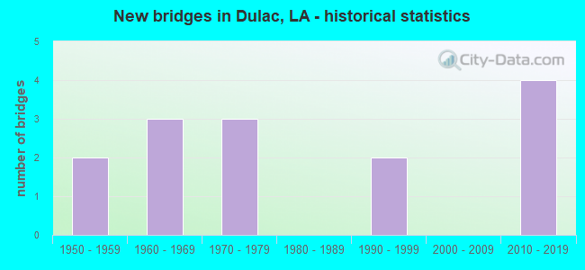
- New bridges - historical statistics
- 21950-1959
- 31960-1969
- 31970-1979
- 21990-1999
- 42010-2019

- Bridge Condition - Deck
- 7.1%Excellent
- 7.1%Very good
- 28.6%Good
- 28.6%Satisfactory
- 21.4%Fair
- 7.1%Poor

- Bridge Condition - Superstructure
- 7.1%Excellent
- 7.1%Very good
- 14.3%Good
- 21.4%Satisfactory
- 42.9%Fair
- 7.1%Poor

- Bridge Condition - Substructure
- 7.1%Very good
- 21.4%Good
- 28.6%Satisfactory
- 21.4%Fair
- 21.4%Poor

- Bridge Condition - Channel
- 28.6%Very good
- 42.9%Good
- 28.6%Satisfactory
Find on map >> Show street view
Structure Number: 2550000002054, Location: .01 MI WEST OF LA 57 (Lat: 29.372300, Lng: -90.713500), Route carried "on" structure: State highway 3011, Year Built: 2018, Status: Open, Structure Length: 3.05m (10.01ft), Average Daily Traffic: 1,403 (year 2014), Average Future Daily Traffic: 1,603 (year 2034), Design Load: HL 93, Features Intersected: SALE BAYOU
Minimum Vertical Clearance: 30+ m (98+ ft), Kilometerpoint: 0.037, Lanes on structure: 2, Owner: State Highway Agency, Approaching Roadway Width: 10.7m (35.1ft), Material/Design: Concrete, Design/Construction: Slab, Number Of Spans In Main Unit: 5, Length of Maximum Span: 6.1m (20.0ft), Curb-To-Curb Width: 9.8m (32.2ft), Out-to-Out Width: 10.9m (35.8ft)
Condition: Deck: Excellent, Superstructure: Excellent, Substructure: Good, Channel: Good, Operating Rating: 71.3 metric tons, Method Used To Determine Operating Rating: Load and Resistance Factor Rating (LRFR) rating reported by rating factor(RF) method using HL-93 loadings, Inventory Rating: 55.1 metric tons, Method Used To Determine Inventory Rating: Load and Resistance Factor Rating (LRFR) rating reported by rating factor(RF) method using HL-93 loadings, Structural Evaluation: Better than present minimum criteria, Deck Geometry: Somewhat better than minimum adequacy, Waterway Adequacy: Superior to present desirable criteria, Approach Roadway Alignment: Equal to present desirable criteria, Designated Inspection Frequency: Every 24 months, Inspection Date: April 2020, Deck Structure Type: Concrete Precast Panels
Find on map >> Show street view
Structure Number: 25500000020546, Location: 1.1 MI N OF LA 57 (Lat: 29.392661, Lng: -90.713661), Route carried "on" structure: County highway , Year Built: 2017, Status: Open, Structure Length: 2.44m (8.01ft), Average Daily Traffic: 900 (year 2011), Average Future Daily Traffic: 1,080 (year 2031), Design Load: Greater than HL93, Features Intersected: KINGS BAYOU/COULEE CANAL, Facility Carried by Structure: SHRIMPERS ROW RD
Minimum Vertical Clearance: 30+ m (98+ ft), Kilometerpoint: 5.295, Lanes on structure: 2, Owner: County Highway Agency, Approaching Roadway Width: 7.6m (24.9ft), Material/Design: Concrete, Design/Construction: Slab, Number Of Spans In Main Unit: 4, Length of Maximum Span: 6.1m (20.0ft), Curb-To-Curb Width: 7.6m (24.9ft), Out-to-Out Width: 8.2m (26.9ft)
Condition: Deck: Very good, Superstructure: Very good, Substructure: Satisfactory, Channel: Very good, Operating Rating: 57.7 metric tons, Method Used To Determine Operating Rating: Load and Resistance Factor Rating (LRFR) rating reported by rating factor(RF) method using HL-93 loadings, Inventory Rating: 44.4 metric tons, Method Used To Determine Inventory Rating: Load and Resistance Factor Rating (LRFR) rating reported by rating factor(RF) method using HL-93 loadings, Structural Evaluation: Equal to present minimum criteria, Deck Geometry: Meets minimum limits, Waterway Adequacy: Better than present minimum criteria, Approach Roadway Alignment: Better than present minimum criteria, Designated Inspection Frequency: Every 24 months, Inspection Date: April 2021, Deck Structure Type: Concrete Precast Panels
Find on map >> Show street view
Structure Number: 25500000020548, Location: 1.0 MI. N. OF LA 3011 (Lat: 29.344061, Lng: -90.728311), Route carried "on" structure: County highway , Year Built: 2018, Status: Open, Structure Length: 1.98m (6.50ft), Average Daily Traffic: 298 (year 2011), Average Future Daily Traffic: 330 (year 2031), Design Load: HL 93, Features Intersected: COULEE CANAL, Facility Carried by Structure: MAYFIELD RD
Minimum Vertical Clearance: 30+ m (98+ ft), Kilometerpoint: 0.000, Lanes on structure: 2, Owner: County Highway Agency, Approaching Roadway Width: 8.5m (27.9ft), Material/Design: Concrete, Design/Construction: Slab, Number Of Spans In Main Unit: 3, Length of Maximum Span: 7.6m (24.9ft), Curb-To-Curb Width: 8.5m (27.9ft), Out-to-Out Width: 11.0m (36.1ft)
Condition: Deck: Good, Superstructure: Good, Substructure: Very good, Channel: Very good, Operating Rating: 50.5 metric tons, Method Used To Determine Operating Rating: Load and Resistance Factor Rating (LRFR) rating reported by rating factor(RF) method using HL-93 loadings, Inventory Rating: 39.2 metric tons, Method Used To Determine Inventory Rating: Load and Resistance Factor Rating (LRFR) rating reported by rating factor(RF) method using HL-93 loadings, Structural Evaluation: Better than present minimum criteria, Deck Geometry: Equal to present minimum criteria, Waterway Adequacy: Equal to present desirable criteria, Approach Roadway Alignment: Superior to present desirable criteria, Designated Inspection Frequency: Every 24 months, Inspection Date: April 2021, Deck Structure Type: Concrete Cast-file-Place
Find on map >> Show street view
Structure Number: 2550000020081, Location: 0.01 MI W OF LA 315 (Lat: 29.459200, Lng: -90.751100), Route carried "on" structure: County highway , Year Built: 2013, Status: Open, Structure Length: 2.29m (7.51ft), Design Load: HS 20, Features Intersected: BAYOU DULARGE, Facility Carried by Structure: ST ELOI RD
Minimum Vertical Clearance: 30+ m (98+ ft), Kilometerpoint: 0.000, Lanes on structure: 2, Owner: County Highway Agency, Approaching Roadway Width: 8.2m (26.9ft), Skew: 30 degrees, Material/Design: Concrete, Design/Construction: Slab, Number Of Spans In Main Unit: 3, Length of Maximum Span: 7.6m (24.9ft), Curb or Sidewalk Widths: Left: 1.8m (5.9ft), Right: 0.8m (2.6ft), Curb-To-Curb Width: 8.2m (26.9ft), Out-to-Out Width: 12.2m (40.0ft)
Condition: Deck: Good, Superstructure: Good, Substructure: Good, Channel: Very good, Operating Rating: 52.5 metric tons, Method Used To Determine Operating Rating: Load and Resistance Factor Rating (LRFR) rating reported by rating factor(RF) method using HL-93 loadings, Inventory Rating: 40.5 metric tons, Method Used To Determine Inventory Rating: Load and Resistance Factor Rating (LRFR) rating reported by rating factor(RF) method using HL-93 loadings, Structural Evaluation: Better than present minimum criteria, Deck Geometry: Equal to present minimum criteria, Waterway Adequacy: Equal to present desirable criteria, Approach Roadway Alignment: Equal to present desirable criteria, Designated Inspection Frequency: Every 24 months, Inspection Date: May 2021, Deck Structure Type: Concrete Cast-file-Place, Wearing Surface/Protective System: Wearing Surface: Monolithic Concrete
Find on map >> Show street view
Structure Number: 25502459001261, Location: 8.6 MI SOUTH OF LA 661 (Lat: 29.462900, Lng: -90.751100), Route carried "on" structure: State highway 315, Year Built: 1953, Status: Open, Structure Length: 5.36m (17.59ft), Average Daily Traffic: 2,400 (year 2016), Truck Traffic: 12%, Average Future Daily Traffic: 2,976 (year 2036), Design Load: H 15, Features Intersected: PROVOST BAYOU
Minimum Vertical Clearance: 30+ m (98+ ft), Kilometerpoint: 1.991, Lanes on structure: 2, Owner: State Highway Agency, Approaching Roadway Width: 9.1m (29.9ft), Material/Design: Steel, Design/Construction: Movable - Swing, Number Of Spans In Main Unit: 3, Length of Maximum Span: 41.5m (136.2ft), Curb-To-Curb Width: 7.3m (24.0ft), Out-to-Out Width: 8.8m (28.9ft)
Condition: Deck: Satisfactory, Superstructure: Fair, Substructure: Poor, Channel: Satisfactory, Operating Rating: 27.5 metric tons, Method Used To Determine Operating Rating: Load and Resistance Factor Rating (LRFR) rating reported by rating factor(RF) method using HL-93 loadings, Inventory Rating: 21.1 metric tons, Method Used To Determine Inventory Rating: Load and Resistance Factor Rating (LRFR) rating reported by rating factor(RF) method using HL-93 loadings, Structural Evaluation: Meets minimum limits, Deck Geometry: High priority of replacement, Waterway Adequacy: Meets minimum limits, Approach Roadway Alignment: Better than present minimum criteria, Length Of Structure Improvement: 6.28m (20.60ft), Designated Inspection Frequency: Every 24 months, Critical Feature Inspection Frequency: Every 24 months, Other Special Inspection Frequency: Every 12 months, Inspection Date: December 2021, Critical Feature Inspection Date: December 2021, Other Special Inspection Date: December 2020, Bridge Improvement Cost: $535,000, Total Project Cost: $802,000 ( Estimate for 2016), Deck Structure Type: Concrete Cast-file-Place
Find on map >> Show street view
Structure Number: 25502460117211, Location: 11.7 MI NORTH OF LA 56 (Lat: 29.374139, Lng: -90.711800), Route carried "on" structure: State highway 57, Year Built: 1971, Status: Open, Structure Length: 14.08m (46.19ft), Average Daily Traffic: 2,000 (year 2016), Truck Traffic: 5%, Average Future Daily Traffic: 2,480 (year 2036), Design Load: HS 20, Features Intersected: BAYOU DULAC
Minimum Vertical Clearance: 5.69m (18.67ft), Kilometerpoint: 27.198, Lanes on structure: 2, Owner: State Highway Agency, Approaching Roadway Width: 11.0m (36.1ft), Navigation Control: Yes ( Vertical Clearance: 2.4m (7.9ft), Horizontal Clearance: 18.9m (62.0ft)), Material/Design: Steel, Design/Construction: Movable - Swing, Number Of Spans In Main Unit: 1, Number Of Approach Spans: 16, Length of Maximum Span: 41.1m (134.8ft), Curb or Sidewalk Widths: Left: 0.9m (3.0ft), Right: 0.9m (3.0ft), Curb-To-Curb Width: 7.5m (24.6ft), Out-to-Out Width: 9.9m (32.5ft)
Condition: Deck: Satisfactory, Superstructure: Satisfactory, Substructure: Fair, Channel: Good, Operating Rating: 28.5 metric tons, Method Used To Determine Operating Rating: Load and Resistance Factor Rating (LRFR) rating reported by rating factor(RF) method using HL-93 loadings, Inventory Rating: 21.7 metric tons, Method Used To Determine Inventory Rating: Load and Resistance Factor Rating (LRFR) rating reported by rating factor(RF) method using HL-93 loadings, Structural Evaluation: Somewhat better than minimum adequacy, Deck Geometry: Meets minimum limits, Waterway Adequacy: Equal to present desirable criteria, Approach Roadway Alignment: Somewhat better than minimum adequacy, Designated Inspection Frequency: Every 24 months, Critical Feature Inspection Frequency: Every 24 months, Underwater Inspection Frequency: Every 60 months, Inspection Date: March 2020, Critical Feature Inspection Date: March 2020, Underwater Inspection Date: May 2019, Deck Structure Type: Open Grating
Find on map >> Show street view
Structure Number: 25529205904391, Location: 0119 LOG MI FROM IN (Lat: 29.341669, Lng: -90.731700), Route carried "on" structure: County highway , Year Built: 1978, Status: Posted for load, Structure Length: 3.47m (11.38ft), Average Daily Traffic: 75 (year 1978), Average Future Daily Traffic: 93 (year 2036), Design Load: HS 20, Features Intersected: PLATT BAYOU, Facility Carried by Structure: GRAND CAILLOU RD
Minimum Vertical Clearance: 30+ m (98+ ft), Kilometerpoint: 0.000, Lanes on structure: 2, Owner: County Highway Agency, Approaching Roadway Width: 7.9m (25.9ft), Material/Design: Concrete, Design/Construction: Slab, Number Of Spans In Main Unit: 6, Length of Maximum Span: 5.8m (19.0ft), Curb-To-Curb Width: 7.4m (24.3ft), Out-to-Out Width: 8.3m (27.2ft)
Condition: Deck: Poor, Superstructure: Poor, Substructure: Poor, Channel: Very good, Operating Rating: 17.8 metric tons, Method Used To Determine Operating Rating: Load and Resistance Factor Rating (LRFR) rating reported by rating factor(RF) method using HL-93 loadings, Inventory Rating: 13.9 metric tons, Method Used To Determine Inventory Rating: Load and Resistance Factor Rating (LRFR) rating reported by rating factor(RF) method using HL-93 loadings, Structural Evaluation: Meets minimum limits, Deck Geometry: Equal to present minimum criteria, Waterway Adequacy: Equal to present desirable criteria, Approach Roadway Alignment: Better than present minimum criteria, Bridge Posting: Required (Relationship of Operating Rating to Maximum Legal Load: 20.0 - 29.9% below), Designated Inspection Frequency: Every 24 months, Underwater Inspection Frequency: Every 60 months, Other Special Inspection Frequency: Every 12 months, Inspection Date: April 2021, Underwater Inspection Date: October 2020, Other Special Inspection Date: April 2020, Deck Structure Type: Concrete Precast Panels, Wearing Surface/Protective System: Wearing Surface: Monolithic Concrete
Find on map >> Show street view
Structure Number: 25529230904301, Location: 0015 LOG MI FROM IN (Lat: 29.383331, Lng: -90.716700), Route carried "on" structure: County highway , Year Built: 1976, Status: Posted for load, Structure Length: 12.68m (41.60ft), Average Daily Traffic: 300 (year 1972), Average Future Daily Traffic: 372 (year 2036), Design Load: H 15, Features Intersected: GRAND CAILLOU BAYOU, Facility Carried by Structure: FALGOUT CANAL RD
Minimum Vertical Clearance: 4.88m (16.01ft), Kilometerpoint: 0.000, Lanes on structure: 2, Owner: County Highway Agency, Approaching Roadway Width: 8.5m (27.9ft), Navigation Control: Yes ( Vertical Clearance: 24.4m (80.1ft), Horizontal Clearance: 18.6m (61.0ft)), Material/Design: Steel, Design/Construction: Movable - Lift, Number Of Spans In Main Unit: 1, Number Of Approach Spans: 17, Length of Maximum Span: 23.2m (76.1ft), Curb-To-Curb Width: 7.3m (24.0ft), Out-to-Out Width: 8.2m (26.9ft)
Condition: Deck: Fair, Superstructure: Fair, Substructure: Satisfactory, Channel: Good, Operating Rating: 22.7 metric tons, Method Used To Determine Operating Rating: Load and Resistance Factor Rating (LRFR) rating reported by rating factor(RF) method using HL-93 loadings, Inventory Rating: 17.5 metric tons, Method Used To Determine Inventory Rating: Load and Resistance Factor Rating (LRFR) rating reported by rating factor(RF) method using HL-93 loadings, Structural Evaluation: Somewhat better than minimum adequacy, Deck Geometry: Somewhat better than minimum adequacy, Waterway Adequacy: Equal to present desirable criteria, Approach Roadway Alignment: Equal to present desirable criteria, Bridge Posting: Required (Relationship of Operating Rating to Maximum Legal Load: 0.1 - 9.9% below), Length Of Structure Improvement: 13.59m (44.59ft), Designated Inspection Frequency: Every 24 months, Critical Feature Inspection Frequency: Every 24 months, Underwater Inspection Frequency: Every 60 months, Inspection Date: June 2021, Critical Feature Inspection Date: June 2021, Underwater Inspection Date: May 2019, Bridge Improvement Cost: $811,000, Total Project Cost: $1,216,000 ( Estimate for 2016), Deck Structure Type: Open Grating
Find on map >> Show street view
Structure Number: 25529231904381, Location: 0405 LOG MI FROM IN (Lat: 29.385000, Lng: -90.730000), Route carried "on" structure: County highway , Year Built: 1958, Status: Posted for load, Structure Length: 9.94m (32.61ft), Average Daily Traffic: 400 (year 1972), Average Future Daily Traffic: 496 (year 2036), Design Load: HS 15, Features Intersected: HOUMA NAVIGATION CANAL, Facility Carried by Structure: FALGOUT CANAL RD
Minimum Vertical Clearance: 5.21m (17.09ft), Kilometerpoint: 0.000, Lanes on structure: 2, Owner: County Highway Agency, Approaching Roadway Width: 8.5m (27.9ft), Navigation Control: Yes ( Vertical Clearance: 304.5m (999.0ft), Horizontal Clearance: 54.6m (179.1ft)), Material/Design: Steel, Design/Construction: Movable - Swing, Number Of Spans In Main Unit: 11, Length of Maximum Span: 36.9m (121.1ft), Curb-To-Curb Width: 8.7m (28.5ft), Out-to-Out Width: 9.1m (29.9ft)
Condition: Deck: Satisfactory, Superstructure: Fair, Substructure: Satisfactory, Channel: Satisfactory, Operating Rating: 23.6 metric tons, Method Used To Determine Operating Rating: Allowable Stress (AS), Inventory Rating: 16.3 metric tons, Method Used To Determine Inventory Rating: Allowable Stress (AS), Structural Evaluation: Somewhat better than minimum adequacy, Deck Geometry: Equal to present minimum criteria, Waterway Adequacy: Equal to present desirable criteria, Approach Roadway Alignment: Equal to present desirable criteria, Bridge Posting: Required (Relationship of Operating Rating to Maximum Legal Load: 10.0 - 19.9% below), Designated Inspection Frequency: Every 24 months, Underwater Inspection Frequency: Every 60 months, Inspection Date: June 2021, Underwater Inspection Date: July 2021, Deck Structure Type: Steel plate, Wearing Surface/Protective System: Wearing Surface: Other
Find on map >> Show street view
Structure Number: 25529238904271, Location: 1.0 M N OF FALGOUT CA RD (Lat: 29.395369, Lng: -90.710739), Route carried "on" structure: County highway , Year Built: 1991, Status: Open, Structure Length: 1.22m (4.00ft), Average Daily Traffic: 1,670 (year 1990), Average Future Daily Traffic: 2,070 (year 2036), Design Load: HS 20, Features Intersected: CANAL, Facility Carried by Structure: Shrimpers Rowe
Minimum Vertical Clearance: 30+ m (98+ ft), Kilometerpoint: 0.000, Lanes on structure: 2, Owner: County Highway Agency, Approaching Roadway Width: 9.1m (29.9ft), Material/Design: Concrete, Design/Construction: Slab, Number Of Spans In Main Unit: 2, Length of Maximum Span: 6.1m (20.0ft), Curb-To-Curb Width: 8.6m (28.2ft), Out-to-Out Width: 9.4m (30.8ft)
Condition: Deck: Fair, Superstructure: Fair, Substructure: Satisfactory, Channel: Satisfactory, Operating Rating: 37.3 metric tons, Method Used To Determine Operating Rating: Load and Resistance Factor Rating (LRFR) rating reported by rating factor(RF) method using HL-93 loadings, Inventory Rating: 28.8 metric tons, Method Used To Determine Inventory Rating: Load and Resistance Factor Rating (LRFR) rating reported by rating factor(RF) method using HL-93 loadings, Structural Evaluation: Somewhat better than minimum adequacy, Deck Geometry: Somewhat better than minimum adequacy, Waterway Adequacy: Meets minimum limits, Approach Roadway Alignment: Equal to present desirable criteria, Designated Inspection Frequency: Every 24 months, Underwater Inspection Frequency: Every 60 months, Inspection Date: April 2021, Underwater Inspection Date: May 2019, Deck Structure Type: Concrete Cast-file-Place, Wearing Surface/Protective System: Wearing Surface: Monolithic Concrete
Find on map >> Show street view
Structure Number: 25529255904241, Location: 0.08 MI WEST OF LA 57 (Lat: 29.430231, Lng: -90.700561), Route carried "on" structure: County highway , Year Built: 1990, Status: Posted for load, Structure Length: 7.80m (25.59ft), Average Daily Traffic: 1,500 (year 2016), Average Future Daily Traffic: 1,860 (year 2036), Design Load: HS 20, Features Intersected: GRAND CAILLOU BAYOU, Facility Carried by Structure: COMBON BRIDGE RD
Minimum Vertical Clearance: 5.11m (16.77ft), Kilometerpoint: 0.000, Lanes on structure: 2, Owner: County Highway Agency, Approaching Roadway Width: 14.6m (47.9ft), Navigation Control: Yes ( Vertical Clearance: 25.3m (83.0ft), Horizontal Clearance: 18.6m (61.0ft)), Material/Design: Steel, Design/Construction: Movable - Lift, Number Of Spans In Main Unit: 1, Number Of Approach Spans: 9, Length of Maximum Span: 23.2m (76.1ft), Curb or Sidewalk Widths: Left: 1.3m (4.3ft), Right: 0.0m, Curb-To-Curb Width: 8.6m (28.2ft), Out-to-Out Width: 10.4m (34.1ft)
Condition: Deck: Good, Superstructure: Satisfactory, Substructure: Good, Channel: Good, Operating Rating: 43.1 metric tons, Method Used To Determine Operating Rating: Load and Resistance Factor Rating (LRFR) rating reported by rating factor(RF) method using HL-93 loadings, Inventory Rating: 33.4 metric tons, Method Used To Determine Inventory Rating: Load and Resistance Factor Rating (LRFR) rating reported by rating factor(RF) method using HL-93 loadings, Structural Evaluation: Equal to present minimum criteria, Deck Geometry: Somewhat better than minimum adequacy, Waterway Adequacy: Equal to present desirable criteria, Approach Roadway Alignment: Equal to present desirable criteria, Designated Inspection Frequency: Every 24 months, Critical Feature Inspection Frequency: Every 24 months, Underwater Inspection Frequency: Every 60 months, Inspection Date: June 2021, Critical Feature Inspection Date: June 2021, Underwater Inspection Date: May 2019, Deck Structure Type: Open Grating
Find on map >> Show street view
Structure Number: 25529263904241, Location: 0376 LOG MI FROM IN (Lat: 29.438331, Lng: -90.706700), Route carried "on" structure: County highway , Year Built: 1963, Status: Posted for load, Structure Length: 1.74m (5.71ft), Average Daily Traffic: 200 (year 1978), Average Future Daily Traffic: 248 (year 2036), Design Load: HS 20, Features Intersected: BAYOU PROVOST, Facility Carried by Structure: SHRIMPERS ROW
Minimum Vertical Clearance: 30+ m (98+ ft), Kilometerpoint: 0.000, Lanes on structure: 2, Owner: County Highway Agency, Approaching Roadway Width: 7.9m (25.9ft), Material/Design: Concrete, Design/Construction: Slab, Number Of Spans In Main Unit: 3, Length of Maximum Span: 5.8m (19.0ft), Curb-To-Curb Width: 7.4m (24.3ft), Out-to-Out Width: 8.4m (27.6ft)
Condition: Deck: Fair, Superstructure: Fair, Substructure: Fair, Channel: Satisfactory, Operating Rating: 24.3 metric tons, Method Used To Determine Operating Rating: Load and Resistance Factor Rating (LRFR) rating reported by rating factor(RF) method using HL-93 loadings, Inventory Rating: 18.5 metric tons, Method Used To Determine Inventory Rating: Load and Resistance Factor Rating (LRFR) rating reported by rating factor(RF) method using HL-93 loadings, Structural Evaluation: Somewhat better than minimum adequacy, Deck Geometry: Somewhat better than minimum adequacy, Waterway Adequacy: Better than present minimum criteria, Approach Roadway Alignment: Equal to present desirable criteria, Bridge Posting: Required (Relationship of Operating Rating to Maximum Legal Load: 10.0 - 19.9% below), Designated Inspection Frequency: Every 24 months, Underwater Inspection Frequency: Every 60 months, Inspection Date: April 2021, Underwater Inspection Date: July 2021, Deck Structure Type: Concrete Precast Panels, Wearing Surface/Protective System: Wearing Surface: Monolithic Concrete
Find on map >> Show street view
Structure Number: 25529278904521, Location: 0434 LOG MI FROM IN (Lat: 29.463331, Lng: -90.753300), Route carried "on" structure: County highway , Year Built: 1960, Status: Posted for load, Structure Length: 2.41m (7.91ft), Average Daily Traffic: 340 (year 1978), Average Future Daily Traffic: 421 (year 2036), Design Load: HS 20, Features Intersected: MARMANDE CANAL, Facility Carried by Structure: DR. BEATROUS RD
Minimum Vertical Clearance: 30+ m (98+ ft), Kilometerpoint: 0.000, Lanes on structure: 2, Owner: County Highway Agency, Approaching Roadway Width: 7.3m (24.0ft), Material/Design: Steel continuous, Design/Construction: Stringer/Multi-beam, Number Of Spans In Main Unit: 4, Length of Maximum Span: 6.1m (20.0ft), Curb-To-Curb Width: 7.3m (24.0ft), Out-to-Out Width: 7.4m (24.3ft)
Condition: Deck: Good, Superstructure: Fair, Substructure: Fair, Channel: Good, Operating Rating: 18.1 metric tons, Method Used To Determine Operating Rating: Allowable Stress (AS), Inventory Rating: 13.6 metric tons, Method Used To Determine Inventory Rating: Allowable Stress (AS), Structural Evaluation: Meets minimum limits, Deck Geometry: Somewhat better than minimum adequacy, Waterway Adequacy: Better than present minimum criteria, Approach Roadway Alignment: High priority of corrective action, Bridge Posting: Required (Relationship of Operating Rating to Maximum Legal Load: 30.0 - 39.9% below), Length Of Structure Improvement: 3.17m (10.40ft), Designated Inspection Frequency: Every 24 months, Other Special Inspection Frequency: Every 12 months, Inspection Date: May 2021, Other Special Inspection Date: May 2020, Bridge Improvement Cost: $189,000, Total Project Cost: $283,000 ( Estimate for 2016), Deck Structure Type: Wood or Timber, Wearing Surface/Protective System: Wearing Surface: Other
Find on map >> Show street view
Structure Number: 25529283904221, Location: 0005 LOG MI FROM IN (Lat: 29.472581, Lng: -90.702239), Route carried "on" structure: County highway , Year Built: 1960, Status: Posted for load, Structure Length: 4.82m (15.81ft), Average Daily Traffic: 400 (year 1978), Average Future Daily Traffic: 496 (year 2036), Design Load: HS 20, Features Intersected: GRAND CAILLOU BAYOU, Facility Carried by Structure: BOBTOWN BRIDGE RD
Minimum Vertical Clearance: 4.44m (14.57ft), Kilometerpoint: 0.000, Lanes on structure: 1, Owner: County Highway Agency, Approaching Roadway Width: 7.3m (24.0ft), Navigation Control: Yes ( Vertical Clearance: 1.5m (4.9ft), Horizontal Clearance: 14.9m (48.9ft)), Material/Design: Steel, Design/Construction: Movable - Swing, Number Of Spans In Main Unit: 1, Number Of Approach Spans: 2, Length of Maximum Span: 19.5m (64.0ft), Curb-To-Curb Width: 4.1m (13.5ft), Out-to-Out Width: 4.9m (16.1ft)
Condition: Deck: Satisfactory, Superstructure: Satisfactory, Substructure: Poor, Channel: Good, Operating Rating: 13.9 metric tons, Method Used To Determine Operating Rating: Load and Resistance Factor Rating (LRFR) rating reported by rating factor(RF) method using HL-93 loadings, Inventory Rating: 10.7 metric tons, Method Used To Determine Inventory Rating: Load and Resistance Factor Rating (LRFR) rating reported by rating factor(RF) method using HL-93 loadings, Structural Evaluation: High priority of replacement, Deck Geometry: High priority of replacement, Waterway Adequacy: Better than present minimum criteria, Approach Roadway Alignment: Equal to present minimum criteria, Bridge Posting: Required (Relationship of Operating Rating to Maximum Legal Load: > 39.9% below), Length Of Structure Improvement: 5.73m (18.80ft), Designated Inspection Frequency: Every 24 months, Critical Feature Inspection Frequency: Every 24 months, Underwater Inspection Frequency: Every 60 months, Other Special Inspection Frequency: Every 12 months, Inspection Date: June 2021, Critical Feature Inspection Date: June 2021, Underwater Inspection Date: May 2019, Other Special Inspection Date: June 2020, Bridge Improvement Cost: $342,000, Total Project Cost: $513,000 ( Estimate for 2016), Deck Structure Type: Wood or Timber, Wearing Surface/Protective System: Wearing Surface: Other