Bridge Statistics for Dublin, Pennsylvania (PA)
Condition, Traffic, Stress, Structural Evaluation, Project Costs
- National Bridge Inventory (NBI) Statistics
- 34Number of bridges
- 384ft / 117mTotal length
- $19,671,000Total costs
- 55,623Total average daily traffic
- 6,831Total average daily truck traffic
- 62,567Total future (year 2011) average daily traffic
- National Bridge Inventory (NBI) Registered Bridges for Dublin
- No street view available for this location
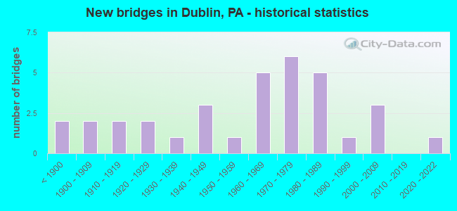
- New bridges - historical statistics
- 2Before 1900
- 21900-1909
- 21910-1919
- 21920-1929
- 11930-1939
- 31940-1949
- 11950-1959
- 51960-1969
- 61970-1979
- 51980-1989
- 11990-1999
- 32000-2009
- 12020-2022

- Reconstructed bridges - Historical Statistics
- 11990-1999
- 72000-2009
- 32010-2019


- Bridge Condition - Deck
- 7.1%Excellent
- 21.4%Very good
- 25.0%Good
- 25.0%Satisfactory
- 10.7%Fair
- 10.7%Poor

- Bridge Condition - Superstructure
- 3.4%Excellent
- 17.2%Very good
- 17.2%Good
- 27.6%Satisfactory
- 17.2%Fair
- 10.3%Poor
- 6.9%Serious

- Bridge Condition - Substructure
- 3.4%Very good
- 31.0%Good
- 24.1%Satisfactory
- 31.0%Fair
- 10.3%Poor

- Bridge Condition - Channel
- 3.0%Very good
- 18.2%Good
- 21.2%Satisfactory
- 42.4%Fair
- 15.2%Poor

- Bridge Condition - Culverts
- 20.0%Excellent
- 40.0%Very good
- 20.0%Satisfactory
- 20.0%Poor
Find on map >> Show street view
Structure Number: 5707, Location: 1 MI.E.OF ARCH SPRING (Lat: 40.613317, Lng: -78.182092), Route carried "on" structure: State highway , Year Built: 1999, Status: Open, Structure Length: 2.93m (9.61ft), Average Daily Traffic: 633 (year 2022), Truck Traffic: 4%, Average Future Daily Traffic: 929 (year 2032), Design Load: HS 25 or greater, Features Intersected: SINKING RUN, Facility Carried by Structure: SR 1013
Minimum Vertical Clearance: 30+ m (98+ ft), Kilometerpoint: 22.943, Lanes on structure: 2, Owner: State Highway Agency, Approaching Roadway Width: 9.1m (29.9ft), Skew: 5 degrees, Material/Design: Prestressed concrete, Design/Construction: Box Beam or Girders - Single/Spread, Number Of Spans In Main Unit: 2, Length of Maximum Span: 14.0m (45.9ft), Curb or Sidewalk Widths: Left: 0.2m (0.7ft), Right: 0.2m (0.7ft), Curb-To-Curb Width: 9.1m (29.9ft), Out-to-Out Width: 10.0m (32.8ft)
Condition: Deck: Good, Superstructure: Good, Substructure: Good, Channel: Fair, Operating Rating: 89.8 metric tons, Method Used To Determine Operating Rating: Load Factor (LF), Inventory Rating: 44.5 metric tons, Method Used To Determine Inventory Rating: Load Factor (LF), Structural Evaluation: Better than present minimum criteria, Deck Geometry: Equal to present minimum criteria, Waterway Adequacy: Equal to present desirable criteria, Approach Roadway Alignment: Equal to present desirable criteria, Length Of Structure Improvement: 3.30m (10.83ft), Designated Inspection Frequency: Every 48 months, Inspection Date: April 2019, Bridge Improvement Cost: $83,000, Roadway Improvement Cost: $264,000, Total Project Cost: $1,117,000, Deck Structure Type: Concrete Cast-file-Place, Wearing Surface/Protective System: Wearing Surface: Monolithic Concrete, Deck Protection: Epoxy Coated Reinforcing
Find on map >> Show street view
Structure Number: 6594, Location: 1.1 M. W OF SAYEES CORNER (Lat: 41.716914, Lng: -76.666853), Route carried "on" structure: City street , Year Built: 1974, Status: Open, Structure Length: 1.16m (3.81ft), Average Daily Traffic: 75 (year 2021), Truck Traffic: 5%, Average Future Daily Traffic: 116 (year 2043), Design Load: HS 20, Features Intersected: NORTH BR. TOWANDA CREEK, Facility Carried by Structure: TR-365 (TWP.BR. #2
Minimum Vertical Clearance: 30+ m (98+ ft), Kilometerpoint: 0.000, Lanes on structure: 1, Owner: Town or Township Highway Agency, Approaching Roadway Width: 5.2m (17.1ft), Skew: 1 degrees, Material/Design: Steel, Design/Construction: Stringer/Multi-beam, Number Of Spans In Main Unit: 1, Length of Maximum Span: 10.4m (34.1ft), Curb or Sidewalk Widths: Left: 0.2m (0.7ft), Right: 0.2m (0.7ft), Curb-To-Curb Width: 4.5m (14.8ft), Out-to-Out Width: 4.8m (15.7ft)
Condition: Deck: Satisfactory, Superstructure: Fair, Substructure: Fair, Channel: Fair, Operating Rating: 73.5 metric tons, Method Used To Determine Operating Rating: Load Factor (LF), Inventory Rating: 44.5 metric tons, Method Used To Determine Inventory Rating: Load Factor (LF), Structural Evaluation: Somewhat better than minimum adequacy, Deck Geometry: Equal to present minimum criteria, Waterway Adequacy: Equal to present minimum criteria, Approach Roadway Alignment: Meets minimum limits, Length Of Structure Improvement: 1.10m (3.61ft), Designated Inspection Frequency: Every 24 months, Inspection Date: July 2021, Deck Structure Type: Wood or Timber
Find on map >> Show street view
Structure Number: 6887, Location: BLOOMING GLEN 15E13 (Lat: 40.374103, Lng: -75.238300), Route carried "on" structure: State highway 113, Year Built: 1902, Year Reconstructed: 2011, Status: Open, Structure Length: 1.52m (4.99ft), Average Daily Traffic: 6,169 (year 2020), Truck Traffic: 9%, Average Future Daily Traffic: 8,351 (year 2032), Design Load: H 15, Features Intersected: MORRIS RUN, Facility Carried by Structure: SOUDERTON PIKE
Minimum Vertical Clearance: 30+ m (98+ ft), Kilometerpoint: 8.230, Lanes on structure: 2, Owner: State Highway Agency, Approaching Roadway Width: 7.6m (24.9ft), Material/Design: Masonry, Design/Construction: Arch - Deck, Number Of Spans In Main Unit: 3, Length of Maximum Span: 6.1m (20.0ft), Curb-To-Curb Width: 6.2m (20.3ft), Out-to-Out Width: 7.4m (24.3ft)
Condition: Deck: Very good, Superstructure: Good, Substructure: Good, Channel: Fair, Operating Rating: 71.7 metric tons, Method Used To Determine Operating Rating: Field evaluation and documented engineering judgment, Inventory Rating: 42.6 metric tons, Method Used To Determine Inventory Rating: Field evaluation and documented engineering judgment, Structural Evaluation: Better than present minimum criteria, Deck Geometry: High priority of replacement, Waterway Adequacy: Equal to present minimum criteria, Approach Roadway Alignment: Equal to present desirable criteria, Length Of Structure Improvement: 2.20m (7.22ft), Designated Inspection Frequency: Every 24 months, Inspection Date: March 2021, Bridge Improvement Cost: $45,000, Roadway Improvement Cost: $132,000, Total Project Cost: $605,000, Deck Structure Type: Concrete Cast-file-Place, Wearing Surface/Protective System: Wearing Surface: Bituminous, Membrane: Other, Deck Protection: Epoxy Coated Reinforcing
Find on map >> Show street view
Structure Number: 7367, Location: 1MI.S.W.DUBLIN BOR 21J03 (Lat: 40.358517, Lng: -75.216014), Route carried "on" structure: State highway , Year Built: 1872, Status: Posted for load, Structure Length: 1.34m (4.40ft), Average Daily Traffic: 3,355 (year 2022), Truck Traffic: 4%, Average Future Daily Traffic: 2,979 (year 2032), Design Load: H 15, Features Intersected: MORRIS RUN, Facility Carried by Structure: DUBLIN ROAD
Minimum Vertical Clearance: 30+ m (98+ ft), Kilometerpoint: 7.075, Lanes on structure: 2, Owner: State Highway Agency, Approaching Roadway Width: 6.4m (21.0ft), Material/Design: Masonry, Design/Construction: Arch - Deck, Number Of Spans In Main Unit: 3, Length of Maximum Span: 3.7m (12.1ft), Curb-To-Curb Width: 5.0m (16.4ft), Out-to-Out Width: 6.3m (20.7ft)
Condition: Superstructure: Poor, Substructure: Poor, Channel: Poor, Operating Rating: 33.6 metric tons, Method Used To Determine Operating Rating: Field evaluation and documented engineering judgment, Inventory Rating: 20.0 metric tons, Method Used To Determine Inventory Rating: Field evaluation and documented engineering judgment, Structural Evaluation: Meets minimum limits, Deck Geometry: High priority of replacement, Waterway Adequacy: Equal to present desirable criteria, Approach Roadway Alignment: Equal to present desirable criteria, Length Of Structure Improvement: 1.70m (5.58ft), Designated Inspection Frequency: Every 24 months, Other Special Inspection Frequency: Every 12 months, Inspection Date: March 2020, Other Special Inspection Date: March 2021, Bridge Improvement Cost: $13,000, Roadway Improvement Cost: $98,000, Total Project Cost: $179,000
Find on map >> Show street view
Structure Number: 7368, Location: JUST SE OF TR 113 15K10 (Lat: 40.394533, Lng: -75.207747), Route carried "on" structure: State highway , Year Built: 1989, Status: Open, Structure Length: 1.07m (3.51ft), Average Daily Traffic: 1,931 (year 2022), Truck Traffic: 2%, Average Future Daily Traffic: 3,142 (year 2032), Design Load: HS 25 or greater, Features Intersected: BRANCH OF DEEP RUN, Facility Carried by Structure: ELEPHANT ROAD
Minimum Vertical Clearance: 30+ m (98+ ft), Kilometerpoint: 11.571, Lanes on structure: 2, Owner: State Highway Agency, Approaching Roadway Width: 10.4m (34.1ft), Skew: 1 degrees, Material/Design: Prestressed concrete, Design/Construction: Box Beam or Girders - Multiple, Number Of Spans In Main Unit: 1, Length of Maximum Span: 10.4m (34.1ft), Curb or Sidewalk Widths: Left: 0.2m (0.7ft), Right: 0.2m (0.7ft), Curb-To-Curb Width: 10.0m (32.8ft), Out-to-Out Width: 11.1m (36.4ft)
Condition: Deck: Good, Superstructure: Very good, Substructure: Good, Channel: Satisfactory, Operating Rating: 97.1 metric tons, Method Used To Determine Operating Rating: Load Factor (LF), Inventory Rating: 47.2 metric tons, Method Used To Determine Inventory Rating: Load Factor (LF), Structural Evaluation: Better than present minimum criteria, Deck Geometry: Somewhat better than minimum adequacy, Waterway Adequacy: Better than present minimum criteria, Approach Roadway Alignment: Better than present minimum criteria, Length Of Structure Improvement: 1.80m (5.91ft), Designated Inspection Frequency: Every 24 months, Inspection Date: June 2020, Deck Structure Type: Concrete Cast-file-Place, Wearing Surface/Protective System: Wearing Surface: Monolithic Concrete, Deck Protection: Epoxy Coated Reinforcing
Find on map >> Show street view
Structure Number: 7369, Location: JUST SE OF TR 113 15H07 (Lat: 40.410558, Lng: -75.223586), Route carried "on" structure: State highway , Year Built: 1978, Status: Open, Structure Length: 1.04m (3.41ft), Average Daily Traffic: 1,009 (year 2022), Truck Traffic: 9%, Average Future Daily Traffic: 2,040 (year 2032), Design Load: HS 20, Features Intersected: E.BRANCH PERKIOMEN CREEK, Facility Carried by Structure: ELEPHANT ROAD
Minimum Vertical Clearance: 30+ m (98+ ft), Kilometerpoint: 14.297, Lanes on structure: 2, Owner: State Highway Agency, Approaching Roadway Width: 6.7m (22.0ft), Skew: 3 degrees, Material/Design: Prestressed concrete, Design/Construction: Slab, Number Of Spans In Main Unit: 1, Length of Maximum Span: 10.1m (33.1ft), Curb or Sidewalk Widths: Left: 0.2m (0.7ft), Right: 0.2m (0.7ft), Curb-To-Curb Width: 7.5m (24.6ft), Out-to-Out Width: 8.6m (28.2ft)
Condition: Deck: Good, Superstructure: Satisfactory, Substructure: Good, Channel: Fair, Operating Rating: 72.6 metric tons, Method Used To Determine Operating Rating: Load Factor (LF), Inventory Rating: 36.3 metric tons, Method Used To Determine Inventory Rating: Load Factor (LF), Structural Evaluation: Equal to present minimum criteria, Deck Geometry: Meets minimum limits, Waterway Adequacy: Equal to present minimum criteria, Approach Roadway Alignment: Better than present minimum criteria, Length Of Structure Improvement: 1.70m (5.58ft), Designated Inspection Frequency: Every 24 months, Inspection Date: June 2020, Deck Structure Type: Concrete Cast-file-Place, Wearing Surface/Protective System: Wearing Surface: Monolithic Concrete, Deck Protection: Epoxy Coated Reinforcing
Find on map >> Show street view
Structure Number: 739, Location: .5MI.S.ROUTE 113 21E01 (Lat: 40.373547, Lng: -75.237531), Route carried "on" structure: State highway , Year Built: 1973, Status: Open, Structure Length: 0.64m (2.10ft), Average Daily Traffic: 2,672 (year 2022), Truck Traffic: 9%, Average Future Daily Traffic: 2,433 (year 2032), Design Load: HS 20, Features Intersected: BRANCH OF MORRIS RUN, Facility Carried by Structure: MINSI TRAIL
Minimum Vertical Clearance: 30+ m (98+ ft), Kilometerpoint: 2.820, Lanes on structure: 2, Owner: State Highway Agency, Approaching Roadway Width: 6.1m (20.0ft), Skew: 4 degrees, Material/Design: Concrete, Design/Construction: Culvert, Number Of Spans In Main Unit: 1, Length of Maximum Span: 6.4m (21.0ft), Curb-To-Curb Width: 9.0m (29.5ft), Out-to-Out Width: 10.4m (34.1ft)
Condition: Channel: Fair, Culverts: Satisfactory, Operating Rating: 45.4 metric tons, Method Used To Determine Operating Rating: Load Factor (LF), Inventory Rating: 27.2 metric tons, Method Used To Determine Inventory Rating: Load Factor (LF), Structural Evaluation: Equal to present minimum criteria, Deck Geometry: Meets minimum limits, Waterway Adequacy: Equal to present minimum criteria, Approach Roadway Alignment: Equal to present desirable criteria, Length Of Structure Improvement: 1.40m (4.59ft), Designated Inspection Frequency: Every 24 months, Inspection Date: July 2020, Deck Structure Type: Concrete Cast-file-Place, Wearing Surface/Protective System: Wearing Surface: Bituminous
Find on map >> Show street view
Structure Number: 7391, Location: SOUTH ROUTE 113 15E13 (Lat: 40.373519, Lng: -75.237483), Route carried "on" structure: State highway , Year Built: 1973, Status: Open, Structure Length: 1.01m (3.31ft), Average Daily Traffic: 2,672 (year 2022), Truck Traffic: 9%, Average Future Daily Traffic: 2,433 (year 2032), Design Load: HS 20, Features Intersected: MORRIS RUN, Facility Carried by Structure: MINSI TRAIL
Minimum Vertical Clearance: 30+ m (98+ ft), Kilometerpoint: 2.820, Lanes on structure: 2, Owner: State Highway Agency, Approaching Roadway Width: 13.7m (44.9ft), Material/Design: Prestressed concrete, Design/Construction: Slab, Number Of Spans In Main Unit: 1, Length of Maximum Span: 9.8m (32.2ft), Curb or Sidewalk Widths: Left: 0.2m (0.7ft), Right: 0.2m (0.7ft), Curb-To-Curb Width: 13.5m (44.3ft), Out-to-Out Width: 14.7m (48.2ft)
Condition: Deck: Good, Superstructure: Satisfactory, Substructure: Satisfactory, Channel: Fair, Operating Rating: 95.3 metric tons, Method Used To Determine Operating Rating: Load Factor (LF), Inventory Rating: 43.5 metric tons, Method Used To Determine Inventory Rating: Load Factor (LF), Structural Evaluation: Equal to present minimum criteria, Deck Geometry: Superior to present desirable criteria, Waterway Adequacy: Better than present minimum criteria, Approach Roadway Alignment: Equal to present desirable criteria, Length Of Structure Improvement: 1.60m (5.25ft), Designated Inspection Frequency: Every 24 months, Inspection Date: December 2020, Deck Structure Type: Concrete Cast-file-Place, Wearing Surface/Protective System: Wearing Surface: Bituminous
Find on map >> Show street view
Structure Number: 7394, Location: .3MI.WEST TR-313 15E11 (Lat: 40.388922, Lng: -75.239703), Route carried "on" structure: State highway , Year Built: 1902, Status: Open, Structure Length: 1.62m (5.31ft), Average Daily Traffic: 384 (year 2022), Truck Traffic: 9%, Average Future Daily Traffic: 617 (year 2032), Design Load: H 15, Features Intersected: MORRIS RUN, Facility Carried by Structure: BLUE SCHOOL ROAD
Minimum Vertical Clearance: 30+ m (98+ ft), Kilometerpoint: 2.179, Lanes on structure: 2, Owner: State Highway Agency, Approaching Roadway Width: 6.7m (22.0ft), Material/Design: Masonry, Design/Construction: Arch - Deck, Number Of Spans In Main Unit: 2, Length of Maximum Span: 7.0m (23.0ft), Curb-To-Curb Width: 5.4m (17.7ft), Out-to-Out Width: 6.5m (21.3ft)
Condition: Superstructure: Fair, Substructure: Fair, Channel: Poor, Operating Rating: 55.3 metric tons, Method Used To Determine Operating Rating: Field evaluation and documented engineering judgment, Inventory Rating: 27.2 metric tons, Method Used To Determine Inventory Rating: Field evaluation and documented engineering judgment, Structural Evaluation: Somewhat better than minimum adequacy, Deck Geometry: High priority of replacement, Waterway Adequacy: Equal to present desirable criteria, Approach Roadway Alignment: Equal to present desirable criteria, Length Of Structure Improvement: 2.30m (7.55ft), Designated Inspection Frequency: Every 24 months, Underwater Inspection Frequency: Every 24 months, Inspection Date: March 2021, Underwater Inspection Date: September 2021, Bridge Improvement Cost: $11,000, Roadway Improvement Cost: $34,000, Total Project Cost: $153,000
Find on map >> Show street view
Structure Number: 7396, Location: BEDMINSTER TWP. 16A09 (Lat: 40.398139, Lng: -75.202556), Route carried "on" structure: State highway , Year Built: 1928, Status: Open, Structure Length: 1.46m (4.79ft), Average Daily Traffic: 831 (year 2022), Truck Traffic: 9%, Average Future Daily Traffic: 1,637 (year 2032), Design Load: H 20, Features Intersected: BRANCH OF DEEP RUN, Facility Carried by Structure: IRISH MEETINGHOUSE
Minimum Vertical Clearance: 30+ m (98+ ft), Kilometerpoint: 0.566, Lanes on structure: 2, Owner: State Highway Agency, Approaching Roadway Width: 6.1m (20.0ft), Skew: 3 degrees, Material/Design: Concrete, Design/Construction: Tee Beam, Number Of Spans In Main Unit: 2, Length of Maximum Span: 6.1m (20.0ft), Curb-To-Curb Width: 5.9m (19.4ft), Out-to-Out Width: 6.7m (22.0ft)
Condition: Deck: Satisfactory, Superstructure: Fair, Substructure: Fair, Channel: Poor, Operating Rating: 65.3 metric tons, Method Used To Determine Operating Rating: Field evaluation and documented engineering judgment, Inventory Rating: 32.7 metric tons, Method Used To Determine Inventory Rating: Field evaluation and documented engineering judgment, Structural Evaluation: Somewhat better than minimum adequacy, Deck Geometry: High priority of replacement, Waterway Adequacy: Equal to present minimum criteria, Approach Roadway Alignment: Better than present minimum criteria, Length Of Structure Improvement: 2.00m (6.56ft), Designated Inspection Frequency: Every 24 months, Inspection Date: October 2020, Bridge Improvement Cost: $10,000, Roadway Improvement Cost: $31,000, Total Project Cost: $140,000, Deck Structure Type: Concrete Cast-file-Place, Wearing Surface/Protective System: Wearing Surface: Bituminous
Find on map >> Show street view
Structure Number: 7397, Location: BEDMINSTER TWP. 16B08 (Lat: 40.401719, Lng: -75.191706), Route carried "on" structure: State highway , Year Built: 1963, Year Reconstructed: 2011, Status: Open, Structure Length: 1.34m (4.40ft), Average Daily Traffic: 831 (year 2022), Truck Traffic: 9%, Average Future Daily Traffic: 1,637 (year 2032), Design Load: HL 93, Features Intersected: DEEP RUN, Facility Carried by Structure: IRISH MEETINGHOUSE
Minimum Vertical Clearance: 30+ m (98+ ft), Kilometerpoint: 1.225, Lanes on structure: 2, Owner: State Highway Agency, Approaching Roadway Width: 9.4m (30.8ft), Skew: 1 degrees, Material/Design: Prestressed concrete, Design/Construction: Box Beam or Girders - Multiple, Number Of Spans In Main Unit: 1, Length of Maximum Span: 13.1m (43.0ft), Curb-To-Curb Width: 9.2m (30.2ft), Out-to-Out Width: 10.2m (33.5ft)
Condition: Deck: Good, Superstructure: Very good, Substructure: Good, Channel: Fair, Operating Rating: 55.1 metric tons, Method Used To Determine Operating Rating: Assigned ratings based on Load and Resistance Factor Design (LRFD) reported by rating factor (RF) using HL93 loadings, Inventory Rating: 34.7 metric tons, Method Used To Determine Inventory Rating: Assigned ratings based on Load and Resistance Factor Design (LRFD) reported by rating factor (RF) using HL93 loadings, Structural Evaluation: Better than present minimum criteria, Deck Geometry: Equal to present minimum criteria, Waterway Adequacy: Better than present minimum criteria, Approach Roadway Alignment: Equal to present desirable criteria, Length Of Structure Improvement: 2.00m (6.56ft), Designated Inspection Frequency: Every 24 months, Inspection Date: April 2021, Bridge Improvement Cost: $39,000, Roadway Improvement Cost: $114,000, Total Project Cost: $524,000, Deck Structure Type: Concrete Cast-file-Place, Wearing Surface/Protective System: Wearing Surface: Monolithic Concrete, Membrane: Other, Deck Protection: Epoxy Coated Reinforcing
Find on map >> Show street view
Structure Number: 7514, Location: HILLTOWN TOWNSHIP2809-B10 (Lat: 40.378475, Lng: -75.239603), Route carried "on" structure: City street , Year Built: 1911, Status: Posted for load, Structure Length: 1.98m (6.50ft), Average Daily Traffic: 100 (year 2001), Truck Traffic: 1%, Average Future Daily Traffic: 140 (year 2013), Features Intersected: MORRIS RUN, Facility Carried by Structure: SCHWENK MILL ROAD
Minimum Vertical Clearance: 30+ m (98+ ft), Kilometerpoint: 0.000, Lanes on structure: 1, Owner: County Highway Agency, Approaching Roadway Width: 4.9m (16.1ft), Skew: 3 degrees, Material/Design: Concrete, Design/Construction: Arch - Deck, Number Of Spans In Main Unit: 1, Length of Maximum Span: 18.3m (60.0ft), Curb-To-Curb Width: 4.6m (15.1ft), Out-to-Out Width: 5.7m (18.7ft)
Condition: Deck: Poor, Superstructure: Poor, Substructure: Poor, Channel: Poor, Operating Rating: 34.5 metric tons, Method Used To Determine Operating Rating: Field evaluation and documented engineering judgment, Inventory Rating: 20.0 metric tons, Method Used To Determine Inventory Rating: Field evaluation and documented engineering judgment, Structural Evaluation: Meets minimum limits, Deck Geometry: Better than present minimum criteria, Waterway Adequacy: Better than present minimum criteria, Approach Roadway Alignment: Meets minimum limits, Bridge Posting: Required (Relationship of Operating Rating to Maximum Legal Load: 10.0 - 19.9% below), Length Of Structure Improvement: 2.10m (6.89ft), Designated Inspection Frequency: Every 24 months, Other Special Inspection Frequency: Every 12 months, Inspection Date: April 2020, Other Special Inspection Date: April 2021, Bridge Improvement Cost: $64,000, Roadway Improvement Cost: $366,000, Total Project Cost: $859,000, Deck Structure Type: Concrete Cast-file-Place, Wearing Surface/Protective System: Wearing Surface: Bituminous
Find on map >> Show street view
Structure Number: 754, Location: BEDMINSTER TWP. 15H05 (Lat: 40.417597, Lng: -75.219497), Route carried "on" structure: City street , Year Built: 1980, Status: Open, Structure Length: 1.07m (3.51ft), Average Daily Traffic: 100 (year 2001), Average Future Daily Traffic: 105 (year 2011), Design Load: HS 20, Features Intersected: EAST BR.PERKIOMEN CREEK, Facility Carried by Structure: SPRUCE LANE
Minimum Vertical Clearance: 30+ m (98+ ft), Kilometerpoint: 0.000, Lanes on structure: 2, Owner: County Highway Agency, Approaching Roadway Width: 5.8m (19.0ft), Material/Design: Prestressed concrete, Design/Construction: Box Beam or Girders - Multiple, Number Of Spans In Main Unit: 1, Length of Maximum Span: 10.4m (34.1ft), Curb or Sidewalk Widths: Left: 0.2m (0.7ft), Right: 0.2m (0.7ft), Curb-To-Curb Width: 8.5m (27.9ft), Out-to-Out Width: 9.6m (31.5ft)
Condition: Deck: Fair, Superstructure: Fair, Substructure: Good, Channel: Fair, Operating Rating: 51.7 metric tons, Method Used To Determine Operating Rating: Field evaluation and documented engineering judgment, Inventory Rating: 30.8 metric tons, Method Used To Determine Inventory Rating: Field evaluation and documented engineering judgment, Structural Evaluation: Somewhat better than minimum adequacy, Deck Geometry: Better than present minimum criteria, Waterway Adequacy: Better than present minimum criteria, Approach Roadway Alignment: Equal to present desirable criteria, Length Of Structure Improvement: 1.80m (5.91ft), Designated Inspection Frequency: Every 24 months, Inspection Date: March 2020, Deck Structure Type: Other, Wearing Surface/Protective System: Wearing Surface: Bituminous, Membrane: Preformed Fabric
Find on map >> Show street view
Structure Number: 7543, Location: 2.5 Mi E. PA-611 2810-A5 (Lat: 40.408722, Lng: -75.186253), Route carried "on" structure: City street , Year Built: 1981, Status: Open, Structure Length: 2.59m (8.50ft), Average Daily Traffic: 100 (year 2001), Average Future Daily Traffic: 150 (year 2015), Design Load: HS 20, Features Intersected: Deep Run, Facility Carried by Structure: Hill Road
Minimum Vertical Clearance: 30+ m (98+ ft), Kilometerpoint: 0.000, Lanes on structure: 2, Owner: County Highway Agency, Approaching Roadway Width: 8.5m (27.9ft), Material/Design: Prestressed concrete, Design/Construction: Box Beam or Girders - Multiple, Number Of Spans In Main Unit: 2, Length of Maximum Span: 11.9m (39.0ft), Curb-To-Curb Width: 8.4m (27.6ft), Out-to-Out Width: 9.6m (31.5ft)
Condition: Deck: Satisfactory, Superstructure: Good, Substructure: Fair, Channel: Satisfactory, Inventory Rating: 67.1 metric tons, Method Used To Determine Inventory Rating: Load Factor (LF), Structural Evaluation: Somewhat better than minimum adequacy, Deck Geometry: Equal to present minimum criteria, Waterway Adequacy: Superior to present desirable criteria, Approach Roadway Alignment: Equal to present desirable criteria, Length Of Structure Improvement: 3.40m (11.15ft), Designated Inspection Frequency: Every 24 months, Inspection Date: May 2020, Deck Structure Type: Concrete Cast-file-Place, Wearing Surface/Protective System: Wearing Surface: Monolithic Concrete, Deck Protection: Epoxy Coated Reinforcing
Find on map >> Show street view
Structure Number: 7555, Location: 2500 FT W SR 313; 2921-E1 (Lat: 40.372975, Lng: -75.220253), Route carried "on" structure: City street , Year Built: 1889, Year Reconstructed: 2011, Status: Posted for load, Structure Length: 1.95m (6.40ft), Average Daily Traffic: 200 (year 2001), Average Future Daily Traffic: 420 (year 2011), Features Intersected: MORRIS RUN, Facility Carried by Structure: QUARRY ROAD
Minimum Vertical Clearance: 30+ m (98+ ft), Kilometerpoint: 0.000, Lanes on structure: 1, Owner: County Highway Agency, Approaching Roadway Width: 4.9m (16.1ft), Skew: 1 degrees, Material/Design: Steel, Design/Construction: Truss - Thru, Number Of Spans In Main Unit: 1, Length of Maximum Span: 18.6m (61.0ft), Curb-To-Curb Width: 4.6m (15.1ft), Out-to-Out Width: 4.9m (16.1ft)
Condition: Deck: Good, Superstructure: Satisfactory, Substructure: Satisfactory, Channel: Satisfactory, Operating Rating: 13.6 metric tons, Method Used To Determine Operating Rating: Load and Resistance Factor (LRFR), Inventory Rating: 9.1 metric tons, Method Used To Determine Inventory Rating: Load and Resistance Factor (LRFR), Structural Evaluation: High priority of corrective action, Deck Geometry: High priority of replacement, Waterway Adequacy: Somewhat better than minimum adequacy, Approach Roadway Alignment: Better than present minimum criteria, Bridge Posting: Required (Relationship of Operating Rating to Maximum Legal Load: > 39.9% below), Length Of Structure Improvement: 2.40m (7.87ft), Designated Inspection Frequency: Every 24 months, Critical Feature Inspection Frequency: Every 12 months, Other Special Inspection Frequency: Every 12 months, Inspection Date: July 2020, Critical Feature Inspection Date: July 2021, Other Special Inspection Date: July 2021, Bridge Improvement Cost: $49,000, Roadway Improvement Cost: $161,000, Total Project Cost: $660,000, Deck Structure Type: Open Grating
Find on map >> Show street view
Structure Number: 7982, Location: WEST OF BRUIN (Lat: 41.044328, Lng: -79.776492), Route carried "on" structure: State highway , Year Built: 1939, Status: Open, Structure Length: 1.52m (4.99ft), Average Daily Traffic: 693 (year 2022), Truck Traffic: 17%, Average Future Daily Traffic: 737 (year 2032), Design Load: H 20, Features Intersected: SILVER CREEK, Facility Carried by Structure: SR1004
Minimum Vertical Clearance: 30+ m (98+ ft), Kilometerpoint: 3.701, Lanes on structure: 2, Owner: State Highway Agency, Approaching Roadway Width: 7.0m (23.0ft), Skew: 4 degrees, Material/Design: Steel, Design/Construction: Stringer/Multi-beam, Number Of Spans In Main Unit: 1, Length of Maximum Span: 14.0m (45.9ft), Curb or Sidewalk Widths: Left: 0.2m (0.7ft), Right: 0.2m (0.7ft), Curb-To-Curb Width: 7.9m (25.9ft), Out-to-Out Width: 9.1m (29.9ft)
Condition: Deck: Satisfactory, Superstructure: Good, Substructure: Fair, Channel: Fair, Operating Rating: 89.8 metric tons, Method Used To Determine Operating Rating: Load Factor (LF), Inventory Rating: 59.0 metric tons, Method Used To Determine Inventory Rating: Load Factor (LF), Structural Evaluation: Somewhat better than minimum adequacy, Deck Geometry: Somewhat better than minimum adequacy, Waterway Adequacy: Equal to present desirable criteria, Approach Roadway Alignment: Better than present minimum criteria, Length Of Structure Improvement: 2.20m (7.22ft), Designated Inspection Frequency: Every 24 months, Inspection Date: January 2021, Bridge Improvement Cost: $4,000, Roadway Improvement Cost: $12,000, Total Project Cost: $54,000, Deck Structure Type: Concrete Cast-file-Place, Wearing Surface/Protective System: Wearing Surface: Monolithic Concrete, Deck Protection: Epoxy Coated Reinforcing
Find on map >> Show street view
Structure Number: 8745, Location: 2 MI.SE.OF SOUTHFORK (Lat: 40.333556, Lng: -78.759511), Route carried "on" structure: City street , Year Built: 1989, Status: Open, Structure Length: 3.23m (10.60ft), Average Daily Traffic: 500 (year 2021), Truck Traffic: 1%, Average Future Daily Traffic: 700 (year 2041), Design Load: HS 20, Features Intersected: S.FORK LITTLE CONEMAUGH, Facility Carried by Structure: T-352, Lake Road
Minimum Vertical Clearance: 30+ m (98+ ft), Kilometerpoint: 0.000, Lanes on structure: 2, Owner: County Highway Agency, Approaching Roadway Width: 6.7m (22.0ft), Material/Design: Prestressed concrete, Design/Construction: Box Beam or Girders - Multiple, Number Of Spans In Main Unit: 2, Length of Maximum Span: 15.8m (51.8ft), Curb or Sidewalk Widths: Left: 0.2m (0.7ft), Right: 0.2m (0.7ft), Curb-To-Curb Width: 8.8m (28.9ft), Out-to-Out Width: 9.8m (32.2ft)
Condition: Deck: Poor, Superstructure: Serious, Substructure: Fair, Channel: Poor, Operating Rating: 90.7 metric tons, Method Used To Determine Operating Rating: Load Factor (LF), Inventory Rating: 42.6 metric tons, Method Used To Determine Inventory Rating: Load Factor (LF), Structural Evaluation: High priority of corrective action, Deck Geometry: Somewhat better than minimum adequacy, Waterway Adequacy: Equal to present desirable criteria, Approach Roadway Alignment: Equal to present desirable criteria, Length Of Structure Improvement: 4.10m (13.45ft), Designated Inspection Frequency: Every 24 months, Other Special Inspection Frequency: Every 12 months, Inspection Date: March 2021, Other Special Inspection Date: March 2021, Deck Structure Type: Other, Wearing Surface/Protective System: Wearing Surface: Bituminous
Find on map >> Show street view
Structure Number: 8746, Location: .25 MI.N.BRADLEY JUNCTION (Lat: 40.551369, Lng: -78.668411), Route carried "on" structure: City street , Year Built: 1989, Year Reconstructed: 2017, Status: Open, Structure Length: 1.46m (4.79ft), Average Daily Traffic: 500 (year 2021), Truck Traffic: 1%, Average Future Daily Traffic: 625 (year 2041), Design Load: HS 25 or greater, Features Intersected: CHEST CREEK, Facility Carried by Structure: T465, Old Brick Rd
Minimum Vertical Clearance: 30+ m (98+ ft), Kilometerpoint: 0.000, Lanes on structure: 2, Owner: County Highway Agency, Approaching Roadway Width: 8.5m (27.9ft), Material/Design: Prestressed concrete, Design/Construction: Box Beam or Girders - Multiple, Number Of Spans In Main Unit: 1, Length of Maximum Span: 14.3m (46.9ft), Curb or Sidewalk Widths: Left: 0.2m (0.7ft), Right: 0.2m (0.7ft), Curb-To-Curb Width: 8.8m (28.9ft), Out-to-Out Width: 9.8m (32.2ft)
Condition: Deck: Very good, Superstructure: Fair, Substructure: Good, Channel: Good, Operating Rating: 98.0 metric tons, Method Used To Determine Operating Rating: Load Factor (LF), Inventory Rating: 34.5 metric tons, Method Used To Determine Inventory Rating: Load Factor (LF), Structural Evaluation: Somewhat better than minimum adequacy, Deck Geometry: Somewhat better than minimum adequacy, Waterway Adequacy: Equal to present desirable criteria, Approach Roadway Alignment: Equal to present minimum criteria, Length Of Structure Improvement: 2.10m (6.89ft), Designated Inspection Frequency: Every 24 months, Inspection Date: July 2021, Deck Structure Type: Concrete Cast-file-Place, Wearing Surface/Protective System: Wearing Surface: Monolithic Concrete, Deck Protection: Epoxy Coated Reinforcing
Find on map >> Show street view
Structure Number: 12201, Location: 2 MI E MILL HALL (Lat: 41.121481, Lng: -77.445197), Route carried "on" structure: US 220, Year Built: 1976, Status: Open, Structure Length: 29.14m (95.60ft), Average Daily Traffic: 8,367 (year 2021), Truck Traffic: 19%, Average Future Daily Traffic: 10,233 (year 2041), Design Load: HS 20, Features Intersected: BALD EAGLE CREEK
Minimum Vertical Clearance: 30+ m (98+ ft), Kilometerpoint: 10.804, Lanes on structure: 2, Base Highway Network: Yes, Owner: State Highway Agency, Approaching Roadway Width: 11.6m (38.1ft), Skew: 30 degrees, Material/Design: Steel continuous, Design/Construction: Girder and Floorbeam System, Number Of Spans In Main Unit: 6, Length of Maximum Span: 48.2m (158.1ft), Curb or Sidewalk Widths: Left: 0.2m (0.7ft), Right: 0.2m (0.7ft), Curb-To-Curb Width: 13.2m (43.3ft), Out-to-Out Width: 14.3m (46.9ft)
Condition: Deck: Satisfactory, Superstructure: Good, Substructure: Satisfactory, Channel: Good, Operating Rating: 52.6 metric tons, Method Used To Determine Operating Rating: Load Factor (LF), Inventory Rating: 31.8 metric tons, Method Used To Determine Inventory Rating: Load Factor (LF), Structural Evaluation: Equal to present minimum criteria, Deck Geometry: Superior to present desirable criteria, Waterway Adequacy: Superior to present desirable criteria, Approach Roadway Alignment: Equal to present desirable criteria, Length Of Structure Improvement: 29.10m (95.47ft), Designated Inspection Frequency: Every 24 months, Critical Feature Inspection Frequency: Every 24 months, Underwater Inspection Frequency: Every 60 months, Other Special Inspection Frequency: Every 12 months, Inspection Date: March 2021, Critical Feature Inspection Date: August 2020, Underwater Inspection Date: September 2019, Other Special Inspection Date: March 2021, Deck Structure Type: Concrete Cast-file-Place, Wearing Surface/Protective System: Wearing Surface: Epoxy Overlay, Deck Protection: Epoxy Coated Reinforcing
Find on map >> Show street view
Structure Number: 12409, Location: WITHIN WOOLRICH (Lat: 41.194206, Lng: -77.373933), Route carried "on" structure: City street , Year Built: 1920, Year Reconstructed: 2013, Status: Open, Structure Length: 0.85m (2.79ft), Average Daily Traffic: 50 (year 2021), Truck Traffic: 2%, Average Future Daily Traffic: 77 (year 2043), Design Load: HS 20, Features Intersected: CHATHAM RUN, Facility Carried by Structure: T-478
Minimum Vertical Clearance: 30+ m (98+ ft), Kilometerpoint: 0.000, Lanes on structure: 2, Owner: Town or Township Highway Agency, Approaching Roadway Width: 5.5m (18.0ft), Skew: 3 degrees, Material/Design: Steel, Design/Construction: Stringer/Multi-beam, Number Of Spans In Main Unit: 1, Length of Maximum Span: 8.2m (26.9ft), Curb-To-Curb Width: 5.2m (17.1ft), Out-to-Out Width: 5.8m (19.0ft)
Condition: Deck: Very good, Superstructure: Very good, Substructure: Satisfactory, Channel: Good, Inventory Rating: 61.7 metric tons, Method Used To Determine Inventory Rating: Load Factor (LF), Structural Evaluation: Equal to present minimum criteria, Deck Geometry: High priority of corrective action, Waterway Adequacy: Better than present minimum criteria, Approach Roadway Alignment: Meets minimum limits, Length Of Structure Improvement: 0.80m (2.62ft), Designated Inspection Frequency: Every 24 months, Inspection Date: July 2021, Bridge Improvement Cost: $34,000, Roadway Improvement Cost: $247,000, Total Project Cost: $457,000, Deck Structure Type: Open Grating
Find on map >> Show street view
Structure Number: 1317, Location: ROCKDALE TOWNSHIP (Lat: 41.799992, Lng: -79.992456), Route carried "on" structure: State highway , Year Built: 1917, Year Reconstructed: 2003, Status: Open, Structure Length: 2.53m (8.30ft), Average Daily Traffic: 405 (year 2017), Truck Traffic: 10%, Average Future Daily Traffic: 567 (year 2032), Design Load: H 15, Features Intersected: OVER MUDDY CREEK, Facility Carried by Structure: SR 1014,JOHNSTOWN
Minimum Vertical Clearance: 30+ m (98+ ft), Kilometerpoint: 2.139, Lanes on structure: 2, Owner: State Highway Agency, Approaching Roadway Width: 6.1m (20.0ft), Material/Design: Steel, Design/Construction: Girder and Floorbeam System, Number Of Spans In Main Unit: 1, Length of Maximum Span: 25.0m (82.0ft), Curb-To-Curb Width: 6.1m (20.0ft), Out-to-Out Width: 7.0m (23.0ft)
Condition: Deck: Very good, Superstructure: Serious, Substructure: Satisfactory, Channel: Fair, Operating Rating: 55.3 metric tons, Method Used To Determine Operating Rating: Load Factor (LF), Inventory Rating: 33.6 metric tons, Method Used To Determine Inventory Rating: Load Factor (LF), Structural Evaluation: High priority of corrective action, Deck Geometry: High priority of corrective action, Waterway Adequacy: Better than present minimum criteria, Approach Roadway Alignment: Better than present minimum criteria, Length Of Structure Improvement: 2.60m (8.53ft), Designated Inspection Frequency: Every 24 months, Critical Feature Inspection Frequency: Every 6 months, Other Special Inspection Frequency: Every 6 months, Inspection Date: April 2020, Critical Feature Inspection Date: October 2021, Other Special Inspection Date: October 2021, Bridge Improvement Cost: $5,000, Roadway Improvement Cost: $25,000, Total Project Cost: $62,000, Deck Structure Type: Concrete Cast-file-Place, Wearing Surface/Protective System: Wearing Surface: Bituminous, Membrane: Preformed Fabric, Deck Protection: Epoxy Coated Reinforcing
Find on map >> Show street view
Structure Number: 15674, Location: BROCKPORT (Lat: 41.252647, Lng: -78.737403), Route carried "on" structure: State highway , Year Built: 1962, Status: Open, Structure Length: 3.87m (12.70ft), Average Daily Traffic: 828 (year 2022), Truck Traffic: 1%, Average Future Daily Traffic: 1,229 (year 2040), Design Load: HS 20, Features Intersected: TOBY CREEK, Facility Carried by Structure: SR 2001
Minimum Vertical Clearance: 30+ m (98+ ft), Kilometerpoint: 3.864, Lanes on structure: 2, Owner: State Highway Agency, Approaching Roadway Width: 7.3m (24.0ft), Skew: 2 degrees, Material/Design: Steel, Design/Construction: Stringer/Multi-beam, Number Of Spans In Main Unit: 2, Length of Maximum Span: 18.9m (62.0ft), Curb or Sidewalk Widths: Left: 0.5m (1.6ft), Right: 0.5m (1.6ft), Curb-To-Curb Width: 8.6m (28.2ft), Out-to-Out Width: 10.3m (33.8ft)
Condition: Deck: Fair, Superstructure: Satisfactory, Substructure: Satisfactory, Channel: Fair, Operating Rating: 88.0 metric tons, Method Used To Determine Operating Rating: Load Factor (LF), Inventory Rating: 52.6 metric tons, Method Used To Determine Inventory Rating: Load Factor (LF), Structural Evaluation: Equal to present minimum criteria, Deck Geometry: Somewhat better than minimum adequacy, Waterway Adequacy: Better than present minimum criteria, Approach Roadway Alignment: Better than present minimum criteria, Length Of Structure Improvement: 3.90m (12.80ft), Designated Inspection Frequency: Every 24 months, Inspection Date: May 2020, Bridge Improvement Cost: $32,000, Roadway Improvement Cost: $250,000, Total Project Cost: $427,000, Deck Structure Type: Concrete Cast-file-Place, Wearing Surface/Protective System: Wearing Surface: Bituminous
Find on map >> Show street view
Structure Number: 15675, Location: CHALLENGE (Lat: 41.289275, Lng: -78.687678), Route carried "on" structure: State highway , Year Built: 1953, Status: Open, Structure Length: 1.31m (4.30ft), Average Daily Traffic: 2,221 (year 2022), Truck Traffic: 21%, Average Future Daily Traffic: 2,049 (year 2040), Design Load: HS 20, Features Intersected: BRANDY CAMP CREEK, Facility Carried by Structure: SR 2003
Minimum Vertical Clearance: 30+ m (98+ ft), Kilometerpoint: 0.000, Lanes on structure: 2, Owner: State Highway Agency, Approaching Roadway Width: 8.8m (28.9ft), Material/Design: Concrete, Design/Construction: Tee Beam, Number Of Spans In Main Unit: 1, Length of Maximum Span: 12.5m (41.0ft), Curb or Sidewalk Widths: Left: 0.1m (0.3ft), Right: 0.1m (0.3ft), Curb-To-Curb Width: 9.3m (30.5ft), Out-to-Out Width: 10.2m (33.5ft)
Condition: Deck: Satisfactory, Superstructure: Satisfactory, Substructure: Fair, Channel: Fair, Operating Rating: 57.2 metric tons, Method Used To Determine Operating Rating: Allowable Stress (AS), Inventory Rating: 35.4 metric tons, Method Used To Determine Inventory Rating: Allowable Stress (AS), Structural Evaluation: Somewhat better than minimum adequacy, Deck Geometry: Meets minimum limits, Waterway Adequacy: Equal to present minimum criteria, Approach Roadway Alignment: Equal to present desirable criteria, Length Of Structure Improvement: 1.30m (4.27ft), Designated Inspection Frequency: Every 24 months, Underwater Inspection Frequency: Every 60 months, Inspection Date: May 2020, Underwater Inspection Date: July 2020, Bridge Improvement Cost: $32,000, Roadway Improvement Cost: $250,000, Total Project Cost: $433,000, Deck Structure Type: Concrete Cast-file-Place, Wearing Surface/Protective System: Wearing Surface: Bituminous
Find on map >> Show street view
Structure Number: 16284, Location: CONNEAUT TOWNSHIP (Lat: 41.917819, Lng: -80.469097), Route carried "on" structure: State highway , Year Built: 1948, Year Reconstructed: 2010, Status: Open, Structure Length: 4.57m (14.99ft), Average Daily Traffic: 557 (year 2022), Truck Traffic: 19%, Average Future Daily Traffic: 505 (year 2032), Design Load: H 20, Features Intersected: OVER CONNEAUT CREEK, Facility Carried by Structure: SR 3001,GRIFFEY RD
Minimum Vertical Clearance: 30+ m (98+ ft), Kilometerpoint: 7.566, Lanes on structure: 2, Owner: State Highway Agency, Approaching Roadway Width: 6.4m (21.0ft), Material/Design: Steel, Design/Construction: Stringer/Multi-beam, Number Of Spans In Main Unit: 2, Length of Maximum Span: 22.3m (73.2ft), Curb or Sidewalk Widths: Left: 0.2m (0.7ft), Right: 0.2m (0.7ft), Curb-To-Curb Width: 6.7m (22.0ft), Out-to-Out Width: 7.7m (25.3ft)
Condition: Deck: Fair, Superstructure: Satisfactory, Substructure: Fair, Channel: Satisfactory, Operating Rating: 74.4 metric tons, Method Used To Determine Operating Rating: Load Factor (LF), Inventory Rating: 44.5 metric tons, Method Used To Determine Inventory Rating: Load Factor (LF), Structural Evaluation: Somewhat better than minimum adequacy, Deck Geometry: Meets minimum limits, Waterway Adequacy: Better than present minimum criteria, Approach Roadway Alignment: Equal to present desirable criteria, Length Of Structure Improvement: 5.50m (18.04ft), Designated Inspection Frequency: Every 24 months, Underwater Inspection Frequency: Every 60 months, Inspection Date: July 2021, Underwater Inspection Date: June 2021, Bridge Improvement Cost: $19,000, Roadway Improvement Cost: $57,000, Total Project Cost: $260,000, Deck Structure Type: Closed Grating, Wearing Surface/Protective System: Wearing Surface: Bituminous, Membrane: Preformed Fabric
Find on map >> Show street view
Structure Number: 16311, Location: CONNEAUT TOWNSHIP (Lat: 41.856547, Lng: -80.409456), Route carried "on" structure: State highway , Year Built: 1962, Year Reconstructed: 2010, Status: Open, Structure Length: 2.07m (6.79ft), Average Daily Traffic: 348 (year 2020), Truck Traffic: 5%, Average Future Daily Traffic: 412 (year 2032), Design Load: HS 20, Features Intersected: OVER CONNEAUT CREEK, Facility Carried by Structure: SR 3011,KNAPP ROAD
Minimum Vertical Clearance: 30+ m (98+ ft), Kilometerpoint: 0.000, Lanes on structure: 2, Owner: State Highway Agency, Approaching Roadway Width: 8.2m (26.9ft), Material/Design: Prestressed concrete, Design/Construction: Box Beam or Girders - Single/Spread, Number Of Spans In Main Unit: 1, Length of Maximum Span: 20.1m (65.9ft), Curb or Sidewalk Widths: Left: 0.5m (1.6ft), Right: 0.5m (1.6ft), Curb-To-Curb Width: 8.3m (27.2ft), Out-to-Out Width: 10.4m (34.1ft)
Condition: Deck: Excellent, Superstructure: Excellent, Substructure: Good, Channel: Good, Operating Rating: 78.9 metric tons, Method Used To Determine Operating Rating: Load Factor (LF), Inventory Rating: 30.8 metric tons, Method Used To Determine Inventory Rating: Load Factor (LF), Structural Evaluation: Better than present minimum criteria, Deck Geometry: Somewhat better than minimum adequacy, Waterway Adequacy: Equal to present desirable criteria, Approach Roadway Alignment: Equal to present desirable criteria, Length Of Structure Improvement: 2.70m (8.86ft), Designated Inspection Frequency: Every 24 months, Inspection Date: July 2020, Bridge Improvement Cost: $26,000, Roadway Improvement Cost: $78,000, Total Project Cost: $356,000, Deck Structure Type: Concrete Cast-file-Place, Wearing Surface/Protective System: Wearing Surface: Monolithic Concrete, Deck Protection: Epoxy Coated Reinforcing
Find on map >> Show street view
Structure Number: 17337, Location: Village of Claylick (Lat: 39.768600, Lng: -77.894833), Route carried "on" structure: State highway 75, Year Built: 1947, Year Reconstructed: 2013, Status: Open, Structure Length: 4.48m (14.70ft), Average Daily Traffic: 1,720 (year 2020), Truck Traffic: 10%, Average Future Daily Traffic: 2,770 (year 2032), Design Load: HL 93, Features Intersected: LICKING CREEK
Minimum Vertical Clearance: 30+ m (98+ ft), Kilometerpoint: 5.108, Lanes on structure: 2, Owner: State Highway Agency, Approaching Roadway Width: 7.3m (24.0ft), Skew: 1 degrees, Material/Design: Steel, Design/Construction: Stringer/Multi-beam, Number Of Spans In Main Unit: 2, Length of Maximum Span: 21.9m (71.9ft), Curb-To-Curb Width: 7.6m (24.9ft), Out-to-Out Width: 8.5m (27.9ft)
Condition: Deck: Very good, Superstructure: Very good, Substructure: Good, Channel: Good, Operating Rating: 51.8 metric tons, Method Used To Determine Operating Rating: Assigned ratings based on Load and Resistance Factor Design (LRFD) reported by rating factor (RF) using HL93 loadings, Inventory Rating: 39.9 metric tons, Method Used To Determine Inventory Rating: Assigned ratings based on Load and Resistance Factor Design (LRFD) reported by rating factor (RF) using HL93 loadings, Structural Evaluation: Better than present minimum criteria, Deck Geometry: Meets minimum limits, Waterway Adequacy: Equal to present minimum criteria, Approach Roadway Alignment: Equal to present desirable criteria, Length Of Structure Improvement: 4.50m (14.76ft), Designated Inspection Frequency: Every 24 months, Inspection Date: January 2020, Bridge Improvement Cost: $87,000, Roadway Improvement Cost: $256,000, Total Project Cost: $1,173,000, Deck Structure Type: Concrete Cast-file-Place, Wearing Surface/Protective System: Wearing Surface: Latex Concrete, Deck Protection: Epoxy Coated Reinforcing
Find on map >> Show street view
Structure Number: 18123, Location: WASHINGTON TOWNSHIP (Lat: 39.978506, Lng: -80.179569), Route carried "on" structure: Interstate 79, Year Built: 1966, Year Reconstructed: 2012, Status: Open, Structure Length: 3.26m (10.70ft), Average Daily Traffic: 11,726 (year 2021), Truck Traffic: 20%, Average Future Daily Traffic: 7,304 (year 2032), Design Load: HS 20+Mod, Features Intersected: TOWNSHIP ROAD 552
Minimum Vertical Clearance: 30+ m (98+ ft), Kilometerpoint: 32.192, Lanes on structure: 2, Lanes under structure: 2, Base Highway Network: Yes, Owner: State Highway Agency, Approaching Roadway Width: 12.8m (42.0ft), Skew: 10 degrees, Material/Design: Prestressed concrete, Design/Construction: Box Beam or Girders - Single/Spread, Number Of Spans In Main Unit: 3, Length of Maximum Span: 12.5m (41.0ft), Curb-To-Curb Width: 11.7m (38.4ft), Out-to-Out Width: 13.0m (42.7ft)
Condition: Deck: Very good, Superstructure: Satisfactory, Substructure: Satisfactory, Operating Rating: 63.5 metric tons, Method Used To Determine Operating Rating: Load Factor (LF), Inventory Rating: 38.1 metric tons, Method Used To Determine Inventory Rating: Load Factor (LF), Structural Evaluation: Equal to present minimum criteria, Deck Geometry: Equal to present minimum criteria, Underclear: Equal to present minimum criteria, Approach Roadway Alignment: Equal to present desirable criteria, Length Of Structure Improvement: 4.10m (13.45ft), Designated Inspection Frequency: Every 24 months, Inspection Date: August 2020, Bridge Improvement Cost: $58,000, Roadway Improvement Cost: $170,000, Total Project Cost: $781,000, Deck Structure Type: Concrete Cast-file-Place, Wearing Surface/Protective System: Wearing Surface: Monolithic Concrete, Deck Protection: Epoxy Coated Reinforcing
Find on map >> Show street view
Structure Number: 33565, Location: 1 MI S.OF HARTLETON (Lat: 40.895158, Lng: -77.146603), Route carried "on" structure: Spur State highway , Year Built: 1945, Status: Open, Structure Length: 0.70m (2.30ft), Average Daily Traffic: 107 (year 2021), Truck Traffic: 17%, Average Future Daily Traffic: 189 (year 2032), Features Intersected: OVER COLD RUN, Facility Carried by Structure: SR 3006
Minimum Vertical Clearance: 30+ m (98+ ft), Kilometerpoint: 3.042, Lanes on structure: 2, Owner: State Highway Agency, Approaching Roadway Width: 5.2m (17.1ft), Material/Design: Concrete, Design/Construction: Tee Beam, Number Of Spans In Main Unit: 1, Length of Maximum Span: 6.7m (22.0ft), Curb or Sidewalk Widths: Left: 0.2m (0.7ft), Right: 0.2m (0.7ft), Curb-To-Curb Width: 7.3m (24.0ft), Out-to-Out Width: 8.4m (27.6ft)
Condition: Deck: Satisfactory, Superstructure: Satisfactory, Substructure: Fair, Channel: Satisfactory, Operating Rating: 49.0 metric tons, Method Used To Determine Operating Rating: Load Factor (LF), Inventory Rating: 29.0 metric tons, Method Used To Determine Inventory Rating: Load Factor (LF), Structural Evaluation: Somewhat better than minimum adequacy, Deck Geometry: Somewhat better than minimum adequacy, Waterway Adequacy: Better than present minimum criteria, Approach Roadway Alignment: Equal to present desirable criteria, Length Of Structure Improvement: 0.70m (2.30ft), Designated Inspection Frequency: Every 24 months, Other Special Inspection Frequency: Every 12 months, Inspection Date: May 2021, Other Special Inspection Date: May 2021, Bridge Improvement Cost: $9,000, Roadway Improvement Cost: $50,000, Total Project Cost: $116,000, Deck Structure Type: Concrete Cast-file-Place, Wearing Surface/Protective System: Wearing Surface: Bituminous, Membrane: Preformed Fabric
Find on map >> Show street view
Structure Number: 35628, Location: AT CALLICOON (Lat: 41.765278, Lng: -75.060511), Route carried "on" structure: Alternate Other road , Year Built: 1961, Status: Posted for load-capacity, Structure Length: 29.20m (95.80ft), Average Daily Traffic: 1,322 (year 2002), Truck Traffic: 7%, Average Future Daily Traffic: 1,851 (year 2022), Design Load: HS 20, Features Intersected: DELAWARE RIVER, Facility Carried by Structure: CALLICOON NY TOPA
Minimum Vertical Clearance: 30+ m (98+ ft), Kilometerpoint: 0.000, Lanes on structure: 2, Owner: State Highway Agency, Approaching Roadway Width: 8.8m (28.9ft), Material/Design: Steel, Design/Construction: Stringer/Multi-beam, Number Of Spans In Main Unit: 7, Length of Maximum Span: 41.8m (137.1ft), Curb or Sidewalk Widths: Left: 0.5m (1.6ft), Right: 1.5m (4.9ft), Curb-To-Curb Width: 8.5m (27.9ft), Out-to-Out Width: 11.1m (36.4ft)
Condition: Deck: Poor, Superstructure: Poor, Substructure: Poor, Channel: Satisfactory, Operating Rating: 58.1 metric tons, Method Used To Determine Operating Rating: Load Factor (LF), Inventory Rating: 34.5 metric tons, Method Used To Determine Inventory Rating: Load Factor (LF), Structural Evaluation: Meets minimum limits, Deck Geometry: Somewhat better than minimum adequacy, Waterway Adequacy: Equal to present minimum criteria, Approach Roadway Alignment: Equal to present minimum criteria, Length Of Structure Improvement: 29.19m (95.77ft), Designated Inspection Frequency: Every 24 months, Inspection Date: December 2021, Bridge Improvement Cost: $7,136,000, Roadway Improvement Cost: $4,179,000, Total Project Cost: $11,315,000 ( Estimate for 2021), Deck Structure Type: Concrete Cast-file-Place, Wearing Surface/Protective System: Wearing Surface: Bituminous
Find on map >> Show street view
Structure Number: 43574, Location: DUBLIN;BEDMINSTER 16C11 (Lat: 40.385064, Lng: -75.188578), Route carried "on" structure: State highway , Year Built: 2006, Status: Open, Structure Length: 0.67m (2.20ft), Average Daily Traffic: 1,230 (year 2022), Truck Traffic: 6%, Average Future Daily Traffic: 1,775 (year 2032), Design Load: HL 93, Features Intersected: DEEP RUN, Facility Carried by Structure: DEEP RUN ROAD
Minimum Vertical Clearance: 30+ m (98+ ft), Kilometerpoint: 1.798, Lanes on structure: 2, Owner: State Highway Agency, Approaching Roadway Width: 8.5m (27.9ft), Skew: 1 degrees, Material/Design: Concrete, Design/Construction: Culvert, Number Of Spans In Main Unit: 1, Length of Maximum Span: 6.1m (20.0ft), Curb-To-Curb Width: 8.5m (27.9ft), Out-to-Out Width: 12.2m (40.0ft)
Condition: Channel: Fair, Culverts: Very good, Operating Rating: 68.4 metric tons, Method Used To Determine Operating Rating: Assigned ratings based on Load and Resistance Factor Design (LRFD) reported by rating factor (RF) using HL93 loadings, Inventory Rating: 40.5 metric tons, Method Used To Determine Inventory Rating: Assigned ratings based on Load and Resistance Factor Design (LRFD) reported by rating factor (RF) using HL93 loadings, Structural Evaluation: Equal to present desirable criteria, Deck Geometry: Somewhat better than minimum adequacy, Waterway Adequacy: Superior to present desirable criteria, Approach Roadway Alignment: Equal to present desirable criteria, Designated Inspection Frequency: Every 24 months, Inspection Date: August 2021
Find on map >> Show street view
Structure Number: 43575, Location: DUBLIN;BEDMINSTER16C11 (Lat: 40.385294, Lng: -75.188328), Route carried "on" structure: State highway , Year Built: 2006, Status: Open, Structure Length: 1.16m (3.81ft), Average Daily Traffic: 1,230 (year 2022), Truck Traffic: 6%, Average Future Daily Traffic: 1,775 (year 2032), Design Load: HS 25 or greater, Features Intersected: DEEP RUN CREEK, Facility Carried by Structure: DEEP RUN ROAD
Minimum Vertical Clearance: 30+ m (98+ ft), Kilometerpoint: 1.798, Lanes on structure: 2, Owner: State Highway Agency, Approaching Roadway Width: 8.5m (27.9ft), Material/Design: Prestressed concrete, Design/Construction: Box Beam or Girders - Single/Spread, Number Of Spans In Main Unit: 1, Length of Maximum Span: 11.0m (36.1ft), Curb-To-Curb Width: 8.5m (27.9ft), Out-to-Out Width: 9.6m (31.5ft)
Condition: Deck: Good, Superstructure: Very good, Substructure: Very good, Channel: Very good, Operating Rating: 57.2 metric tons, Method Used To Determine Operating Rating: Load Factor (LF), Inventory Rating: 34.5 metric tons, Method Used To Determine Inventory Rating: Load Factor (LF), Structural Evaluation: Equal to present desirable criteria, Deck Geometry: Somewhat better than minimum adequacy, Waterway Adequacy: Equal to present desirable criteria, Approach Roadway Alignment: Equal to present desirable criteria, Designated Inspection Frequency: Every 24 months, Inspection Date: September 2020, Deck Structure Type: Concrete Cast-file-Place, Wearing Surface/Protective System: Wearing Surface: Monolithic Concrete, Deck Protection: Epoxy Coated Reinforcing
Find on map >> Show street view
Structure Number: 44292, Location: .2MI.S.BEDMINISTER 2809C9 (Lat: 40.387122, Lng: -75.236589), Route carried "on" structure: State highway , Year Built: 2007, Status: Open, Structure Length: 0.76m (2.49ft), Average Daily Traffic: 1,857 (year 2022), Truck Traffic: 9%, Average Future Daily Traffic: 1,537 (year 2032), Design Load: HL 93, Features Intersected: BRANCH MORRIS RUN, Facility Carried by Structure: MINSI TRAIL
Minimum Vertical Clearance: 30+ m (98+ ft), Kilometerpoint: 4.614, Lanes on structure: 2, Owner: State Highway Agency, Approaching Roadway Width: 8.5m (27.9ft), Skew: 2 degrees, Material/Design: Concrete, Design/Construction: Culvert, Number Of Spans In Main Unit: 1, Length of Maximum Span: 7.0m (23.0ft), Curb-To-Curb Width: 8.5m (27.9ft), Out-to-Out Width: 11.6m (38.1ft)
Condition: Channel: Satisfactory, Culverts: Very good, Operating Rating: 89.8 metric tons, Method Used To Determine Operating Rating: Load Factor (LF), Inventory Rating: 53.5 metric tons, Method Used To Determine Inventory Rating: Load Factor (LF), Structural Evaluation: Equal to present desirable criteria, Deck Geometry: Somewhat better than minimum adequacy, Waterway Adequacy: Better than present minimum criteria, Approach Roadway Alignment: Equal to present desirable criteria, Designated Inspection Frequency: Every 24 months, Inspection Date: November 2019, Deck Structure Type: Concrete Cast-file-Place, Wearing Surface/Protective System: Wearing Surface: Bituminous, Deck Protection: Epoxy Coated Reinforcing
Find on map >> Show street view
Structure Number: 45289, Location: 2 Mi N SR313 ADC 2810-A10 (Lat: 40.380958, Lng: -75.183722), Route carried "on" structure: County highway , Year Built: 1977, Year Reconstructed: 2007, Status: Posted for load, Structure Length: 0.82m (2.69ft), Average Daily Traffic: 150 (year 2007), Average Future Daily Traffic: 188 (year 2032), Design Load: HS 20, Features Intersected: DEEP RUN, Facility Carried by Structure: SCOTT ROAD
Minimum Vertical Clearance: 30+ m (98+ ft), Kilometerpoint: 0.000, Lanes on structure: 2, Owner: County Highway Agency, Approaching Roadway Width: 7.3m (24.0ft), Skew: 3 degrees, Material/Design: Steel, Design/Construction: Culvert, Number Of Spans In Main Unit: 2, Length of Maximum Span: 3.4m (11.2ft), Curb-To-Curb Width: 9.8m (32.2ft), Out-to-Out Width: 9.8m (32.2ft)
Condition: Channel: Fair, Culverts: Poor, Operating Rating: 28.1 metric tons, Method Used To Determine Operating Rating: Load Factor (LF), Inventory Rating: 21.8 metric tons, Method Used To Determine Inventory Rating: Load Factor (LF), Structural Evaluation: Meets minimum limits, Deck Geometry: Better than present minimum criteria, Waterway Adequacy: Better than present minimum criteria, Approach Roadway Alignment: Equal to present desirable criteria, Bridge Posting: Required (Relationship of Operating Rating to Maximum Legal Load: 10.0 - 19.9% below), Designated Inspection Frequency: Every 24 months, Other Special Inspection Frequency: Every 12 months, Inspection Date: January 2021, Other Special Inspection Date: January 2021
Find on map >> Show street view
Structure Number: 67482, Location: HILLTOWN TOWNSHIP 21H02 (Lat: 40.366875, Lng: -75.220361), Route carried "on" structure: Other road 7009, Year Built: 2020, Status: Open, Structure Length: 2.29m (7.51ft), Average Daily Traffic: 750 (year 2019), Truck Traffic: 4%, Average Future Daily Traffic: 915 (year 2039), Design Load: HL 93, Features Intersected: MORRIS RUN, Facility Carried by Structure: RICKERT ROAD
Minimum Vertical Clearance: 30+ m (98+ ft), Kilometerpoint: 0.000, Lanes on structure: 2, Owner: County Highway Agency, Approaching Roadway Width: 9.1m (29.9ft), Material/Design: Concrete, Design/Construction: Culvert, Number Of Spans In Main Unit: 1, Length of Maximum Span: 18.3m (60.0ft), Curb-To-Curb Width: 9.1m (29.9ft), Out-to-Out Width: 9.8m (32.2ft)
Condition: Deck: Excellent, Channel: Good, Culverts: Excellent, Operating Rating: 45.4 metric tons, Method Used To Determine Operating Rating: Assigned ratings based on Load and Resistance Factor Design (LRFD) reported by rating factor (RF) using HL93 loadings, Inventory Rating: 35.6 metric tons, Method Used To Determine Inventory Rating: Assigned ratings based on Load and Resistance Factor Design (LRFD) reported by rating factor (RF) using HL93 loadings, Structural Evaluation: Superior to present desirable criteria, Deck Geometry: Equal to present minimum criteria, Waterway Adequacy: Superior to present desirable criteria, Approach Roadway Alignment: Equal to present desirable criteria, Designated Inspection Frequency: Every 24 months, Inspection Date: November 2020, Deck Structure Type: Concrete Cast-file-Place, Wearing Surface/Protective System: Wearing Surface: Bituminous, Deck Protection: Epoxy Coated Reinforcing