Bridge Statistics for Du Quoin, Illinois (IL)
Condition, Traffic, Stress, Structural Evaluation, Project Costs
- National Bridge Inventory (NBI) Statistics
- 15Number of bridges
- 138ft / 41.8mTotal length
- 19,125Total average daily traffic
- 1,768Total average daily truck traffic
- National Bridge Inventory (NBI) Registered Bridges for Du Quoin
- No street view available for this location
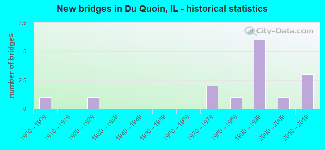
- New bridges - historical statistics
- 11900-1909
- 11920-1929
- 21970-1979
- 11980-1989
- 61990-1999
- 12000-2009
- 32010-2019

- Reconstructed bridges - Historical Statistics
- 11940-1949
- 01950-1959
- 01960-1969
- 11970-1979


- Bridge Condition - Deck
- 25.0%Good
- 33.3%Satisfactory
- 33.3%Fair
- 8.3%Serious

- Bridge Condition - Superstructure
- 15.4%Very good
- 23.1%Good
- 15.4%Satisfactory
- 38.5%Fair
- 7.7%Serious

- Bridge Condition - Substructure
- 61.5%Very good
- 7.7%Good
- 7.7%Satisfactory
- 23.1%Fair

- Bridge Condition - Channel
- 8.3%Excellent
- 83.3%Very good
- 8.3%Good
Find on map >> Show street view
Structure Number: 730003, Location: S OF ILL 14 (Lat: 37.965128, Lng: -89.233708), Route carried "on" structure: US 51, Year Built: 1921, Year Reconstructed: 1954, Status: Posted for load, Structure Length: 0.79m (2.59ft), Average Daily Traffic: 6,600 (year 2021), Truck Traffic: 8%, Average Future Daily Traffic: 6,953 (year 2032), Design Load: H 20, Features Intersected: HALF-MILE CREEK
Minimum Vertical Clearance: 30+ m (98+ ft), Kilometerpoint: 116.063, Lanes on structure: 2, Base Highway Network: Yes, Owner: State Highway Agency, Approaching Roadway Width: 7.3m (24.0ft), Material/Design: Concrete, Design/Construction: Slab, Number Of Spans In Main Unit: 1, Length of Maximum Span: 7.6m (24.9ft), Curb-To-Curb Width: 11.9m (39.0ft), Out-to-Out Width: 12.9m (42.3ft)
Condition: Deck: Fair, Superstructure: Fair, Substructure: Fair, Channel: Very good, Operating Rating: 46.3 metric tons, Method Used To Determine Operating Rating: Load Factor (LF) rating reported by rating factor (RF) method using MS18 loading, Inventory Rating: 27.9 metric tons, Method Used To Determine Inventory Rating: Load Factor (LF) rating reported by rating factor (RF) method using MS18 loading, Structural Evaluation: Somewhat better than minimum adequacy, Deck Geometry: Somewhat better than minimum adequacy, Waterway Adequacy: Equal to present desirable criteria, Approach Roadway Alignment: Equal to present desirable criteria, Bridge Posting: Required (Relationship of Operating Rating to Maximum Legal Load: 30.0 - 39.9% below), Designated Inspection Frequency: Every 12 months, Inspection Date: August 2021, Deck Structure Type: Concrete Cast-file-Place, Wearing Surface/Protective System: Wearing Surface: Other
Find on map >> Show street view
Structure Number: 730033, Location: NEAR DOWNTWN DUQUOIN (Lat: 38.009972, Lng: -89.241553), Route carried "on" structure: US 51, Year Built: 1997, Status: Open, Structure Length: 24.57m (80.61ft), Average Daily Traffic: 4,350 (year 2021), Truck Traffic: 8%, Average Future Daily Traffic: 5,820 (year 2032), Design Load: HS 20, Features Intersected: CHSTNT-ICG-OAK-ALLEY
Minimum Vertical Clearance: 30+ m (98+ ft), Kilometerpoint: 121.293, Lanes on structure: 2, Lanes under structure: 4, Base Highway Network: Yes, Owner: State Highway Agency, Approaching Roadway Width: 9.8m (32.2ft), Material/Design: Prestressed concrete continuous, Design/Construction: Stringer/Multi-beam, Number Of Spans In Main Unit: 15, Length of Maximum Span: 19.8m (65.0ft), Curb-To-Curb Width: 9.1m (29.9ft), Out-to-Out Width: 10.1m (33.1ft)
Condition: Deck: Satisfactory, Superstructure: Fair, Substructure: Good, Operating Rating: 64.2 metric tons, Method Used To Determine Operating Rating: Load and Resistance Factor Rating (LRFR) rating reported by rating factor(RF) method using HL-93 loadings, Inventory Rating: 38.6 metric tons, Method Used To Determine Inventory Rating: Load and Resistance Factor Rating (LRFR) rating reported by rating factor(RF) method using HL-93 loadings, Structural Evaluation: Somewhat better than minimum adequacy, Deck Geometry: Meets minimum limits, Underclear: Somewhat better than minimum adequacy, Approach Roadway Alignment: Equal to present desirable criteria, Designated Inspection Frequency: Every 24 months, Inspection Date: January 2022, Deck Structure Type: Concrete Cast-file-Place, Wearing Surface/Protective System: Deck Protection: Epoxy Coated Reinforcing
Find on map >> Show street view
Structure Number: 730036, Location: 3.7mi E of US 51 (Lat: 37.975881, Lng: -89.167814), Route carried "on" structure: State highway 14, Year Built: 2012, Status: Open, Structure Length: 3.54m (11.61ft), Average Daily Traffic: 3,500 (year 2021), Truck Traffic: 14%, Average Future Daily Traffic: 4,500 (year 2032), Design Load: HS 25 or greater, Features Intersected: Reese Creek
Minimum Vertical Clearance: 30+ m (98+ ft), Kilometerpoint: 5.890, Lanes on structure: 2, Base Highway Network: Yes, Owner: State Highway Agency, Approaching Roadway Width: 11.0m (36.1ft), Material/Design: Steel, Design/Construction: Stringer/Multi-beam, Number Of Spans In Main Unit: 1, Length of Maximum Span: 34.6m (113.5ft), Curb-To-Curb Width: 11.0m (36.1ft), Out-to-Out Width: 11.9m (39.0ft)
Condition: Deck: Satisfactory, Superstructure: Very good, Substructure: Very good, Channel: Excellent, Operating Rating: 92.0 metric tons, Method Used To Determine Operating Rating: Load Factor (LF) rating reported by rating factor (RF) method using MS18 loading, Inventory Rating: 55.1 metric tons, Method Used To Determine Inventory Rating: Load Factor (LF) rating reported by rating factor (RF) method using MS18 loading, Structural Evaluation: Equal to present desirable criteria, Deck Geometry: Somewhat better than minimum adequacy, Waterway Adequacy: Superior to present desirable criteria, Approach Roadway Alignment: Equal to present desirable criteria, Designated Inspection Frequency: Every 24 months, Inspection Date: July 2020, Deck Structure Type: Concrete Cast-file-Place, Wearing Surface/Protective System: Deck Protection: Epoxy Coated Reinforcing
Find on map >> Show street view
Structure Number: 733027, Location: 1 MI W OF US 51 (Lat: 37.972589, Lng: -89.247258), Route carried "on" structure: County highway , Year Built: 1900, Year Reconstructed: 1977, Status: Open, Structure Length: 0.91m (2.99ft), Average Daily Traffic: 1,000 (year 2019), Truck Traffic: 8%, Average Future Daily Traffic: 1,082 (year 2032), Design Load: HS 20, Features Intersected: SIXMILE CREEK, Facility Carried by Structure: FAS-1824 (CH-27)
Minimum Vertical Clearance: 30+ m (98+ ft), Kilometerpoint: 5.729, Lanes on structure: 2, Owner: County Highway Agency, Approaching Roadway Width: 7.3m (24.0ft), Skew: 4 degrees, Material/Design: Concrete, Design/Construction: Channel Beam, Number Of Spans In Main Unit: 1, Length of Maximum Span: 8.8m (28.9ft), Curb-To-Curb Width: 7.8m (25.6ft), Out-to-Out Width: 8.0m (26.2ft)
Condition: Deck: Serious, Superstructure: Serious, Substructure: Fair, Channel: Very good, Operating Rating: 52.8 metric tons, Method Used To Determine Operating Rating: Load Factor (LF) rating reported by rating factor (RF) method using MS18 loading, Inventory Rating: 31.8 metric tons, Method Used To Determine Inventory Rating: Load Factor (LF) rating reported by rating factor (RF) method using MS18 loading, Structural Evaluation: High priority of corrective action, Deck Geometry: Meets minimum limits, Waterway Adequacy: Equal to present desirable criteria, Approach Roadway Alignment: Somewhat better than minimum adequacy, Designated Inspection Frequency: Every 24 months, Other Special Inspection Frequency: Every 12 months, Inspection Date: January 2021, Other Special Inspection Date: January 2022, Deck Structure Type: Concrete Precast Panels, Wearing Surface/Protective System: Wearing Surface: Bituminous
Find on map >> Show street view
Structure Number: 7331, Location: 0.8 MI N. FAS 865 (Lat: 38.022592, Lng: -89.215225), Route carried "on" structure: County highway , Year Built: 1977, Status: Open, Structure Length: 1.22m (4.00ft), Average Daily Traffic: 400 (year 2019), Truck Traffic: 4%, Average Future Daily Traffic: 309 (year 2032), Design Load: HS 20, Features Intersected: REESE CREEK, Facility Carried by Structure: TR 268
Minimum Vertical Clearance: 30+ m (98+ ft), Kilometerpoint: 1.786, Lanes on structure: 2, Owner: Town or Township Highway Agency, Approaching Roadway Width: 6.1m (20.0ft), Material/Design: Concrete, Design/Construction: Tee Beam, Number Of Spans In Main Unit: 1, Length of Maximum Span: 11.3m (37.1ft), Curb-To-Curb Width: 6.7m (22.0ft), Out-to-Out Width: 6.9m (22.6ft)
Condition: Deck: Good, Superstructure: Good, Substructure: Very good, Channel: Good, Operating Rating: 44.4 metric tons, Method Used To Determine Operating Rating: Assigned rating based on Load Factor Design (LFD) reported by rating factor (RF) using MS18 loading, Inventory Rating: 32.4 metric tons, Method Used To Determine Inventory Rating: Assigned rating based on Load Factor Design (LFD) reported by rating factor (RF) using MS18 loading, Structural Evaluation: Better than present minimum criteria, Deck Geometry: Meets minimum limits, Waterway Adequacy: Equal to present minimum criteria, Approach Roadway Alignment: Better than present minimum criteria, Designated Inspection Frequency: Every 48 months, Inspection Date: January 2019, Deck Structure Type: Concrete Precast Panels, Wearing Surface/Protective System: Wearing Surface: Gravel
Find on map >> Show street view
Structure Number: 733105, Location: 0.9 MI E FAS 865 (Lat: 38.012892, Lng: -89.184172), Route carried "on" structure: County highway , Year Built: 1977, Status: Open, Structure Length: 1.01m (3.31ft), Average Daily Traffic: 1,050 (year 2019), Truck Traffic: 7%, Average Future Daily Traffic: 1,185 (year 2032), Design Load: HS 20, Features Intersected: REESE CREEK, Facility Carried by Structure: CH 7
Minimum Vertical Clearance: 30+ m (98+ ft), Kilometerpoint: 2.301, Lanes on structure: 2, Owner: County Highway Agency, Approaching Roadway Width: 10.4m (34.1ft), Material/Design: Concrete, Design/Construction: Tee Beam, Number Of Spans In Main Unit: 1, Length of Maximum Span: 9.4m (30.8ft), Curb-To-Curb Width: 8.6m (28.2ft), Out-to-Out Width: 9.0m (29.5ft)
Condition: Deck: Fair, Superstructure: Fair, Substructure: Fair, Channel: Very good, Operating Rating: 44.4 metric tons, Method Used To Determine Operating Rating: Assigned rating based on Load Factor Design (LFD) reported by rating factor (RF) using MS18 loading, Inventory Rating: 32.4 metric tons, Method Used To Determine Inventory Rating: Assigned rating based on Load Factor Design (LFD) reported by rating factor (RF) using MS18 loading, Structural Evaluation: Somewhat better than minimum adequacy, Deck Geometry: Somewhat better than minimum adequacy, Waterway Adequacy: Equal to present desirable criteria, Approach Roadway Alignment: Better than present minimum criteria, Designated Inspection Frequency: Every 24 months, Inspection Date: January 2022, Deck Structure Type: Concrete Precast Panels, Wearing Surface/Protective System: Wearing Surface: Bituminous
Find on map >> Show street view
Structure Number: 733149, Location: 0.2 MI N OF ILL 4 (Lat: 37.974919, Lng: -89.194361), Route carried "on" structure: County highway , Year Built: 1989, Status: Open, Structure Length: 1.99m (6.53ft), Average Daily Traffic: 950 (year 2019), Truck Traffic: 8%, Average Future Daily Traffic: 1,030 (year 2032), Design Load: HS 20, Features Intersected: BLACKSOP CREEK, Facility Carried by Structure: CO HWY 2
Minimum Vertical Clearance: 30+ m (98+ ft), Kilometerpoint: 1.883, Lanes on structure: 2, Owner: County Highway Agency, Approaching Roadway Width: 9.1m (29.9ft), Material/Design: Prestressed concrete, Design/Construction: Box Beam or Girders - Multiple, Number Of Spans In Main Unit: 1, Length of Maximum Span: 19.1m (62.7ft), Curb-To-Curb Width: 8.6m (28.2ft), Out-to-Out Width: 8.6m (28.2ft)
Condition: Deck: Satisfactory, Superstructure: Satisfactory, Substructure: Very good, Channel: Very good, Operating Rating: 44.4 metric tons, Method Used To Determine Operating Rating: Assigned rating based on Load Factor Design (LFD) reported by rating factor (RF) using MS18 loading, Inventory Rating: 32.4 metric tons, Method Used To Determine Inventory Rating: Assigned rating based on Load Factor Design (LFD) reported by rating factor (RF) using MS18 loading, Structural Evaluation: Equal to present minimum criteria, Deck Geometry: Somewhat better than minimum adequacy, Waterway Adequacy: Better than present minimum criteria, Approach Roadway Alignment: Superior to present desirable criteria, Designated Inspection Frequency: Every 24 months, Inspection Date: January 2022, Deck Structure Type: Concrete Precast Panels, Wearing Surface/Protective System: Wearing Surface: Bituminous
Find on map >> Show street view
Structure Number: 733155, Location: 2 MI E OF DUQUOIN (Lat: 38.001897, Lng: -89.195567), Route carried "on" structure: County highway , Year Built: 1994, Status: Open, Structure Length: 0.78m (2.56ft), Average Daily Traffic: 25 (year 2019), Truck Traffic: 32%, Average Future Daily Traffic: 77 (year 2032), Design Load: HS 20, Features Intersected: SLOUGH, Facility Carried by Structure: TR 255
Minimum Vertical Clearance: 30+ m (98+ ft), Kilometerpoint: 0.354, Lanes on structure: 2, Owner: Town or Township Highway Agency, Approaching Roadway Width: 6.1m (20.0ft), Material/Design: Concrete, Design/Construction: Frame, Number Of Spans In Main Unit: 1, Length of Maximum Span: 7.5m (24.6ft), Curb-To-Curb Width: 7.3m (24.0ft), Out-to-Out Width: 8.0m (26.2ft)
Condition: Superstructure: Very good, Substructure: Very good, Channel: Very good, Operating Rating: 44.1 metric tons, Method Used To Determine Operating Rating: Assigned rating based on Load Factor Design (LFD) reported by rating factor (RF) using MS18 loading, Inventory Rating: 32.4 metric tons, Method Used To Determine Inventory Rating: Assigned rating based on Load Factor Design (LFD) reported by rating factor (RF) using MS18 loading, Structural Evaluation: Equal to present desirable criteria, Deck Geometry: Equal to present minimum criteria, Waterway Adequacy: Better than present minimum criteria, Approach Roadway Alignment: Equal to present desirable criteria, Designated Inspection Frequency: Every 48 months, Inspection Date: January 2020, Wearing Surface/Protective System: Wearing Surface: Gravel
Find on map >> Show street view
Structure Number: 733166, Location: 0.27 MI E TR 182C (Lat: 38.016581, Lng: -89.316133), Route carried "on" structure: County highway , Year Built: 1999, Status: Open, Structure Length: 1.27m (4.17ft), Average Daily Traffic: 175 (year 2019), Truck Traffic: 13%, Average Future Daily Traffic: 258 (year 2032), Design Load: HS 20, Features Intersected: WILLIAM CREEK, Facility Carried by Structure: TR241-SACREDHEART
Minimum Vertical Clearance: 30+ m (98+ ft), Kilometerpoint: 0.435, Lanes on structure: 2, Owner: Town or Township Highway Agency, Approaching Roadway Width: 6.1m (20.0ft), Skew: 1 degrees, Material/Design: Prestressed concrete, Design/Construction: Box Beam or Girders - Multiple, Number Of Spans In Main Unit: 1, Length of Maximum Span: 11.9m (39.0ft), Curb-To-Curb Width: 7.4m (24.3ft), Out-to-Out Width: 7.4m (24.3ft)
Condition: Deck: Fair, Superstructure: Fair, Substructure: Satisfactory, Channel: Very good, Operating Rating: 44.1 metric tons, Method Used To Determine Operating Rating: Assigned rating based on Load Factor Design (LFD) reported by rating factor (RF) using MS18 loading, Inventory Rating: 32.4 metric tons, Method Used To Determine Inventory Rating: Assigned rating based on Load Factor Design (LFD) reported by rating factor (RF) using MS18 loading, Structural Evaluation: Somewhat better than minimum adequacy, Deck Geometry: Somewhat better than minimum adequacy, Waterway Adequacy: Equal to present desirable criteria, Approach Roadway Alignment: Superior to present desirable criteria, Designated Inspection Frequency: Every 24 months, Inspection Date: January 2022, Deck Structure Type: Concrete Precast Panels, Wearing Surface/Protective System: Wearing Surface: Gravel
Find on map >> Show street view
Structure Number: 733167, Location: 0.7 MI N OF IL 152 (Lat: 38.012492, Lng: -89.320361), Route carried "on" structure: County highway , Year Built: 1999, Status: Open, Structure Length: 1.56m (5.12ft), Average Daily Traffic: 25 (year 2019), Truck Traffic: 16%, Average Future Daily Traffic: 52 (year 2032), Design Load: HS 20, Features Intersected: WILLIAM CREEK, Facility Carried by Structure: TR 182C-CUDGETOWN
Minimum Vertical Clearance: 30+ m (98+ ft), Kilometerpoint: 5.101, Lanes on structure: 2, Owner: Town or Township Highway Agency, Approaching Roadway Width: 6.1m (20.0ft), Material/Design: Prestressed concrete, Design/Construction: Box Beam or Girders - Multiple, Number Of Spans In Main Unit: 1, Length of Maximum Span: 14.9m (48.9ft), Curb-To-Curb Width: 7.4m (24.3ft), Out-to-Out Width: 7.4m (24.3ft)
Condition: Deck: Fair, Superstructure: Fair, Substructure: Very good, Channel: Very good, Operating Rating: 44.1 metric tons, Method Used To Determine Operating Rating: Assigned rating based on Load Factor Design (LFD) reported by rating factor (RF) using MS18 loading, Inventory Rating: 32.4 metric tons, Method Used To Determine Inventory Rating: Assigned rating based on Load Factor Design (LFD) reported by rating factor (RF) using MS18 loading, Structural Evaluation: Somewhat better than minimum adequacy, Deck Geometry: Equal to present minimum criteria, Waterway Adequacy: Equal to present desirable criteria, Approach Roadway Alignment: Better than present minimum criteria, Designated Inspection Frequency: Every 24 months, Inspection Date: January 2022, Deck Structure Type: Concrete Precast Panels, Wearing Surface/Protective System: Wearing Surface: Gravel
Find on map >> Show street view
Structure Number: 733185, Location: 1.5M E US51 ST JOHNS (Lat: 38.038950, Lng: -89.201350), Route carried "on" structure: County highway , Year Built: 2012, Status: Open, Structure Length: 1.32m (4.33ft), Average Daily Traffic: 75 (year 2019), Truck Traffic: 4%, Average Future Daily Traffic: 100 (year 2037), Design Load: HS 25 or greater, Features Intersected: REESE CREEK TRIB, Facility Carried by Structure: SASSAFRAS RD
Minimum Vertical Clearance: 30+ m (98+ ft), Kilometerpoint: 2.671, Lanes on structure: 2, Owner: Town or Township Highway Agency, Approaching Roadway Width: 5.5m (18.0ft), Skew: 1 degrees, Material/Design: Prestressed concrete, Design/Construction: Box Beam or Girders - Multiple, Number Of Spans In Main Unit: 1, Length of Maximum Span: 12.4m (40.7ft), Curb-To-Curb Width: 7.3m (24.0ft), Out-to-Out Width: 7.3m (24.0ft)
Condition: Deck: Satisfactory, Superstructure: Satisfactory, Substructure: Very good, Channel: Very good, Operating Rating: 42.1 metric tons, Method Used To Determine Operating Rating: Assigned ratings based on Load and Resistance Factor Design (LRFD) reported by rating factor (RF) using HL93 loadings, Inventory Rating: 32.4 metric tons, Method Used To Determine Inventory Rating: Assigned ratings based on Load and Resistance Factor Design (LRFD) reported by rating factor (RF) using HL93 loadings, Structural Evaluation: Equal to present minimum criteria, Deck Geometry: Equal to present minimum criteria, Waterway Adequacy: Superior to present desirable criteria, Approach Roadway Alignment: Equal to present desirable criteria, Designated Inspection Frequency: Every 24 months, Inspection Date: January 2021, Deck Structure Type: Concrete Precast Panels, Wearing Surface/Protective System: Wearing Surface: Gravel
Find on map >> Show street view
Structure Number: 733186, Location: 1.0 MI NE OF DUQUOIN (Lat: 38.038489, Lng: -89.194000), Route carried "on" structure: County highway , Year Built: 2009, Status: Open, Structure Length: 1.40m (4.59ft), Average Daily Traffic: 75 (year 2019), Truck Traffic: 4%, Average Future Daily Traffic: 77 (year 2032), Design Load: HS 20, Features Intersected: UNNAMED CREEK, Facility Carried by Structure: SASSAFRAS RD
Minimum Vertical Clearance: 30+ m (98+ ft), Kilometerpoint: 3.331, Lanes on structure: 2, Owner: Town or Township Highway Agency, Approaching Roadway Width: 5.5m (18.0ft), Skew: 2 degrees, Material/Design: Prestressed concrete, Design/Construction: Box Beam or Girders - Multiple, Number Of Spans In Main Unit: 1, Length of Maximum Span: 13.2m (43.3ft), Curb-To-Curb Width: 7.3m (24.0ft), Out-to-Out Width: 7.3m (24.0ft)
Condition: Deck: Good, Superstructure: Good, Substructure: Very good, Channel: Very good, Operating Rating: 44.1 metric tons, Method Used To Determine Operating Rating: Assigned rating based on Load Factor Design (LFD) reported by rating factor (RF) using MS18 loading, Inventory Rating: 32.4 metric tons, Method Used To Determine Inventory Rating: Assigned rating based on Load Factor Design (LFD) reported by rating factor (RF) using MS18 loading, Structural Evaluation: Better than present minimum criteria, Deck Geometry: Equal to present minimum criteria, Waterway Adequacy: Superior to present desirable criteria, Approach Roadway Alignment: Superior to present desirable criteria, Designated Inspection Frequency: Every 48 months, Inspection Date: January 2019, Deck Structure Type: Concrete Precast Panels, Wearing Surface/Protective System: Wearing Surface: Gravel
Find on map >> Show street view
Structure Number: 733187, Location: T5S R1W SEC 34 (Lat: 38.044003, Lng: -89.201228), Route carried "on" structure: County highway , Year Built: 2016, Status: Open, Structure Length: 1.48m (4.86ft), Average Daily Traffic: 275 (year 2019), Truck Traffic: 10%, Average Future Daily Traffic: 350 (year 2039), Design Load: HS 25 or greater, Features Intersected: Reese Creel Trib., Facility Carried by Structure: TR-292 (Pecan Road
Minimum Vertical Clearance: 30+ m (98+ ft), Kilometerpoint: 3.058, Lanes on structure: 2, Owner: Town or Township Highway Agency, Approaching Roadway Width: 5.5m (18.0ft), Skew: 3 degrees, Material/Design: Prestressed concrete, Design/Construction: Box Beam or Girders - Multiple, Number Of Spans In Main Unit: 1, Length of Maximum Span: 13.9m (45.6ft), Curb-To-Curb Width: 7.3m (24.0ft), Out-to-Out Width: 7.3m (24.0ft)
Condition: Deck: Good, Superstructure: Good, Substructure: Very good, Channel: Very good, Operating Rating: 42.1 metric tons, Method Used To Determine Operating Rating: Assigned ratings based on Load and Resistance Factor Design (LRFD) reported by rating factor (RF) using HL93 loadings, Inventory Rating: 32.4 metric tons, Method Used To Determine Inventory Rating: Assigned ratings based on Load and Resistance Factor Design (LRFD) reported by rating factor (RF) using HL93 loadings, Structural Evaluation: Better than present minimum criteria, Deck Geometry: Somewhat better than minimum adequacy, Waterway Adequacy: Equal to present desirable criteria, Approach Roadway Alignment: Better than present minimum criteria, Designated Inspection Frequency: Every 48 months, Inspection Date: March 2020, Deck Structure Type: Concrete Precast Panels, Wearing Surface/Protective System: Wearing Surface: Gravel
Find on map >> Show street view
Structure Number: 730033, Location: NEAR DOWNTWN DUQUOIN (Lat: 38.010139, Lng: -89.239358), Route carried "under" structure: City street , Year Built: 1997, Structure Length: 0. m, Average Daily Traffic: 375 (year 2014), Truck Traffic: 8%, Features Intersected: CHSTNT-ICG-OAK-ALLEY, Facility Carried by Structure: US 51-FAP322
Minimum Vertical Clearance: 6.30m (20.67ft), Kilometerpoint: 1.159, Lanes on structure: 2, Lanes under structure: 2, Material/Design: Prestressed concrete continuous, Design/Construction: Stringer/Multi-beam, Length of Maximum Span: 19.8m (65.0ft)
Find on map >> Show street view
Structure Number: 730033, Location: NEAR DOWNTWN DUQUOIN (Lat: 38.010150, Lng: -89.240256), Route carried "under" structure: City street , Year Built: 1997, Structure Length: 0. m, Average Daily Traffic: 250 (year 2014), Truck Traffic: 24%, Features Intersected: CHSTNT-ICG-OAK-ALLEY, Facility Carried by Structure: US 51-FAP322
Minimum Vertical Clearance: 7.87m (25.82ft), Kilometerpoint: 1.271, Lanes on structure: 2, Lanes under structure: 2, Material/Design: Prestressed concrete continuous, Design/Construction: Stringer/Multi-beam, Length of Maximum Span: 19.8m (65.0ft)