Bridge Statistics for Drakesboro, Kentucky (KY)
Condition, Traffic, Stress, Structural Evaluation, Project Costs
- National Bridge Inventory (NBI) Statistics
- 10Number of bridges
- 121ft / 37.1mTotal length
- $1,497,000Total costs
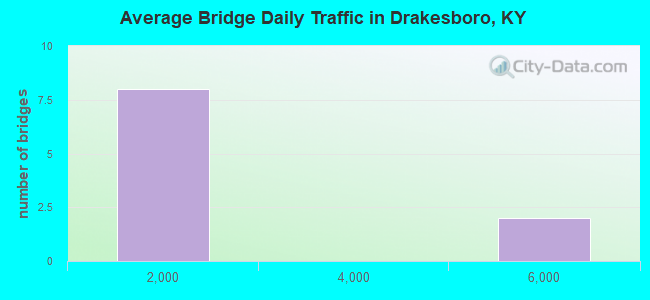
- 17,404Total average daily traffic
- 1,736Total average daily truck traffic
- National Bridge Inventory (NBI) Registered Bridges for Drakesboro
- No street view available for this location
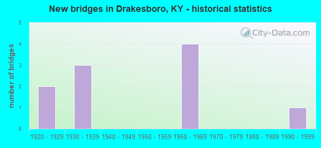
- New bridges - historical statistics
- 21920-1929
- 31930-1939
- 41960-1969
- 11990-1999
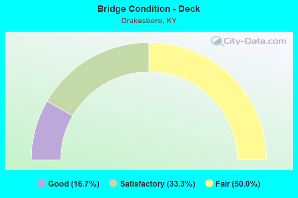
- Bridge Condition - Deck
- 16.7%Good
- 33.3%Satisfactory
- 50.0%Fair
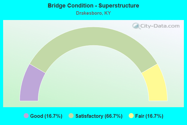
- Bridge Condition - Superstructure
- 16.7%Good
- 66.7%Satisfactory
- 16.7%Fair
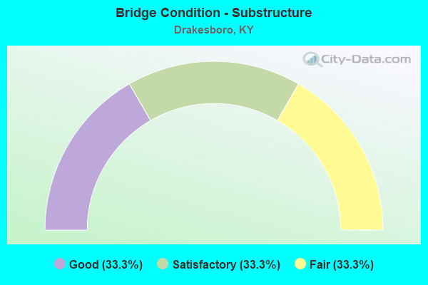
- Bridge Condition - Substructure
- 33.3%Good
- 33.3%Satisfactory
- 33.3%Fair
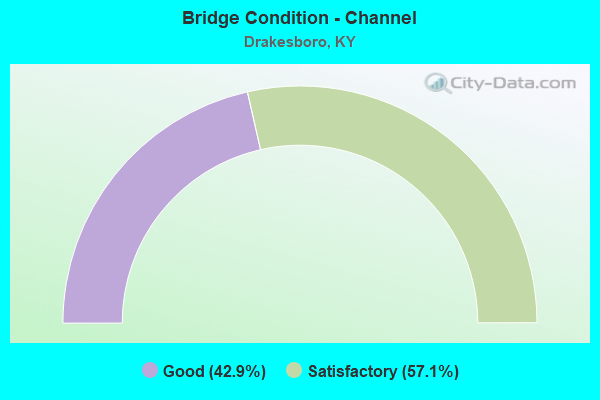
- Bridge Condition - Channel
- 42.9%Good
- 57.1%Satisfactory
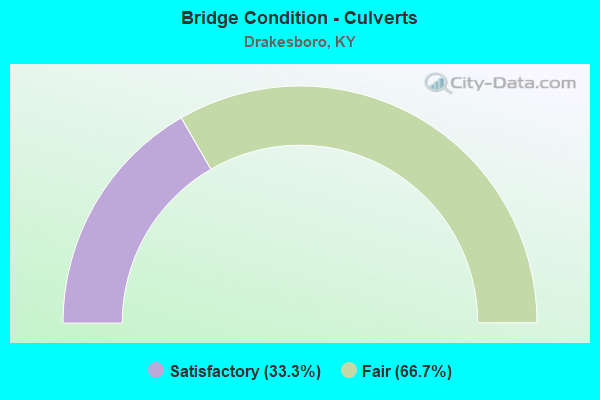
- Bridge Condition - Culverts
- 33.3%Satisfactory
- 66.7%Fair
Find on map >> Show street view
Structure Number: 89B00010N, Location: .05 MI N.E. OF JCT US 431 (Lat: 37.228611, Lng: -87.051944), Route carried "on" structure: State highway 2107, Year Built: 1929, Status: Open, Structure Length: 1.62m (5.31ft), Average Daily Traffic: 241 (year 2020), Average Future Daily Traffic: 209 (year 2040), Design Load: H 15, Features Intersected: CSX RAILROAD
Minimum Vertical Clearance: 30+ m (98+ ft), Kilometerpoint: 0.414, Lanes on structure: 2, Owner: State Highway Agency, Approaching Roadway Width: 5.5m (18.0ft), Material/Design: Concrete, Design/Construction: Tee Beam, Number Of Spans In Main Unit: 1, Length of Maximum Span: 15.2m (49.9ft), Curb or Sidewalk Widths: Left: 0.5m (1.6ft), Right: 0.5m (1.6ft), Curb-To-Curb Width: 5.8m (19.0ft), Out-to-Out Width: 6.7m (22.0ft)
Condition: Deck: Fair, Superstructure: Satisfactory, Substructure: Satisfactory, Operating Rating: 58.7 metric tons, Method Used To Determine Operating Rating: Load Factor (LF), Inventory Rating: 35.2 metric tons, Method Used To Determine Inventory Rating: Load Factor (LF), Structural Evaluation: Equal to present minimum criteria, Deck Geometry: High priority of corrective action, Underclear: Somewhat better than minimum adequacy, Approach Roadway Alignment: Equal to present minimum criteria, Length Of Structure Improvement: 0.16m (0.52ft), Designated Inspection Frequency: Every 24 months, Inspection Date: September 2021, Bridge Improvement Cost: $132,000, Total Project Cost: $132,000, Deck Structure Type: Concrete Cast-file-Place, Wearing Surface/Protective System: Wearing Surface: Low Slump Concrete
Find on map >> Show street view
Structure Number: 89B00012N, Location: .50 MI N.E. OF JCT US 431 (Lat: 37.232222, Lng: -87.053056), Route carried "on" structure: State highway 2107, Year Built: 1928, Status: Open, Structure Length: 11.28m (37.01ft), Average Daily Traffic: 241 (year 2020), Average Future Daily Traffic: 209 (year 2040), Design Load: H 15, Features Intersected: POND CREEK
Minimum Vertical Clearance: 30+ m (98+ ft), Kilometerpoint: 0.961, Lanes on structure: 2, Owner: State Highway Agency, Approaching Roadway Width: 5.5m (18.0ft), Material/Design: Concrete, Design/Construction: Tee Beam, Number Of Spans In Main Unit: 7, Length of Maximum Span: 15.2m (49.9ft), Curb or Sidewalk Widths: Left: 0.4m (1.3ft), Right: 0.4m (1.3ft), Curb-To-Curb Width: 5.8m (19.0ft), Out-to-Out Width: 6.7m (22.0ft)
Condition: Deck: Satisfactory, Superstructure: Fair, Substructure: Fair, Channel: Satisfactory, Operating Rating: 49.0 metric tons, Method Used To Determine Operating Rating: Load Factor (LF), Inventory Rating: 29.4 metric tons, Method Used To Determine Inventory Rating: Load Factor (LF), Structural Evaluation: Somewhat better than minimum adequacy, Deck Geometry: High priority of corrective action, Waterway Adequacy: Equal to present minimum criteria, Approach Roadway Alignment: Equal to present desirable criteria, Length Of Structure Improvement: 1.13m (3.71ft), Designated Inspection Frequency: Every 24 months, Inspection Date: September 2021, Bridge Improvement Cost: $925,000, Total Project Cost: $925,000, Deck Structure Type: Concrete Cast-file-Place, Wearing Surface/Protective System: Wearing Surface: Low Slump Concrete
Find on map >> Show street view
Structure Number: 89B00022N, Location: .65 MI E OF JCT KY 246 (Lat: 37.208889, Lng: -87.070278), Route carried "on" structure: State highway 176, Year Built: 1932, Status: Open, Structure Length: 0.79m (2.59ft), Average Daily Traffic: 1,724 (year 2018), Truck Traffic: 6%, Average Future Daily Traffic: 1,517 (year 2038), Design Load: H 15, Features Intersected: BR OF POND CREEK
Minimum Vertical Clearance: 30+ m (98+ ft), Kilometerpoint: 10.277, Lanes on structure: 2, Owner: State Highway Agency, Approaching Roadway Width: 5.5m (18.0ft), Skew: 3 degrees, Material/Design: Concrete, Design/Construction: Culvert, Number Of Spans In Main Unit: 2, Length of Maximum Span: 3.7m (12.1ft)
Condition: Channel: Good, Culverts: Fair, Operating Rating: 63.8 metric tons, Method Used To Determine Operating Rating: Load Factor (LF), Inventory Rating: 38.2 metric tons, Method Used To Determine Inventory Rating: Load Factor (LF), Structural Evaluation: Somewhat better than minimum adequacy, Waterway Adequacy: Better than present minimum criteria, Approach Roadway Alignment: Equal to present desirable criteria, Designated Inspection Frequency: Every 24 months, Inspection Date: September 2021
Find on map >> Show street view
Structure Number: 89B00023N, Location: .5 MI EAST OF JCT. US 431 (Lat: 37.223056, Lng: -87.038333), Route carried "on" structure: State highway 176, Year Built: 1964, Status: Open, Structure Length: 3.93m (12.89ft), Average Daily Traffic: 1,345 (year 2019), Average Future Daily Traffic: 1,170 (year 2039), Design Load: H 20, Features Intersected: PLUM CREEK
Minimum Vertical Clearance: 30+ m (98+ ft), Kilometerpoint: 13.633, Lanes on structure: 2, Owner: State Highway Agency, Approaching Roadway Width: 6.7m (22.0ft), Material/Design: Concrete, Design/Construction: Tee Beam, Number Of Spans In Main Unit: 3, Length of Maximum Span: 12.2m (40.0ft), Curb or Sidewalk Widths: Left: 0.9m (3.0ft), Right: 0.9m (3.0ft), Curb-To-Curb Width: 8.5m (27.9ft), Out-to-Out Width: 10.3m (33.8ft)
Condition: Deck: Fair, Superstructure: Satisfactory, Substructure: Satisfactory, Channel: Good, Operating Rating: 81.6 metric tons, Method Used To Determine Operating Rating: Load Factor (LF), Inventory Rating: 49.0 metric tons, Method Used To Determine Inventory Rating: Load Factor (LF), Structural Evaluation: Equal to present minimum criteria, Deck Geometry: Somewhat better than minimum adequacy, Waterway Adequacy: Better than present minimum criteria, Approach Roadway Alignment: Better than present minimum criteria, Designated Inspection Frequency: Every 24 months, Inspection Date: September 2021, Deck Structure Type: Concrete Cast-file-Place, Wearing Surface/Protective System: Wearing Surface: Low Slump Concrete
Find on map >> Show street view
Structure Number: 89B00025N, Location: 1.0 MI EAST OF JCT US 431 (Lat: 37.204444, Lng: -87.020556), Route carried "on" structure: State highway 70, Year Built: 1933, Status: Open, Structure Length: 0.73m (2.40ft), Average Daily Traffic: 1,446 (year 2019), Truck Traffic: 7%, Average Future Daily Traffic: 1,272 (year 2039), Design Load: H 15, Features Intersected: UNNAME STREAM
Minimum Vertical Clearance: 30+ m (98+ ft), Kilometerpoint: 25.344, Lanes on structure: 2, Owner: State Highway Agency, Approaching Roadway Width: 7.5m (24.6ft), Skew: 1 degrees, Material/Design: Concrete, Design/Construction: Culvert, Number Of Spans In Main Unit: 2, Length of Maximum Span: 3.0m (9.8ft)
Condition: Channel: Satisfactory, Culverts: Satisfactory, Operating Rating: 54.4 metric tons, Method Used To Determine Operating Rating: Field evaluation and documented engineering judgment, Inventory Rating: 40.8 metric tons, Method Used To Determine Inventory Rating: Field evaluation and documented engineering judgment, Structural Evaluation: Equal to present minimum criteria, Waterway Adequacy: Better than present minimum criteria, Approach Roadway Alignment: Better than present minimum criteria, Designated Inspection Frequency: Every 24 months, Inspection Date: September 2021
Find on map >> Show street view
Structure Number: 89B00099N, Location: .60 MI SOU. OF JCT KY 176 (Lat: 37.212222, Lng: -87.044167), Route carried "on" structure: US 431, Year Built: 1930, Status: Open, Structure Length: 1.19m (3.90ft), Average Daily Traffic: 5,440 (year 2019), Truck Traffic: 13%, Average Future Daily Traffic: 4,515 (year 2039), Design Load: H 15, Features Intersected: PLUM CRK
Minimum Vertical Clearance: 30+ m (98+ ft), Kilometerpoint: 17.696, Lanes on structure: 2, Base Highway Network: Yes, Owner: State Highway Agency, Approaching Roadway Width: 6.7m (22.0ft), Skew: 3 degrees, Material/Design: Concrete, Design/Construction: Culvert, Number Of Spans In Main Unit: 3, Length of Maximum Span: 3.7m (12.1ft)
Condition: Channel: Good, Culverts: Fair, Operating Rating: 46.9 metric tons, Method Used To Determine Operating Rating: Load Factor (LF), Inventory Rating: 28.1 metric tons, Method Used To Determine Inventory Rating: Load Factor (LF), Structural Evaluation: Somewhat better than minimum adequacy, Waterway Adequacy: Better than present minimum criteria, Approach Roadway Alignment: Better than present minimum criteria, Designated Inspection Frequency: Every 24 months, Inspection Date: September 2021, Bridge Improvement Cost: $200,000, Roadway Improvement Cost: $30,000, Total Project Cost: $305,000
Find on map >> Show street view
Structure Number: 89B00135N, Location: 1.0 MI. N JCT KY 176 (Lat: 37.229167, Lng: -87.057222), Route carried "on" structure: US 431, Year Built: 1999, Status: Open, Structure Length: 8.84m (29.00ft), Average Daily Traffic: 5,162 (year 2020), Truck Traffic: 16%, Average Future Daily Traffic: 4,284 (year 2040), Design Load: HS 25 or greater, Features Intersected: POND CREEK
Minimum Vertical Clearance: 30+ m (98+ ft), Kilometerpoint: 20.057, Lanes on structure: 2, Base Highway Network: Yes, Owner: State Highway Agency, Approaching Roadway Width: 12.8m (42.0ft), Skew: 4 degrees, Material/Design: Prestressed concrete continuous, Design/Construction: Stringer/Multi-beam, Number Of Spans In Main Unit: 3, Number Of Approach Spans: 2, Length of Maximum Span: 35.1m (115.2ft), Curb-To-Curb Width: 13.4m (44.0ft), Out-to-Out Width: 14.3m (46.9ft)
Condition: Deck: Satisfactory, Superstructure: Good, Substructure: Good, Channel: Satisfactory, Operating Rating: 70.2 metric tons, Method Used To Determine Operating Rating: Load Factor (LF), Inventory Rating: 42.1 metric tons, Method Used To Determine Inventory Rating: Load Factor (LF), Structural Evaluation: Better than present minimum criteria, Deck Geometry: Equal to present minimum criteria, Waterway Adequacy: Equal to present desirable criteria, Approach Roadway Alignment: Equal to present desirable criteria, Designated Inspection Frequency: Every 24 months, Inspection Date: September 2021, Deck Structure Type: Concrete Cast-file-Place, Wearing Surface/Protective System: Wearing Surface: Monolithic Concrete, Deck Protection: Epoxy Coated Reinforcing
Find on map >> Show street view
Structure Number: 89B00140N, Location: 2.0 MI W of JCT KY 176 (Lat: 37.244722, Lng: -87.051389), Route carried "on" structure: State lands road 1141, Year Built: 1965, Status: Open, Structure Length: 6.89m (22.60ft), Average Daily Traffic: 100 (year 2016), Average Future Daily Traffic: 100 (year 2036), Features Intersected: Pond Creek, Facility Carried by Structure: P and M Haul Rd
Minimum Vertical Clearance: 30+ m (98+ ft), Kilometerpoint: 2.781, Lanes on structure: 2, Owner: State Agenciy, Approaching Roadway Width: 11.6m (38.1ft), Skew: 2 degrees, Material/Design: Steel, Design/Construction: Stringer/Multi-beam, Number Of Spans In Main Unit: 8, Length of Maximum Span: 12.6m (41.3ft), Curb or Sidewalk Widths: Left: 0.3m (1.0ft), Right: 0.3m (1.0ft), Curb-To-Curb Width: 7.5m (24.6ft), Out-to-Out Width: 8.1m (26.6ft)
Condition: Deck: Fair, Superstructure: Satisfactory, Substructure: Fair, Channel: Satisfactory, Operating Rating: 99.8 metric tons, Method Used To Determine Operating Rating: Load Factor (LF), Inventory Rating: 92.9 metric tons, Method Used To Determine Inventory Rating: Load Factor (LF), Structural Evaluation: Somewhat better than minimum adequacy, Deck Geometry: Equal to present minimum criteria, Waterway Adequacy: Better than present minimum criteria, Approach Roadway Alignment: Equal to present desirable criteria, Designated Inspection Frequency: Every 24 months, Inspection Date: September 2021, Deck Structure Type: Concrete Cast-file-Place, Wearing Surface/Protective System: Wearing Surface: Monolithic Concrete
Find on map >> Show street view
Structure Number: 89X00902N, Location: 2.5 MI E OF JCT KY 2107 (Lat: 37.250556, Lng: -87.021111), Route carried "on" structure: State lands road 1141, Year Built: 1960, Status: Open, Structure Length: 1.83m (6.00ft), Average Daily Traffic: 100 (year 2014), Average Future Daily Traffic: 2,034 (year 2034), Features Intersected: KY 176, Facility Carried by Structure: P AND M HAUL RD
Minimum Vertical Clearance: 30+ m (98+ ft), Kilometerpoint: 5.597, Lanes on structure: 2, Lanes under structure: 2, Owner: Private, Approaching Roadway Width: 5.5m (18.0ft), Skew: 3 degrees, Material/Design: Steel, Design/Construction: Stringer/Multi-beam, Number Of Spans In Main Unit: 1, Length of Maximum Span: 17.4m (57.1ft), Curb-To-Curb Width: 5.5m (18.0ft), Out-to-Out Width: 5.5m (18.0ft)
Condition: Deck: Good, Superstructure: Satisfactory, Substructure: Good, Operating Rating: 99.8 metric tons, Method Used To Determine Operating Rating: Load Factor (LF), Inventory Rating: 96.9 metric tons, Method Used To Determine Inventory Rating: Load Factor (LF), Structural Evaluation: Equal to present minimum criteria, Deck Geometry: Meets minimum limits, Underclear: Superior to present desirable criteria, Approach Roadway Alignment: Equal to present desirable criteria, Length Of Structure Improvement: 0.18m (0.59ft), Designated Inspection Frequency: Every 24 months, Inspection Date: September 2021, Bridge Improvement Cost: $135,000, Total Project Cost: $135,000, Deck Structure Type: Concrete Cast-file-Place
Find on map >> Show street view
Structure Number: 89X00902N, Location: 2.5 MI E OF JCT KY 2107 (Lat: 37.250556, Lng: -87.021111), Route carried "under" structure: State highway 176, Year Built: 1960, Structure Length: 0. m, Average Daily Traffic: 1,605 (year 2017), Features Intersected: KY 176, Facility Carried by Structure: P AND M HAUL RD
Minimum Vertical Clearance: 30+ m (98+ ft), Kilometerpoint: 17.270, Lanes on structure: 2, Lanes under structure: 2, Material/Design: Steel, Design/Construction: Stringer/Multi-beam, Length of Maximum Span: 17.4m (57.1ft)