Bridge Statistics for Downs, Illinois (IL)
Condition, Traffic, Stress, Structural Evaluation, Project Costs
- National Bridge Inventory (NBI) Statistics
- 31Number of bridges
- 295ft / 89.8mTotal length
- $1,136,000Total costs
- 152,075Total average daily traffic
- 51,836Total average daily truck traffic
- National Bridge Inventory (NBI) Registered Bridges for Downs
- No street view available for this location
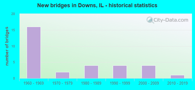
- New bridges - historical statistics
- 161960-1969
- 21970-1979
- 41980-1989
- 41990-1999
- 42000-2009
- 12010-2019


- Bridge Condition - Deck
- 15.0%Very good
- 55.0%Good
- 20.0%Satisfactory
- 10.0%Poor

- Bridge Condition - Superstructure
- 35.0%Very good
- 50.0%Good
- 15.0%Satisfactory

- Bridge Condition - Substructure
- 25.0%Very good
- 50.0%Good
- 10.0%Satisfactory
- 15.0%Fair

- Bridge Condition - Channel
- 13.0%Very good
- 60.9%Good
- 26.1%Satisfactory

- Bridge Condition - Culverts
- 85.7%Good
- 14.3%Fair
Find on map >> Show street view
Structure Number: 570123, Location: 3.53 MI E OF US 51 (Lat: 40.414597, Lng: -88.932156), Route carried "on" structure: County highway , Year Built: 1968, Status: Open, Structure Length: 8.34m (27.36ft), Average Daily Traffic: 450 (year 2020), Truck Traffic: 2%, Average Future Daily Traffic: 363 (year 2032), Design Load: HS 15, Features Intersected: I-74/SE OF BLOOMNGTN, Facility Carried by Structure: TR 296
Minimum Vertical Clearance: 30+ m (98+ ft), Kilometerpoint: 1.143, Lanes on structure: 2, Lanes under structure: 4, Owner: State Highway Agency, Approaching Roadway Width: 5.5m (18.0ft), Skew: 3 degrees, Material/Design: Steel continuous, Design/Construction: Stringer/Multi-beam, Number Of Spans In Main Unit: 4, Length of Maximum Span: 25.4m (83.3ft), Curb-To-Curb Width: 8.1m (26.6ft), Out-to-Out Width: 9.1m (29.9ft)
Condition: Deck: Good, Superstructure: Good, Substructure: Good, Operating Rating: 47.6 metric tons, Method Used To Determine Operating Rating: Allowable Stress (AS) rating reported by rating factor (RF) method using MS18 loading, Inventory Rating: 27.9 metric tons, Method Used To Determine Inventory Rating: Allowable Stress (AS) rating reported by rating factor (RF) method using MS18 loading, Structural Evaluation: Better than present minimum criteria, Deck Geometry: Somewhat better than minimum adequacy, Underclear: Meets minimum limits, Approach Roadway Alignment: Better than present minimum criteria, Designated Inspection Frequency: Every 24 months, Inspection Date: August 2020, Deck Structure Type: Concrete Cast-file-Place
Find on map >> Show street view
Structure Number: 570124, Location: 5.39 MI E OF US 51 (Lat: 40.400500, Lng: -88.901289), Route carried "on" structure: Other road , Year Built: 1968, Status: Open, Structure Length: 8.14m (26.71ft), Average Daily Traffic: 775 (year 2020), Truck Traffic: 10%, Average Future Daily Traffic: 1,564 (year 2032), Design Load: HS 15, Features Intersected: I-74/SE OF BLOOMNGTN, Facility Carried by Structure: FAU 6431 CH 29
Minimum Vertical Clearance: 30+ m (98+ ft), Kilometerpoint: 19.843, Lanes on structure: 2, Lanes under structure: 4, Owner: State Highway Agency, Approaching Roadway Width: 7.3m (24.0ft), Skew: 3 degrees, Material/Design: Steel continuous, Design/Construction: Stringer/Multi-beam, Number Of Spans In Main Unit: 4, Length of Maximum Span: 24.9m (81.7ft), Curb-To-Curb Width: 8.1m (26.6ft), Out-to-Out Width: 9.1m (29.9ft)
Condition: Deck: Poor, Superstructure: Good, Substructure: Good, Operating Rating: 46.0 metric tons, Method Used To Determine Operating Rating: Allowable Stress (AS) rating reported by rating factor (RF) method using MS18 loading, Inventory Rating: 29.8 metric tons, Method Used To Determine Inventory Rating: Allowable Stress (AS) rating reported by rating factor (RF) method using MS18 loading, Structural Evaluation: Better than present minimum criteria, Deck Geometry: Somewhat better than minimum adequacy, Underclear: Meets minimum limits, Approach Roadway Alignment: Equal to present desirable criteria, Designated Inspection Frequency: Every 24 months, Inspection Date: August 2020, Deck Structure Type: Concrete Cast-file-Place
Find on map >> Show street view
Structure Number: 570126, Location: 5.93 MI E OF US 51 (Lat: 40.396603, Lng: -88.892144), Route carried "on" structure: Interstate 74, Year Built: 1968, Year Reconstructed: 2007, Status: Open, Structure Length: 5.84m (19.16ft), Average Daily Traffic: 9,150 (year 2021), Truck Traffic: 41%, Average Future Daily Traffic: 9,606 (year 2032), Design Load: HS 20+Mod, Features Intersected: KICKAPOO CR
Minimum Vertical Clearance: 30+ m (98+ ft), Kilometerpoint: 230.613, Lanes on structure: 2, Base Highway Network: Yes, Owner: State Highway Agency, Approaching Roadway Width: 12.2m (40.0ft), Material/Design: Steel continuous, Design/Construction: Stringer/Multi-beam, Number Of Spans In Main Unit: 3, Length of Maximum Span: 21.0m (68.9ft), Curb-To-Curb Width: 12.2m (40.0ft), Out-to-Out Width: 13.2m (43.3ft)
Condition: Deck: Satisfactory, Superstructure: Very good, Substructure: Good, Channel: Satisfactory, Operating Rating: 89.1 metric tons, Method Used To Determine Operating Rating: Load Factor (LF) rating reported by rating factor (RF) method using MS18 loading, Inventory Rating: 78.1 metric tons, Method Used To Determine Inventory Rating: Load Factor (LF) rating reported by rating factor (RF) method using MS18 loading, Structural Evaluation: Better than present minimum criteria, Deck Geometry: Better than present minimum criteria, Waterway Adequacy: Equal to present desirable criteria, Approach Roadway Alignment: Equal to present desirable criteria, Length Of Structure Improvement: 5.85m (19.19ft), Designated Inspection Frequency: Every 24 months, Inspection Date: July 2021, Bridge Improvement Cost: $483,000, Roadway Improvement Cost: $48,000, Total Project Cost: $725,000, Deck Structure Type: Concrete Cast-file-Place, Wearing Surface/Protective System: Deck Protection: Epoxy Coated Reinforcing
Find on map >> Show street view
Structure Number: 570127, Location: 6.91 MI E OF US 51 (Lat: 40.389503, Lng: -88.875531), Route carried "on" structure: Other road , Year Built: 1968, Status: Open, Structure Length: 7.04m (23.10ft), Average Daily Traffic: 2,100 (year 2020), Truck Traffic: 12%, Average Future Daily Traffic: 4,859 (year 2032), Design Load: HS 20, Features Intersected: I-74 NEAR DOWNS, Facility Carried by Structure: FAU 6437 CH 36
Minimum Vertical Clearance: 30+ m (98+ ft), Kilometerpoint: 2.366, Lanes on structure: 2, Lanes under structure: 4, Base Highway Network: Yes, Owner: State Highway Agency, Approaching Roadway Width: 13.4m (44.0ft), Skew: 30 degrees, Material/Design: Steel continuous, Design/Construction: Stringer/Multi-beam, Number Of Spans In Main Unit: 4, Length of Maximum Span: 21.6m (70.9ft), Curb-To-Curb Width: 11.7m (38.4ft), Out-to-Out Width: 17.7m (58.1ft)
Condition: Deck: Poor, Superstructure: Satisfactory, Substructure: Satisfactory, Operating Rating: 60.3 metric tons, Method Used To Determine Operating Rating: Allowable Stress (AS) rating reported by rating factor (RF) method using MS18 loading, Inventory Rating: 40.2 metric tons, Method Used To Determine Inventory Rating: Allowable Stress (AS) rating reported by rating factor (RF) method using MS18 loading, Structural Evaluation: Equal to present minimum criteria, Deck Geometry: Somewhat better than minimum adequacy, Underclear: High priority of corrective action, Approach Roadway Alignment: Equal to present desirable criteria, Designated Inspection Frequency: Every 24 months, Inspection Date: August 2020, Deck Structure Type: Concrete Cast-file-Place, Wearing Surface/Protective System: Wearing Surface: Bituminous, Membrane: Built-up
Find on map >> Show street view
Structure Number: 570128, Location: 7.6 MI E OF US 51 (Lat: 40.384422, Lng: -88.863589), Route carried "on" structure: Interstate 74, Year Built: 1968, Status: Open, Structure Length: 3.34m (10.96ft), Average Daily Traffic: 10,750 (year 2021), Truck Traffic: 37%, Average Future Daily Traffic: 10,891 (year 2032), Design Load: HS 20+Mod, Features Intersected: LITTLE KICKAPOO CR
Minimum Vertical Clearance: 30+ m (98+ ft), Kilometerpoint: 233.268, Lanes on structure: 2, Base Highway Network: Yes, Owner: State Highway Agency, Approaching Roadway Width: 12.2m (40.0ft), Skew: 2 degrees, Material/Design: Prestressed concrete continuous, Design/Construction: Stringer/Multi-beam, Number Of Spans In Main Unit: 2, Length of Maximum Span: 15.8m (51.8ft), Curb-To-Curb Width: 11.7m (38.4ft), Out-to-Out Width: 12.8m (42.0ft)
Condition: Deck: Satisfactory, Superstructure: Satisfactory, Substructure: Satisfactory, Channel: Good, Operating Rating: 77.8 metric tons, Method Used To Determine Operating Rating: Load Factor (LF) rating reported by rating factor (RF) method using MS18 loading, Inventory Rating: 48.0 metric tons, Method Used To Determine Inventory Rating: Load Factor (LF) rating reported by rating factor (RF) method using MS18 loading, Structural Evaluation: Equal to present minimum criteria, Deck Geometry: Equal to present minimum criteria, Waterway Adequacy: Equal to present desirable criteria, Approach Roadway Alignment: Equal to present desirable criteria, Length Of Structure Improvement: 3.32m (10.89ft), Designated Inspection Frequency: Every 24 months, Inspection Date: August 2020, Bridge Improvement Cost: $274,000, Roadway Improvement Cost: $27,000, Total Project Cost: $411,000, Deck Structure Type: Concrete Cast-file-Place, Wearing Surface/Protective System: Wearing Surface: Other
Find on map >> Show street view
Structure Number: 570129, Location: 7.6 MI E OF US 51 (Lat: 40.384353, Lng: -88.863428), Route carried "on" structure: Interstate 74, Year Built: 1968, Year Reconstructed: 2009, Status: Open, Structure Length: 3.34m (10.96ft), Average Daily Traffic: 10,750 (year 2021), Truck Traffic: 37%, Average Future Daily Traffic: 10,891 (year 2032), Design Load: HS 20+Mod, Features Intersected: LITTLE KICKAPOO CR
Minimum Vertical Clearance: 30+ m (98+ ft), Kilometerpoint: 233.284, Lanes on structure: 2, Base Highway Network: Yes, Owner: State Highway Agency, Approaching Roadway Width: 12.2m (40.0ft), Skew: 2 degrees, Material/Design: Prestressed concrete continuous, Design/Construction: Stringer/Multi-beam, Number Of Spans In Main Unit: 2, Length of Maximum Span: 15.8m (51.8ft), Curb-To-Curb Width: 12.2m (40.0ft), Out-to-Out Width: 13.2m (43.3ft)
Condition: Deck: Good, Superstructure: Very good, Substructure: Good, Channel: Good, Operating Rating: 71.6 metric tons, Method Used To Determine Operating Rating: Load Factor (LF) rating reported by rating factor (RF) method using MS18 loading, Inventory Rating: 43.1 metric tons, Method Used To Determine Inventory Rating: Load Factor (LF) rating reported by rating factor (RF) method using MS18 loading, Structural Evaluation: Better than present minimum criteria, Deck Geometry: Better than present minimum criteria, Waterway Adequacy: Equal to present desirable criteria, Approach Roadway Alignment: Equal to present desirable criteria, Designated Inspection Frequency: Every 24 months, Inspection Date: August 2020, Deck Structure Type: Concrete Cast-file-Place, Wearing Surface/Protective System: Deck Protection: Epoxy Coated Reinforcing
Find on map >> Show street view
Structure Number: 57013, Location: 8.87 MI E OF US 51 (Lat: 40.375161, Lng: -88.843450), Route carried "on" structure: County highway , Year Built: 1968, Status: Open, Structure Length: 8.20m (26.90ft), Average Daily Traffic: 75 (year 2020), Truck Traffic: 1%, Average Future Daily Traffic: 112 (year 2032), Design Load: HS 15, Features Intersected: I-74, Facility Carried by Structure: TR 366A
Minimum Vertical Clearance: 30+ m (98+ ft), Kilometerpoint: 1.062, Lanes on structure: 2, Lanes under structure: 4, Owner: State Highway Agency, Approaching Roadway Width: 6.4m (21.0ft), Skew: 3 degrees, Material/Design: Steel continuous, Design/Construction: Stringer/Multi-beam, Number Of Spans In Main Unit: 4, Length of Maximum Span: 25.3m (83.0ft), Curb-To-Curb Width: 8.1m (26.6ft), Out-to-Out Width: 9.1m (29.9ft)
Condition: Deck: Satisfactory, Superstructure: Good, Substructure: Good, Operating Rating: 42.4 metric tons, Method Used To Determine Operating Rating: Allowable Stress (AS) rating reported by rating factor (RF) method using MS18 loading, Inventory Rating: 27.2 metric tons, Method Used To Determine Inventory Rating: Allowable Stress (AS) rating reported by rating factor (RF) method using MS18 loading, Structural Evaluation: Equal to present minimum criteria, Deck Geometry: Equal to present minimum criteria, Underclear: Meets minimum limits, Approach Roadway Alignment: Better than present minimum criteria, Designated Inspection Frequency: Every 24 months, Inspection Date: August 2020, Deck Structure Type: Concrete Cast-file-Place
Find on map >> Show street view
Structure Number: 570246, Location: DOWNS-NW OF (Lat: 40.401294, Lng: -88.872439), Route carried "on" structure: US 150, Year Built: 2009, Status: Open, Structure Length: 4.50m (14.76ft), Average Daily Traffic: 7,100 (year 2021), Truck Traffic: 6%, Average Future Daily Traffic: 8,992 (year 2032), Design Load: HS 20, Features Intersected: KICKAPOO CREEK
Minimum Vertical Clearance: 30+ m (98+ ft), Kilometerpoint: 232.431, Lanes on structure: 2, Base Highway Network: Yes, Owner: State Highway Agency, Approaching Roadway Width: 9.8m (32.2ft), Material/Design: Steel continuous, Design/Construction: Stringer/Multi-beam, Number Of Spans In Main Unit: 3, Length of Maximum Span: 18.3m (60.0ft), Curb-To-Curb Width: 12.2m (40.0ft), Out-to-Out Width: 13.2m (43.3ft)
Condition: Deck: Good, Superstructure: Very good, Substructure: Very good, Channel: Satisfactory, Operating Rating: 78.4 metric tons, Method Used To Determine Operating Rating: Load Factor (LF) rating reported by rating factor (RF) method using MS18 loading, Inventory Rating: 47.0 metric tons, Method Used To Determine Inventory Rating: Load Factor (LF) rating reported by rating factor (RF) method using MS18 loading, Structural Evaluation: Equal to present desirable criteria, Deck Geometry: Somewhat better than minimum adequacy, Waterway Adequacy: Equal to present desirable criteria, Approach Roadway Alignment: Better than present minimum criteria, Designated Inspection Frequency: Every 48 months, Inspection Date: October 2018, Deck Structure Type: Concrete Cast-file-Place, Wearing Surface/Protective System: Deck Protection: Epoxy Coated Reinforcing
Find on map >> Show street view
Structure Number: 572033, Location: 10.39 M E OF BS51 (Lat: 40.364633, Lng: -88.820925), Route carried "on" structure: Interstate 74, Year Built: 1969, Status: Open, Structure Length: 0.76m (2.49ft), Average Daily Traffic: 21,500 (year 2021), Truck Traffic: 37%, Average Future Daily Traffic: 21,782 (year 2032), Design Load: HS 20, Features Intersected: DRAINAGE DITCH
Minimum Vertical Clearance: 30+ m (98+ ft), Kilometerpoint: 237.565, Lanes on structure: 4, Base Highway Network: Yes, Owner: State Highway Agency, Approaching Roadway Width: 24.4m (80.1ft), Skew: 3 degrees, Material/Design: Concrete continuous, Design/Construction: Culvert, Number Of Spans In Main Unit: 2, Length of Maximum Span: 3.7m (12.1ft)
Condition: Channel: Very good, Culverts: Fair, Operating Rating: 51.8 metric tons, Method Used To Determine Operating Rating: Load Factor (LF) rating reported by rating factor (RF) method using MS18 loading, Inventory Rating: 31.1 metric tons, Method Used To Determine Inventory Rating: Load Factor (LF) rating reported by rating factor (RF) method using MS18 loading, Structural Evaluation: Somewhat better than minimum adequacy, Waterway Adequacy: Equal to present desirable criteria, Approach Roadway Alignment: Equal to present desirable criteria, Designated Inspection Frequency: Every 24 months, Inspection Date: August 2020
Find on map >> Show street view
Structure Number: 572034, Location: 5.1 MI N OF LEROY (Lat: 40.388556, Lng: -88.848511), Route carried "on" structure: US 150, Year Built: 1997, Status: Open, Structure Length: 0.86m (2.82ft), Average Daily Traffic: 4,200 (year 2021), Truck Traffic: 5%, Average Future Daily Traffic: 5,417 (year 2032), Design Load: HS 20, Features Intersected: KICKAPOO CREEK
Minimum Vertical Clearance: 30+ m (98+ ft), Kilometerpoint: 234.974, Lanes on structure: 2, Owner: State Highway Agency, Approaching Roadway Width: 9.8m (32.2ft), Material/Design: Concrete, Design/Construction: Culvert, Number Of Spans In Main Unit: 2, Length of Maximum Span: 4.0m (13.1ft)
Condition: Channel: Good, Culverts: Good, Operating Rating: 59.0 metric tons, Method Used To Determine Operating Rating: Load Factor (LF) rating reported by rating factor (RF) method using MS18 loading, Inventory Rating: 35.6 metric tons, Method Used To Determine Inventory Rating: Load Factor (LF) rating reported by rating factor (RF) method using MS18 loading, Structural Evaluation: Better than present minimum criteria, Waterway Adequacy: Equal to present desirable criteria, Approach Roadway Alignment: Equal to present desirable criteria, Designated Inspection Frequency: Every 48 months, Inspection Date: October 2018
Find on map >> Show street view
Structure Number: 573415, Location: 4.3 MI W DOWNS (Lat: 40.400339, Lng: -88.951975), Route carried "on" structure: County highway , Year Built: 1968, Status: Open, Structure Length: 2.28m (7.48ft), Average Daily Traffic: 75 (year 2020), Average Future Daily Traffic: 88 (year 2032), Design Load: HS 15, Features Intersected: LITTLE KICKAPOO CR, Facility Carried by Structure: TR 433
Minimum Vertical Clearance: 30+ m (98+ ft), Kilometerpoint: 2.929, Lanes on structure: 2, Owner: Town or Township Highway Agency, Approaching Roadway Width: 4.9m (16.1ft), Material/Design: Concrete continuous, Design/Construction: Slab, Number Of Spans In Main Unit: 3, Length of Maximum Span: 8.5m (27.9ft), Curb-To-Curb Width: 7.3m (24.0ft), Out-to-Out Width: 8.2m (26.9ft)
Condition: Deck: Good, Superstructure: Good, Substructure: Fair, Channel: Good, Operating Rating: 37.9 metric tons, Method Used To Determine Operating Rating: Allowable Stress (AS) rating reported by rating factor (RF) method using MS18 loading, Inventory Rating: 22.7 metric tons, Method Used To Determine Inventory Rating: Allowable Stress (AS) rating reported by rating factor (RF) method using MS18 loading, Structural Evaluation: Somewhat better than minimum adequacy, Deck Geometry: Equal to present minimum criteria, Waterway Adequacy: Equal to present desirable criteria, Approach Roadway Alignment: Equal to present desirable criteria, Designated Inspection Frequency: Every 24 months, Inspection Date: September 2021, Deck Structure Type: Concrete Cast-file-Place
Find on map >> Show street view
Structure Number: 574205, Location: 2.0 MI E DOWNS (Lat: 40.388394, Lng: -88.819814), Route carried "on" structure: County highway , Year Built: 1967, Status: Open, Structure Length: 1.03m (3.38ft), Average Daily Traffic: 75 (year 2020), Average Future Daily Traffic: 88 (year 2032), Design Load: HS 15, Features Intersected: LITTLE KICKAPOO CR, Facility Carried by Structure: TR 386
Minimum Vertical Clearance: 30+ m (98+ ft), Kilometerpoint: 1.223, Lanes on structure: 2, Owner: Town or Township Highway Agency, Approaching Roadway Width: 4.3m (14.1ft), Material/Design: Concrete, Design/Construction: Slab, Number Of Spans In Main Unit: 1, Length of Maximum Span: 9.5m (31.2ft), Curb-To-Curb Width: 7.3m (24.0ft), Out-to-Out Width: 7.9m (25.9ft)
Condition: Deck: Very good, Superstructure: Very good, Substructure: Fair, Channel: Satisfactory, Operating Rating: 52.8 metric tons, Method Used To Determine Operating Rating: Allowable Stress (AS) rating reported by rating factor (RF) method using MS18 loading, Inventory Rating: 31.8 metric tons, Method Used To Determine Inventory Rating: Allowable Stress (AS) rating reported by rating factor (RF) method using MS18 loading, Structural Evaluation: Somewhat better than minimum adequacy, Deck Geometry: Equal to present minimum criteria, Waterway Adequacy: Equal to present desirable criteria, Approach Roadway Alignment: Equal to present desirable criteria, Designated Inspection Frequency: Every 24 months, Inspection Date: September 2021, Deck Structure Type: Concrete Cast-file-Place
Find on map >> Show street view
Structure Number: 574216, Location: 2.2 MI SW DOWNS (Lat: 40.385247, Lng: -88.904358), Route carried "on" structure: County highway , Year Built: 1972, Status: Open, Structure Length: 4.27m (14.01ft), Average Daily Traffic: 200 (year 2020), Truck Traffic: 2%, Average Future Daily Traffic: 894 (year 2032), Design Load: HS 15, Features Intersected: KICKAPOO CKEEK, Facility Carried by Structure: FAS 1480 CH 36
Minimum Vertical Clearance: 30+ m (98+ ft), Kilometerpoint: 7.290, Lanes on structure: 2, Owner: County Highway Agency, Approaching Roadway Width: 6.7m (22.0ft), Skew: 3 degrees, Material/Design: Steel continuous, Design/Construction: Stringer/Multi-beam, Number Of Spans In Main Unit: 3, Length of Maximum Span: 15.2m (49.9ft), Curb-To-Curb Width: 8.5m (27.9ft), Out-to-Out Width: 9.1m (29.9ft)
Condition: Deck: Good, Superstructure: Good, Substructure: Fair, Channel: Satisfactory, Operating Rating: 48.3 metric tons, Method Used To Determine Operating Rating: Load Factor (LF) rating reported by rating factor (RF) method using MS18 loading, Inventory Rating: 28.8 metric tons, Method Used To Determine Inventory Rating: Load Factor (LF) rating reported by rating factor (RF) method using MS18 loading, Structural Evaluation: Somewhat better than minimum adequacy, Deck Geometry: Equal to present minimum criteria, Waterway Adequacy: Better than present minimum criteria, Approach Roadway Alignment: Equal to present desirable criteria, Designated Inspection Frequency: Every 24 months, Inspection Date: November 2020, Deck Structure Type: Concrete Cast-file-Place, Wearing Surface/Protective System: Wearing Surface: Other
Find on map >> Show street view
Structure Number: 574217, Location: 3.5 MI SW DOWNS (Lat: 40.367186, Lng: -88.921350), Route carried "on" structure: County highway , Year Built: 1973, Status: Open, Structure Length: 3.60m (11.81ft), Average Daily Traffic: 50 (year 2020), Average Future Daily Traffic: 66 (year 2032), Design Load: HS 15, Features Intersected: KICKAPOO CREEK, Facility Carried by Structure: TR-302
Minimum Vertical Clearance: 30+ m (98+ ft), Kilometerpoint: 2.044, Lanes on structure: 2, Owner: Town or Township Highway Agency, Approaching Roadway Width: 4.9m (16.1ft), Material/Design: Concrete continuous, Design/Construction: Slab, Number Of Spans In Main Unit: 3, Length of Maximum Span: 14.0m (45.9ft), Curb-To-Curb Width: 7.3m (24.0ft), Out-to-Out Width: 7.9m (25.9ft)
Condition: Deck: Good, Superstructure: Good, Substructure: Very good, Channel: Satisfactory, Operating Rating: 35.6 metric tons, Method Used To Determine Operating Rating: Allowable Stress (AS) rating reported by rating factor (RF) method using MS18 loading, Inventory Rating: 21.4 metric tons, Method Used To Determine Inventory Rating: Allowable Stress (AS) rating reported by rating factor (RF) method using MS18 loading, Structural Evaluation: Equal to present minimum criteria, Deck Geometry: Equal to present minimum criteria, Waterway Adequacy: Equal to present desirable criteria, Approach Roadway Alignment: Equal to present desirable criteria, Designated Inspection Frequency: Every 24 months, Inspection Date: September 2021, Deck Structure Type: Concrete Cast-file-Place
Find on map >> Show street view
Structure Number: 574219, Location: 0.5 MILE S DOWNS (Lat: 40.386089, Lng: -88.869364), Route carried "on" structure: County highway , Year Built: 1980, Status: Open, Structure Length: 2.35m (7.71ft), Average Daily Traffic: 575 (year 2020), Truck Traffic: 8%, Average Future Daily Traffic: 251 (year 2032), Design Load: HS 20, Features Intersected: LITTLE KICKAPOO CR, Facility Carried by Structure: CH 27
Minimum Vertical Clearance: 30+ m (98+ ft), Kilometerpoint: 0.805, Lanes on structure: 2, Owner: County Highway Agency, Approaching Roadway Width: 6.1m (20.0ft), Material/Design: Concrete continuous, Design/Construction: Slab, Number Of Spans In Main Unit: 3, Length of Maximum Span: 8.7m (28.5ft), Curb-To-Curb Width: 8.0m (26.2ft), Out-to-Out Width: 8.5m (27.9ft)
Condition: Deck: Very good, Superstructure: Very good, Substructure: Good, Channel: Good, Operating Rating: 75.8 metric tons, Method Used To Determine Operating Rating: Load Factor (LF) rating reported by rating factor (RF) method using MS18 loading, Inventory Rating: 45.7 metric tons, Method Used To Determine Inventory Rating: Load Factor (LF) rating reported by rating factor (RF) method using MS18 loading, Structural Evaluation: Better than present minimum criteria, Deck Geometry: Somewhat better than minimum adequacy, Waterway Adequacy: Equal to present desirable criteria, Approach Roadway Alignment: Equal to present desirable criteria, Designated Inspection Frequency: Every 48 months, Inspection Date: March 2018, Deck Structure Type: Concrete Cast-file-Place
Find on map >> Show street view
Structure Number: 57422, Location: 2.0 MI W DOWNS (Lat: 40.385178, Lng: -88.911306), Route carried "on" structure: County highway , Year Built: 1985, Status: Open, Structure Length: 0.78m (2.56ft), Average Daily Traffic: 200 (year 2020), Truck Traffic: 2%, Average Future Daily Traffic: 894 (year 2032), Design Load: HS 20, Features Intersected: LITTLE KICKAPOO CR, Facility Carried by Structure: FAS 1480 CH 36
Minimum Vertical Clearance: 30+ m (98+ ft), Kilometerpoint: 6.695, Lanes on structure: 2, Owner: County Highway Agency, Approaching Roadway Width: 6.7m (22.0ft), Material/Design: Concrete continuous, Design/Construction: Culvert, Number Of Spans In Main Unit: 2, Length of Maximum Span: 3.7m (12.1ft)
Condition: Channel: Good, Culverts: Good, Operating Rating: 53.8 metric tons, Method Used To Determine Operating Rating: Field evaluation and documented engineering judgment, Inventory Rating: 32.4 metric tons, Method Used To Determine Inventory Rating: Field evaluation and documented engineering judgment, Structural Evaluation: Better than present minimum criteria, Waterway Adequacy: Equal to present desirable criteria, Approach Roadway Alignment: Equal to present desirable criteria, Designated Inspection Frequency: Every 48 months, Inspection Date: November 2018
Find on map >> Show street view
Structure Number: 574221, Location: 1.0 MI NW DOWNS (Lat: 40.404950, Lng: -88.900872), Route carried "on" structure: Other road , Year Built: 1987, Status: Open, Structure Length: 0.67m (2.20ft), Average Daily Traffic: 775 (year 2020), Truck Traffic: 10%, Average Future Daily Traffic: 1,564 (year 2032), Design Load: HS 20, Features Intersected: LITTLE KICKAPOO CR, Facility Carried by Structure: FAU 6431 CH 29
Minimum Vertical Clearance: 30+ m (98+ ft), Kilometerpoint: 19.344, Lanes on structure: 2, Owner: County Highway Agency, Approaching Roadway Width: 11.0m (36.1ft), Material/Design: Concrete continuous, Design/Construction: Culvert, Number Of Spans In Main Unit: 2, Length of Maximum Span: 3.0m (9.8ft)
Condition: Channel: Good, Culverts: Good, Operating Rating: 97.2 metric tons, Method Used To Determine Operating Rating: Load Factor (LF) rating reported by rating factor (RF) method using MS18 loading, Inventory Rating: 73.9 metric tons, Method Used To Determine Inventory Rating: Load Factor (LF) rating reported by rating factor (RF) method using MS18 loading, Structural Evaluation: Better than present minimum criteria, Waterway Adequacy: Equal to present desirable criteria, Approach Roadway Alignment: Equal to present desirable criteria, Designated Inspection Frequency: Every 48 months, Inspection Date: March 2020, Wearing Surface/Protective System: Wearing Surface: Bituminous
Find on map >> Show street view
Structure Number: 574222, Location: 3 MI SW DOWNS (Lat: 40.356478, Lng: -88.921147), Route carried "on" structure: County highway , Year Built: 1991, Status: Open, Structure Length: 2.16m (7.09ft), Average Daily Traffic: 50 (year 2020), Average Future Daily Traffic: 66 (year 2032), Design Load: HS 20, Features Intersected: LITTLE KICKAPOO CR, Facility Carried by Structure: TR 302
Minimum Vertical Clearance: 30+ m (98+ ft), Kilometerpoint: 3.235, Lanes on structure: 2, Owner: Town or Township Highway Agency, Approaching Roadway Width: 4.9m (16.1ft), Material/Design: Concrete continuous, Design/Construction: Slab, Number Of Spans In Main Unit: 3, Length of Maximum Span: 8.0m (26.2ft), Curb-To-Curb Width: 7.9m (25.9ft), Out-to-Out Width: 8.2m (26.9ft)
Condition: Deck: Good, Superstructure: Good, Substructure: Good, Channel: Good, Operating Rating: 44.1 metric tons, Method Used To Determine Operating Rating: Assigned rating based on Load Factor Design (LFD) reported by rating factor (RF) using MS18 loading, Inventory Rating: 32.4 metric tons, Method Used To Determine Inventory Rating: Assigned rating based on Load Factor Design (LFD) reported by rating factor (RF) using MS18 loading, Structural Evaluation: Better than present minimum criteria, Deck Geometry: Equal to present minimum criteria, Waterway Adequacy: Better than present minimum criteria, Approach Roadway Alignment: Equal to present minimum criteria, Designated Inspection Frequency: Every 48 months, Inspection Date: September 2019, Deck Structure Type: Concrete Cast-file-Place, Wearing Surface/Protective System: Deck Protection: Epoxy Coated Reinforcing
Find on map >> Show street view
Structure Number: 574223, Location: 3.0 MI SW DOWNS (Lat: 40.355556, Lng: -88.825000), Route carried "on" structure: County highway , Year Built: 1994, Status: Open, Structure Length: 0.79m (2.59ft), Average Daily Traffic: 50 (year 2020), Average Future Daily Traffic: 66 (year 2032), Design Load: HS 20, Features Intersected: BR SALT CK, Facility Carried by Structure: TR 501
Minimum Vertical Clearance: 30+ m (98+ ft), Kilometerpoint: 6.437, Lanes on structure: 2, Owner: Town or Township Highway Agency, Approaching Roadway Width: 4.9m (16.1ft), Material/Design: Concrete, Design/Construction: Culvert, Number Of Spans In Main Unit: 2, Length of Maximum Span: 3.9m (12.8ft)
Condition: Channel: Good, Culverts: Good, Operating Rating: 44.1 metric tons, Method Used To Determine Operating Rating: Assigned rating based on Load Factor Design (LFD) reported by rating factor (RF) using MS18 loading, Inventory Rating: 32.4 metric tons, Method Used To Determine Inventory Rating: Assigned rating based on Load Factor Design (LFD) reported by rating factor (RF) using MS18 loading, Structural Evaluation: Better than present minimum criteria, Waterway Adequacy: Equal to present desirable criteria, Approach Roadway Alignment: Equal to present desirable criteria, Designated Inspection Frequency: Every 48 months, Inspection Date: Febuary 2022
Find on map >> Show street view
Structure Number: 574224, Location: 2.2 MI SW DOWNS (Lat: 40.378033, Lng: -88.900875), Route carried "on" structure: Other road , Year Built: 1999, Status: Open, Structure Length: 2.95m (9.68ft), Average Daily Traffic: 1,350 (year 2020), Truck Traffic: 3%, Average Future Daily Traffic: 1,173 (year 2032), Design Load: HS 20, Features Intersected: LITTLE KICKAPOO CR, Facility Carried by Structure: FAU 6431 CH 29
Minimum Vertical Clearance: 30+ m (98+ ft), Kilometerpoint: 22.337, Lanes on structure: 2, Owner: County Highway Agency, Approaching Roadway Width: 11.0m (36.1ft), Material/Design: Concrete continuous, Design/Construction: Slab, Number Of Spans In Main Unit: 3, Length of Maximum Span: 11.1m (36.4ft), Curb-To-Curb Width: 9.8m (32.2ft), Out-to-Out Width: 9.8m (32.2ft)
Condition: Deck: Good, Superstructure: Good, Substructure: Very good, Channel: Very good, Operating Rating: 69.3 metric tons, Method Used To Determine Operating Rating: Load Factor (LF) rating reported by rating factor (RF) method using MS18 loading, Inventory Rating: 41.5 metric tons, Method Used To Determine Inventory Rating: Load Factor (LF) rating reported by rating factor (RF) method using MS18 loading, Structural Evaluation: Better than present minimum criteria, Deck Geometry: Somewhat better than minimum adequacy, Waterway Adequacy: Equal to present desirable criteria, Approach Roadway Alignment: Equal to present desirable criteria, Designated Inspection Frequency: Every 48 months, Inspection Date: March 2020, Deck Structure Type: Concrete Cast-file-Place, Wearing Surface/Protective System: Deck Protection: Epoxy Coated Reinforcing
Find on map >> Show street view
Structure Number: 574225, Location: 3.5 MI SSE DOWNS (Lat: 40.336067, Lng: -88.862022), Route carried "on" structure: County highway , Year Built: 2000, Status: Open, Structure Length: 0.80m (2.62ft), Average Daily Traffic: 125 (year 2020), Truck Traffic: 3%, Average Future Daily Traffic: 140 (year 2032), Design Load: HS 20, Features Intersected: WEST FORK SALT CREEK, Facility Carried by Structure: CH 27
Minimum Vertical Clearance: 30+ m (98+ ft), Kilometerpoint: 6.807, Lanes on structure: 2, Owner: County Highway Agency, Approaching Roadway Width: 10.4m (34.1ft), Material/Design: Concrete, Design/Construction: Culvert, Number Of Spans In Main Unit: 2, Length of Maximum Span: 3.7m (12.1ft), Curb-To-Curb Width: 10.4m (34.1ft), Out-to-Out Width: 11.0m (36.1ft)
Condition: Channel: Good, Culverts: Good, Operating Rating: 44.1 metric tons, Method Used To Determine Operating Rating: Assigned rating based on Load Factor Design (LFD) reported by rating factor (RF) using MS18 loading, Inventory Rating: 32.4 metric tons, Method Used To Determine Inventory Rating: Assigned rating based on Load Factor Design (LFD) reported by rating factor (RF) using MS18 loading, Structural Evaluation: Better than present minimum criteria, Deck Geometry: Better than present minimum criteria, Waterway Adequacy: Equal to present desirable criteria, Approach Roadway Alignment: Equal to present desirable criteria, Designated Inspection Frequency: Every 48 months, Inspection Date: March 2020
Find on map >> Show street view
Structure Number: 574226, Location: 3.8 MI SW DOWNS (Lat: 40.341167, Lng: -88.851575), Route carried "on" structure: County highway , Year Built: 2003, Status: Open, Structure Length: 0.80m (2.62ft), Average Daily Traffic: 75 (year 2020), Truck Traffic: 13%, Average Future Daily Traffic: 84 (year 2032), Design Load: HS 25 or greater, Features Intersected: UNNAMED STREAM, Facility Carried by Structure: TR 517
Minimum Vertical Clearance: 30+ m (98+ ft), Kilometerpoint: 9.173, Lanes on structure: 2, Owner: Town or Township Highway Agency, Approaching Roadway Width: 4.9m (16.1ft), Material/Design: Concrete, Design/Construction: Culvert, Number Of Spans In Main Unit: 2, Length of Maximum Span: 0.6m (2.0ft)
Condition: Channel: Good, Culverts: Good, Operating Rating: 44.1 metric tons, Method Used To Determine Operating Rating: Assigned rating based on Load Factor Design (LFD) reported by rating factor (RF) using MS18 loading, Inventory Rating: 32.4 metric tons, Method Used To Determine Inventory Rating: Assigned rating based on Load Factor Design (LFD) reported by rating factor (RF) using MS18 loading, Structural Evaluation: Better than present minimum criteria, Waterway Adequacy: Equal to present desirable criteria, Approach Roadway Alignment: Equal to present desirable criteria, Designated Inspection Frequency: Every 48 months, Inspection Date: October 2020
Find on map >> Show street view
Structure Number: 574227, Location: 1 MILE S DOWNS (Lat: 40.383367, Lng: -88.881814), Route carried "on" structure: City street , Year Built: 2006, Status: Open, Structure Length: 2.12m (6.96ft), Average Daily Traffic: 50 (year 2020), Average Future Daily Traffic: 56 (year 2032), Design Load: HS 20, Features Intersected: LITTLE KICKAPOO CR, Facility Carried by Structure: TR 330
Minimum Vertical Clearance: 30+ m (98+ ft), Kilometerpoint: 0.966, Lanes on structure: 2, Owner: City or Municipal Highway Agency, Approaching Roadway Width: 8.5m (27.9ft), Skew: 1 degrees, Material/Design: Concrete continuous, Design/Construction: Slab, Number Of Spans In Main Unit: 3, Length of Maximum Span: 7.9m (25.9ft), Curb-To-Curb Width: 8.5m (27.9ft), Out-to-Out Width: 8.5m (27.9ft)
Condition: Deck: Good, Superstructure: Very good, Substructure: Very good, Channel: Good, Operating Rating: 44.1 metric tons, Method Used To Determine Operating Rating: Assigned rating based on Load Factor Design (LFD) reported by rating factor (RF) using MS18 loading, Inventory Rating: 32.4 metric tons, Method Used To Determine Inventory Rating: Assigned rating based on Load Factor Design (LFD) reported by rating factor (RF) using MS18 loading, Structural Evaluation: Equal to present desirable criteria, Deck Geometry: Better than present minimum criteria, Waterway Adequacy: Equal to present desirable criteria, Approach Roadway Alignment: Equal to present minimum criteria, Designated Inspection Frequency: Every 48 months, Inspection Date: April 2020, Deck Structure Type: Concrete Cast-file-Place, Wearing Surface/Protective System: Deck Protection: Epoxy Coated Reinforcing
Find on map >> Show street view
Structure Number: 574229, Location: 2 MI W OF DOWNS (Lat: 40.386903, Lng: -88.901003), Route carried "on" structure: Other road , Year Built: 2017, Status: Open, Structure Length: 4.67m (15.32ft), Average Daily Traffic: 775 (year 2020), Truck Traffic: 10%, Average Future Daily Traffic: 1,564 (year 2032), Design Load: HS 25 or greater, Features Intersected: Kickapoo Creek, Facility Carried by Structure: FAU-6431 (CH-29)
Minimum Vertical Clearance: 30+ m (98+ ft), Kilometerpoint: 21.355, Lanes on structure: 2, Owner: County Highway Agency, Approaching Roadway Width: 7.3m (24.0ft), Material/Design: Steel continuous, Design/Construction: Stringer/Multi-beam, Number Of Spans In Main Unit: 3, Length of Maximum Span: 17.7m (58.1ft), Curb-To-Curb Width: 12.2m (40.0ft), Out-to-Out Width: 12.2m (40.0ft)
Condition: Deck: Very good, Superstructure: Very good, Substructure: Very good, Channel: Very good, Operating Rating: 42.1 metric tons, Method Used To Determine Operating Rating: Assigned ratings based on Load and Resistance Factor Design (LRFD) reported by rating factor (RF) using HL93 loadings, Inventory Rating: 32.4 metric tons, Method Used To Determine Inventory Rating: Assigned ratings based on Load and Resistance Factor Design (LRFD) reported by rating factor (RF) using HL93 loadings, Structural Evaluation: Equal to present desirable criteria, Deck Geometry: Equal to present desirable criteria, Waterway Adequacy: Equal to present desirable criteria, Approach Roadway Alignment: Equal to present desirable criteria, Designated Inspection Frequency: Every 48 months, Inspection Date: September 2019, Deck Structure Type: Concrete Cast-file-Place, Wearing Surface/Protective System: Deck Protection: Epoxy Coated Reinforcing
Find on map >> Show street view
Structure Number: 575412, Location: 1.5 MI N DOWNS (Lat: 40.421669, Lng: -88.866000), Route carried "on" structure: County highway , Year Built: 1968, Status: Open, Structure Length: 2.87m (9.42ft), Average Daily Traffic: 75 (year 2020), Average Future Daily Traffic: 88 (year 2032), Design Load: HS 15, Features Intersected: KICKAPOO CREEK, Facility Carried by Structure: TR 385
Minimum Vertical Clearance: 30+ m (98+ ft), Kilometerpoint: 1.368, Lanes on structure: 2, Owner: Town or Township Highway Agency, Approaching Roadway Width: 4.9m (16.1ft), Material/Design: Concrete continuous, Design/Construction: Slab, Number Of Spans In Main Unit: 3, Length of Maximum Span: 11.0m (36.1ft), Curb-To-Curb Width: 7.3m (24.0ft), Out-to-Out Width: 7.9m (25.9ft)
Condition: Deck: Good, Superstructure: Good, Substructure: Good, Channel: Good, Operating Rating: 41.1 metric tons, Method Used To Determine Operating Rating: Allowable Stress (AS) rating reported by rating factor (RF) method using MS18 loading, Inventory Rating: 24.6 metric tons, Method Used To Determine Inventory Rating: Allowable Stress (AS) rating reported by rating factor (RF) method using MS18 loading, Structural Evaluation: Equal to present minimum criteria, Deck Geometry: Equal to present minimum criteria, Waterway Adequacy: Better than present minimum criteria, Approach Roadway Alignment: Equal to present desirable criteria, Designated Inspection Frequency: Every 24 months, Inspection Date: September 2021, Deck Structure Type: Concrete Cast-file-Place
Find on map >> Show street view
Structure Number: 575415, Location: W EDGE DOWNS (Lat: 40.400481, Lng: -88.881969), Route carried "on" structure: County highway , Year Built: 1963, Status: Open, Structure Length: 4.21m (13.81ft), Average Daily Traffic: 750 (year 2020), Truck Traffic: 2%, Average Future Daily Traffic: 838 (year 2032), Design Load: HS 15, Features Intersected: KICKAPOO CREEK, Facility Carried by Structure: TR 328
Minimum Vertical Clearance: 30+ m (98+ ft), Kilometerpoint: 4.908, Lanes on structure: 2, Owner: Town or Township Highway Agency, Approaching Roadway Width: 5.5m (18.0ft), Material/Design: Concrete continuous, Design/Construction: Slab, Number Of Spans In Main Unit: 4, Length of Maximum Span: 11.3m (37.1ft), Curb-To-Curb Width: 7.3m (24.0ft), Out-to-Out Width: 7.9m (25.9ft)
Condition: Deck: Good, Superstructure: Good, Substructure: Good, Channel: Satisfactory, Operating Rating: 44.1 metric tons, Method Used To Determine Operating Rating: Allowable Stress (AS) rating reported by rating factor (RF) method using MS18 loading, Inventory Rating: 26.2 metric tons, Method Used To Determine Inventory Rating: Allowable Stress (AS) rating reported by rating factor (RF) method using MS18 loading, Structural Evaluation: Equal to present minimum criteria, Deck Geometry: Meets minimum limits, Waterway Adequacy: Somewhat better than minimum adequacy, Approach Roadway Alignment: Equal to present desirable criteria, Designated Inspection Frequency: Every 24 months, Inspection Date: September 2021, Deck Structure Type: Concrete Cast-file-Place
Find on map >> Show street view
Structure Number: 575529, Location: 5.0 MI N HEYWORTH (Lat: 40.385814, Lng: -88.951053), Route carried "on" structure: County highway , Year Built: 1986, Status: Closed, Structure Length: 3.05m (10.01ft), Average Daily Traffic: 375 (year 2020), Truck Traffic: 3%, Average Future Daily Traffic: 559 (year 2032), Design Load: HS 20, Features Intersected: LITTLE KICKAPOO CR, Facility Carried by Structure: FAS 1480 CH 36
Minimum Vertical Clearance: 30+ m (98+ ft), Kilometerpoint: 3.299, Lanes on structure: 2, Owner: County Highway Agency, Approaching Roadway Width: 9.1m (29.9ft), Skew: 1 degrees, Material/Design: Concrete continuous, Design/Construction: Slab, Number Of Spans In Main Unit: 3, Length of Maximum Span: 11.6m (38.1ft), Curb-To-Curb Width: 8.5m (27.9ft), Out-to-Out Width: 9.0m (29.5ft)
Condition: Deck: Satisfactory, Superstructure: Satisfactory, Substructure: Good, Channel: Good, Operating Rating: 62.9 metric tons, Method Used To Determine Operating Rating: Load Factor (LF) rating reported by rating factor (RF) method using MS18 loading, Inventory Rating: 37.6 metric tons, Method Used To Determine Inventory Rating: Load Factor (LF) rating reported by rating factor (RF) method using MS18 loading, Structural Evaluation: Equal to present minimum criteria, Deck Geometry: Equal to present minimum criteria, Waterway Adequacy: Equal to present desirable criteria, Approach Roadway Alignment: Equal to present desirable criteria, Designated Inspection Frequency: Every 24 months, Inspection Date: April 2020, Deck Structure Type: Concrete Cast-file-Place
Find on map >> Show street view
Structure Number: 570123, Location: 3.53 MI E OF US 51 (Lat: 40.414597, Lng: -88.932156), Route carried "under" structure: Interstate 74, Year Built: 1968, Structure Length: 0. m, Average Daily Traffic: 18,300 (year 2021), Truck Traffic: 41%, Features Intersected: I-74/SE OF BLOOMNGTN, Facility Carried by Structure: TR 296
Minimum Vertical Clearance: 5.56m (18.24ft), Kilometerpoint: 226.622, Lanes on structure: 2, Lanes under structure: 4, Material/Design: Steel continuous, Design/Construction: Stringer/Multi-beam, Length of Maximum Span: 25.4m (83.3ft)
Find on map >> Show street view
Structure Number: 570124, Location: 5.39 MI E OF US 51 (Lat: 40.400500, Lng: -88.901289), Route carried "under" structure: Interstate 74, Year Built: 1968, Structure Length: 0. m, Average Daily Traffic: 18,300 (year 2021), Truck Traffic: 41%, Features Intersected: I-74/SE OF BLOOMNGTN, Facility Carried by Structure: FAU 6431 CH 29
Minimum Vertical Clearance: 5.21m (17.09ft), Kilometerpoint: 229.663, Lanes on structure: 2, Lanes under structure: 4, Material/Design: Steel continuous, Design/Construction: Stringer/Multi-beam, Length of Maximum Span: 24.9m (81.7ft)
Find on map >> Show street view
Structure Number: 570127, Location: 6.91 MI E OF US 51 (Lat: 40.389503, Lng: -88.875531), Route carried "under" structure: Interstate 74, Year Built: 1968, Structure Length: 0. m, Average Daily Traffic: 21,500 (year 2021), Truck Traffic: 37%, Features Intersected: I-74 NEAR DOWNS, Facility Carried by Structure: FAU 6437 CH 36
Minimum Vertical Clearance: 4.90m (16.08ft), Kilometerpoint: 232.174, Lanes on structure: 2, Lanes under structure: 4, Material/Design: Steel continuous, Design/Construction: Stringer/Multi-beam, Length of Maximum Span: 21.6m (70.9ft)
Find on map >> Show street view
Structure Number: 57013, Location: 8.87 MI E OF US 51 (Lat: 40.375161, Lng: -88.843450), Route carried "under" structure: Interstate 74, Year Built: 1968, Structure Length: 0. m, Average Daily Traffic: 21,500 (year 2021), Truck Traffic: 37%, Features Intersected: I-74, Facility Carried by Structure: TR 366A
Minimum Vertical Clearance: 4.95m (16.24ft), Kilometerpoint: 235.328, Lanes on structure: 2, Lanes under structure: 4, Material/Design: Steel continuous, Design/Construction: Stringer/Multi-beam, Length of Maximum Span: 25.3m (83.0ft)