Bridge Statistics for Downieville-Lawson-Dumont, Colorado (CO)
Condition, Traffic, Stress, Structural Evaluation, Project Costs
- National Bridge Inventory (NBI) Statistics
- 13Number of bridges
- 135ft / 40.9mTotal length
- $4,804,000Total costs
- 284,958Total average daily traffic
- 23,294Total average daily truck traffic
- National Bridge Inventory (NBI) Registered Bridges for Downieville-Lawson-Dumont
- No street view available for this location
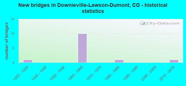
- New bridges - historical statistics
- 11930-1939
- 101960-1969
- 11980-1989
- 12010-2019


- Bridge Condition - Deck
- 10.0%Very good
- 40.0%Good
- 20.0%Satisfactory
- 30.0%Fair

- Bridge Condition - Superstructure
- 10.0%Very good
- 60.0%Good
- 10.0%Satisfactory
- 20.0%Fair

- Bridge Condition - Substructure
- 50.0%Good
- 20.0%Satisfactory
- 20.0%Fair
- 10.0%Poor

- Bridge Condition - Channel
- 28.6%Very good
- 42.9%Good
- 28.6%Satisfactory
Find on map >> Show street view
Structure Number: CLRSLR-0.02, Location: AT FRONTAGE ROAD (Lat: 39.765758, Lng: -105.626247), Route carried "on" structure: County highway , Year Built: 1980, Status: Open, Structure Length: 1.52m (4.99ft), Average Daily Traffic: 250 (year 2020), Truck Traffic: 4%, Average Future Daily Traffic: 312 (year 2040), Features Intersected: CLEAR CREEK, Facility Carried by Structure: SILVER LAKE DR
Minimum Vertical Clearance: 30+ m (98+ ft), Kilometerpoint: 0.082, Lanes on structure: 2, Owner: County Highway Agency, Approaching Roadway Width: 7.6m (24.9ft), Skew: 1 degrees, Material/Design: Steel, Design/Construction: Stringer/Multi-beam, Number Of Spans In Main Unit: 1, Length of Maximum Span: 14.3m (46.9ft), Curb-To-Curb Width: 6.9m (22.6ft), Out-to-Out Width: 7.1m (23.3ft)
Condition: Deck: Satisfactory, Superstructure: Satisfactory, Substructure: Fair, Channel: Good, Operating Rating: 30.8 metric tons, Method Used To Determine Operating Rating: Load Factor (LF), Inventory Rating: 18.4 metric tons, Method Used To Determine Inventory Rating: Load Factor (LF), Structural Evaluation: Somewhat better than minimum adequacy, Deck Geometry: Meets minimum limits, Waterway Adequacy: Equal to present desirable criteria, Approach Roadway Alignment: Somewhat better than minimum adequacy, Designated Inspection Frequency: Every 24 months, Inspection Date: April 2021, Deck Structure Type: Corrugated Steel, Wearing Surface/Protective System: Wearing Surface: Gravel
Find on map >> Show street view
Structure Number: CLRSLR-0.4, Location: WEST OF LAWSON (Lat: 39.763403, Lng: -105.633456), Route carried "on" structure: County highway , Year Built: 2010, Status: Open, Structure Length: 2.41m (7.91ft), Average Daily Traffic: 452 (year 2020), Truck Traffic: 4%, Average Future Daily Traffic: 565 (year 2040), Design Load: HL 93, Features Intersected: CLEAR CREEK, Facility Carried by Structure: ALVARADO RD
Minimum Vertical Clearance: 30+ m (98+ ft), Kilometerpoint: 6.323, Lanes on structure: 2, Owner: County Highway Agency, Approaching Roadway Width: 6.7m (22.0ft), Material/Design: Prestressed concrete, Design/Construction: Box Beam or Girders - Multiple, Number Of Spans In Main Unit: 1, Length of Maximum Span: 22.9m (75.1ft), Curb or Sidewalk Widths: Left: 1.5m (4.9ft), Right: 0.0m, Curb-To-Curb Width: 9.8m (32.2ft), Out-to-Out Width: 12.2m (40.0ft)
Condition: Deck: Very good, Superstructure: Very good, Substructure: Good, Channel: Very good, Operating Rating: 96.9 metric tons, Method Used To Determine Operating Rating: Load and Resistance Factor Rating (LRFR) rating reported by rating factor(RF) method using HL-93 loadings, Inventory Rating: 54.8 metric tons, Method Used To Determine Inventory Rating: Load and Resistance Factor Rating (LRFR) rating reported by rating factor(RF) method using HL-93 loadings, Structural Evaluation: Better than present minimum criteria, Deck Geometry: Equal to present minimum criteria, Waterway Adequacy: Equal to present desirable criteria, Approach Roadway Alignment: Equal to present desirable criteria, Designated Inspection Frequency: Every 24 months, Inspection Date: April 2021, Deck Structure Type: Concrete Cast-file-Place, Wearing Surface/Protective System: Wearing Surface: Bituminous, Membrane: Built-up, Deck Protection: Epoxy Coated Reinforcing
Find on map >> Show street view
Structure Number: E-14-AK, Location: 2.5 MI E OF JCT US 40 (Lat: 39.765392, Lng: -105.613989), Route carried "on" structure: Interstate 70A, Year Built: 1965, Status: Open, Structure Length: 3.63m (11.91ft), Average Daily Traffic: 18,500 (year 2020), Truck Traffic: 8%, Average Future Daily Traffic: 22,755 (year 2040), Design Load: HS 20, Features Intersected: COUNTY ROAD, Facility Carried by Structure: I 70 ML EBND
Minimum Vertical Clearance: 30+ m (98+ ft), Kilometerpoint: 378.539, Lanes on structure: 3, Lanes under structure: 2, Base Highway Network: Yes, Owner: State Highway Agency, Approaching Roadway Width: 11.6m (38.1ft), Skew: 10 degrees, Material/Design: Concrete continuous, Design/Construction: Tee Beam, Number Of Spans In Main Unit: 3, Length of Maximum Span: 14.3m (46.9ft), Curb-To-Curb Width: 11.6m (38.1ft), Out-to-Out Width: 12.8m (42.0ft)
Condition: Deck: Good, Superstructure: Good, Substructure: Good, Operating Rating: 49.2 metric tons, Method Used To Determine Operating Rating: Load Factor (LF), Inventory Rating: 29.4 metric tons, Method Used To Determine Inventory Rating: Load Factor (LF), Structural Evaluation: Better than present minimum criteria, Deck Geometry: High priority of replacement, Underclear: Somewhat better than minimum adequacy, Approach Roadway Alignment: Equal to present desirable criteria, Length Of Structure Improvement: 3.63m (11.91ft), Designated Inspection Frequency: Every 24 months, Inspection Date: August 2021, Bridge Improvement Cost: $360,000, Roadway Improvement Cost: $36,000, Total Project Cost: $396,000 ( Estimate for 2019), Deck Structure Type: Other, Wearing Surface/Protective System: Wearing Surface: Bituminous, Membrane: Preformed Fabric
Find on map >> Show street view
Structure Number: E-14-AL, Location: 1.7 MI E OF JCT US 40 (Lat: 39.766086, Lng: -105.627119), Route carried "on" structure: Interstate 70A, Year Built: 1965, Year Reconstructed: 1988, Status: Open, Structure Length: 4.87m (15.98ft), Average Daily Traffic: 37,000 (year 2020), Truck Traffic: 8%, Average Future Daily Traffic: 45,510 (year 2040), Design Load: HS 20+Mod, Features Intersected: RAMP TO I 70 ML, Facility Carried by Structure: I 70 ML
Minimum Vertical Clearance: 30+ m (98+ ft), Kilometerpoint: 377.401, Lanes on structure: 5, Lanes under structure: 2, Base Highway Network: Yes, Owner: State Highway Agency, Approaching Roadway Width: 23.2m (76.1ft), Skew: 34 degrees, Material/Design: Concrete continuous, Design/Construction: Tee Beam, Number Of Spans In Main Unit: 3, Length of Maximum Span: 19.2m (63.0ft), Curb-To-Curb Width: 23.2m (76.1ft), Out-to-Out Width: 24.6m (80.7ft)
Condition: Deck: Good, Superstructure: Good, Substructure: Satisfactory, Operating Rating: 57.7 metric tons, Method Used To Determine Operating Rating: Load Factor (LF), Inventory Rating: 34.6 metric tons, Method Used To Determine Inventory Rating: Load Factor (LF), Structural Evaluation: Equal to present minimum criteria, Deck Geometry: Somewhat better than minimum adequacy, Underclear: Meets minimum limits, Approach Roadway Alignment: Equal to present desirable criteria, Designated Inspection Frequency: Every 24 months, Inspection Date: August 2021, Deck Structure Type: Other, Wearing Surface/Protective System: Wearing Surface: Bituminous
Find on map >> Show street view
Structure Number: E-14-AM, Location: 1.1 MI E OF JCT US 40 (Lat: 39.763875, Lng: -105.635311), Route carried "on" structure: Interstate 70A, Year Built: 1965, Year Reconstructed: 1988, Status: Open, Structure Length: 4.87m (15.98ft), Average Daily Traffic: 37,000 (year 2020), Truck Traffic: 8%, Average Future Daily Traffic: 45,510 (year 2040), Design Load: HS 20+Mod, Features Intersected: COUNTY ROAD, Facility Carried by Structure: I 70 ML
Minimum Vertical Clearance: 30+ m (98+ ft), Kilometerpoint: 376.652, Lanes on structure: 5, Lanes under structure: 2, Base Highway Network: Yes, Owner: State Highway Agency, Approaching Roadway Width: 23.2m (76.1ft), Skew: 34 degrees, Material/Design: Concrete continuous, Design/Construction: Tee Beam, Number Of Spans In Main Unit: 3, Length of Maximum Span: 19.2m (63.0ft), Curb-To-Curb Width: 24.4m (80.1ft), Out-to-Out Width: 25.6m (84.0ft)
Condition: Deck: Good, Superstructure: Good, Substructure: Good, Operating Rating: 46.3 metric tons, Method Used To Determine Operating Rating: Load Factor (LF), Inventory Rating: 27.2 metric tons, Method Used To Determine Inventory Rating: Load Factor (LF), Structural Evaluation: Equal to present minimum criteria, Deck Geometry: Equal to present minimum criteria, Underclear: Meets minimum limits, Approach Roadway Alignment: Equal to present desirable criteria, Designated Inspection Frequency: Every 24 months, Inspection Date: August 2021, Deck Structure Type: Other, Wearing Surface/Protective System: Wearing Surface: Bituminous
Find on map >> Show street view
Structure Number: E-14-AV, Location: 0.4 MI NE OF JCT US 40 (Lat: 39.760908, Lng: -105.649203), Route carried "on" structure: Interstate 70A, Year Built: 1965, Status: Open, Structure Length: 0.88m (2.89ft), Average Daily Traffic: 37,000 (year 2020), Truck Traffic: 8%, Average Future Daily Traffic: 45,510 (year 2040), Design Load: HS 20, Features Intersected: CLEAR CREEK, Facility Carried by Structure: I 70 ML
Minimum Vertical Clearance: 30+ m (98+ ft), Kilometerpoint: 375.415, Lanes on structure: 7, Base Highway Network: Yes, Owner: State Highway Agency, Approaching Roadway Width: 29.9m (98.1ft), Skew: 33 degrees, Material/Design: Concrete, Design/Construction: Culvert, Number Of Spans In Main Unit: 2, Length of Maximum Span: 4.2m (13.8ft), Out-to-Out Width: 50.5m (165.7ft)
Condition: Channel: Satisfactory, Culverts: Poor, Operating Rating: 36.3 metric tons, Method Used To Determine Operating Rating: Field evaluation and documented engineering judgment, Inventory Rating: 32.7 metric tons, Method Used To Determine Inventory Rating: Field evaluation and documented engineering judgment, Structural Evaluation: Meets minimum limits, Waterway Adequacy: Equal to present desirable criteria, Approach Roadway Alignment: Equal to present desirable criteria, Length Of Structure Improvement: 1.55m (5.09ft), Designated Inspection Frequency: Every 24 months, Inspection Date: August 2021, Bridge Improvement Cost: $2,267,000, Roadway Improvement Cost: $227,000, Total Project Cost: $2,493,000 ( Estimate for 2019)
Find on map >> Show street view
Structure Number: E-14-AW, Location: 3.2 MI E OF JCT US 40 (Lat: 39.763317, Lng: -105.599233), Route carried "on" structure: ServiceInterstate 70A, Year Built: 1965, Status: Open, Structure Length: 3.05m (10.01ft), Average Daily Traffic: 36,000 (year 2020), Truck Traffic: 8%, Average Future Daily Traffic: 43,200 (year 2040), Design Load: HS 20, Features Intersected: CLEAR CREEK SR, Facility Carried by Structure: SERVICE ROAD
Minimum Vertical Clearance: 30+ m (98+ ft), Kilometerpoint: 0.069, Lanes on structure: 2, Base Highway Network: Yes, Owner: State Highway Agency, Approaching Roadway Width: 9.4m (30.8ft), Material/Design: Concrete continuous, Design/Construction: Tee Beam, Number Of Spans In Main Unit: 3, Length of Maximum Span: 11.6m (38.1ft), Curb or Sidewalk Widths: Left: 0.6m (2.0ft), Right: 0.6m (2.0ft), Curb-To-Curb Width: 8.5m (27.9ft), Out-to-Out Width: 9.8m (32.2ft)
Condition: Deck: Fair, Superstructure: Good, Substructure: Fair, Channel: Satisfactory, Operating Rating: 51.0 metric tons, Method Used To Determine Operating Rating: Load Factor (LF), Inventory Rating: 30.6 metric tons, Method Used To Determine Inventory Rating: Load Factor (LF), Structural Evaluation: Somewhat better than minimum adequacy, Deck Geometry: High priority of replacement, Waterway Adequacy: Equal to present desirable criteria, Approach Roadway Alignment: Equal to present minimum criteria, Designated Inspection Frequency: Every 24 months, Inspection Date: August 2021, Deck Structure Type: Other, Wearing Surface/Protective System: Wearing Surface: Bituminous, Membrane: Built-up
Find on map >> Show street view
Structure Number: E-14-AX, Location: 3.3 MI E OF JCT US 40 (Lat: 39.764311, Lng: -105.599133), Route carried "on" structure: County highway , Year Built: 1965, Status: Open, Structure Length: 5.79m (19.00ft), Average Daily Traffic: 1,066 (year 2021), Truck Traffic: 8%, Average Future Daily Traffic: 1,333 (year 2041), Design Load: HS 20, Features Intersected: I 70 ML, Facility Carried by Structure: COUNTY ROADS
Minimum Vertical Clearance: 30+ m (98+ ft), Kilometerpoint: 1.268, Lanes on structure: 2, Lanes under structure: 5, Owner: State Highway Agency, Approaching Roadway Width: 9.1m (29.9ft), Material/Design: Concrete continuous, Design/Construction: Tee Beam, Number Of Spans In Main Unit: 4, Length of Maximum Span: 16.0m (52.5ft), Curb or Sidewalk Widths: Left: 0.6m (2.0ft), Right: 0.6m (2.0ft), Curb-To-Curb Width: 8.5m (27.9ft), Out-to-Out Width: 9.8m (32.2ft)
Condition: Deck: Satisfactory, Superstructure: Good, Substructure: Good, Operating Rating: 59.6 metric tons, Method Used To Determine Operating Rating: Load Factor (LF), Inventory Rating: 35.7 metric tons, Method Used To Determine Inventory Rating: Load Factor (LF), Structural Evaluation: Better than present minimum criteria, Deck Geometry: Somewhat better than minimum adequacy, Underclear: Superior to present desirable criteria, Approach Roadway Alignment: Equal to present desirable criteria, Designated Inspection Frequency: Every 24 months, Inspection Date: August 2021, Deck Structure Type: Other, Wearing Surface/Protective System: Wearing Surface: Monolithic Concrete
Find on map >> Show street view
Structure Number: E-14-BA, Location: 3.7 MI EAST OF JCT US 40 (Lat: 39.761258, Lng: -105.577161), Route carried "on" structure: ServiceInterstate 70A, Year Built: 1965, Status: Open, Structure Length: 2.87m (9.42ft), Average Daily Traffic: 36,000 (year 2020), Truck Traffic: 8%, Average Future Daily Traffic: 42,480 (year 2040), Design Load: HS 20, Features Intersected: CLEAR CREEK AR, Facility Carried by Structure: N SPRING GULCH RD
Minimum Vertical Clearance: 30+ m (98+ ft), Kilometerpoint: 381.788, Lanes on structure: 1, Base Highway Network: Yes, Owner: State Highway Agency, Approaching Roadway Width: 6.7m (22.0ft), Material/Design: Concrete, Design/Construction: Tee Beam, Number Of Spans In Main Unit: 3, Length of Maximum Span: 9.4m (30.8ft), Curb or Sidewalk Widths: Left: 0.4m (1.3ft), Right: 0.4m (1.3ft), Curb-To-Curb Width: 4.9m (16.1ft), Out-to-Out Width: 5.8m (19.0ft)
Condition: Deck: Good, Superstructure: Good, Substructure: Good, Channel: Good, Operating Rating: 41.2 metric tons, Method Used To Determine Operating Rating: Load Factor (LF), Inventory Rating: 24.7 metric tons, Method Used To Determine Inventory Rating: Load Factor (LF), Structural Evaluation: Equal to present minimum criteria, Deck Geometry: High priority of replacement, Waterway Adequacy: Equal to present desirable criteria, Approach Roadway Alignment: Equal to present desirable criteria, Length Of Structure Improvement: 2.87m (9.42ft), Designated Inspection Frequency: Every 24 months, Inspection Date: August 2021, Bridge Improvement Cost: $88,000, Roadway Improvement Cost: $9,000, Total Project Cost: $97,000 ( Estimate for 2019), Deck Structure Type: Other, Wearing Surface/Protective System: Wearing Surface: Monolithic Concrete
Find on map >> Show street view
Structure Number: E-14-O, Location: 3.1 MI E OF JCT US 40 (Lat: 39.764831, Lng: -105.601722), Route carried "on" structure: ServiceInterstate 70A, Year Built: 1934, Status: Open, Structure Length: 0.98m (3.22ft), Average Daily Traffic: 36,000 (year 2020), Truck Traffic: 8%, Average Future Daily Traffic: 43,200 (year 2040), Features Intersected: MILL CREEK SR, Facility Carried by Structure: SERVICE ROAD
Minimum Vertical Clearance: 30+ m (98+ ft), Kilometerpoint: 1.041, Lanes on structure: 2, Base Highway Network: Yes, Owner: State Highway Agency, Approaching Roadway Width: 7.3m (24.0ft), Material/Design: Steel, Design/Construction: Stringer/Multi-beam, Number Of Spans In Main Unit: 1, Length of Maximum Span: 8.8m (28.9ft), Curb or Sidewalk Widths: Left: 1.5m (4.9ft), Right: 0.0m, Curb-To-Curb Width: 9.1m (29.9ft), Out-to-Out Width: 11.6m (38.1ft)
Condition: Deck: Fair, Superstructure: Fair, Substructure: Satisfactory, Channel: Good, Operating Rating: 41.3 metric tons, Method Used To Determine Operating Rating: Load Factor (LF), Inventory Rating: 24.8 metric tons, Method Used To Determine Inventory Rating: Load Factor (LF), Structural Evaluation: Somewhat better than minimum adequacy, Deck Geometry: High priority of corrective action, Waterway Adequacy: Equal to present desirable criteria, Approach Roadway Alignment: Equal to present desirable criteria, Designated Inspection Frequency: Every 24 months, Inspection Date: August 2021, Deck Structure Type: Concrete Cast-file-Place, Wearing Surface/Protective System: Wearing Surface: Bituminous
Find on map >> Show street view
Structure Number: E-14-S, Location: EMPIRE JNCTN. (Lat: 39.758817, Lng: -105.656075), Route carried "on" structure: US 40A, Year Built: 1965, Status: Open, Structure Length: 10.05m (32.97ft), Average Daily Traffic: 7,900 (year 2020), Truck Traffic: 5%, Average Future Daily Traffic: 8,611 (year 2040), Design Load: HS 20, Features Intersected: I 70 ML, CLEAR CREEK, Facility Carried by Structure: US 40 ML
Minimum Vertical Clearance: 30+ m (98+ ft), Kilometerpoint: 413.609, Lanes on structure: 2, Lanes under structure: 5, Base Highway Network: Yes, Owner: State Highway Agency, Approaching Roadway Width: 9.8m (32.2ft), Skew: 1 degrees, Material/Design: Steel, Design/Construction: Stringer/Multi-beam, Number Of Spans In Main Unit: 6, Length of Maximum Span: 18.3m (60.0ft), Curb-To-Curb Width: 9.1m (29.9ft), Out-to-Out Width: 10.4m (34.1ft)
Condition: Deck: Fair, Superstructure: Fair, Substructure: Poor, Channel: Very good, Operating Rating: 51.1 metric tons, Method Used To Determine Operating Rating: Load Factor (LF), Inventory Rating: 30.6 metric tons, Method Used To Determine Inventory Rating: Load Factor (LF), Structural Evaluation: Meets minimum limits, Deck Geometry: Meets minimum limits, Underclear: Somewhat better than minimum adequacy, Waterway Adequacy: Equal to present desirable criteria, Approach Roadway Alignment: Equal to present minimum criteria, Length Of Structure Improvement: 10.06m (33.01ft), Designated Inspection Frequency: Every 24 months, Inspection Date: April 2021, Bridge Improvement Cost: $1,212,000, Roadway Improvement Cost: $121,000, Total Project Cost: $1,818,000, Deck Structure Type: Concrete Cast-file-Place, Wearing Surface/Protective System: Wearing Surface: Bituminous, Membrane: Built-up
Find on map >> Show street view
Structure Number: E-14-AX, Location: 3.3 MI E OF JCT US 40 (Lat: 39.764311, Lng: -105.599133), Route carried "under" structure: Interstate 70A, Year Built: 1965, Structure Length: 0. m, Average Daily Traffic: 790 (year 2018), Truck Traffic: 11%, Features Intersected: I 70 ML, Facility Carried by Structure: COUNTY ROADS
Minimum Vertical Clearance: 6.38m (20.93ft), Kilometerpoint: 1.270, Lanes on structure: 2, Lanes under structure: 5, Material/Design: Concrete continuous, Design/Construction: Tee Beam, Length of Maximum Span: 16.0m (52.5ft)
Find on map >> Show street view
Structure Number: E-14-S, Location: EMPIRE JNCTN. (Lat: 39.758817, Lng: -105.656075), Route carried "under" structure: Interstate 70A, Year Built: 1965, Structure Length: 0. m, Average Daily Traffic: 37,000 (year 2011), Truck Traffic: 10%, Features Intersected: I 70 ML, CLEAR CREEK, Facility Carried by Structure: US 40 ML
Minimum Vertical Clearance: 5.94m (19.49ft), Kilometerpoint: 373.109, Lanes on structure: 2, Lanes under structure: 4, Material/Design: Steel, Design/Construction: Stringer/Multi-beam, Length of Maximum Span: 18.3m (60.0ft)