Bridge Statistics for Dowagiac, Michigan (MI)
Condition, Traffic, Stress, Structural Evaluation, Project Costs
- National Bridge Inventory (NBI) Statistics
- 19Number of bridges
- 102ft / 31.1mTotal length
- $690,000Total costs
- 38,802Total average daily traffic
- 1,638Total average daily truck traffic
- 190,140Total future (year 2015) average daily traffic
- National Bridge Inventory (NBI) Registered Bridges for Dowagiac
- No street view available for this location
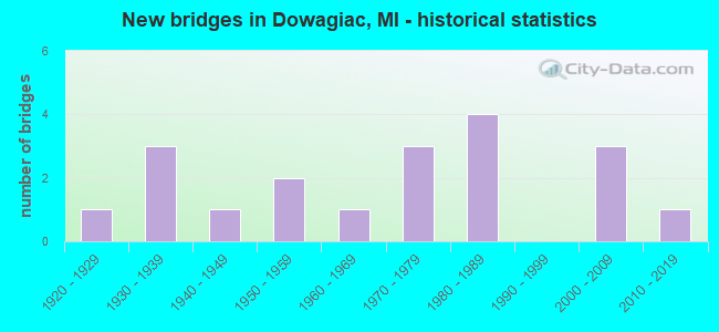
- New bridges - historical statistics
- 11920-1929
- 31930-1939
- 11940-1949
- 21950-1959
- 11960-1969
- 31970-1979
- 41980-1989
- 32000-2009
- 12010-2019

- Reconstructed bridges - Historical Statistics
- 11940-1949
- 01950-1959
- 01960-1969
- 01970-1979
- 01980-1989
- 11990-1999
- 12000-2009


- Bridge Condition - Deck
- 11.1%Very good
- 33.3%Good
- 22.2%Satisfactory
- 27.8%Fair
- 5.6%Poor

- Bridge Condition - Superstructure
- 5.6%Excellent
- 16.7%Very good
- 16.7%Good
- 22.2%Satisfactory
- 22.2%Fair
- 16.7%Poor

- Bridge Condition - Substructure
- 33.3%Very good
- 11.1%Good
- 38.9%Satisfactory
- 11.1%Poor
- 5.6%Serious

- Bridge Condition - Channel
- 11.1%Very good
- 11.1%Good
- 22.2%Satisfactory
- 50.0%Fair
- 5.6%Poor
Find on map >> Show street view
Structure Number: 249, Location: APPROX 1.0 MI W OF 2ND ST (Lat: 42.493956, Lng: -85.584225), Route carried "on" structure: County highway , Year Built: 1972, Status: Open, Structure Length: 2.04m (6.69ft), Average Daily Traffic: 125 (year 2002), Truck Traffic: 7%, Average Future Daily Traffic: 250 (year 2022), Design Load: HS 20+Mod, Features Intersected: GUN RIVER, Facility Carried by Structure: 110TH AVE
Minimum Vertical Clearance: 30+ m (98+ ft), Kilometerpoint: 8.794, Lanes on structure: 2, Owner: County Highway Agency, Approaching Roadway Width: 9.1m (29.9ft), Material/Design: Steel, Design/Construction: Stringer/Multi-beam, Number Of Spans In Main Unit: 1, Length of Maximum Span: 20.4m (66.9ft), Curb-To-Curb Width: 10.1m (33.1ft), Out-to-Out Width: 10.1m (33.1ft)
Condition: Deck: Fair, Superstructure: Good, Substructure: Very good, Channel: Satisfactory, Operating Rating: 84.2 metric tons, Method Used To Determine Operating Rating: Load Factor (LF) rating reported by rating factor (RF) method using MS18 loading, Inventory Rating: 50.5 metric tons, Method Used To Determine Inventory Rating: Load Factor (LF) rating reported by rating factor (RF) method using MS18 loading, Structural Evaluation: Better than present minimum criteria, Deck Geometry: Better than present minimum criteria, Waterway Adequacy: Equal to present desirable criteria, Approach Roadway Alignment: Equal to present desirable criteria, Designated Inspection Frequency: Every 24 months, Inspection Date: April 2021, Deck Structure Type: Concrete Cast-file-Place, Wearing Surface/Protective System: Wearing Surface: Integral Concrete
Find on map >> Show street view
Structure Number: 1421, Location: 0.3 MI W OF DOWAGIAC (Lat: 41.982750, Lng: -86.125686), Route carried "on" structure: State highway 51, Year Built: 1949, Year Reconstructed: 1998, Status: Open, Structure Length: 1.67m (5.48ft), Average Daily Traffic: 8,127 (year 2007), Truck Traffic: 5%, Average Future Daily Traffic: 17,890 (year 2018), Design Load: HS 20, Features Intersected: DOWAGIAC CREEK
Minimum Vertical Clearance: 30.48m (100.00ft), Kilometerpoint: 14.327, Lanes on structure: 3, Owner: State Highway Agency, Approaching Roadway Width: 12.5m (41.0ft), Skew: 4 degrees, Material/Design: Steel, Design/Construction: Stringer/Multi-beam, Number Of Spans In Main Unit: 1, Length of Maximum Span: 16.7m (54.8ft), Curb or Sidewalk Widths: Left: 1.2m (3.9ft), Right: 1.2m (3.9ft), Curb-To-Curb Width: 12.5m (41.0ft), Out-to-Out Width: 15.0m (49.2ft)
Condition: Deck: Satisfactory, Superstructure: Fair, Substructure: Satisfactory, Channel: Fair, Operating Rating: 96.5 metric tons, Method Used To Determine Operating Rating: Load Factor (LF), Inventory Rating: 57.8 metric tons, Method Used To Determine Inventory Rating: Load Factor (LF), Structural Evaluation: Somewhat better than minimum adequacy, Deck Geometry: Meets minimum limits, Waterway Adequacy: Equal to present desirable criteria, Approach Roadway Alignment: Equal to present desirable criteria, Designated Inspection Frequency: Every 24 months, Inspection Date: April 2021, Deck Structure Type: Concrete Cast-file-Place, Wearing Surface/Protective System: Wearing Surface: Monolithic Concrete, Deck Protection: Epoxy Coated Reinforcing
Find on map >> Show street view
Structure Number: 1422, Location: 3.0 MI S OF VAN BUREN COL (Lat: 42.027850, Lng: -86.107600), Route carried "on" structure: State highway 51, Year Built: 1952, Year Reconstructed: 2012, Status: Open, Structure Length: 1.68m (5.51ft), Average Daily Traffic: 6,146 (year 2012), Truck Traffic: 8%, Average Future Daily Traffic: 7,190 (year 2032), Design Load: HS 20, Features Intersected: DOWAGIAC RIVER
Minimum Vertical Clearance: 30.48m (100.00ft), Kilometerpoint: 5.855, Lanes on structure: 2, Base Highway Network: Yes (Inventory Route: 314, Subroute: 26), Owner: State Highway Agency, Approaching Roadway Width: 13.4m (44.0ft), Skew: 1 degrees, Material/Design: Steel, Design/Construction: Stringer/Multi-beam, Number Of Spans In Main Unit: 1, Length of Maximum Span: 16.0m (52.5ft), Curb-To-Curb Width: 11.6m (38.1ft), Out-to-Out Width: 13.2m (43.3ft)
Condition: Deck: Good, Superstructure: Satisfactory, Substructure: Satisfactory, Channel: Fair, Operating Rating: 97.2 metric tons, Method Used To Determine Operating Rating: Load Factor (LF) rating reported by rating factor (RF) method using MS18 loading, Inventory Rating: 64.8 metric tons, Method Used To Determine Inventory Rating: Load Factor (LF) rating reported by rating factor (RF) method using MS18 loading, Structural Evaluation: Equal to present minimum criteria, Deck Geometry: Somewhat better than minimum adequacy, Waterway Adequacy: Equal to present desirable criteria, Approach Roadway Alignment: Equal to present desirable criteria, Designated Inspection Frequency: Every 24 months, Inspection Date: April 2021, Deck Structure Type: Concrete Cast-file-Place, Wearing Surface/Protective System: Wearing Surface: Latex Concrete
Find on map >> Show street view
Structure Number: 143, Location: 1.9 MI W OF DOWAGIAC (Lat: 41.984011, Lng: -86.160064), Route carried "on" structure: State highway 62, Year Built: 1952, Status: Open, Structure Length: 1.22m (4.00ft), Average Daily Traffic: 5,743 (year 2012), Truck Traffic: 4%, Average Future Daily Traffic: 6,718 (year 2032), Design Load: HS 20, Features Intersected: DOWAGIAC CREEK
Minimum Vertical Clearance: 30.48m (100.00ft), Kilometerpoint: 3.051, Lanes on structure: 2, Base Highway Network: Yes (Inventory Route: 59, Subroute: 2), Owner: State Highway Agency, Approaching Roadway Width: 13.4m (44.0ft), Material/Design: Steel, Design/Construction: Stringer/Multi-beam, Number Of Spans In Main Unit: 1, Length of Maximum Span: 11.4m (37.4ft), Curb-To-Curb Width: 11.6m (38.1ft), Out-to-Out Width: 13.2m (43.3ft)
Condition: Deck: Good, Superstructure: Fair, Substructure: Satisfactory, Channel: Fair, Operating Rating: 56.4 metric tons, Method Used To Determine Operating Rating: Load Factor (LF) rating reported by rating factor (RF) method using MS18 loading, Inventory Rating: 33.7 metric tons, Method Used To Determine Inventory Rating: Load Factor (LF) rating reported by rating factor (RF) method using MS18 loading, Structural Evaluation: Somewhat better than minimum adequacy, Deck Geometry: Somewhat better than minimum adequacy, Waterway Adequacy: Equal to present desirable criteria, Approach Roadway Alignment: Equal to present desirable criteria, Designated Inspection Frequency: Every 24 months, Inspection Date: April 2021, Deck Structure Type: Concrete Cast-file-Place, Wearing Surface/Protective System: Wearing Surface: Monolithic Concrete
Find on map >> Show street view
Structure Number: 1454, Location: 4 MI W OF M-51 (Lat: 41.970831, Lng: -86.180089), Route carried "on" structure: County highway , Year Built: 1930, Status: Posted for load, Structure Length: 1.43m (4.69ft), Average Daily Traffic: 56 (year 2019), Average Future Daily Traffic: 70 (year 2039), Design Load: HS 20+Mod, Features Intersected: DOWAGIAC RIVER, Facility Carried by Structure: FROST STREET
Minimum Vertical Clearance: 30.48m (100.00ft), Kilometerpoint: 3.547, Lanes on structure: 2, Owner: County Highway Agency, Approaching Roadway Width: 7.3m (24.0ft), Skew: 3 degrees, Material/Design: Steel, Design/Construction: Stringer/Multi-beam, Number Of Spans In Main Unit: 1, Length of Maximum Span: 14.3m (46.9ft), Curb-To-Curb Width: 7.0m (23.0ft), Out-to-Out Width: 7.0m (23.0ft)
Condition: Deck: Poor, Superstructure: Poor, Substructure: Poor, Channel: Fair, Operating Rating: 20.1 metric tons, Method Used To Determine Operating Rating: Load Factor (LF) rating reported by rating factor (RF) method using MS18 loading, Inventory Rating: 12.0 metric tons, Method Used To Determine Inventory Rating: Load Factor (LF) rating reported by rating factor (RF) method using MS18 loading, Structural Evaluation: Meets minimum limits, Deck Geometry: Somewhat better than minimum adequacy, Waterway Adequacy: Equal to present minimum criteria, Approach Roadway Alignment: Equal to present desirable criteria, Bridge Posting: Required (Relationship of Operating Rating to Maximum Legal Load: > 39.9% below), Length Of Structure Improvement: 2.10m (6.89ft), Designated Inspection Frequency: Every 12 months, Inspection Date: October 2021, Bridge Improvement Cost: $210,000, Roadway Improvement Cost: $25,000, Total Project Cost: $235,000, Deck Structure Type: Concrete Cast-file-Place, Wearing Surface/Protective System: Wearing Surface: Bituminous, Membrane: Preformed Fabric
Find on map >> Show street view
Structure Number: 1456, Location: 5 MI N OF SUMNEVILLE (Lat: 41.945792, Lng: -86.189942), Route carried "on" structure: County highway , Year Built: 2019, Status: Open, Structure Length: 2.44m (8.01ft), Average Daily Traffic: 413 (year 2018), Average Future Daily Traffic: 631 (year 2038), Design Load: Greater than HL93, Features Intersected: DOWAGIAC RIVER, Facility Carried by Structure: SINK ROAD
Minimum Vertical Clearance: 30.48m (100.00ft), Kilometerpoint: 0.124, Lanes on structure: 2, Owner: County Highway Agency, Approaching Roadway Width: 7.9m (25.9ft), Skew: 2 degrees, Material/Design: Prestressed concrete, Design/Construction: Box Beam or Girders - Multiple, Number Of Spans In Main Unit: 1, Length of Maximum Span: 23.5m (77.1ft), Curb-To-Curb Width: 8.9m (29.2ft), Out-to-Out Width: 9.5m (31.2ft)
Condition: Deck: Very good, Superstructure: Excellent, Substructure: Very good, Channel: Very good, Operating Rating: 61.6 metric tons, Method Used To Determine Operating Rating: Load and Resistance Factor Rating (LRFR) rating reported by rating factor(RF) method using HL-93 loadings, Inventory Rating: 41.1 metric tons, Method Used To Determine Inventory Rating: Load and Resistance Factor Rating (LRFR) rating reported by rating factor(RF) method using HL-93 loadings, Structural Evaluation: Equal to present desirable criteria, Deck Geometry: Somewhat better than minimum adequacy, Waterway Adequacy: Equal to present desirable criteria, Approach Roadway Alignment: Meets minimum limits, Length Of Structure Improvement: 2.50m (8.20ft), Designated Inspection Frequency: Every 24 months, Inspection Date: October 2020, Bridge Improvement Cost: $225,000, Roadway Improvement Cost: $30,000, Total Project Cost: $255,000, Deck Structure Type: Concrete Cast-file-Place, Wearing Surface/Protective System: Wearing Surface: Monolithic Concrete, Deck Protection: Epoxy Coated Reinforcing
Find on map >> Show street view
Structure Number: 1457, Location: 3 MI W OF M-51 (Lat: 41.956308, Lng: -86.182183), Route carried "on" structure: County highway , Year Built: 1963, Status: Open, Structure Length: 1.98m (6.50ft), Average Daily Traffic: 917 (year 2013), Average Future Daily Traffic: 136,744 (year 2033), Design Load: HL 93, Features Intersected: DOWAGIAC RIVER, Facility Carried by Structure: PEAVINE STREET
Minimum Vertical Clearance: 30.48m (100.00ft), Kilometerpoint: 2.636, Lanes on structure: 2, Owner: County Highway Agency, Approaching Roadway Width: 7.9m (25.9ft), Material/Design: Prestressed concrete, Design/Construction: Box Beam or Girders - Multiple, Number Of Spans In Main Unit: 1, Length of Maximum Span: 19.8m (65.0ft), Curb-To-Curb Width: 7.9m (25.9ft), Out-to-Out Width: 9.1m (29.9ft)
Condition: Deck: Satisfactory, Superstructure: Satisfactory, Substructure: Satisfactory, Channel: Satisfactory, Operating Rating: 55.0 metric tons, Method Used To Determine Operating Rating: Load Factor (LF), Inventory Rating: 33.0 metric tons, Method Used To Determine Inventory Rating: Load Factor (LF), Structural Evaluation: Equal to present minimum criteria, Deck Geometry: Somewhat better than minimum adequacy, Waterway Adequacy: Better than present minimum criteria, Approach Roadway Alignment: Equal to present desirable criteria, Designated Inspection Frequency: Every 24 months, Inspection Date: October 2020, Deck Structure Type: Other, Wearing Surface/Protective System: Wearing Surface: Bituminous, Membrane: Built-up
Find on map >> Show street view
Structure Number: 1458, Location: 2.5 MI W OF DOWAGIAC (Lat: 41.987597, Lng: -86.155836), Route carried "on" structure: County highway , Year Built: 1984, Status: Open, Structure Length: 1.15m (3.77ft), Average Daily Traffic: 273 (year 2019), Average Future Daily Traffic: 300 (year 2039), Design Load: HS 20+Mod, Features Intersected: DOWAGIAC CREEK, Facility Carried by Structure: CALIFORNIA ROAD
Minimum Vertical Clearance: 30.48m (100.00ft), Kilometerpoint: 3.887, Lanes on structure: 2, Owner: County Highway Agency, Approaching Roadway Width: 8.8m (28.9ft), Material/Design: Prestressed concrete, Design/Construction: Box Beam or Girders - Multiple, Number Of Spans In Main Unit: 1, Length of Maximum Span: 11.5m (37.7ft), Curb-To-Curb Width: 7.6m (24.9ft), Out-to-Out Width: 7.6m (24.9ft)
Condition: Deck: Good, Superstructure: Very good, Substructure: Satisfactory, Channel: Fair, Operating Rating: 74.3 metric tons, Method Used To Determine Operating Rating: Load Factor (LF), Inventory Rating: 44.5 metric tons, Method Used To Determine Inventory Rating: Load Factor (LF), Structural Evaluation: Equal to present minimum criteria, Deck Geometry: Somewhat better than minimum adequacy, Waterway Adequacy: Equal to present desirable criteria, Approach Roadway Alignment: Equal to present desirable criteria, Designated Inspection Frequency: Every 24 months, Inspection Date: October 2020, Deck Structure Type: Concrete Cast-file-Place, Wearing Surface/Protective System: Wearing Surface: Bituminous, Membrane: Preformed Fabric, Deck Protection: Epoxy Coated Reinforcing
Find on map >> Show street view
Structure Number: 1459, Location: 1 MI N OF M-62 (Lat: 41.998461, Lng: -86.155706), Route carried "on" structure: County highway , Year Built: 1930, Status: Posted for load, Structure Length: 1.31m (4.30ft), Average Daily Traffic: 26 (year 2019), Average Future Daily Traffic: 30 (year 2039), Design Load: HS 20+Mod, Features Intersected: DOWAGIAC RIVER, Facility Carried by Structure: YAW STREET
Minimum Vertical Clearance: 30.48m (100.00ft), Kilometerpoint: 0.304, Lanes on structure: 2, Owner: County Highway Agency, Approaching Roadway Width: 8.8m (28.9ft), Material/Design: Steel, Design/Construction: Stringer/Multi-beam, Number Of Spans In Main Unit: 1, Length of Maximum Span: 13.1m (43.0ft), Curb-To-Curb Width: 5.2m (17.1ft), Out-to-Out Width: 5.7m (18.7ft)
Condition: Deck: Fair, Superstructure: Poor, Substructure: Poor, Channel: Poor, Operating Rating: 22.7 metric tons, Method Used To Determine Operating Rating: Load Factor (LF) rating reported by rating factor (RF) method using MS18 loading, Inventory Rating: 13.6 metric tons, Method Used To Determine Inventory Rating: Load Factor (LF) rating reported by rating factor (RF) method using MS18 loading, Structural Evaluation: Meets minimum limits, Deck Geometry: High priority of corrective action, Waterway Adequacy: Equal to present minimum criteria, Approach Roadway Alignment: Equal to present minimum criteria, Bridge Posting: Required (Relationship of Operating Rating to Maximum Legal Load: > 39.9% below), Designated Inspection Frequency: Every 24 months, Inspection Date: October 2020, Deck Structure Type: Concrete Cast-file-Place, Wearing Surface/Protective System: Wearing Surface: Bituminous
Find on map >> Show street view
Structure Number: 146, Location: 1 MI E OF M-51 (Lat: 42.038714, Lng: -86.088583), Route carried "on" structure: County highway , Year Built: 1930, Status: Posted for load, Structure Length: 1.40m (4.59ft), Average Daily Traffic: 70 (year 2019), Average Future Daily Traffic: 85 (year 2039), Design Load: HS 20+Mod, Features Intersected: DOWAGIAC RIVER, Facility Carried by Structure: RUDY ROAD
Minimum Vertical Clearance: 30.48m (100.00ft), Kilometerpoint: 6.558, Lanes on structure: 2, Owner: County Highway Agency, Approaching Roadway Width: 7.6m (24.9ft), Skew: 3 degrees, Material/Design: Steel, Design/Construction: Stringer/Multi-beam, Number Of Spans In Main Unit: 1, Length of Maximum Span: 14.0m (45.9ft), Curb-To-Curb Width: 5.2m (17.1ft), Out-to-Out Width: 6.1m (20.0ft)
Condition: Deck: Fair, Superstructure: Poor, Substructure: Serious, Channel: Fair, Operating Rating: 21.1 metric tons, Method Used To Determine Operating Rating: Load Factor (LF) rating reported by rating factor (RF) method using MS18 loading, Inventory Rating: 12.6 metric tons, Method Used To Determine Inventory Rating: Load Factor (LF) rating reported by rating factor (RF) method using MS18 loading, Structural Evaluation: High priority of corrective action, Deck Geometry: High priority of corrective action, Waterway Adequacy: Equal to present desirable criteria, Approach Roadway Alignment: Equal to present desirable criteria, Bridge Posting: Required (Relationship of Operating Rating to Maximum Legal Load: > 39.9% below), Length Of Structure Improvement: 2.00m (6.56ft), Designated Inspection Frequency: Every 12 months, Inspection Date: October 2021, Bridge Improvement Cost: $180,000, Roadway Improvement Cost: $20,000, Total Project Cost: $200,000, Deck Structure Type: Concrete Cast-file-Place, Wearing Surface/Protective System: Wearing Surface: Monolithic Concrete
Find on map >> Show street view
Structure Number: 1461, Location: 2.5 MI SW OF GLENWOOD (Lat: 42.049692, Lng: -86.069347), Route carried "on" structure: County highway , Year Built: 1974, Status: Open, Structure Length: 1.43m (4.69ft), Average Daily Traffic: 287 (year 2019), Average Future Daily Traffic: 350 (year 2039), Design Load: HS 20+Mod, Features Intersected: DOWAGIAC RIVER, Facility Carried by Structure: ATWOOD ROAD
Minimum Vertical Clearance: 30.48m (100.00ft), Kilometerpoint: 3.377, Lanes on structure: 2, Owner: County Highway Agency, Approaching Roadway Width: 8.5m (27.9ft), Material/Design: Prestressed concrete, Design/Construction: Box Beam or Girders - Multiple, Number Of Spans In Main Unit: 1, Length of Maximum Span: 14.3m (46.9ft), Curb-To-Curb Width: 7.3m (24.0ft), Out-to-Out Width: 7.5m (24.6ft)
Condition: Deck: Satisfactory, Superstructure: Satisfactory, Substructure: Satisfactory, Channel: Fair, Operating Rating: 51.5 metric tons, Method Used To Determine Operating Rating: Load Factor (LF) rating reported by rating factor (RF) method using MS18 loading, Inventory Rating: 30.8 metric tons, Method Used To Determine Inventory Rating: Load Factor (LF) rating reported by rating factor (RF) method using MS18 loading, Structural Evaluation: Equal to present minimum criteria, Deck Geometry: Somewhat better than minimum adequacy, Waterway Adequacy: Better than present minimum criteria, Approach Roadway Alignment: Better than present minimum criteria, Designated Inspection Frequency: Every 24 months, Inspection Date: October 2020, Deck Structure Type: Concrete Precast Panels, Wearing Surface/Protective System: Wearing Surface: Bituminous
Find on map >> Show street view
Structure Number: 1463, Location: 0.1 MI EAST OF S FRONT ST (Lat: 41.976764, Lng: -86.112725), Route carried "on" structure: City street 2042, Year Built: 1982, Status: Posted for load, Structure Length: 3.35m (10.99ft), Average Daily Traffic: 680 (year 1982), Average Future Daily Traffic: 680 (year 2015), Design Load: HS 20+Mod, Features Intersected: AMTRAK, Facility Carried by Structure: JEFFERSON AVE
Minimum Vertical Clearance: 30.48m (100.00ft), Kilometerpoint: 1.693, Lanes on structure: 2, Owner: City or Municipal Highway Agency, Approaching Roadway Width: 9.1m (29.9ft), Skew: 1 degrees, Material/Design: Prestressed concrete, Design/Construction: Box Beam or Girders - Multiple, Number Of Spans In Main Unit: 3, Length of Maximum Span: 11.5m (37.7ft), Curb or Sidewalk Widths: Left: 0.0m, Right: 1.9m (6.2ft), Curb-To-Curb Width: 9.1m (29.9ft), Out-to-Out Width: 11.4m (37.4ft)
Condition: Deck: Satisfactory, Superstructure: Good, Substructure: Satisfactory, Operating Rating: 43.7 metric tons, Method Used To Determine Operating Rating: Load Factor (LF) rating reported by rating factor (RF) method using MS18 loading, Inventory Rating: 26.2 metric tons, Method Used To Determine Inventory Rating: Load Factor (LF) rating reported by rating factor (RF) method using MS18 loading, Structural Evaluation: Equal to present minimum criteria, Deck Geometry: Equal to present minimum criteria, Underclear: High priority of corrective action, Approach Roadway Alignment: Equal to present minimum criteria, Bridge Posting: Required (Relationship of Operating Rating to Maximum Legal Load: 10.0 - 19.9% below), Designated Inspection Frequency: Every 24 months, Inspection Date: September 2021, Deck Structure Type: Other, Wearing Surface/Protective System: Wearing Surface: Bituminous, Membrane: Preformed Fabric
Find on map >> Show street view
Structure Number: 1464, Location: 0.1 MI N OF JEFFERSON AVE (Lat: 41.977639, Lng: -86.117047), Route carried "on" structure: City street 2042, Year Built: 2003, Status: Open, Structure Length: 1.68m (5.51ft), Average Daily Traffic: 709 (year 2022), Truck Traffic: 3%, Average Future Daily Traffic: 865 (year 2042), Design Load: HS 20, Features Intersected: DOWAGIAC CREEK, Facility Carried by Structure: LOWE STREET
Minimum Vertical Clearance: 30.48m (100.00ft), Kilometerpoint: 0.470, Lanes on structure: 2, Owner: City or Municipal Highway Agency, Approaching Roadway Width: 8.5m (27.9ft), Skew: 1 degrees, Material/Design: Prestressed concrete, Design/Construction: Box Beam or Girders - Multiple, Number Of Spans In Main Unit: 1, Length of Maximum Span: 15.5m (50.9ft), Curb or Sidewalk Widths: Left: 0.0m, Right: 2.0m (6.6ft), Curb-To-Curb Width: 8.8m (28.9ft), Out-to-Out Width: 11.4m (37.4ft)
Condition: Deck: Good, Superstructure: Very good, Substructure: Very good, Channel: Satisfactory, Operating Rating: 66.9 metric tons, Method Used To Determine Operating Rating: Load Factor (LF), Inventory Rating: 40.1 metric tons, Method Used To Determine Inventory Rating: Load Factor (LF), Structural Evaluation: Equal to present desirable criteria, Deck Geometry: Somewhat better than minimum adequacy, Waterway Adequacy: Better than present minimum criteria, Approach Roadway Alignment: Equal to present desirable criteria, Designated Inspection Frequency: Every 24 months, Inspection Date: September 2021, Deck Structure Type: Concrete Cast-file-Place, Wearing Surface/Protective System: Wearing Surface: Integral Concrete, Deck Protection: Epoxy Coated Reinforcing
Find on map >> Show street view
Structure Number: 1465, Location: 0.1 MI S OF HIGH STREET (Lat: 41.979081, Lng: -86.112128), Route carried "on" structure: City street 2042, Year Built: 1924, Year Reconstructed: 1952, Status: Open, Structure Length: 1.40m (4.59ft), Average Daily Traffic: 4,034 (year 2022), Average Future Daily Traffic: 4,922 (year 2042), Design Load: HS 20+Mod, Features Intersected: DOWAGIAC CREEK, Facility Carried by Structure: SOUTH FRONT STREET
Minimum Vertical Clearance: 30.48m (100.00ft), Kilometerpoint: 0.309, Lanes on structure: 2, Owner: City or Municipal Highway Agency, Approaching Roadway Width: 11.0m (36.1ft), Skew: 3 degrees, Material/Design: Concrete, Design/Construction: Slab, Number Of Spans In Main Unit: 2, Length of Maximum Span: 6.7m (22.0ft), Curb or Sidewalk Widths: Left: 1.2m (3.9ft), Right: 0.4m (1.3ft), Curb-To-Curb Width: 9.1m (29.9ft), Out-to-Out Width: 11.8m (38.7ft)
Condition: Deck: Fair, Superstructure: Fair, Substructure: Very good, Channel: Good, Operating Rating: 42.6 metric tons, Method Used To Determine Operating Rating: Load Factor (LF), Inventory Rating: 25.5 metric tons, Method Used To Determine Inventory Rating: Load Factor (LF), Structural Evaluation: Somewhat better than minimum adequacy, Deck Geometry: Meets minimum limits, Waterway Adequacy: Equal to present desirable criteria, Approach Roadway Alignment: Equal to present desirable criteria, Designated Inspection Frequency: Every 24 months, Inspection Date: September 2021, Deck Structure Type: Concrete Cast-file-Place, Wearing Surface/Protective System: Wearing Surface: Monolithic Concrete
Find on map >> Show street view
Structure Number: 1466, Location: 0.1 MI N OF JEFFERSON AVE (Lat: 41.977850, Lng: -86.107269), Route carried "on" structure: City street 2042, Year Built: 1970, Status: Posted for load, Structure Length: 1.06m (3.48ft), Average Daily Traffic: 2,430 (year 2022), Average Future Daily Traffic: 2,965 (year 2042), Design Load: HS 20+Mod, Features Intersected: DOWAGIAC CREEK, Facility Carried by Structure: CASS AVENUE
Minimum Vertical Clearance: 30.48m (100.00ft), Kilometerpoint: 7.292, Lanes on structure: 2, Owner: City or Municipal Highway Agency, Approaching Roadway Width: 9.1m (29.9ft), Material/Design: Prestressed concrete, Design/Construction: Box Beam or Girders - Multiple, Number Of Spans In Main Unit: 1, Length of Maximum Span: 10.0m (32.8ft), Curb or Sidewalk Widths: Left: 1.5m (4.9ft), Right: 0.0m, Curb-To-Curb Width: 9.1m (29.9ft), Out-to-Out Width: 11.4m (37.4ft)
Condition: Deck: Fair, Superstructure: Fair, Substructure: Good, Channel: Good, Operating Rating: 56.9 metric tons, Method Used To Determine Operating Rating: Load Factor (LF), Inventory Rating: 34.1 metric tons, Method Used To Determine Inventory Rating: Load Factor (LF), Structural Evaluation: Somewhat better than minimum adequacy, Deck Geometry: Meets minimum limits, Waterway Adequacy: Better than present minimum criteria, Approach Roadway Alignment: Better than present minimum criteria, Bridge Posting: Required (Relationship of Operating Rating to Maximum Legal Load: 0.1 - 9.9% below), Designated Inspection Frequency: Every 24 months, Inspection Date: September 2021, Deck Structure Type: Other, Wearing Surface/Protective System: Wearing Surface: Bituminous, Membrane: Preformed Fabric
Find on map >> Show street view
Structure Number: 1467, Location: 0.2 MI SOUTH OF HIGH ST (Lat: 41.978408, Lng: -86.109325), Route carried "on" structure: City street , Year Built: 1980, Status: Posted for load, Structure Length: 1.64m (5.38ft), Average Daily Traffic: 639 (year 2022), Average Future Daily Traffic: 780 (year 2042), Design Load: HS 20+Mod, Features Intersected: DOWAGIAC CREEK, Facility Carried by Structure: HENRY STREET
Minimum Vertical Clearance: 30.48m (100.00ft), Kilometerpoint: 0.496, Lanes on structure: 2, Owner: City or Municipal Highway Agency, Approaching Roadway Width: 6.1m (20.0ft), Material/Design: Prestressed concrete, Design/Construction: Box Beam or Girders - Multiple, Number Of Spans In Main Unit: 1, Length of Maximum Span: 16.4m (53.8ft), Curb or Sidewalk Widths: Left: 0.0m, Right: 1.5m (4.9ft), Curb-To-Curb Width: 7.9m (25.9ft), Out-to-Out Width: 10.2m (33.5ft)
Condition: Deck: Good, Superstructure: Satisfactory, Substructure: Good, Channel: Satisfactory, Operating Rating: 32.4 metric tons, Method Used To Determine Operating Rating: Load Factor (LF) rating reported by rating factor (RF) method using MS18 loading, Inventory Rating: 19.4 metric tons, Method Used To Determine Inventory Rating: Load Factor (LF) rating reported by rating factor (RF) method using MS18 loading, Structural Evaluation: Somewhat better than minimum adequacy, Deck Geometry: Somewhat better than minimum adequacy, Waterway Adequacy: Better than present minimum criteria, Approach Roadway Alignment: Better than present minimum criteria, Bridge Posting: Required (Relationship of Operating Rating to Maximum Legal Load: 30.0 - 39.9% below), Designated Inspection Frequency: Every 24 months, Inspection Date: September 2021, Deck Structure Type: Other, Wearing Surface/Protective System: Wearing Surface: Bituminous, Membrane: Preformed Fabric
Find on map >> Show street view
Structure Number: 1468, Location: 0.2 MI SOUTH OF DIVISION (Lat: 41.981869, Lng: -86.097294), Route carried "on" structure: City street 14040, Year Built: 1984, Status: Posted for load, Structure Length: 2.59m (8.50ft), Average Daily Traffic: 2,065 (year 2022), Average Future Daily Traffic: 2,520 (year 2042), Design Load: HS 20+Mod, Features Intersected: DOWAGIAC CREEK, Facility Carried by Structure: RIVERSIDE DRIVE
Minimum Vertical Clearance: 30.48m (100.00ft), Kilometerpoint: 0.529, Lanes on structure: 2, Owner: City or Municipal Highway Agency, Approaching Roadway Width: 9.1m (29.9ft), Material/Design: Prestressed concrete, Design/Construction: Box Beam or Girders - Multiple, Number Of Spans In Main Unit: 1, Length of Maximum Span: 25.9m (85.0ft), Curb or Sidewalk Widths: Left: 1.6m (5.2ft), Right: 1.6m (5.2ft), Curb-To-Curb Width: 9.1m (29.9ft), Out-to-Out Width: 12.6m (41.3ft)
Condition: Deck: Very good, Superstructure: Good, Substructure: Very good, Channel: Fair, Operating Rating: 30.8 metric tons, Method Used To Determine Operating Rating: Load Factor (LF) rating reported by rating factor (RF) method using MS18 loading, Inventory Rating: 18.5 metric tons, Method Used To Determine Inventory Rating: Load Factor (LF) rating reported by rating factor (RF) method using MS18 loading, Structural Evaluation: Somewhat better than minimum adequacy, Deck Geometry: Meets minimum limits, Waterway Adequacy: Superior to present desirable criteria, Approach Roadway Alignment: Equal to present desirable criteria, Bridge Posting: Required (Relationship of Operating Rating to Maximum Legal Load: > 39.9% below), Designated Inspection Frequency: Every 24 months, Inspection Date: September 2021, Deck Structure Type: Other, Wearing Surface/Protective System: Wearing Surface: Bituminous, Membrane: Preformed Fabric
Find on map >> Show street view
Structure Number: F523, Location: EDWARDS STREET (Lat: 41.948419, Lng: -86.187842), Route carried "on" structure: Federal lands road 1214, Year Built: 2008, Status: Open, Structure Length: 0.94m (3.08ft), Average Daily Traffic: 25 (year 2021), Truck Traffic: 5%, Average Future Daily Traffic: 50 (year 2041), Design Load: HS 20, Features Intersected: PEAVINE CREEK
Minimum Vertical Clearance: 30+ m (98+ ft), Kilometerpoint: 0.100, Lanes on structure: 2, Owner: Bureau of Indian Affairs, Approaching Roadway Width: 5.5m (18.0ft), Material/Design: Prestressed concrete, Design/Construction: Box Beam or Girders - Multiple, Number Of Spans In Main Unit: 1, Length of Maximum Span: 9.4m (30.8ft), Curb or Sidewalk Widths: Left: 0.5m (1.6ft), Right: 0.5m (1.6ft), Curb-To-Curb Width: 7.6m (24.9ft), Out-to-Out Width: 8.6m (28.2ft)
Condition: Deck: Good, Superstructure: Very good, Substructure: Very good, Channel: Very good, Operating Rating: 79.0 metric tons, Method Used To Determine Operating Rating: Load Factor (LF), Inventory Rating: 53.9 metric tons, Method Used To Determine Inventory Rating: Load Factor (LF), Structural Evaluation: Equal to present desirable criteria, Waterway Adequacy: Better than present minimum criteria, Approach Roadway Alignment: Equal to present desirable criteria, Designated Inspection Frequency: Every 24 months, Inspection Date: September 2021, Deck Structure Type: Concrete Cast-file-Place, Wearing Surface/Protective System: Deck Protection: Epoxy Coated Reinforcing
Find on map >> Show street view
Structure Number: 13491, Location: 4 MI S OF DOWAGIAC (Lat: 41.938483, Lng: -86.165183), Route carried "on" structure: State highway 51, Year Built: 2009, Status: Open, Structure Length: 0.66m (2.17ft), Average Daily Traffic: 6,037 (year 2007), Truck Traffic: 8%, Average Future Daily Traffic: 7,100 (year 2029), Design Load: Greater than HL93, Features Intersected: PEAVINE CREEK
Minimum Vertical Clearance: 30.48m (100.00ft), Kilometerpoint: 8.398, Lanes on structure: 2, Base Highway Network: Yes (Inventory Route: 59, Subroute: 9), Owner: State Highway Agency, Approaching Roadway Width: 9.1m (29.9ft), Material/Design: Concrete, Design/Construction: Culvert, Number Of Spans In Main Unit: 1, Length of Maximum Span: 6.1m (20.0ft), Curb-To-Curb Width: 13.4m (44.0ft), Out-to-Out Width: 14.9m (48.9ft)
Condition: Channel: Fair, Culverts: Good, Operating Rating: 87.2 metric tons, Method Used To Determine Operating Rating: Load and Resistance Factor Rating (LRFR) rating reported by rating factor(RF) method using HL-93 loadings, Inventory Rating: 32.4 metric tons, Method Used To Determine Inventory Rating: Load and Resistance Factor Rating (LRFR) rating reported by rating factor(RF) method using HL-93 loadings, Structural Evaluation: Better than present minimum criteria, Deck Geometry: Equal to present minimum criteria, Waterway Adequacy: Better than present minimum criteria, Approach Roadway Alignment: Equal to present desirable criteria, Designated Inspection Frequency: Every 24 months, Inspection Date: March 2021, Wearing Surface/Protective System: Wearing Surface: Bituminous