Bridge Statistics for Donnelsville, Ohio (OH)
Condition, Traffic, Stress, Structural Evaluation, Project Costs
- National Bridge Inventory (NBI) Statistics
- 17Number of bridges
- 108ft / 33.1mTotal length
- $400,000,000Total costs
- 48,048Total average daily traffic
- 3,032Total average daily truck traffic
- National Bridge Inventory (NBI) Registered Bridges for Donnelsville
- No street view available for this location
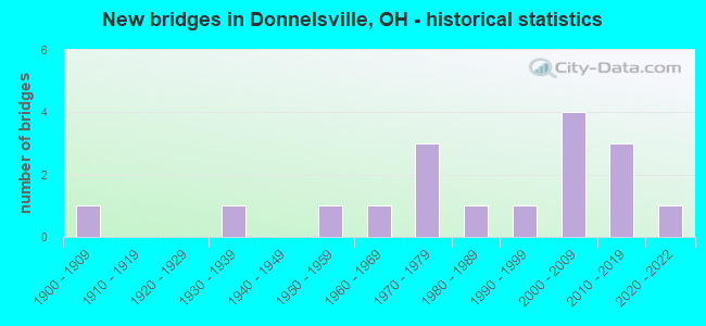
- New bridges - historical statistics
- 11900-1909
- 11930-1939
- 11950-1959
- 11960-1969
- 31970-1979
- 11980-1989
- 11990-1999
- 42000-2009
- 32010-2019
- 12020-2022

- Reconstructed bridges - Historical Statistics
- 11960-1969
- 01970-1979
- 11980-1989
- 01990-1999
- 12000-2009
- 12010-2019


- Bridge Condition - Deck
- 40.0%Excellent
- 20.0%Very good
- 13.3%Good
- 20.0%Satisfactory
- 6.7%Fair

- Bridge Condition - Superstructure
- 53.3%Excellent
- 6.7%Very good
- 20.0%Good
- 13.3%Satisfactory
- 6.7%Fair

- Bridge Condition - Substructure
- 26.7%Excellent
- 26.7%Very good
- 26.7%Good
- 20.0%Satisfactory

- Bridge Condition - Channel
- 30.8%Excellent
- 23.1%Very good
- 46.2%Satisfactory
Find on map >> Show street view
Structure Number: 1200194, Location: JCT. SR-369 (Lat: 39.907550, Lng: -83.909311), Route carried "on" structure: State highway 4, Year Built: 2005, Status: Open, Structure Length: 3.49m (11.45ft), Average Daily Traffic: 10,216 (year 2015), Truck Traffic: 8%, Average Future Daily Traffic: 14,180 (year 2035), Design Load: HS 25 or greater, Features Intersected: SR-369
Minimum Vertical Clearance: 30+ m (98+ ft), Kilometerpoint: 13.824, Lanes on structure: 3, Lanes under structure: 2, Base Highway Network: Yes (, Subroute: 1), Owner: State Highway Agency, Approaching Roadway Width: 11.0m (36.1ft), Skew: 4 degrees, Material/Design: Steel, Design/Construction: Stringer/Multi-beam, Number Of Spans In Main Unit: 1, Length of Maximum Span: 33.8m (110.9ft), Curb-To-Curb Width: 16.5m (54.1ft), Out-to-Out Width: 17.4m (57.1ft)
Condition: Deck: Very good, Superstructure: Excellent, Substructure: Very good, Operating Rating: 42.1 metric tons, Method Used To Determine Operating Rating: Allowable Stress (AS) rating reported by rating factor (RF) method using MS18 loading, Inventory Rating: 32.4 metric tons, Method Used To Determine Inventory Rating: Allowable Stress (AS) rating reported by rating factor (RF) method using MS18 loading, Structural Evaluation: Equal to present desirable criteria, Deck Geometry: Better than present minimum criteria, Underclear: High priority of corrective action, Approach Roadway Alignment: Equal to present desirable criteria, Designated Inspection Frequency: Every 24 months, Inspection Date: August 2021, Deck Structure Type: Concrete Cast-file-Place, Wearing Surface/Protective System: Wearing Surface: Monolithic Concrete, Deck Protection: Epoxy Coated Reinforcing
Find on map >> Show street view
Structure Number: 1200224, Location: JCT. SR-369 (Lat: 39.907469, Lng: -83.908811), Route carried "on" structure: State highway 4, Year Built: 2004, Status: Open, Structure Length: 3.49m (11.45ft), Average Daily Traffic: 10,216 (year 2015), Truck Traffic: 8%, Average Future Daily Traffic: 14,180 (year 2035), Design Load: HS 25 or greater, Features Intersected: SR-369
Minimum Vertical Clearance: 30+ m (98+ ft), Kilometerpoint: 13.824, Lanes on structure: 2, Lanes under structure: 2, Base Highway Network: Yes (, Subroute: 1), Owner: State Highway Agency, Approaching Roadway Width: 11.0m (36.1ft), Skew: 4 degrees, Material/Design: Steel, Design/Construction: Stringer/Multi-beam, Number Of Spans In Main Unit: 1, Length of Maximum Span: 33.8m (110.9ft), Curb-To-Curb Width: 16.5m (54.1ft), Out-to-Out Width: 17.4m (57.1ft)
Condition: Deck: Very good, Superstructure: Excellent, Substructure: Very good, Operating Rating: 42.1 metric tons, Method Used To Determine Operating Rating: Load Factor (LF) rating reported by rating factor (RF) method using MS18 loading, Inventory Rating: 32.4 metric tons, Method Used To Determine Inventory Rating: Load Factor (LF) rating reported by rating factor (RF) method using MS18 loading, Structural Evaluation: Equal to present desirable criteria, Deck Geometry: Superior to present desirable criteria, Underclear: High priority of corrective action, Approach Roadway Alignment: Equal to present desirable criteria, Designated Inspection Frequency: Every 24 months, Inspection Date: August 2021, Deck Structure Type: Concrete Cast-file-Place, Wearing Surface/Protective System: Wearing Surface: Monolithic Concrete, Deck Protection: Epoxy Coated Reinforcing
Find on map >> Show street view
Structure Number: 1200763, Location: 1.65 MI E OF JCT SR571 (Lat: 39.914331, Lng: -83.978861), Route carried "on" structure: US 40, Year Built: 1983, Status: Open, Structure Length: 1.62m (5.31ft), Average Daily Traffic: 3,847 (year 2015), Truck Traffic: 3%, Average Future Daily Traffic: 5,340 (year 2035), Design Load: HS 20+Mod, Features Intersected: JACKSON CREEK
Minimum Vertical Clearance: 30+ m (98+ ft), Kilometerpoint: 6.003, Lanes on structure: 2, Owner: State Highway Agency, Approaching Roadway Width: 12.2m (40.0ft), Skew: 2 degrees, Material/Design: Prestressed concrete, Design/Construction: Box Beam or Girders - Multiple, Number Of Spans In Main Unit: 1, Length of Maximum Span: 15.2m (49.9ft), Curb-To-Curb Width: 12.2m (40.0ft), Out-to-Out Width: 12.2m (40.0ft)
Condition: Deck: Fair, Superstructure: Fair, Substructure: Good, Channel: Very good, Operating Rating: 42.1 metric tons, Method Used To Determine Operating Rating: Load Factor (LF) rating reported by rating factor (RF) method using MS18 loading, Inventory Rating: 32.4 metric tons, Method Used To Determine Inventory Rating: Load Factor (LF) rating reported by rating factor (RF) method using MS18 loading, Structural Evaluation: Somewhat better than minimum adequacy, Deck Geometry: Equal to present minimum criteria, Waterway Adequacy: Equal to present desirable criteria, Approach Roadway Alignment: Equal to present desirable criteria, Designated Inspection Frequency: Every 12 months, Inspection Date: September 2021, Deck Structure Type: Concrete Cast-file-Place
Find on map >> Show street view
Structure Number: 1200844, Location: 1.96MI.W. OF JCT. SR-369 (Lat: 39.917361, Lng: -83.949661), Route carried "on" structure: US 40, Year Built: 1931, Year Reconstructed: 1992, Status: Open, Structure Length: 2.01m (6.59ft), Average Daily Traffic: 3,847 (year 2015), Truck Traffic: 3%, Average Future Daily Traffic: 5,340 (year 2035), Design Load: HS 20+Mod, Features Intersected: DONNELS CREEK
Minimum Vertical Clearance: 30+ m (98+ ft), Kilometerpoint: 8.530, Lanes on structure: 2, Owner: State Highway Agency, Approaching Roadway Width: 12.2m (40.0ft), Material/Design: Prestressed concrete, Design/Construction: Box Beam or Girders - Multiple, Number Of Spans In Main Unit: 1, Length of Maximum Span: 19.5m (64.0ft), Curb-To-Curb Width: 13.4m (44.0ft), Out-to-Out Width: 13.4m (44.0ft)
Condition: Deck: Good, Superstructure: Good, Substructure: Good, Channel: Satisfactory, Operating Rating: 51.8 metric tons, Method Used To Determine Operating Rating: Load and Resistance Factor Rating (LRFR) rating reported by rating factor(RF) method using HL-93 loadings, Inventory Rating: 32.4 metric tons, Method Used To Determine Inventory Rating: Load and Resistance Factor Rating (LRFR) rating reported by rating factor(RF) method using HL-93 loadings, Structural Evaluation: Better than present minimum criteria, Deck Geometry: Better than present minimum criteria, Waterway Adequacy: Equal to present minimum criteria, Approach Roadway Alignment: Better than present minimum criteria, Designated Inspection Frequency: Every 24 months, Inspection Date: September 2021, Deck Structure Type: Concrete Cast-file-Place, Wearing Surface/Protective System: Wearing Surface: Bituminous
Find on map >> Show street view
Structure Number: 1230003, Location: 1/4 MI W SNIDER RD (Lat: 39.898331, Lng: -83.972781), Route carried "on" structure: County highway C0316, Year Built: 2015, Status: Open, Structure Length: 1.10m (3.61ft), Average Daily Traffic: 2,580 (year 2015), Truck Traffic: 4%, Average Future Daily Traffic: 2,580 (year 2035), Design Load: HL 93, Features Intersected: LOWER VALLEY & JACKSON C, Facility Carried by Structure: C-316
Minimum Vertical Clearance: 30+ m (98+ ft), Kilometerpoint: 8.723, Lanes on structure: 2, Owner: County Highway Agency, Approaching Roadway Width: 9.8m (32.2ft), Material/Design: Prestressed concrete, Design/Construction: Box Beam or Girders - Multiple, Number Of Spans In Main Unit: 1, Length of Maximum Span: 10.7m (35.1ft), Curb-To-Curb Width: 9.8m (32.2ft), Out-to-Out Width: 9.8m (32.2ft)
Condition: Deck: Excellent, Superstructure: Excellent, Substructure: Excellent, Channel: Excellent, Operating Rating: 71.3 metric tons, Method Used To Determine Operating Rating: Load and Resistance Factor Rating (LRFR) rating reported by rating factor(RF) method using HL-93 loadings, Inventory Rating: 55.1 metric tons, Method Used To Determine Inventory Rating: Load and Resistance Factor Rating (LRFR) rating reported by rating factor(RF) method using HL-93 loadings, Structural Evaluation: Superior to present desirable criteria, Deck Geometry: Meets minimum limits, Waterway Adequacy: Superior to present desirable criteria, Approach Roadway Alignment: Superior to present desirable criteria, Designated Inspection Frequency: Every 24 months, Inspection Date: October 2021, Total Project Cost: $400,000,000, Deck Structure Type: Concrete Cast-file-Place, Wearing Surface/Protective System: Wearing Surface: Monolithic Concrete, Membrane: Epoxy, Deck Protection: Epoxy Coated Reinforcing
Find on map >> Show street view
Structure Number: 1230004, Location: 1/4 MI E OF N. HAMPTON RD (Lat: 39.902200, Lng: -83.951100), Route carried "on" structure: County highway C0316, Year Built: 2015, Status: Open, Structure Length: 2.36m (7.74ft), Average Daily Traffic: 1,790 (year 2016), Truck Traffic: 4%, Average Future Daily Traffic: 1,790 (year 2036), Design Load: HL 93, Features Intersected: LOWER VALLEY & DONNELS C, Facility Carried by Structure: C-316
Minimum Vertical Clearance: 30+ m (98+ ft), Kilometerpoint: 10.638, Lanes on structure: 2, Owner: County Highway Agency, Approaching Roadway Width: 9.8m (32.2ft), Skew: 1 degrees, Material/Design: Prestressed concrete, Design/Construction: Box Beam or Girders - Multiple, Number Of Spans In Main Unit: 1, Length of Maximum Span: 23.2m (76.1ft), Curb-To-Curb Width: 9.8m (32.2ft), Out-to-Out Width: 9.8m (32.2ft)
Condition: Deck: Excellent, Superstructure: Excellent, Substructure: Excellent, Channel: Excellent, Operating Rating: 71.3 metric tons, Method Used To Determine Operating Rating: Load and Resistance Factor Rating (LRFR) rating reported by rating factor(RF) method using HL-93 loadings, Inventory Rating: 55.1 metric tons, Method Used To Determine Inventory Rating: Load and Resistance Factor Rating (LRFR) rating reported by rating factor(RF) method using HL-93 loadings, Structural Evaluation: Superior to present desirable criteria, Deck Geometry: Somewhat better than minimum adequacy, Waterway Adequacy: Superior to present desirable criteria, Approach Roadway Alignment: Superior to present desirable criteria, Length Of Structure Improvement: 2.32m (7.61ft), Designated Inspection Frequency: Every 24 months, Inspection Date: October 2021, Deck Structure Type: Concrete Cast-file-Place, Wearing Surface/Protective System: Wearing Surface: Monolithic Concrete, Membrane: Epoxy, Deck Protection: Epoxy Coated Reinforcing
Find on map >> Show street view
Structure Number: 1231367, Location: 1/4 MILE NO OF MYERS RD (Lat: 39.950150, Lng: -83.929361), Route carried "on" structure: County highway T0310, Year Built: 1976, Status: Open, Structure Length: 1.10m (3.61ft), Average Daily Traffic: 1,197 (year 2015), Truck Traffic: 8%, Average Future Daily Traffic: 1,661 (year 2035), Design Load: HS 20, Features Intersected: FOLK REAM O DONNELS CR, Facility Carried by Structure: COUNTY RD NO 310
Minimum Vertical Clearance: 30+ m (98+ ft), Kilometerpoint: 1.239, Lanes on structure: 2, Owner: County Highway Agency, Approaching Roadway Width: 7.0m (23.0ft), Skew: 2 degrees, Material/Design: Prestressed concrete, Design/Construction: Box Beam or Girders - Multiple, Number Of Spans In Main Unit: 1, Length of Maximum Span: 11.0m (36.1ft), Curb-To-Curb Width: 7.3m (24.0ft), Out-to-Out Width: 7.3m (24.0ft)
Condition: Deck: Good, Superstructure: Good, Substructure: Satisfactory, Channel: Satisfactory, Operating Rating: 68.0 metric tons, Method Used To Determine Operating Rating: Load Factor (LF) rating reported by rating factor (RF) method using MS18 loading, Inventory Rating: 38.9 metric tons, Method Used To Determine Inventory Rating: Load Factor (LF) rating reported by rating factor (RF) method using MS18 loading, Structural Evaluation: Equal to present minimum criteria, Deck Geometry: Meets minimum limits, Waterway Adequacy: Equal to present minimum criteria, Approach Roadway Alignment: Equal to present minimum criteria, Designated Inspection Frequency: Every 12 months, Inspection Date: September 2021, Deck Structure Type: Concrete Cast-file-Place, Wearing Surface/Protective System: Wearing Surface: Monolithic Concrete
Find on map >> Show street view
Structure Number: 124882, Location: .25 MI. E. BISHOFF RD. (Lat: 39.941169, Lng: -83.970011), Route carried "on" structure: County highway C0314, Year Built: 1996, Status: Open, Structure Length: 0.67m (2.20ft), Average Daily Traffic: 2,707 (year 2015), Truck Traffic: 7%, Average Future Daily Traffic: 3,757 (year 2035), Design Load: HS 20, Features Intersected: NEW CARLISLE OV JACKSON, Facility Carried by Structure: C-314
Minimum Vertical Clearance: 30+ m (98+ ft), Kilometerpoint: 4.345, Lanes on structure: 2, Owner: County Highway Agency, Approaching Roadway Width: 6.1m (20.0ft), Material/Design: Steel, Design/Construction: Stringer/Multi-beam, Number Of Spans In Main Unit: 1, Length of Maximum Span: 6.7m (22.0ft), Curb-To-Curb Width: 7.3m (24.0ft), Out-to-Out Width: 7.5m (24.6ft)
Condition: Deck: Very good, Superstructure: Very good, Substructure: Very good, Channel: Very good, Operating Rating: 55.1 metric tons, Method Used To Determine Operating Rating: Load Factor (LF) rating reported by rating factor (RF) method using MS18 loading, Inventory Rating: 32.4 metric tons, Method Used To Determine Inventory Rating: Load Factor (LF) rating reported by rating factor (RF) method using MS18 loading, Structural Evaluation: Equal to present desirable criteria, Deck Geometry: High priority of replacement, Waterway Adequacy: Superior to present desirable criteria, Approach Roadway Alignment: Equal to present desirable criteria, Designated Inspection Frequency: Every 24 months, Inspection Date: October 2021, Deck Structure Type: Corrugated Steel, Wearing Surface/Protective System: Wearing Surface: Bituminous, Membrane: Preformed Fabric
Find on map >> Show street view
Structure Number: 1249371, Location: 1/2 MI. N LOWER VALLEY PK (Lat: 39.907000, Lng: -83.953289), Route carried "on" structure: County highway C0313, Year Built: 1973, Status: Open, Structure Length: 2.77m (9.09ft), Average Daily Traffic: 875 (year 2015), Truck Traffic: 8%, Average Future Daily Traffic: 1,215 (year 2035), Design Load: H 20, Features Intersected: S HAMPTON RD&DONNELS CR, Facility Carried by Structure: C-313
Minimum Vertical Clearance: 30+ m (98+ ft), Kilometerpoint: 0.579, Lanes on structure: 2, Owner: County Highway Agency, Approaching Roadway Width: 8.8m (28.9ft), Skew: 1 degrees, Material/Design: Steel continuous, Design/Construction: Stringer/Multi-beam, Number Of Spans In Main Unit: 3, Length of Maximum Span: 10.4m (34.1ft), Curb-To-Curb Width: 9.1m (29.9ft), Out-to-Out Width: 9.2m (30.2ft)
Condition: Deck: Satisfactory, Superstructure: Good, Substructure: Good, Channel: Satisfactory, Operating Rating: 77.8 metric tons, Method Used To Determine Operating Rating: Load Factor (LF) rating reported by rating factor (RF) method using MS18 loading, Inventory Rating: 45.4 metric tons, Method Used To Determine Inventory Rating: Load Factor (LF) rating reported by rating factor (RF) method using MS18 loading, Structural Evaluation: Better than present minimum criteria, Deck Geometry: Equal to present minimum criteria, Waterway Adequacy: Somewhat better than minimum adequacy, Approach Roadway Alignment: Somewhat better than minimum adequacy, Designated Inspection Frequency: Every 12 months, Inspection Date: October 2021, Deck Structure Type: Corrugated Steel, Wearing Surface/Protective System: Wearing Surface: Bituminous
Find on map >> Show street view
Structure Number: 124946, Location: 1MI. N. ST RT 40 (Lat: 39.926850, Lng: -83.945031), Route carried "on" structure: County highway C0313, Year Built: 1973, Status: Open, Structure Length: 3.08m (10.10ft), Average Daily Traffic: 1,215 (year 2015), Truck Traffic: 7%, Average Future Daily Traffic: 1,686 (year 2035), Design Load: H 15, Features Intersected: N HAMPTON RD & DONNELS C, Facility Carried by Structure: C-313
Minimum Vertical Clearance: 30+ m (98+ ft), Kilometerpoint: 3.042, Lanes on structure: 2, Owner: County Highway Agency, Approaching Roadway Width: 7.9m (25.9ft), Skew: 2 degrees, Material/Design: Steel continuous, Design/Construction: Stringer/Multi-beam, Number Of Spans In Main Unit: 3, Length of Maximum Span: 11.6m (38.1ft), Curb-To-Curb Width: 7.9m (25.9ft), Out-to-Out Width: 7.9m (25.9ft)
Condition: Deck: Satisfactory, Superstructure: Satisfactory, Substructure: Satisfactory, Channel: Satisfactory, Operating Rating: 51.8 metric tons, Method Used To Determine Operating Rating: Load Factor (LF) rating reported by rating factor (RF) method using MS18 loading, Inventory Rating: 32.4 metric tons, Method Used To Determine Inventory Rating: Load Factor (LF) rating reported by rating factor (RF) method using MS18 loading, Structural Evaluation: Equal to present minimum criteria, Deck Geometry: Meets minimum limits, Waterway Adequacy: Equal to present minimum criteria, Approach Roadway Alignment: Better than present minimum criteria, Designated Inspection Frequency: Every 12 months, Inspection Date: October 2021, Deck Structure Type: Corrugated Steel, Wearing Surface/Protective System: Wearing Surface: Bituminous, Membrane: Preformed Fabric
Find on map >> Show street view
Structure Number: 1249533, Location: 1/4MI SO NEW CARLISLE PK (Lat: 39.938389, Lng: -83.945689), Route carried "on" structure: County highway C0313, Year Built: 1969, Year Reconstructed: 2014, Status: Open, Structure Length: 2.44m (8.01ft), Average Daily Traffic: 1,089 (year 2015), Truck Traffic: 8%, Average Future Daily Traffic: 1,512 (year 2035), Design Load: HL 93, Features Intersected: N HAMPTON RD&DONNELS CR, Facility Carried by Structure: C-313
Minimum Vertical Clearance: 30+ m (98+ ft), Kilometerpoint: 4.345, Lanes on structure: 2, Owner: County Highway Agency, Approaching Roadway Width: 7.9m (25.9ft), Skew: 1 degrees, Material/Design: Concrete, Design/Construction: Tee Beam, Number Of Spans In Main Unit: 3, Length of Maximum Span: 9.8m (32.2ft), Curb-To-Curb Width: 8.2m (26.9ft), Out-to-Out Width: 8.2m (26.9ft)
Condition: Deck: Excellent, Superstructure: Excellent, Substructure: Good, Channel: Satisfactory, Operating Rating: 48.6 metric tons, Method Used To Determine Operating Rating: Load and Resistance Factor Rating (LRFR) rating reported by rating factor(RF) method using HL-93 loadings, Inventory Rating: 38.9 metric tons, Method Used To Determine Inventory Rating: Load and Resistance Factor Rating (LRFR) rating reported by rating factor(RF) method using HL-93 loadings, Structural Evaluation: Better than present minimum criteria, Deck Geometry: Meets minimum limits, Waterway Adequacy: Somewhat better than minimum adequacy, Approach Roadway Alignment: Better than present minimum criteria, Designated Inspection Frequency: Every 24 months, Inspection Date: October 2021, Wearing Surface/Protective System: Wearing Surface: Bituminous
Find on map >> Show street view
Structure Number: 1249607, Location: 1/2MI N NORTH HAMPTON RD (Lat: 39.945319, Lng: -83.951000), Route carried "on" structure: County highway C0313, Year Built: 2019, Status: Open, Structure Length: 3.44m (11.29ft), Average Daily Traffic: 716 (year 2013), Truck Traffic: 2%, Average Future Daily Traffic: 788 (year 2033), Design Load: HL 93, Features Intersected: N HAMPTON RD DONNELS CR, Facility Carried by Structure: N Hampton Road
Minimum Vertical Clearance: 30+ m (98+ ft), Kilometerpoint: 5.263, Lanes on structure: 2, Owner: County Highway Agency, Approaching Roadway Width: 9.8m (32.2ft), Skew: 3 degrees, Material/Design: Prestressed concrete, Design/Construction: Stringer/Multi-beam, Number Of Spans In Main Unit: 1, Length of Maximum Span: 34.4m (112.9ft), Curb-To-Curb Width: 9.8m (32.2ft), Out-to-Out Width: 9.8m (32.2ft)
Condition: Deck: Excellent, Superstructure: Excellent, Substructure: Excellent, Channel: Excellent, Operating Rating: 61.6 metric tons, Method Used To Determine Operating Rating: Load and Resistance Factor Rating (LRFR) rating reported by rating factor(RF) method using HL-93 loadings, Inventory Rating: 38.9 metric tons, Method Used To Determine Inventory Rating: Load and Resistance Factor Rating (LRFR) rating reported by rating factor(RF) method using HL-93 loadings, Structural Evaluation: Superior to present desirable criteria, Deck Geometry: Equal to present minimum criteria, Waterway Adequacy: Superior to present desirable criteria, Approach Roadway Alignment: Superior to present desirable criteria, Length Of Structure Improvement: 3.38m (11.09ft), Designated Inspection Frequency: Every 12 months, Inspection Date: October 2021, Deck Structure Type: Concrete Cast-file-Place, Wearing Surface/Protective System: Membrane: Epoxy
Find on map >> Show street view
Structure Number: 1249649, Location: 100 FT W N HAMPTON RD (Lat: 39.939789, Lng: -83.947350), Route carried "on" structure: County highway C0314, Year Built: 1900, Year Reconstructed: 1973, Status: Open, Structure Length: 3.20m (10.50ft), Average Daily Traffic: 2,266 (year 2015), Truck Traffic: 8%, Average Future Daily Traffic: 3,145 (year 2035), Design Load: HS 20, Features Intersected: NEW CARLISLE PK & BR DON, Facility Carried by Structure: C-314
Minimum Vertical Clearance: 30+ m (98+ ft), Kilometerpoint: 6.228, Lanes on structure: 2, Owner: County Highway Agency, Approaching Roadway Width: 7.3m (24.0ft), Material/Design: Steel, Design/Construction: Stringer/Multi-beam, Number Of Spans In Main Unit: 1, Number Of Approach Spans: 1, Length of Maximum Span: 21.9m (71.9ft), Curb-To-Curb Width: 7.3m (24.0ft), Out-to-Out Width: 7.3m (24.0ft)
Condition: Deck: Satisfactory, Superstructure: Satisfactory, Substructure: Satisfactory, Channel: Satisfactory, Operating Rating: 42.1 metric tons, Method Used To Determine Operating Rating: Load Factor (LF) rating reported by rating factor (RF) method using MS18 loading, Inventory Rating: 25.9 metric tons, Method Used To Determine Inventory Rating: Load Factor (LF) rating reported by rating factor (RF) method using MS18 loading, Structural Evaluation: Equal to present minimum criteria, Deck Geometry: High priority of replacement, Waterway Adequacy: Better than present minimum criteria, Approach Roadway Alignment: Better than present minimum criteria, Designated Inspection Frequency: Every 12 months, Inspection Date: October 2021, Deck Structure Type: Corrugated Steel, Wearing Surface/Protective System: Wearing Surface: Bituminous
Find on map >> Show street view
Structure Number: 1249746, Location: 1 MI E BISCHOFF RD (Lat: 39.931239, Lng: -83.972069), Route carried "on" structure: County highway C0328, Year Built: 1959, Year Reconstructed: 2019, Status: Open, Structure Length: 1.19m (3.90ft), Average Daily Traffic: 2,217 (year 2015), Truck Traffic: 8%, Average Future Daily Traffic: 3,077 (year 2035), Design Load: HL 93, Features Intersected: MILTON-CARLISLE & JACKSO, Facility Carried by Structure: C-328
Minimum Vertical Clearance: 30+ m (98+ ft), Kilometerpoint: 3.009, Lanes on structure: 2, Owner: County Highway Agency, Approaching Roadway Width: 8.8m (28.9ft), Material/Design: Steel, Design/Construction: Stringer/Multi-beam, Number Of Spans In Main Unit: 1, Length of Maximum Span: 11.6m (38.1ft), Curb-To-Curb Width: 8.5m (27.9ft), Out-to-Out Width: 8.5m (27.9ft)
Condition: Deck: Excellent, Superstructure: Excellent, Substructure: Very good, Channel: Very good, Operating Rating: 74.5 metric tons, Method Used To Determine Operating Rating: Load and Resistance Factor Rating (LRFR) rating reported by rating factor(RF) method using HL-93 loadings, Inventory Rating: 58.3 metric tons, Method Used To Determine Inventory Rating: Load and Resistance Factor Rating (LRFR) rating reported by rating factor(RF) method using HL-93 loadings, Structural Evaluation: Equal to present desirable criteria, Deck Geometry: Meets minimum limits, Waterway Adequacy: Better than present minimum criteria, Approach Roadway Alignment: Better than present minimum criteria, Designated Inspection Frequency: Every 12 months, Inspection Date: October 2021, Deck Structure Type: Corrugated Steel, Wearing Surface/Protective System: Wearing Surface: Bituminous, Membrane: Preformed Fabric, Deck Protection: Other
Find on map >> Show street view
Structure Number: 1250214, Location: 1/4 MILE N OF SR 40 (Lat: 39.919369, Lng: -83.977050), Route carried "on" structure: County highway T0001, Year Built: 2020, Status: Open, Structure Length: 1.13m (3.71ft), Average Daily Traffic: 28 (year 2014), Truck Traffic: 1%, Average Future Daily Traffic: 35 (year 2034), Design Load: HL 93, Features Intersected: BISCHOFF RD O JACKSON CR, Facility Carried by Structure: T-0001
Minimum Vertical Clearance: 30+ m (98+ ft), Kilometerpoint: 0.483, Lanes on structure: 2, Owner: County Highway Agency, Approaching Roadway Width: 6.4m (21.0ft), Material/Design: Concrete, Design/Construction: Tee Beam, Number Of Spans In Main Unit: 1, Length of Maximum Span: 10.1m (33.1ft), Curb-To-Curb Width: 6.4m (21.0ft), Out-to-Out Width: 6.4m (21.0ft)
Condition: Deck: Excellent, Superstructure: Excellent, Substructure: Excellent, Channel: Excellent, Operating Rating: 87.5 metric tons, Method Used To Determine Operating Rating: Load and Resistance Factor Rating (LRFR) rating reported by rating factor(RF) method using HL-93 loadings, Inventory Rating: 68.0 metric tons, Method Used To Determine Inventory Rating: Load and Resistance Factor Rating (LRFR) rating reported by rating factor(RF) method using HL-93 loadings, Structural Evaluation: Superior to present desirable criteria, Deck Geometry: Somewhat better than minimum adequacy, Waterway Adequacy: Equal to present desirable criteria, Approach Roadway Alignment: Superior to present desirable criteria, Length Of Structure Improvement: 1.13m (3.71ft), Designated Inspection Frequency: Every 12 months, Inspection Date: October 2021, Wearing Surface/Protective System: Wearing Surface: Bituminous
Find on map >> Show street view
Structure Number: 1200194, Location: JCT. SR-369 (Lat: 39.907550, Lng: -83.909311), Route carried "under" structure: State highway 369, Year Built: 2005, Structure Length: 0. m, Average Daily Traffic: 1,621 (year 2015), Truck Traffic: 3%, Features Intersected: SR-4, Facility Carried by Structure: SR-4
Minimum Vertical Clearance: 4.72m (15.49ft), Kilometerpoint: 0.451, Lanes on structure: 3, Lanes under structure: 2, Material/Design: Steel, Design/Construction: Stringer/Multi-beam, Length of Maximum Span: 33.8m (110.9ft)
Find on map >> Show street view
Structure Number: 1200224, Location: JCT. SR-369 (Lat: 39.907469, Lng: -83.908811), Route carried "under" structure: State highway 369, Year Built: 2004, Structure Length: 0. m, Average Daily Traffic: 1,621 (year 2015), Truck Traffic: 3%, Features Intersected: SR-4, Facility Carried by Structure: SR-4
Minimum Vertical Clearance: 4.65m (15.26ft), Kilometerpoint: 0.418, Lanes on structure: 2, Lanes under structure: 2, Material/Design: Steel, Design/Construction: Stringer/Multi-beam, Length of Maximum Span: 33.8m (110.9ft)