Bridge Statistics for Dodson, Louisiana (LA)
Condition, Traffic, Stress, Structural Evaluation, Project Costs
- National Bridge Inventory (NBI) Statistics
- 21Number of bridges
- 276ft / 83.8mTotal length
- $2,557,000Total costs
- 41,800Total average daily traffic
- 6,150Total average daily truck traffic
- 65,635Total future (year 2033) average daily traffic
- National Bridge Inventory (NBI) Registered Bridges for Dodson
- No street view available for this location
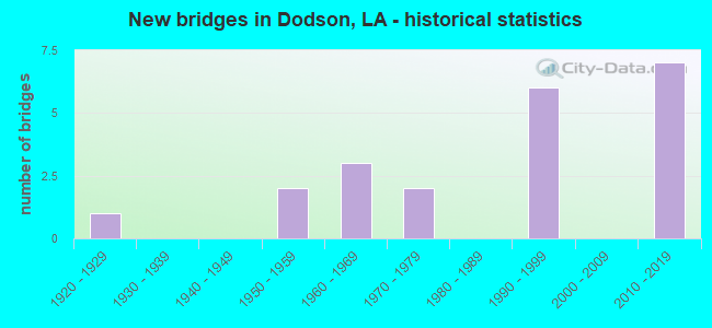
- New bridges - historical statistics
- 11920-1929
- 21950-1959
- 31960-1969
- 21970-1979
- 61990-1999
- 72010-2019


- Bridge Condition - Deck
- 50.0%Good
- 12.5%Satisfactory
- 37.5%Fair

- Bridge Condition - Superstructure
- 50.0%Good
- 25.0%Satisfactory
- 18.8%Fair
- 6.3%Poor

- Bridge Condition - Substructure
- 12.5%Very good
- 50.0%Good
- 18.8%Fair
- 18.8%Poor

- Bridge Condition - Channel
- 5.3%Excellent
- 31.6%Very good
- 15.8%Good
- 21.1%Satisfactory
- 26.3%Fair

- Bridge Condition - Culverts
- 20.0%Very good
- 60.0%Good
- 20.0%Fair
Find on map >> Show street view
Structure Number: 86400000045182, Location: 2.26 MILE NORTH OF LA 505 (Lat: 32.037139, Lng: -92.653400), Route carried "on" structure: US 167, Year Built: 1976, Status: Open, Structure Length: 10.67m (35.01ft), Average Daily Traffic: 2,750 (year 2016), Truck Traffic: 15%, Average Future Daily Traffic: 5,610 (year 2036), Design Load: HS 20, Features Intersected: KCS RR
Minimum Vertical Clearance: 30+ m (98+ ft), Kilometerpoint: 13.628, Lanes on structure: 2, Lanes under structure: 1, Base Highway Network: Yes (Inventory Route: 23-05-2, Subroute: 10), Owner: State Highway Agency, Approaching Roadway Width: 13.4m (44.0ft), Skew: 34 degrees, Material/Design: Steel, Design/Construction: Stringer/Multi-beam, Number Of Spans In Main Unit: 7, Length of Maximum Span: 18.3m (60.0ft), Curb-To-Curb Width: 9.2m (30.2ft), Out-to-Out Width: 10.1m (33.1ft)
Condition: Deck: Fair, Superstructure: Poor, Substructure: Poor, Operating Rating: 60.8 metric tons, Method Used To Determine Operating Rating: Load Factor (LF), Inventory Rating: 36.3 metric tons, Method Used To Determine Inventory Rating: Load Factor (LF), Structural Evaluation: Meets minimum limits, Deck Geometry: Meets minimum limits, Underclear: Somewhat better than minimum adequacy, Approach Roadway Alignment: Equal to present desirable criteria, Designated Inspection Frequency: Every 24 months, Inspection Date: December 2021, Deck Structure Type: Concrete Cast-file-Place, Wearing Surface/Protective System: Wearing Surface: Monolithic Concrete
Find on map >> Show street view
Structure Number: 8640000004519, Location: 2.76 MI. NORTH OF LA 505 (Lat: 32.042739, Lng: -92.652200), Route carried "on" structure: US 167, Year Built: 1960, Year Reconstructed: 2010, Status: Open, Structure Length: 0.67m (2.20ft), Average Daily Traffic: 5,500 (year 2016), Truck Traffic: 15%, Average Future Daily Traffic: 9,350 (year 2036), Design Load: HS 20, Features Intersected: CREEK
Minimum Vertical Clearance: 30+ m (98+ ft), Kilometerpoint: 14.323, Lanes on structure: 4, Base Highway Network: Yes (Inventory Route: 23-05-1, Subroute: 10), Owner: State Highway Agency, Approaching Roadway Width: 23.5m (77.1ft), Skew: 30 degrees, Material/Design: Concrete, Design/Construction: Culvert, Number Of Spans In Main Unit: 4, Length of Maximum Span: 1.5m (4.9ft)
Condition: Channel: Good, Culverts: Good, Operating Rating: 42.1 metric tons, Method Used To Determine Operating Rating: Load and Resistance Factor Rating (LRFR) rating reported by rating factor(RF) method using HL-93 loadings, Inventory Rating: 32.4 metric tons, Method Used To Determine Inventory Rating: Load and Resistance Factor Rating (LRFR) rating reported by rating factor(RF) method using HL-93 loadings, Structural Evaluation: Better than present minimum criteria, Waterway Adequacy: Meets minimum limits, Approach Roadway Alignment: Equal to present minimum criteria, Designated Inspection Frequency: Every 24 months, Inspection Date: December 2021, Deck Structure Type: Concrete Cast-file-Place
Find on map >> Show street view
Structure Number: 864000000452, Location: 2.1 MI NORTH OF LA 126 (Lat: 32.096511, Lng: -92.667800), Route carried "on" structure: US 167, Year Built: 1924, Status: Open, Structure Length: 1.01m (3.31ft), Average Daily Traffic: 2,450 (year 2016), Truck Traffic: 15%, Average Future Daily Traffic: 5,100 (year 2036), Design Load: H 15, Features Intersected: CREEK
Minimum Vertical Clearance: 30+ m (98+ ft), Kilometerpoint: 6.606, Lanes on structure: 2, Base Highway Network: Yes (Inventory Route: 23-05-2, Subroute: 10), Owner: State Highway Agency, Approaching Roadway Width: 11.0m (36.1ft), Skew: 30 degrees, Material/Design: Concrete, Design/Construction: Culvert, Number Of Spans In Main Unit: 5, Length of Maximum Span: 1.8m (5.9ft), Curb-To-Curb Width: 11.0m (36.1ft), Out-to-Out Width: 13.4m (44.0ft)
Condition: Channel: Fair, Culverts: Good, Operating Rating: 42.1 metric tons, Method Used To Determine Operating Rating: Load and Resistance Factor Rating (LRFR) rating reported by rating factor(RF) method using HL-93 loadings, Inventory Rating: 32.4 metric tons, Method Used To Determine Inventory Rating: Load and Resistance Factor Rating (LRFR) rating reported by rating factor(RF) method using HL-93 loadings, Structural Evaluation: Better than present minimum criteria, Deck Geometry: Equal to present minimum criteria, Waterway Adequacy: Meets minimum limits, Approach Roadway Alignment: Somewhat better than minimum adequacy, Designated Inspection Frequency: Every 24 months, Inspection Date: November 2021, Deck Structure Type: Concrete Cast-file-Place
Find on map >> Show street view
Structure Number: 8640000004521, Location: 2.7 MI NORTH OF LA 126 (Lat: 32.103750, Lng: -92.678500), Route carried "on" structure: US 167, Year Built: 1952, Status: Open, Structure Length: 7.28m (23.88ft), Average Daily Traffic: 4,900 (year 2016), Truck Traffic: 15%, Average Future Daily Traffic: 5,100 (year 2036), Design Load: HS 20, Features Intersected: BIG CREEK
Minimum Vertical Clearance: 30+ m (98+ ft), Kilometerpoint: 5.272, Lanes on structure: 2, Base Highway Network: Yes (Inventory Route: 23-05-2, Subroute: 10), Owner: State Highway Agency, Approaching Roadway Width: 12.2m (40.0ft), Skew: 30 degrees, Material/Design: Concrete, Design/Construction: Slab, Number Of Spans In Main Unit: 12, Length of Maximum Span: 6.1m (20.0ft), Curb-To-Curb Width: 7.9m (25.9ft), Out-to-Out Width: 9.8m (32.2ft)
Condition: Deck: Fair, Superstructure: Fair, Substructure: Fair, Channel: Fair, Operating Rating: 35.3 metric tons, Method Used To Determine Operating Rating: Load and Resistance Factor Rating (LRFR) rating reported by rating factor(RF) method using HL-93 loadings, Inventory Rating: 27.2 metric tons, Method Used To Determine Inventory Rating: Load and Resistance Factor Rating (LRFR) rating reported by rating factor(RF) method using HL-93 loadings, Structural Evaluation: Somewhat better than minimum adequacy, Deck Geometry: High priority of corrective action, Waterway Adequacy: Better than present minimum criteria, Approach Roadway Alignment: Equal to present desirable criteria, Length Of Structure Improvement: 8.20m (26.90ft), Designated Inspection Frequency: Every 24 months, Underwater Inspection Frequency: Every 60 months, Inspection Date: November 2021, Underwater Inspection Date: March 2018, Bridge Improvement Cost: $699,000, Total Project Cost: $1,048,000 ( Estimate for 2016), Deck Structure Type: Concrete Cast-file-Place, Wearing Surface/Protective System: Wearing Surface: Bituminous
Find on map >> Show street view
Structure Number: 8640000004522, Location: 2.46 MILE NORTH OF LA 126 (Lat: 32.107181, Lng: -92.680400), Route carried "on" structure: US 167, Year Built: 1952, Status: Open, Structure Length: 4.21m (13.81ft), Average Daily Traffic: 4,900 (year 2016), Truck Traffic: 15%, Average Future Daily Traffic: 5,100 (year 2036), Design Load: HS 20, Features Intersected: BIG CREEK RELIEF
Minimum Vertical Clearance: 30+ m (98+ ft), Kilometerpoint: 4.854, Lanes on structure: 2, Base Highway Network: Yes (Inventory Route: 23-05-2, Subroute: 10), Owner: State Highway Agency, Approaching Roadway Width: 12.2m (40.0ft), Skew: 30 degrees, Material/Design: Concrete, Design/Construction: Slab, Number Of Spans In Main Unit: 7, Length of Maximum Span: 6.1m (20.0ft), Curb-To-Curb Width: 7.9m (25.9ft), Out-to-Out Width: 9.8m (32.2ft)
Condition: Deck: Fair, Superstructure: Fair, Substructure: Fair, Channel: Satisfactory, Operating Rating: 33.6 metric tons, Method Used To Determine Operating Rating: Load Factor (LF), Inventory Rating: 20.0 metric tons, Method Used To Determine Inventory Rating: Load Factor (LF), Structural Evaluation: Somewhat better than minimum adequacy, Deck Geometry: High priority of corrective action, Waterway Adequacy: Better than present minimum criteria, Approach Roadway Alignment: Superior to present desirable criteria, Length Of Structure Improvement: 5.12m (16.80ft), Designated Inspection Frequency: Every 24 months, Inspection Date: November 2021, Bridge Improvement Cost: $436,000, Total Project Cost: $654,000 ( Estimate for 2016), Deck Structure Type: Concrete Cast-file-Place, Wearing Surface/Protective System: Wearing Surface: Bituminous
Find on map >> Show street view
Structure Number: 86400000080555, Location: 2.18 MI. NORTH OF LA 126 (Lat: 32.103289, Lng: -92.677800), Route carried "on" structure: US 167, Year Built: 2010, Status: Open, Structure Length: 7.32m (24.02ft), Average Daily Traffic: 2,450 (year 2016), Truck Traffic: 15%, Average Future Daily Traffic: 5,100 (year 2036), Design Load: HS 20, Features Intersected: BIG CREEK
Minimum Vertical Clearance: 30+ m (98+ ft), Kilometerpoint: 21.942, Lanes on structure: 2, Base Highway Network: Yes (Inventory Route: 23-05-1, Subroute: 10), Owner: State Highway Agency, Approaching Roadway Width: 11.0m (36.1ft), Skew: 30 degrees, Material/Design: Concrete, Design/Construction: Slab, Number Of Spans In Main Unit: 12, Length of Maximum Span: 6.1m (20.0ft), Curb-To-Curb Width: 12.0m (39.4ft), Out-to-Out Width: 13.0m (42.7ft)
Condition: Deck: Good, Superstructure: Good, Substructure: Very good, Channel: Very good, Operating Rating: 45.0 metric tons, Method Used To Determine Operating Rating: Load and Resistance Factor Rating (LRFR) rating reported by rating factor(RF) method using HL-93 loadings, Inventory Rating: 35.0 metric tons, Method Used To Determine Inventory Rating: Load and Resistance Factor Rating (LRFR) rating reported by rating factor(RF) method using HL-93 loadings, Structural Evaluation: Better than present minimum criteria, Deck Geometry: Better than present minimum criteria, Waterway Adequacy: Equal to present minimum criteria, Approach Roadway Alignment: Equal to present desirable criteria, Designated Inspection Frequency: Every 24 months, Inspection Date: November 2021, Deck Structure Type: Concrete Cast-file-Place, Wearing Surface/Protective System: Wearing Surface: Monolithic Concrete
Find on map >> Show street view
Structure Number: 86400000080556, Location: 2.46 MI. NORTH OF LA 126 (Lat: 32.106969, Lng: -92.679800), Route carried "on" structure: US 167, Year Built: 2010, Status: Open, Structure Length: 4.27m (14.01ft), Average Daily Traffic: 2,450 (year 2016), Truck Traffic: 15%, Average Future Daily Traffic: 5,100 (year 2036), Design Load: HS 20, Features Intersected: BIG CREEK RELIEF
Minimum Vertical Clearance: 30+ m (98+ ft), Kilometerpoint: 22.391, Lanes on structure: 2, Base Highway Network: Yes (Inventory Route: 23-05-1, Subroute: 10), Owner: State Highway Agency, Approaching Roadway Width: 11.0m (36.1ft), Skew: 30 degrees, Material/Design: Concrete, Design/Construction: Slab, Number Of Spans In Main Unit: 7, Length of Maximum Span: 6.1m (20.0ft), Curb-To-Curb Width: 12.0m (39.4ft), Out-to-Out Width: 13.0m (42.7ft)
Condition: Deck: Good, Superstructure: Good, Substructure: Very good, Channel: Very good, Operating Rating: 36.3 metric tons, Method Used To Determine Operating Rating: Load and Resistance Factor Rating (LRFR) rating reported by rating factor(RF) method using HL-93 loadings, Inventory Rating: 28.2 metric tons, Method Used To Determine Inventory Rating: Load and Resistance Factor Rating (LRFR) rating reported by rating factor(RF) method using HL-93 loadings, Structural Evaluation: Better than present minimum criteria, Deck Geometry: Better than present minimum criteria, Waterway Adequacy: Equal to present minimum criteria, Approach Roadway Alignment: Equal to present desirable criteria, Designated Inspection Frequency: Every 24 months, Inspection Date: November 2021, Deck Structure Type: Concrete Cast-file-Place, Wearing Surface/Protective System: Wearing Surface: Monolithic Concrete
Find on map >> Show street view
Structure Number: 86400000080557, Location: 1.39 MI. NORTH OF LA 126 (Lat: 32.096789, Lng: -92.667500), Route carried "on" structure: US 167, Year Built: 2010, Status: Open, Structure Length: 1.07m (3.51ft), Average Daily Traffic: 2,450 (year 2016), Truck Traffic: 15%, Average Future Daily Traffic: 5,100 (year 2036), Design Load: HS 20, Features Intersected: CREEK
Minimum Vertical Clearance: 30+ m (98+ ft), Kilometerpoint: 20.701, Lanes on structure: 2, Base Highway Network: Yes (Inventory Route: 23-05-1, Subroute: 10), Owner: State Highway Agency, Approaching Roadway Width: 11.0m (36.1ft), Skew: 30 degrees, Material/Design: Concrete, Design/Construction: Culvert, Number Of Spans In Main Unit: 5, Length of Maximum Span: 1.8m (5.9ft)
Condition: Channel: Very good, Culverts: Very good, Operating Rating: 42.1 metric tons, Method Used To Determine Operating Rating: Load and Resistance Factor Rating (LRFR) rating reported by rating factor(RF) method using HL-93 loadings, Inventory Rating: 32.4 metric tons, Method Used To Determine Inventory Rating: Load and Resistance Factor Rating (LRFR) rating reported by rating factor(RF) method using HL-93 loadings, Structural Evaluation: Equal to present desirable criteria, Waterway Adequacy: Equal to present minimum criteria, Approach Roadway Alignment: Equal to present desirable criteria, Designated Inspection Frequency: Every 24 months, Inspection Date: November 2021, Deck Structure Type: Concrete Precast Panels
Find on map >> Show street view
Structure Number: 8640000008056, Location: 2.26 MI. NORTH OF LA 505 (Lat: 32.035711, Lng: -92.654000), Route carried "on" structure: US 167, Year Built: 2010, Status: Open, Structure Length: 12.44m (40.81ft), Average Daily Traffic: 5,500 (year 2016), Truck Traffic: 15%, Average Future Daily Traffic: 5,610 (year 2036), Design Load: HS 20, Features Intersected: KCS RAILROAD
Minimum Vertical Clearance: 30+ m (98+ ft), Kilometerpoint: 13.473, Lanes on structure: 2, Lanes under structure: 2, Base Highway Network: Yes (Inventory Route: 23-05-1, Subroute: 10), Owner: State Highway Agency, Approaching Roadway Width: 12.2m (40.0ft), Skew: 30 degrees, Material/Design: Prestressed concrete continuous, Design/Construction: Stringer/Multi-beam, Number Of Spans In Main Unit: 4, Length of Maximum Span: 31.1m (102.0ft), Curb-To-Curb Width: 12.0m (39.4ft), Out-to-Out Width: 13.0m (42.7ft)
Condition: Deck: Good, Superstructure: Good, Substructure: Good, Operating Rating: 59.9 metric tons, Method Used To Determine Operating Rating: Load and Resistance Factor Rating (LRFR) rating reported by rating factor(RF) method using HL-93 loadings, Inventory Rating: 37.9 metric tons, Method Used To Determine Inventory Rating: Load and Resistance Factor Rating (LRFR) rating reported by rating factor(RF) method using HL-93 loadings, Structural Evaluation: Better than present minimum criteria, Deck Geometry: Somewhat better than minimum adequacy, Underclear: Superior to present desirable criteria, Approach Roadway Alignment: Equal to present desirable criteria, Designated Inspection Frequency: Every 24 months, Inspection Date: December 2021, Deck Structure Type: Concrete Cast-file-Place, Wearing Surface/Protective System: Wearing Surface: Monolithic Concrete
Find on map >> Show street view
Structure Number: 86400000080599, Location: 1.33 MI W OF LA 34 (Lat: 32.059731, Lng: -92.607369), Route carried "on" structure: State highway 1236, Year Built: 2016, Status: Open, Structure Length: 4.88m (16.01ft), Average Daily Traffic: 750 (year 2016), Truck Traffic: 14%, Average Future Daily Traffic: 1,375 (year 2033), Design Load: HL 93, Features Intersected: LITTLE KIESCHE CREEK
Minimum Vertical Clearance: 30+ m (98+ ft), Kilometerpoint: 5.535, Lanes on structure: 2, Owner: State Highway Agency, Approaching Roadway Width: 7.9m (25.9ft), Material/Design: Concrete, Design/Construction: Slab, Number Of Spans In Main Unit: 8, Length of Maximum Span: 6.1m (20.0ft), Curb-To-Curb Width: 10.9m (35.8ft), Out-to-Out Width: 11.6m (38.1ft)
Condition: Deck: Good, Superstructure: Good, Substructure: Good, Channel: Excellent, Operating Rating: 59.9 metric tons, Method Used To Determine Operating Rating: Load and Resistance Factor Rating (LRFR) rating reported by rating factor(RF) method using HL-93 loadings, Inventory Rating: 46.3 metric tons, Method Used To Determine Inventory Rating: Load and Resistance Factor Rating (LRFR) rating reported by rating factor(RF) method using HL-93 loadings, Structural Evaluation: Better than present minimum criteria, Deck Geometry: Equal to present minimum criteria, Waterway Adequacy: Superior to present desirable criteria, Approach Roadway Alignment: Equal to present desirable criteria, Designated Inspection Frequency: Every 24 months, Inspection Date: September 2021, Deck Structure Type: Concrete Cast-file-Place
Find on map >> Show street view
Structure Number: 86400000080601, Location: 2.85 MILES EAST OF US 167 (Lat: 32.061100, Lng: -92.616400), Route carried "on" structure: State highway 1236, Year Built: 2015, Status: Open, Structure Length: 3.05m (10.01ft), Average Daily Traffic: 750 (year 2016), Truck Traffic: 14%, Average Future Daily Traffic: 1,275 (year 2036), Design Load: HL 93, Features Intersected: UNNAMED CREEK
Minimum Vertical Clearance: 30+ m (98+ ft), Kilometerpoint: 4.506, Lanes on structure: 2, Owner: State Highway Agency, Approaching Roadway Width: 10.7m (35.1ft), Skew: 30 degrees, Material/Design: Concrete, Design/Construction: Slab, Number Of Spans In Main Unit: 5, Length of Maximum Span: 6.1m (20.0ft), Curb-To-Curb Width: 10.8m (35.4ft), Out-to-Out Width: 11.9m (39.0ft)
Condition: Deck: Good, Superstructure: Good, Substructure: Good, Channel: Very good, Operating Rating: 59.9 metric tons, Method Used To Determine Operating Rating: Load and Resistance Factor Rating (LRFR) rating reported by rating factor(RF) method using HL-93 loadings, Inventory Rating: 46.3 metric tons, Method Used To Determine Inventory Rating: Load and Resistance Factor Rating (LRFR) rating reported by rating factor(RF) method using HL-93 loadings, Structural Evaluation: Better than present minimum criteria, Deck Geometry: Equal to present minimum criteria, Waterway Adequacy: Equal to present desirable criteria, Approach Roadway Alignment: Superior to present desirable criteria, Designated Inspection Frequency: Every 24 months, Inspection Date: September 2021, Deck Structure Type: Concrete Cast-file-Place, Wearing Surface/Protective System: Wearing Surface: Monolithic Concrete
Find on map >> Show street view
Structure Number: 86400000080634, Location: 0.09 MILES EAST OF US 167 (Lat: 32.063350, Lng: -92.659300), Route carried "on" structure: State highway 1236, Year Built: 2014, Status: Open, Structure Length: 3.05m (10.01ft), Average Daily Traffic: 750 (year 2016), Truck Traffic: 14%, Average Future Daily Traffic: 1,275 (year 2036), Design Load: HL 93, Features Intersected: BRUSHY CREEK
Minimum Vertical Clearance: 30+ m (98+ ft), Kilometerpoint: 0.145, Lanes on structure: 2, Owner: State Highway Agency, Approaching Roadway Width: 7.9m (25.9ft), Skew: 30 degrees, Material/Design: Concrete, Design/Construction: Slab, Number Of Spans In Main Unit: 5, Length of Maximum Span: 6.1m (20.0ft), Curb-To-Curb Width: 10.9m (35.8ft), Out-to-Out Width: 11.8m (38.7ft)
Condition: Deck: Good, Superstructure: Good, Substructure: Good, Channel: Very good, Operating Rating: 59.9 metric tons, Method Used To Determine Operating Rating: Load and Resistance Factor Rating (LRFR) rating reported by rating factor(RF) method using HL-93 loadings, Inventory Rating: 46.3 metric tons, Method Used To Determine Inventory Rating: Load and Resistance Factor Rating (LRFR) rating reported by rating factor(RF) method using HL-93 loadings, Structural Evaluation: Better than present minimum criteria, Deck Geometry: Equal to present minimum criteria, Waterway Adequacy: Equal to present desirable criteria, Approach Roadway Alignment: Superior to present desirable criteria, Designated Inspection Frequency: Every 24 months, Inspection Date: September 2021, Deck Structure Type: Concrete Cast-file-Place, Wearing Surface/Protective System: Wearing Surface: Monolithic Concrete
Find on map >> Show street view
Structure Number: 86400910608381, Location: 3.7 MILES EAST OF LA 505 (Lat: 32.101681, Lng: -92.707000), Route carried "on" structure: State highway 126, Year Built: 1992, Status: Open, Structure Length: 3.66m (12.01ft), Average Daily Traffic: 590 (year 2016), Truck Traffic: 14%, Average Future Daily Traffic: 1,003 (year 2036), Design Load: HS 20, Features Intersected: CANEY CREEK
Minimum Vertical Clearance: 30+ m (98+ ft), Kilometerpoint: 13.517, Lanes on structure: 2, Owner: State Highway Agency, Approaching Roadway Width: 7.3m (24.0ft), Skew: 30 degrees, Material/Design: Concrete, Design/Construction: Slab, Number Of Spans In Main Unit: 6, Length of Maximum Span: 6.1m (20.0ft), Curb-To-Curb Width: 9.1m (29.9ft), Out-to-Out Width: 10.1m (33.1ft)
Condition: Deck: Satisfactory, Superstructure: Satisfactory, Substructure: Good, Channel: Very good, Operating Rating: 66.2 metric tons, Method Used To Determine Operating Rating: Load Factor (LF), Inventory Rating: 39.9 metric tons, Method Used To Determine Inventory Rating: Load Factor (LF), Structural Evaluation: Equal to present minimum criteria, Deck Geometry: Equal to present minimum criteria, Waterway Adequacy: Equal to present desirable criteria, Approach Roadway Alignment: Equal to present desirable criteria, Designated Inspection Frequency: Every 24 months, Inspection Date: July 2021, Deck Structure Type: Concrete Cast-file-Place, Wearing Surface/Protective System: Wearing Surface: Monolithic Concrete
Find on map >> Show street view
Structure Number: 86400910609651, Location: .6 MI EAST OF LA 1234 (Lat: 32.095000, Lng: -92.689700), Route carried "on" structure: State highway 126, Year Built: 1992, Status: Open, Structure Length: 4.88m (16.01ft), Average Daily Traffic: 590 (year 2016), Truck Traffic: 14%, Average Future Daily Traffic: 1,003 (year 2036), Design Load: HS 20, Features Intersected: BIG CREEK
Minimum Vertical Clearance: 30+ m (98+ ft), Kilometerpoint: 15.545, Lanes on structure: 2, Owner: State Highway Agency, Approaching Roadway Width: 7.3m (24.0ft), Skew: 30 degrees, Material/Design: Concrete, Design/Construction: Slab, Number Of Spans In Main Unit: 8, Length of Maximum Span: 6.1m (20.0ft), Curb-To-Curb Width: 9.1m (29.9ft), Out-to-Out Width: 10.1m (33.1ft)
Condition: Deck: Good, Superstructure: Good, Substructure: Good, Channel: Satisfactory, Operating Rating: 66.2 metric tons, Method Used To Determine Operating Rating: Load Factor (LF), Inventory Rating: 39.0 metric tons, Method Used To Determine Inventory Rating: Load Factor (LF), Structural Evaluation: Better than present minimum criteria, Deck Geometry: Equal to present minimum criteria, Waterway Adequacy: Superior to present desirable criteria, Approach Roadway Alignment: Equal to present desirable criteria, Designated Inspection Frequency: Every 24 months, Inspection Date: July 2021, Deck Structure Type: Concrete Cast-file-Place, Wearing Surface/Protective System: Wearing Surface: Monolithic Concrete
Find on map >> Show street view
Structure Number: 86400910609891, Location: .8 MI EAST OF LA 1234 (Lat: 32.092339, Lng: -92.686811), Route carried "on" structure: State highway 126, Year Built: 1992, Status: Open, Structure Length: 4.88m (16.01ft), Average Daily Traffic: 590 (year 2016), Truck Traffic: 14%, Average Future Daily Traffic: 1,003 (year 2036), Design Load: HS 20, Features Intersected: BIG CREEK RELIEF
Minimum Vertical Clearance: 30+ m (98+ ft), Kilometerpoint: 15.545, Lanes on structure: 2, Owner: State Highway Agency, Approaching Roadway Width: 7.3m (24.0ft), Skew: 30 degrees, Material/Design: Concrete, Design/Construction: Slab, Number Of Spans In Main Unit: 8, Length of Maximum Span: 6.1m (20.0ft), Curb-To-Curb Width: 9.1m (29.9ft), Out-to-Out Width: 10.1m (33.1ft)
Condition: Deck: Satisfactory, Superstructure: Satisfactory, Substructure: Good, Channel: Satisfactory, Operating Rating: 66.2 metric tons, Method Used To Determine Operating Rating: Load Factor (LF), Inventory Rating: 39.9 metric tons, Method Used To Determine Inventory Rating: Load Factor (LF), Structural Evaluation: Equal to present minimum criteria, Deck Geometry: Equal to present minimum criteria, Waterway Adequacy: Superior to present desirable criteria, Approach Roadway Alignment: Equal to present desirable criteria, Designated Inspection Frequency: Every 24 months, Inspection Date: July 2021, Deck Structure Type: Concrete Cast-file-Place
Find on map >> Show street view
Structure Number: 86400910700551, Location: 0.55 MI EAST JCT US 167 (Lat: 32.079950, Lng: -92.651400), Route carried "on" structure: State highway 126, Year Built: 1996, Status: Open, Structure Length: 0.82m (2.69ft), Average Daily Traffic: 1,100 (year 2016), Truck Traffic: 14%, Average Future Daily Traffic: 1,870 (year 2036), Design Load: HS 20, Features Intersected: BRUSHY CREEK
Minimum Vertical Clearance: 30+ m (98+ ft), Kilometerpoint: 0.877, Lanes on structure: 2, Owner: State Highway Agency, Approaching Roadway Width: 9.1m (29.9ft), Skew: 30 degrees, Material/Design: Steel, Design/Construction: Culvert, Number Of Spans In Main Unit: 4, Length of Maximum Span: 1.5m (4.9ft)
Condition: Channel: Fair, Culverts: Fair, Operating Rating: 97.2 metric tons, Method Used To Determine Operating Rating: Load and Resistance Factor Rating (LRFR) rating reported by rating factor(RF) method using HL-93 loadings, Inventory Rating: 74.5 metric tons, Method Used To Determine Inventory Rating: Load and Resistance Factor Rating (LRFR) rating reported by rating factor(RF) method using HL-93 loadings, Structural Evaluation: Somewhat better than minimum adequacy, Waterway Adequacy: Equal to present desirable criteria, Approach Roadway Alignment: Equal to present desirable criteria, Designated Inspection Frequency: Every 24 months, Inspection Date: July 2021
Find on map >> Show street view
Structure Number: 86400910702201, Location: 2.2 MI EAST JCT US 167 (Lat: 32.085089, Lng: -92.629500), Route carried "on" structure: State highway 126, Year Built: 1996, Status: Open, Structure Length: 0.73m (2.40ft), Average Daily Traffic: 870 (year 2016), Truck Traffic: 14%, Average Future Daily Traffic: 1,479 (year 2036), Design Load: HS 20, Features Intersected: KIESCHE CREEK TRIB.
Minimum Vertical Clearance: 30+ m (98+ ft), Kilometerpoint: 3.528, Lanes on structure: 2, Owner: State Highway Agency, Approaching Roadway Width: 8.5m (27.9ft), Skew: 6 degrees, Material/Design: Concrete, Design/Construction: Culvert, Number Of Spans In Main Unit: 3, Length of Maximum Span: 2.1m (6.9ft)
Condition: Channel: Fair, Culverts: Good, Operating Rating: 42.1 metric tons, Method Used To Determine Operating Rating: Load and Resistance Factor Rating (LRFR) rating reported by rating factor(RF) method using HL-93 loadings, Inventory Rating: 32.4 metric tons, Method Used To Determine Inventory Rating: Load and Resistance Factor Rating (LRFR) rating reported by rating factor(RF) method using HL-93 loadings, Structural Evaluation: Better than present minimum criteria, Waterway Adequacy: Superior to present desirable criteria, Approach Roadway Alignment: Equal to present desirable criteria, Designated Inspection Frequency: Every 24 months, Inspection Date: July 2021, Deck Structure Type: Concrete Cast-file-Place
Find on map >> Show street view
Structure Number: 86400910702621, Location: 2.62 MI. EAST OF US 167 (Lat: 32.088289, Lng: -92.624600), Route carried "on" structure: State highway 126, Year Built: 1974, Status: Posted for load, Structure Length: 2.35m (7.71ft), Average Daily Traffic: 870 (year 2016), Truck Traffic: 14%, Average Future Daily Traffic: 1,479 (year 2036), Design Load: H 15, Features Intersected: LITTLE KIESCHE CREEK
Minimum Vertical Clearance: 30+ m (98+ ft), Kilometerpoint: 4.210, Lanes on structure: 2, Owner: State Highway Agency, Approaching Roadway Width: 8.5m (27.9ft), Skew: 30 degrees, Material/Design: Wood or Timber, Design/Construction: Stringer/Multi-beam, Number Of Spans In Main Unit: 4, Length of Maximum Span: 5.8m (19.0ft), Curb-To-Curb Width: 8.5m (27.9ft), Out-to-Out Width: 9.0m (29.5ft)
Condition: Deck: Fair, Superstructure: Fair, Substructure: Poor, Channel: Good, Operating Rating: 27.2 metric tons, Method Used To Determine Operating Rating: Allowable Stress (AS), Inventory Rating: 19.0 metric tons, Method Used To Determine Inventory Rating: Allowable Stress (AS), Structural Evaluation: Meets minimum limits, Deck Geometry: Somewhat better than minimum adequacy, Waterway Adequacy: Equal to present desirable criteria, Approach Roadway Alignment: Equal to present desirable criteria, Bridge Posting: Required (Relationship of Operating Rating to Maximum Legal Load: 0.1 - 9.9% below), Length Of Structure Improvement: 3.11m (10.20ft), Designated Inspection Frequency: Every 24 months, Other Special Inspection Frequency: Every 12 months, Inspection Date: July 2021, Other Special Inspection Date: July 2020, Bridge Improvement Cost: $265,000, Total Project Cost: $397,000 ( Estimate for 2016), Deck Structure Type: Wood or Timber, Wearing Surface/Protective System: Wearing Surface: Bituminous
Find on map >> Show street view
Structure Number: 86400910704111, Location: 4.11 MI EAST OF US 167 (Lat: 32.088311, Lng: -92.599300), Route carried "on" structure: State highway 126, Year Built: 1996, Status: Open, Structure Length: 4.27m (14.01ft), Average Daily Traffic: 870 (year 2016), Truck Traffic: 14%, Average Future Daily Traffic: 1,479 (year 2036), Design Load: HS 20, Features Intersected: KIESCHE CREEK
Minimum Vertical Clearance: 30+ m (98+ ft), Kilometerpoint: 6.597, Lanes on structure: 2, Owner: State Highway Agency, Approaching Roadway Width: 9.1m (29.9ft), Skew: 30 degrees, Material/Design: Concrete, Design/Construction: Slab, Number Of Spans In Main Unit: 7, Length of Maximum Span: 6.1m (20.0ft), Curb-To-Curb Width: 9.0m (29.5ft), Out-to-Out Width: 10.0m (32.8ft)
Condition: Deck: Good, Superstructure: Good, Substructure: Good, Channel: Good, Operating Rating: 68.0 metric tons, Method Used To Determine Operating Rating: Load Factor (LF), Inventory Rating: 40.8 metric tons, Method Used To Determine Inventory Rating: Load Factor (LF), Structural Evaluation: Better than present minimum criteria, Deck Geometry: Somewhat better than minimum adequacy, Approach Roadway Alignment: Superior to present desirable criteria, Designated Inspection Frequency: Every 24 months, Inspection Date: July 2021, Deck Structure Type: Concrete Cast-file-Place, Wearing Surface/Protective System: Wearing Surface: Monolithic Concrete
Find on map >> Show street view
Structure Number: 86408641401221, Location: 1.22 MI NORTH OF LA 126 (Lat: 32.112319, Lng: -92.708900), Route carried "on" structure: State highway 1234, Year Built: 1967, Status: Posted for load, Structure Length: 1.16m (3.81ft), Average Daily Traffic: 360 (year 2016), Truck Traffic: 10%, Average Future Daily Traffic: 612 (year 2036), Design Load: H 15, Features Intersected: DRAIN
Minimum Vertical Clearance: 30+ m (98+ ft), Kilometerpoint: 1.951, Lanes on structure: 2, Owner: State Highway Agency, Approaching Roadway Width: 8.5m (27.9ft), Skew: 30 degrees, Material/Design: Wood or Timber, Design/Construction: Stringer/Multi-beam, Number Of Spans In Main Unit: 2, Length of Maximum Span: 5.8m (19.0ft), Curb-To-Curb Width: 7.3m (24.0ft), Out-to-Out Width: 7.8m (25.6ft)
Condition: Deck: Fair, Superstructure: Satisfactory, Substructure: Fair, Channel: Satisfactory, Operating Rating: 24.5 metric tons, Method Used To Determine Operating Rating: Allowable Stress (AS), Inventory Rating: 18.1 metric tons, Method Used To Determine Inventory Rating: Allowable Stress (AS), Structural Evaluation: Somewhat better than minimum adequacy, Deck Geometry: Somewhat better than minimum adequacy, Waterway Adequacy: Equal to present minimum criteria, Approach Roadway Alignment: Better than present minimum criteria, Bridge Posting: Required (Relationship of Operating Rating to Maximum Legal Load: 0.1 - 9.9% below), Length Of Structure Improvement: 1.80m (5.91ft), Designated Inspection Frequency: Every 24 months, Inspection Date: August 2021, Bridge Improvement Cost: $153,000, Total Project Cost: $229,000 ( Estimate for 2016), Deck Structure Type: Wood or Timber, Wearing Surface/Protective System: Wearing Surface: Bituminous
Find on map >> Show street view
Structure Number: 86408641401761, Location: 1.76 MI NORTH OF LA 126 (Lat: 32.116181, Lng: -92.716600), Route carried "on" structure: State highway 1234, Year Built: 1967, Status: Open, Structure Length: 1.16m (3.81ft), Average Daily Traffic: 360 (year 2016), Truck Traffic: 10%, Average Future Daily Traffic: 612 (year 2036), Design Load: H 15, Features Intersected: DRAIN
Minimum Vertical Clearance: 30+ m (98+ ft), Kilometerpoint: 2.826, Lanes on structure: 2, Owner: State Highway Agency, Approaching Roadway Width: 6.3m (20.7ft), Skew: 30 degrees, Material/Design: Wood or Timber, Design/Construction: Stringer/Multi-beam, Number Of Spans In Main Unit: 2, Length of Maximum Span: 5.8m (19.0ft), Curb-To-Curb Width: 7.5m (24.6ft), Out-to-Out Width: 8.0m (26.2ft)
Condition: Deck: Fair, Superstructure: Satisfactory, Substructure: Poor, Channel: Fair, Operating Rating: 29.0 metric tons, Method Used To Determine Operating Rating: Allowable Stress (AS), Inventory Rating: 20.9 metric tons, Method Used To Determine Inventory Rating: Allowable Stress (AS), Structural Evaluation: Meets minimum limits, Deck Geometry: Somewhat better than minimum adequacy, Waterway Adequacy: Somewhat better than minimum adequacy, Approach Roadway Alignment: Equal to present minimum criteria, Length Of Structure Improvement: 1.80m (5.91ft), Designated Inspection Frequency: Every 24 months, Other Special Inspection Frequency: Every 12 months, Inspection Date: August 2021, Other Special Inspection Date: August 2020, Bridge Improvement Cost: $153,000, Total Project Cost: $229,000 ( Estimate for 2016), Deck Structure Type: Wood or Timber, Wearing Surface/Protective System: Wearing Surface: Bituminous