Bridge Statistics for Dimondale, Michigan (MI)
Condition, Traffic, Stress, Structural Evaluation, Project Costs
- National Bridge Inventory (NBI) Statistics
- 16Number of bridges
- 194ft / 59.4mTotal length
- $128,000Total costs
- 143,467Total average daily traffic
- 19,349Total average daily truck traffic
- National Bridge Inventory (NBI) Registered Bridges for Dimondale
- No street view available for this location
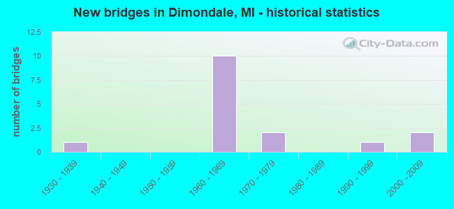
- New bridges - historical statistics
- 11930-1939
- 101960-1969
- 21970-1979
- 11990-1999
- 22000-2009

- Reconstructed bridges - Historical Statistics
- 11980-1989
- 11990-1999


- Bridge Condition - Deck
- 9.1%Very good
- 27.3%Good
- 63.6%Satisfactory

- Bridge Condition - Superstructure
- 54.5%Good
- 18.2%Satisfactory
- 27.3%Fair

- Bridge Condition - Substructure
- 45.5%Good
- 27.3%Satisfactory
- 18.2%Fair
- 9.1%Poor

- Bridge Condition - Channel
- 37.5%Good
- 50.0%Satisfactory
- 12.5%Poor
Find on map >> Show street view
Structure Number: 244, Location: FILLMORE TWP SEC 3 (Lat: 42.762031, Lng: -86.061719), Route carried "on" structure: County highway , Year Built: 1990, Status: Open, Structure Length: 1.22m (4.00ft), Average Daily Traffic: 896 (year 2013), Truck Traffic: 7%, Average Future Daily Traffic: 1,330 (year 2033), Design Load: HS 20, Features Intersected: N BR MACATAWA RIVER, Facility Carried by Structure: 147TH AVE
Minimum Vertical Clearance: 30.48m (100.00ft), Kilometerpoint: 2.684, Lanes on structure: 2, Owner: County Highway Agency, Approaching Roadway Width: 9.1m (29.9ft), Material/Design: Prestressed concrete, Design/Construction: Box Beam or Girders - Multiple, Number Of Spans In Main Unit: 1, Length of Maximum Span: 12.2m (40.0ft), Curb-To-Curb Width: 9.1m (29.9ft), Out-to-Out Width: 9.5m (31.2ft)
Condition: Deck: Very good, Superstructure: Good, Substructure: Poor, Channel: Poor, Operating Rating: 70.3 metric tons, Method Used To Determine Operating Rating: Load Factor (LF) rating reported by rating factor (RF) method using MS18 loading, Inventory Rating: 42.1 metric tons, Method Used To Determine Inventory Rating: Load Factor (LF) rating reported by rating factor (RF) method using MS18 loading, Structural Evaluation: Meets minimum limits, Deck Geometry: Equal to present minimum criteria, Waterway Adequacy: Equal to present desirable criteria, Approach Roadway Alignment: Equal to present desirable criteria, Designated Inspection Frequency: Every 24 months, Inspection Date: May 2021, Deck Structure Type: Concrete Precast Panels, Wearing Surface/Protective System: Wearing Surface: Bituminous, Membrane: Preformed Fabric
Find on map >> Show street view
Structure Number: 2304, Location: 0.5 MI S OF HOLT RD (Lat: 42.631169, Lng: -84.622689), Route carried "on" structure: State highway 99, Year Built: 1978, Status: Open, Structure Length: 5.49m (18.01ft), Average Daily Traffic: 4,238 (year 2007), Truck Traffic: 4%, Average Future Daily Traffic: 9,000 (year 2028), Design Load: HS 25 or greater, Features Intersected: GRAND RIVER
Minimum Vertical Clearance: 30.48m (100.00ft), Kilometerpoint: 24.395, Lanes on structure: 2, Base Highway Network: Yes (Inventory Route: 56, Subroute: 4), Owner: State Highway Agency, Approaching Roadway Width: 13.1m (43.0ft), Skew: 3 degrees, Material/Design: Steel, Design/Construction: Stringer/Multi-beam, Number Of Spans In Main Unit: 3, Length of Maximum Span: 18.3m (60.0ft), Curb-To-Curb Width: 12.8m (42.0ft), Out-to-Out Width: 14.0m (45.9ft)
Condition: Deck: Satisfactory, Superstructure: Good, Substructure: Satisfactory, Channel: Satisfactory, Operating Rating: 80.0 metric tons, Method Used To Determine Operating Rating: Load Factor (LF) rating reported by rating factor (RF) method using MS18 loading, Inventory Rating: 48.0 metric tons, Method Used To Determine Inventory Rating: Load Factor (LF) rating reported by rating factor (RF) method using MS18 loading, Structural Evaluation: Equal to present minimum criteria, Deck Geometry: Equal to present desirable criteria, Waterway Adequacy: Equal to present desirable criteria, Approach Roadway Alignment: Equal to present desirable criteria, Designated Inspection Frequency: Every 24 months, Inspection Date: May 2021, Deck Structure Type: Concrete Cast-file-Place, Wearing Surface/Protective System: Wearing Surface: Epoxy Overlay
Find on map >> Show street view
Structure Number: 2305, Location: 0.5 MI S OF HOLT RD (Lat: 42.630875, Lng: -84.623042), Route carried "on" structure: State highway 99, Year Built: 1978, Status: Open, Structure Length: 5.49m (18.01ft), Average Daily Traffic: 4,238 (year 2007), Truck Traffic: 4%, Average Future Daily Traffic: 5,508 (year 2018), Design Load: HS 25 or greater, Features Intersected: GRAND RIVER
Minimum Vertical Clearance: 30.48m (100.00ft), Kilometerpoint: 10.339, Lanes on structure: 2, Base Highway Network: Yes (Inventory Route: 192, Subroute: 2), Owner: State Highway Agency, Approaching Roadway Width: 13.4m (44.0ft), Skew: 3 degrees, Material/Design: Steel, Design/Construction: Stringer/Multi-beam, Number Of Spans In Main Unit: 3, Length of Maximum Span: 18.3m (60.0ft), Curb-To-Curb Width: 12.8m (42.0ft), Out-to-Out Width: 14.0m (45.9ft)
Condition: Deck: Satisfactory, Superstructure: Good, Substructure: Good, Channel: Satisfactory, Operating Rating: 80.0 metric tons, Method Used To Determine Operating Rating: Load Factor (LF) rating reported by rating factor (RF) method using MS18 loading, Inventory Rating: 48.0 metric tons, Method Used To Determine Inventory Rating: Load Factor (LF) rating reported by rating factor (RF) method using MS18 loading, Structural Evaluation: Better than present minimum criteria, Deck Geometry: Equal to present desirable criteria, Waterway Adequacy: Equal to present desirable criteria, Approach Roadway Alignment: Equal to present desirable criteria, Designated Inspection Frequency: Every 24 months, Inspection Date: May 2021, Bridge Improvement Cost: $183,000, Roadway Improvement Cost: $4,000, Total Project Cost: $51,000, Deck Structure Type: Concrete Cast-file-Place, Wearing Surface/Protective System: Wearing Surface: Epoxy Overlay
Find on map >> Show street view
Structure Number: 231, Location: 2.1 MI W OF INGHAM CO LIN (Lat: 42.669558, Lng: -84.645339), Route carried "on" structure: Interstate 96, Year Built: 1962, Status: Open, Structure Length: 12.18m (39.96ft), Average Daily Traffic: 21,057 (year 2007), Truck Traffic: 16%, Average Future Daily Traffic: 24,047 (year 2018), Design Load: HS 20+Mod, Features Intersected: GRAND RIV & BILLWOOD HWY
Minimum Vertical Clearance: 30.48m (100.00ft), Kilometerpoint: 11.758, Lanes on structure: 2, Lanes under structure: 2, Base Highway Network: Yes (Inventory Route: 56, Subroute: 5), Owner: State Highway Agency, Approaching Roadway Width: 12.8m (42.0ft), Skew: 3 degrees, Material/Design: Steel, Design/Construction: Stringer/Multi-beam, Number Of Spans In Main Unit: 3, Length of Maximum Span: 43.3m (142.1ft), Curb-To-Curb Width: 9.9m (32.5ft), Out-to-Out Width: 10.8m (35.4ft)
Condition: Deck: Satisfactory, Superstructure: Fair, Substructure: Fair, Channel: Good, Operating Rating: 69.3 metric tons, Method Used To Determine Operating Rating: Load Factor (LF) rating reported by rating factor (RF) method using MS18 loading, Inventory Rating: 41.5 metric tons, Method Used To Determine Inventory Rating: Load Factor (LF) rating reported by rating factor (RF) method using MS18 loading, Structural Evaluation: Somewhat better than minimum adequacy, Deck Geometry: Meets minimum limits, Underclear: High priority of corrective action, Waterway Adequacy: Equal to present desirable criteria, Approach Roadway Alignment: Equal to present desirable criteria, Designated Inspection Frequency: Every 24 months, Critical Feature Inspection Frequency: Every 15 months, Inspection Date: July 2021, Critical Feature Inspection Date: April 2021, Deck Structure Type: Concrete Cast-file-Place, Wearing Surface/Protective System: Wearing Surface: Integral Concrete, Deck Protection: Epoxy Coated Reinforcing
Find on map >> Show street view
Structure Number: 2312, Location: 2.0 MI W OF INGHAM CO LIN (Lat: 42.667144, Lng: -84.642267), Route carried "on" structure: County highway 2003, Year Built: 1962, Status: Open, Structure Length: 6.49m (21.29ft), Average Daily Traffic: 2,500 (year 1991), Truck Traffic: 3%, Average Future Daily Traffic: 2,875 (year 2011), Design Load: H 15, Features Intersected: I-96 EB, Facility Carried by Structure: CREYTS RD
Minimum Vertical Clearance: 30.48m (100.00ft), Kilometerpoint: 2.216, Lanes on structure: 2, Lanes under structure: 2, Owner: State Highway Agency, Approaching Roadway Width: 8.8m (28.9ft), Skew: 3 degrees, Material/Design: Steel, Design/Construction: Stringer/Multi-beam, Number Of Spans In Main Unit: 3, Length of Maximum Span: 21.9m (71.9ft), Curb-To-Curb Width: 8.7m (28.5ft), Out-to-Out Width: 10.0m (32.8ft)
Condition: Deck: Satisfactory, Superstructure: Fair, Substructure: Satisfactory, Operating Rating: 67.7 metric tons, Method Used To Determine Operating Rating: Load Factor (LF) rating reported by rating factor (RF) method using MS18 loading, Inventory Rating: 40.5 metric tons, Method Used To Determine Inventory Rating: Load Factor (LF) rating reported by rating factor (RF) method using MS18 loading, Structural Evaluation: Somewhat better than minimum adequacy, Deck Geometry: Meets minimum limits, Underclear: Meets minimum limits, Approach Roadway Alignment: Equal to present desirable criteria, Length Of Structure Improvement: 6.49m (21.29ft), Designated Inspection Frequency: Every 24 months, Inspection Date: July 2021, Bridge Improvement Cost: $101,000, Roadway Improvement Cost: $5,000, Total Project Cost: $62,000, Deck Structure Type: Concrete Cast-file-Place, Wearing Surface/Protective System: Wearing Surface: Integral Concrete, Deck Protection: Epoxy Coated Reinforcing
Find on map >> Show street view
Structure Number: 2313, Location: 2.0 MI W OF INGHAM CO LIN (Lat: 42.668111, Lng: -84.642267), Route carried "on" structure: County highway 2003, Year Built: 1962, Year Reconstructed: 2001, Status: Open, Structure Length: 7.13m (23.39ft), Average Daily Traffic: 2,500 (year 1991), Truck Traffic: 3%, Average Future Daily Traffic: 2,875 (year 2011), Design Load: H 15, Features Intersected: I-96 WB, Facility Carried by Structure: CREYTS RD
Minimum Vertical Clearance: 30.48m (100.00ft), Kilometerpoint: 2.322, Lanes on structure: 2, Lanes under structure: 2, Owner: State Highway Agency, Approaching Roadway Width: 9.3m (30.5ft), Skew: 4 degrees, Material/Design: Steel, Design/Construction: Stringer/Multi-beam, Number Of Spans In Main Unit: 3, Length of Maximum Span: 24.7m (81.0ft), Curb-To-Curb Width: 8.7m (28.5ft), Out-to-Out Width: 10.0m (32.8ft)
Condition: Deck: Satisfactory, Superstructure: Fair, Substructure: Fair, Operating Rating: 66.1 metric tons, Method Used To Determine Operating Rating: Load Factor (LF) rating reported by rating factor (RF) method using MS18 loading, Inventory Rating: 39.5 metric tons, Method Used To Determine Inventory Rating: Load Factor (LF) rating reported by rating factor (RF) method using MS18 loading, Structural Evaluation: Somewhat better than minimum adequacy, Deck Geometry: Meets minimum limits, Underclear: Meets minimum limits, Approach Roadway Alignment: Equal to present desirable criteria, Designated Inspection Frequency: Every 24 months, Inspection Date: July 2021, Deck Structure Type: Concrete Cast-file-Place, Wearing Surface/Protective System: Wearing Surface: Integral Concrete, Deck Protection: Epoxy Coated Reinforcing
Find on map >> Show street view
Structure Number: 233, Location: I-96 & LANSING RD (Lat: 42.677431, Lng: -84.651747), Route carried "on" structure: Interstate 96, Year Built: 2001, Status: Open, Structure Length: 7.34m (24.08ft), Average Daily Traffic: 21,057 (year 2007), Truck Traffic: 16%, Average Future Daily Traffic: 24,047 (year 2018), Design Load: HS 20+Mod, Features Intersected: LANSING RD
Minimum Vertical Clearance: 30.48m (100.00ft), Kilometerpoint: 10.814, Lanes on structure: 3, Lanes under structure: 6, Base Highway Network: Yes (Inventory Route: 56, Subroute: 6), Owner: State Highway Agency, Approaching Roadway Width: 15.0m (49.2ft), Material/Design: Prestressed concrete, Design/Construction: Box Beam or Girders - Multiple, Number Of Spans In Main Unit: 4, Length of Maximum Span: 26.0m (85.3ft), Curb-To-Curb Width: 18.0m (59.1ft), Out-to-Out Width: 19.0m (62.3ft)
Condition: Deck: Satisfactory, Superstructure: Satisfactory, Substructure: Good, Operating Rating: 78.7 metric tons, Method Used To Determine Operating Rating: Load Factor (LF) rating reported by rating factor (RF) method using MS18 loading, Inventory Rating: 36.6 metric tons, Method Used To Determine Inventory Rating: Load Factor (LF) rating reported by rating factor (RF) method using MS18 loading, Structural Evaluation: Equal to present minimum criteria, Deck Geometry: Better than present minimum criteria, Underclear: Somewhat better than minimum adequacy, Approach Roadway Alignment: Equal to present desirable criteria, Designated Inspection Frequency: Every 24 months, Inspection Date: July 2021, Deck Structure Type: Concrete Cast-file-Place, Wearing Surface/Protective System: Wearing Surface: Monolithic Concrete, Deck Protection: Epoxy Coated Reinforcing
Find on map >> Show street view
Structure Number: 236, Location: 1 MI N OF DIMONDALE (Lat: 42.670808, Lng: -84.642286), Route carried "on" structure: County highway 2391, Year Built: 1962, Status: Open, Structure Length: 6.71m (22.01ft), Average Daily Traffic: 6,440 (year 2012), Truck Traffic: 5%, Average Future Daily Traffic: 7,840 (year 2032), Design Load: HS 20, Features Intersected: GRAND RIVER, Facility Carried by Structure: CREYTS ROAD
Minimum Vertical Clearance: 30.48m (100.00ft), Kilometerpoint: 2.675, Lanes on structure: 2, Owner: County Highway Agency, Approaching Roadway Width: 9.1m (29.9ft), Skew: 2 degrees, Material/Design: Steel, Design/Construction: Stringer/Multi-beam, Number Of Spans In Main Unit: 4, Length of Maximum Span: 16.6m (54.5ft), Curb-To-Curb Width: 9.2m (30.2ft), Out-to-Out Width: 9.9m (32.5ft)
Condition: Deck: Good, Superstructure: Satisfactory, Substructure: Good, Channel: Good, Operating Rating: 79.4 metric tons, Method Used To Determine Operating Rating: Load and Resistance Factor Rating (LRFR) rating reported by rating factor(RF) method using HL-93 loadings, Inventory Rating: 61.2 metric tons, Method Used To Determine Inventory Rating: Load and Resistance Factor Rating (LRFR) rating reported by rating factor(RF) method using HL-93 loadings, Structural Evaluation: Equal to present minimum criteria, Deck Geometry: Meets minimum limits, Waterway Adequacy: Equal to present desirable criteria, Approach Roadway Alignment: Equal to present desirable criteria, Designated Inspection Frequency: Every 24 months, Inspection Date: August 2021, Deck Structure Type: Concrete Cast-file-Place, Wearing Surface/Protective System: Wearing Surface: Epoxy Overlay
Find on map >> Show street view
Structure Number: 2436, Location: IN HILL AND HOLLOW (Lat: 42.666828, Lng: -84.647453), Route carried "on" structure: ServiceCounty highway , Year Built: 1962, Status: Open, Structure Length: 0.91m (2.99ft), Average Daily Traffic: 100 (year 1997), Average Future Daily Traffic: 200 (year 2013), Design Load: H 20, Features Intersected: BOAT CHANNEL, Facility Carried by Structure: EAST GALWAY CL.
Minimum Vertical Clearance: 30.48m (100.00ft), Kilometerpoint: 0.497, Lanes on structure: 2, Owner: County Highway Agency, Approaching Roadway Width: 9.0m (29.5ft), Material/Design: Steel, Design/Construction: Stringer/Multi-beam, Number Of Spans In Main Unit: 1, Length of Maximum Span: 8.8m (28.9ft), Curb-To-Curb Width: 8.0m (26.2ft), Out-to-Out Width: 9.5m (31.2ft)
Condition: Deck: Good, Superstructure: Good, Substructure: Satisfactory, Channel: Satisfactory, Operating Rating: 58.0 metric tons, Method Used To Determine Operating Rating: Load Factor (LF) rating reported by rating factor (RF) method using MS18 loading, Inventory Rating: 34.7 metric tons, Method Used To Determine Inventory Rating: Load Factor (LF) rating reported by rating factor (RF) method using MS18 loading, Structural Evaluation: Equal to present minimum criteria, Deck Geometry: Equal to present minimum criteria, Waterway Adequacy: Equal to present desirable criteria, Approach Roadway Alignment: Equal to present desirable criteria, Designated Inspection Frequency: Every 24 months, Inspection Date: June 2021, Deck Structure Type: Concrete Cast-file-Place, Wearing Surface/Protective System: Wearing Surface: Monolithic Concrete
Find on map >> Show street view
Structure Number: 2437, Location: IN HILL AND HOLLOW (Lat: 42.663533, Lng: -84.648414), Route carried "on" structure: ServiceCounty highway , Year Built: 1962, Status: Posted for load, Structure Length: 0.88m (2.89ft), Average Daily Traffic: 100 (year 1997), Average Future Daily Traffic: 200 (year 2013), Design Load: H 10, Features Intersected: BOAT CHANNEL, Facility Carried by Structure: EAST GALWAY CL
Minimum Vertical Clearance: 30.48m (100.00ft), Kilometerpoint: 0.087, Lanes on structure: 2, Owner: County Highway Agency, Approaching Roadway Width: 9.0m (29.5ft), Material/Design: Steel, Design/Construction: Stringer/Multi-beam, Number Of Spans In Main Unit: 1, Length of Maximum Span: 8.2m (26.9ft), Curb-To-Curb Width: 8.0m (26.2ft), Out-to-Out Width: 9.5m (31.2ft)
Condition: Deck: Satisfactory, Superstructure: Good, Substructure: Good, Channel: Satisfactory, Operating Rating: 62.5 metric tons, Method Used To Determine Operating Rating: Load Factor (LF) rating reported by rating factor (RF) method using MS18 loading, Inventory Rating: 37.3 metric tons, Method Used To Determine Inventory Rating: Load Factor (LF) rating reported by rating factor (RF) method using MS18 loading, Structural Evaluation: Better than present minimum criteria, Deck Geometry: Equal to present minimum criteria, Waterway Adequacy: Equal to present desirable criteria, Approach Roadway Alignment: Equal to present desirable criteria, Bridge Posting: Required (Relationship of Operating Rating to Maximum Legal Load: 10.0 - 19.9% below), Length Of Structure Improvement: 0.82m (2.69ft), Designated Inspection Frequency: Every 24 months, Inspection Date: June 2021, Bridge Improvement Cost: $10,000, Roadway Improvement Cost: $5,000, Total Project Cost: $15,000, Deck Structure Type: Concrete Cast-file-Place, Wearing Surface/Protective System: Wearing Surface: Monolithic Concrete
Find on map >> Show street view
Structure Number: 244, Location: IN DIMONDALE (Lat: 42.644950, Lng: -84.649992), Route carried "on" structure: City street 2003, Year Built: 1932, Year Reconstructed: 1987, Status: Open, Structure Length: 5.56m (18.24ft), Average Daily Traffic: 2,570 (year 2020), Average Future Daily Traffic: 3,821 (year 2040), Design Load: HS 20, Features Intersected: GRAND RIVER, Facility Carried by Structure: BRIDGE STREET
Minimum Vertical Clearance: 30.48m (100.00ft), Kilometerpoint: 2.586, Lanes on structure: 2, Owner: City or Municipal Highway Agency, Approaching Roadway Width: 9.1m (29.9ft), Material/Design: Steel, Design/Construction: Stringer/Multi-beam, Number Of Spans In Main Unit: 3, Length of Maximum Span: 18.2m (59.7ft), Curb or Sidewalk Widths: Left: 2.1m (6.9ft), Right: 2.1m (6.9ft), Curb-To-Curb Width: 9.1m (29.9ft), Out-to-Out Width: 14.2m (46.6ft)
Condition: Deck: Good, Superstructure: Good, Substructure: Good, Channel: Good, Operating Rating: 64.8 metric tons, Method Used To Determine Operating Rating: Load Factor (LF) rating reported by rating factor (RF) method using MS18 loading, Inventory Rating: 38.6 metric tons, Method Used To Determine Inventory Rating: Load Factor (LF) rating reported by rating factor (RF) method using MS18 loading, Structural Evaluation: Better than present minimum criteria, Deck Geometry: Meets minimum limits, Waterway Adequacy: Equal to present desirable criteria, Approach Roadway Alignment: Equal to present desirable criteria, Designated Inspection Frequency: Every 24 months, Inspection Date: August 2021, Deck Structure Type: Concrete Cast-file-Place, Wearing Surface/Protective System: Wearing Surface: Epoxy Overlay, Deck Protection: Epoxy Coated Reinforcing
Find on map >> Show street view
Structure Number: 231, Location: 2.1 MI W OF INGHAM CO LIN (Lat: 42.669558, Lng: -84.645339), Route carried "under" structure: City street , Year Built: 1962, Structure Length: 0. m, Average Daily Traffic: 500 (year 1991), Features Intersected: GRAND RIV & BILLWOOD HWY, Facility Carried by Structure: I-96 EB
Minimum Vertical Clearance: 4.11m (13.48ft), Kilometerpoint: 1.386, Lanes on structure: 2, Lanes under structure: 2, Material/Design: Steel, Design/Construction: Stringer/Multi-beam, Length of Maximum Span: 43.3m (142.1ft)
Find on map >> Show street view
Structure Number: 2311, Location: 2.1 MI W OF INGHAM CO LIN (Lat: 42.670336, Lng: -84.644550), Route carried "under" structure: City street , Year Built: 1962, Structure Length: 0. m, Average Daily Traffic: 500 (year 1991), Features Intersected: GRAND RIV & BILLWOOD HWY, Facility Carried by Structure: I-96 WB
Minimum Vertical Clearance: 4.57m (14.99ft), Kilometerpoint: 1.498, Lanes on structure: 2, Lanes under structure: 2, Material/Design: Steel, Design/Construction: Stringer/Multi-beam, Length of Maximum Span: 33.5m (109.9ft)
Find on map >> Show street view
Structure Number: 2312, Location: 2.0 MI W OF INGHAM CO LIN (Lat: 42.667144, Lng: -84.642267), Route carried "under" structure: Interstate 96, Year Built: 1962, Structure Length: 0. m, Average Daily Traffic: 42,114 (year 2007), Truck Traffic: 16%, Features Intersected: I-96 EB, Facility Carried by Structure: CREYTS RD
Minimum Vertical Clearance: 4.98m (16.34ft), Kilometerpoint: 12.201, Lanes on structure: 2, Lanes under structure: 2, Material/Design: Steel, Design/Construction: Stringer/Multi-beam, Length of Maximum Span: 21.9m (71.9ft)
Find on map >> Show street view
Structure Number: 2313, Location: 2.0 MI W OF INGHAM CO LIN (Lat: 42.668111, Lng: -84.642267), Route carried "under" structure: Interstate 96, Year Built: 1962, Structure Length: 0. m, Average Daily Traffic: 21,057 (year 2007), Truck Traffic: 16%, Features Intersected: I-96 WB, Facility Carried by Structure: CREYTS RD
Minimum Vertical Clearance: 4.92m (16.14ft), Kilometerpoint: 12.109, Lanes on structure: 2, Lanes under structure: 2, Material/Design: Steel, Design/Construction: Stringer/Multi-beam, Length of Maximum Span: 24.7m (81.0ft)
Find on map >> Show street view
Structure Number: 233, Location: I-96 & LANSING RD (Lat: 42.677431, Lng: -84.651747), Route carried "under" structure: US 27, Year Built: 2001, Structure Length: 0. m, Average Daily Traffic: 13,600 (year 2015), Truck Traffic: 12%, Features Intersected: LANSING RD, Facility Carried by Structure: I-96 WB
Minimum Vertical Clearance: 5.51m (18.08ft), Kilometerpoint: 19.910, Lanes on structure: 3, Lanes under structure: 6, Material/Design: Prestressed concrete, Design/Construction: Box Beam or Girders - Multiple, Length of Maximum Span: 26.0m (85.3ft)