Bridge Statistics for Diamondhead, Mississippi (MS)
Condition, Traffic, Stress, Structural Evaluation, Project Costs
- National Bridge Inventory (NBI) Statistics
- 11Number of bridges
- 75ft / 22.9mTotal length
- $458,000Total costs
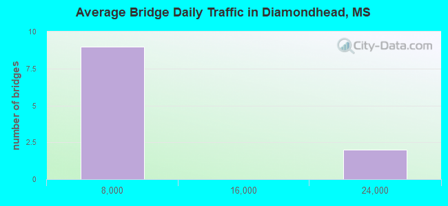
- 74,600Total average daily traffic
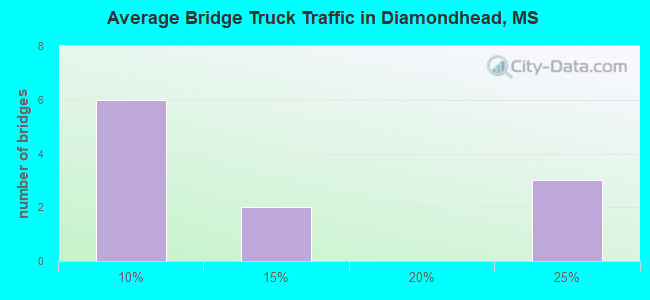
- 8,513Total average daily truck traffic
- National Bridge Inventory (NBI) Registered Bridges for Diamondhead
- No street view available for this location
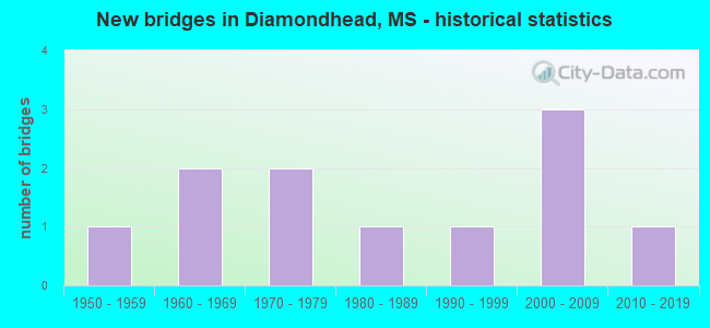
- New bridges - historical statistics
- 11950-1959
- 21960-1969
- 21970-1979
- 11980-1989
- 11990-1999
- 32000-2009
- 12010-2019
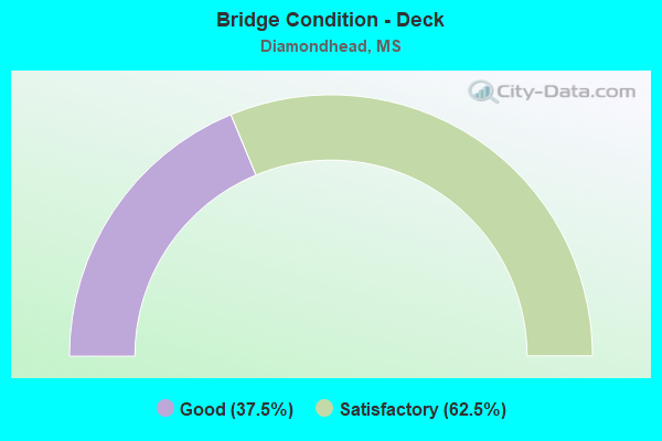
- Bridge Condition - Deck
- 37.5%Good
- 62.5%Satisfactory
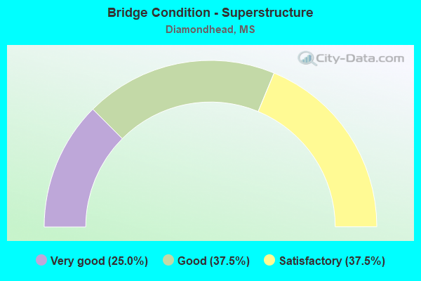
- Bridge Condition - Superstructure
- 25.0%Very good
- 37.5%Good
- 37.5%Satisfactory

- Bridge Condition - Substructure
- 25.0%Very good
- 25.0%Good
- 25.0%Satisfactory
- 25.0%Fair
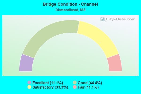
- Bridge Condition - Channel
- 11.1%Excellent
- 44.4%Good
- 33.3%Satisfactory
- 11.1%Fair
Find on map >> Show street view
Structure Number: SA2300000000029, Location: SEC 24 T 7S R14W B (Lat: 30.424750, Lng: -89.357556), Route carried "on" structure: County highway 104, Year Built: 1978, Status: Open, Structure Length: 1.04m (3.41ft), Average Daily Traffic: 5,300 (year 2020), Truck Traffic: 20%, Average Future Daily Traffic: 7,950 (year 2040), Design Load: HS 20, Features Intersected: DRAIN, Facility Carried by Structure: KILN-DELISLE ROAD
Minimum Vertical Clearance: 30+ m (98+ ft), Kilometerpoint: 8.368, Lanes on structure: 2, Owner: County Highway Agency, Approaching Roadway Width: 7.0m (23.0ft), Material/Design: Concrete, Design/Construction: Culvert, Number Of Spans In Main Unit: 2, Length of Maximum Span: 4.9m (16.1ft)
Condition: Channel: Good, Culverts: Good, Operating Rating: 46.1 metric tons, Method Used To Determine Operating Rating: Load Factor (LF), Inventory Rating: 27.8 metric tons, Method Used To Determine Inventory Rating: Load Factor (LF), Structural Evaluation: Equal to present minimum criteria, Waterway Adequacy: Better than present minimum criteria, Approach Roadway Alignment: Equal to present minimum criteria, Designated Inspection Frequency: Every 24 months, Inspection Date: December 2020
Find on map >> Show street view
Structure Number: SA230000000003, Location: SEC 24 T 7S R14W B (Lat: 30.419611, Lng: -89.345028), Route carried "on" structure: County highway 104, Year Built: 1978, Status: Open, Structure Length: 4.88m (16.01ft), Average Daily Traffic: 5,300 (year 2020), Truck Traffic: 20%, Average Future Daily Traffic: 7,950 (year 2040), Design Load: HS 20, Features Intersected: ROTTEN BAYOU, Facility Carried by Structure: KILN-DELISLE ROAD
Minimum Vertical Clearance: 30+ m (98+ ft), Kilometerpoint: 9.816, Lanes on structure: 2, Owner: County Highway Agency, Approaching Roadway Width: 7.3m (24.0ft), Material/Design: Prestressed concrete, Design/Construction: Stringer/Multi-beam, Number Of Spans In Main Unit: 3, Length of Maximum Span: 24.4m (80.1ft), Curb or Sidewalk Widths: Left: 0.4m (1.3ft), Right: 0.4m (1.3ft), Curb-To-Curb Width: 8.5m (27.9ft), Out-to-Out Width: 9.3m (30.5ft)
Condition: Deck: Good, Superstructure: Very good, Substructure: Very good, Channel: Satisfactory, Operating Rating: 61.8 metric tons, Method Used To Determine Operating Rating: Load Factor (LF), Inventory Rating: 36.3 metric tons, Method Used To Determine Inventory Rating: Load Factor (LF), Structural Evaluation: Equal to present desirable criteria, Deck Geometry: High priority of replacement, Waterway Adequacy: Better than present minimum criteria, Approach Roadway Alignment: Equal to present desirable criteria, Length Of Structure Improvement: 6.11m (20.05ft), Designated Inspection Frequency: Every 24 months, Inspection Date: December 2020, Bridge Improvement Cost: $364,000, Roadway Improvement Cost: $36,000, Total Project Cost: $448,000 ( Estimate for 2020), Deck Structure Type: Concrete Cast-file-Place, Wearing Surface/Protective System: Wearing Surface: Monolithic Concrete
Find on map >> Show street view
Structure Number: SA230000000A031, Location: SEC 25 T 7S R14W B (Lat: 30.409417, Lng: -89.344389), Route carried "on" structure: County highway 1292, Year Built: 2016, Status: Open, Structure Length: 2.82m (9.25ft), Average Daily Traffic: 3,000 (year 2020), Truck Traffic: 20%, Average Future Daily Traffic: 4,500 (year 2040), Design Load: HL 93, Features Intersected: MILL CREEK, Facility Carried by Structure: KAPALAMA ROAD
Minimum Vertical Clearance: 30+ m (98+ ft), Kilometerpoint: 1.126, Lanes on structure: 2, Owner: County Highway Agency, Approaching Roadway Width: 6.4m (21.0ft), Material/Design: Concrete, Design/Construction: Channel Beam, Number Of Spans In Main Unit: 3, Length of Maximum Span: 9.4m (30.8ft), Curb or Sidewalk Widths: Left: 0.5m (1.6ft), Right: 0.5m (1.6ft), Curb-To-Curb Width: 8.5m (27.9ft), Out-to-Out Width: 9.5m (31.2ft)
Condition: Deck: Good, Superstructure: Very good, Substructure: Good, Channel: Satisfactory, Operating Rating: 43.7 metric tons, Method Used To Determine Operating Rating: Load and Resistance Factor Rating (LRFR) rating reported by rating factor(RF) method using HL-93 loadings, Inventory Rating: 33.7 metric tons, Method Used To Determine Inventory Rating: Load and Resistance Factor Rating (LRFR) rating reported by rating factor(RF) method using HL-93 loadings, Structural Evaluation: Better than present minimum criteria, Deck Geometry: Meets minimum limits, Waterway Adequacy: Equal to present desirable criteria, Approach Roadway Alignment: Equal to present desirable criteria, Designated Inspection Frequency: Every 24 months, Inspection Date: December 2020, Deck Structure Type: Concrete Precast Panels, Wearing Surface/Protective System: Wearing Surface: Monolithic Concrete
Find on map >> Show street view
Structure Number: SA2400000000129, Location: SEC 7 T 7S R13W B (Lat: 30.447222, Lng: -89.339444), Route carried "on" structure: County highway 3263, Year Built: 2000, Status: Open, Structure Length: 2.85m (9.35ft), Average Daily Traffic: 2,000 (year 2011), Truck Traffic: 8%, Average Future Daily Traffic: 3,000 (year 2032), Design Load: HS 20, Features Intersected: LASALLE BAYOU BRANCH, Facility Carried by Structure: EDWIN LADNER ROAD
Minimum Vertical Clearance: 30+ m (98+ ft), Kilometerpoint: 3.218, Lanes on structure: 2, Owner: County Highway Agency, Approaching Roadway Width: 10.4m (34.1ft), Material/Design: Concrete, Design/Construction: Channel Beam, Number Of Spans In Main Unit: 3, Length of Maximum Span: 9.5m (31.2ft), Curb-To-Curb Width: 8.5m (27.9ft), Out-to-Out Width: 9.4m (30.8ft)
Condition: Deck: Satisfactory, Superstructure: Good, Substructure: Good, Channel: Good, Operating Rating: 63.1 metric tons, Method Used To Determine Operating Rating: Load Factor (LF), Inventory Rating: 37.9 metric tons, Method Used To Determine Inventory Rating: Load Factor (LF), Structural Evaluation: Better than present minimum criteria, Deck Geometry: Somewhat better than minimum adequacy, Waterway Adequacy: Better than present minimum criteria, Approach Roadway Alignment: Equal to present minimum criteria, Designated Inspection Frequency: Every 24 months, Inspection Date: March 2020, Deck Structure Type: Concrete Precast Panels, Wearing Surface/Protective System: Wearing Surface: Monolithic Concrete
Find on map >> Show street view
Structure Number: SA2400000000132, Location: SEC 17 T 7S R13W B (Lat: 30.435833, Lng: -89.316111), Route carried "on" structure: County highway 268, Year Built: 2000, Status: Open, Structure Length: 2.85m (9.35ft), Average Daily Traffic: 600 (year 2011), Truck Traffic: 8%, Average Future Daily Traffic: 900 (year 2032), Design Load: HS 20, Features Intersected: ROTTEN BAYOU BRANCH, Facility Carried by Structure: 16TH SECTION ROAD
Minimum Vertical Clearance: 30+ m (98+ ft), Kilometerpoint: 1.609, Lanes on structure: 2, Owner: County Highway Agency, Approaching Roadway Width: 12.2m (40.0ft), Material/Design: Concrete, Design/Construction: Channel Beam, Number Of Spans In Main Unit: 3, Length of Maximum Span: 9.5m (31.2ft), Curb or Sidewalk Widths: Left: 0.2m (0.7ft), Right: 0.2m (0.7ft), Curb-To-Curb Width: 8.7m (28.5ft), Out-to-Out Width: 9.5m (31.2ft)
Condition: Deck: Good, Superstructure: Good, Substructure: Very good, Channel: Excellent, Operating Rating: 63.1 metric tons, Method Used To Determine Operating Rating: Load Factor (LF), Inventory Rating: 37.9 metric tons, Method Used To Determine Inventory Rating: Load Factor (LF), Structural Evaluation: Better than present minimum criteria, Deck Geometry: Somewhat better than minimum adequacy, Waterway Adequacy: Equal to present desirable criteria, Approach Roadway Alignment: Equal to present desirable criteria, Designated Inspection Frequency: Every 24 months, Inspection Date: March 2020, Deck Structure Type: Concrete Precast Panels, Wearing Surface/Protective System: Wearing Surface: Monolithic Concrete
Find on map >> Show street view
Structure Number: SA2400000000133, Location: SEC 19 T 7S R13W B (Lat: 30.421389, Lng: -89.340000), Route carried "on" structure: County highway 3263, Year Built: 2003, Status: Open, Structure Length: 2.85m (9.35ft), Average Daily Traffic: 2,000 (year 2011), Truck Traffic: 8%, Average Future Daily Traffic: 3,000 (year 2032), Design Load: HS 20, Features Intersected: ROTTEN BAYOU, Facility Carried by Structure: EDWIN LADNER ROAD
Minimum Vertical Clearance: 30+ m (98+ ft), Kilometerpoint: 0.482, Lanes on structure: 2, Owner: County Highway Agency, Approaching Roadway Width: 10.7m (35.1ft), Material/Design: Concrete, Design/Construction: Channel Beam, Number Of Spans In Main Unit: 3, Length of Maximum Span: 9.5m (31.2ft), Curb or Sidewalk Widths: Left: 0.5m (1.6ft), Right: 0.5m (1.6ft), Curb-To-Curb Width: 8.5m (27.9ft), Out-to-Out Width: 9.5m (31.2ft)
Condition: Deck: Satisfactory, Superstructure: Good, Substructure: Satisfactory, Channel: Good, Operating Rating: 63.1 metric tons, Method Used To Determine Operating Rating: Load Factor (LF), Inventory Rating: 37.9 metric tons, Method Used To Determine Inventory Rating: Load Factor (LF), Structural Evaluation: Equal to present minimum criteria, Deck Geometry: Somewhat better than minimum adequacy, Waterway Adequacy: Superior to present desirable criteria, Approach Roadway Alignment: Equal to present minimum criteria, Designated Inspection Frequency: Every 24 months, Inspection Date: Febuary 2020, Deck Structure Type: Concrete Precast Panels, Wearing Surface/Protective System: Wearing Surface: Monolithic Concrete
Find on map >> Show street view
Structure Number: SA2400000000134, Location: SEC 19 T 7S R13W (Lat: 30.416622, Lng: -89.324203), Route carried "on" structure: County highway 3269, Year Built: 1984, Status: Open, Structure Length: 1.16m (3.81ft), Average Daily Traffic: 900 (year 2019), Truck Traffic: 5%, Average Future Daily Traffic: 990 (year 2039), Design Load: H 15, Features Intersected: DELISLE BRANCH, Facility Carried by Structure: CLEO SMITH ROAD
Minimum Vertical Clearance: 30+ m (98+ ft), Kilometerpoint: 1.126, Lanes on structure: 2, Owner: County Highway Agency, Approaching Roadway Width: 8.5m (27.9ft), Material/Design: Concrete, Design/Construction: Channel Beam, Number Of Spans In Main Unit: 2, Length of Maximum Span: 5.8m (19.0ft), Curb or Sidewalk Widths: Left: 0.2m (0.7ft), Right: 0.2m (0.7ft), Curb-To-Curb Width: 7.1m (23.3ft), Out-to-Out Width: 7.6m (24.9ft)
Condition: Deck: Satisfactory, Superstructure: Satisfactory, Substructure: Fair, Channel: Fair, Operating Rating: 49.8 metric tons, Method Used To Determine Operating Rating: Load Factor (LF), Inventory Rating: 29.8 metric tons, Method Used To Determine Inventory Rating: Load Factor (LF), Structural Evaluation: Somewhat better than minimum adequacy, Deck Geometry: Meets minimum limits, Waterway Adequacy: Better than present minimum criteria, Approach Roadway Alignment: Equal to present minimum criteria, Length Of Structure Improvement: 1.16m (3.81ft), Designated Inspection Frequency: Every 24 months, Inspection Date: December 2019, Bridge Improvement Cost: $3,000, Roadway Improvement Cost: $1,000, Total Project Cost: $4,000, Deck Structure Type: Concrete Precast Panels, Wearing Surface/Protective System: Wearing Surface: Monolithic Concrete
Find on map >> Show street view
Structure Number: SA2400000000135, Location: SEC 29 T 7S R13W B (Lat: 30.400914, Lng: -89.317864), Route carried "on" structure: County highway 104, Year Built: 1950, Status: Open, Structure Length: 2.10m (6.89ft), Average Daily Traffic: 6,500 (year 2020), Truck Traffic: 8%, Average Future Daily Traffic: 7,150 (year 2040), Design Load: H 15, Features Intersected: MILL CREEK
Minimum Vertical Clearance: 30+ m (98+ ft), Kilometerpoint: 13.035, Lanes on structure: 2, Owner: County Highway Agency, Approaching Roadway Width: 6.4m (21.0ft), Material/Design: Concrete, Design/Construction: Channel Beam, Number Of Spans In Main Unit: 3, Length of Maximum Span: 9.4m (30.8ft), Curb or Sidewalk Widths: Left: 0.2m (0.7ft), Right: 0.2m (0.7ft), Curb-To-Curb Width: 8.2m (26.9ft), Out-to-Out Width: 8.6m (28.2ft)
Condition: Deck: Satisfactory, Superstructure: Satisfactory, Substructure: Fair, Channel: Satisfactory, Operating Rating: 48.6 metric tons, Method Used To Determine Operating Rating: Load Factor (LF) rating reported by rating factor (RF) method using MS18 loading, Inventory Rating: 29.2 metric tons, Method Used To Determine Inventory Rating: Load Factor (LF) rating reported by rating factor (RF) method using MS18 loading, Structural Evaluation: Somewhat better than minimum adequacy, Deck Geometry: High priority of replacement, Waterway Adequacy: Equal to present desirable criteria, Approach Roadway Alignment: Equal to present desirable criteria, Length Of Structure Improvement: 2.10m (6.89ft), Designated Inspection Frequency: Every 24 months, Inspection Date: December 2020, Bridge Improvement Cost: $2,000, Roadway Improvement Cost: $1,000, Total Project Cost: $3,000, Deck Structure Type: Concrete Precast Panels, Wearing Surface/Protective System: Wearing Surface: Monolithic Concrete
Find on map >> Show street view
Structure Number: SA2400000000136, Location: SEC 30 T 7S R13W B (Lat: 30.409444, Lng: -89.329167), Route carried "on" structure: County highway 104, Year Built: 1993, Status: Open, Structure Length: 2.32m (7.61ft), Average Daily Traffic: 2,000 (year 2011), Truck Traffic: 8%, Average Future Daily Traffic: 3,000 (year 2032), Design Load: H 15, Features Intersected: MILL CREEK BRANCH
Minimum Vertical Clearance: 30+ m (98+ ft), Kilometerpoint: 15.127, Lanes on structure: 2, Owner: County Highway Agency, Approaching Roadway Width: 9.1m (29.9ft), Material/Design: Concrete, Design/Construction: Channel Beam, Number Of Spans In Main Unit: 4, Length of Maximum Span: 5.8m (19.0ft), Curb-To-Curb Width: 8.1m (26.6ft), Out-to-Out Width: 8.5m (27.9ft)
Condition: Deck: Satisfactory, Superstructure: Satisfactory, Substructure: Satisfactory, Channel: Good, Operating Rating: 90.2 metric tons, Method Used To Determine Operating Rating: Load Factor (LF), Inventory Rating: 53.9 metric tons, Method Used To Determine Inventory Rating: Load Factor (LF), Structural Evaluation: Equal to present minimum criteria, Deck Geometry: Meets minimum limits, Waterway Adequacy: Equal to present desirable criteria, Approach Roadway Alignment: Better than present minimum criteria, Length Of Structure Improvement: 2.32m (7.61ft), Designated Inspection Frequency: Every 24 months, Inspection Date: Febuary 2020, Bridge Improvement Cost: $2,000, Roadway Improvement Cost: $1,000, Total Project Cost: $3,000, Deck Structure Type: Concrete Precast Panels, Wearing Surface/Protective System: Wearing Surface: Monolithic Concrete
Find on map >> Show street view
Structure Number: 41000100230175, Location: 3.0 MI E SR 43 (Lat: 30.373064, Lng: -89.377167), Route carried "under" structure: Interstate 10, Year Built: 1968, Structure Length: 0. m, Average Daily Traffic: 23,500 (year 2017), Truck Traffic: 10%, Features Intersected: I 10, Facility Carried by Structure: DIAMONDHEAD DR
Minimum Vertical Clearance: 5.18m (16.99ft), Kilometerpoint: 0.898, Lanes on structure: 2, Lanes under structure: 4, Material/Design: Prestressed concrete continuous, Design/Construction: Stringer/Multi-beam, Length of Maximum Span: 35.1m (115.2ft)
Find on map >> Show street view
Structure Number: 41000100230175, Location: 3.0 MI E SR 43 (Lat: 30.373064, Lng: -89.377167), Route carried "under" structure: Interstate 10, Year Built: 1968, Structure Length: 0. m, Average Daily Traffic: 23,500 (year 2017), Truck Traffic: 10%, Features Intersected: I 10, Facility Carried by Structure: DIAMONDHEAD DR
Minimum Vertical Clearance: 5.12m (16.80ft), Kilometerpoint: 0.898, Lanes on structure: 2, Lanes under structure: 4, Material/Design: Prestressed concrete continuous, Design/Construction: Stringer/Multi-beam, Length of Maximum Span: 35.1m (115.2ft)