Bridge Statistics for Dewey-Humboldt, Arizona (AZ)
Condition, Traffic, Stress, Structural Evaluation, Project Costs
- National Bridge Inventory (NBI) Statistics
- 13Number of bridges
- 138ft / 41.7mTotal length
- $7,000Total costs
- 135,872Total average daily traffic
- 13,867Total average daily truck traffic
- 136,002Total future (year 2037) average daily traffic
- National Bridge Inventory (NBI) Registered Bridges for Dewey-Humboldt
- No street view available for this location
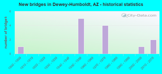
- New bridges - historical statistics
- 11900-1909
- 51950-1959
- 41970-1979
- 12000-2009
- 22010-2019

- Reconstructed bridges - Historical Statistics
- 41980-1989
- 21990-1999


- Bridge Condition - Deck
- 60.0%Good
- 40.0%Satisfactory

- Bridge Condition - Superstructure
- 60.0%Very good
- 20.0%Good
- 20.0%Satisfactory

- Bridge Condition - Substructure
- 40.0%Very good
- 60.0%Good

- Bridge Condition - Channel
- 7.7%Very good
- 69.2%Good
- 15.4%Satisfactory
- 7.7%Fair

- Bridge Condition - Culverts
- 87.5%Good
- 12.5%Satisfactory
Find on map >> Show street view
Structure Number: 2897, Location: 0.25 mi E Jct SR 69 (Lat: 34.529800, Lng: -112.237900), Route carried "on" structure: State highway 169, Year Built: 2010, Status: Open, Structure Length: 7.68m (25.20ft), Average Daily Traffic: 7,947 (year 2018), Truck Traffic: 6%, Average Future Daily Traffic: 7,957 (year 2040), Design Load: HS 25 or greater, Features Intersected: Agua Fria River
Minimum Vertical Clearance: 9.14m (29.99ft), Kilometerpoint: 0.402, Lanes on structure: 2, Owner: State Highway Agency, Approaching Roadway Width: 18.0m (59.1ft), Skew: 1 degrees, Material/Design: Prestressed concrete continuous, Design/Construction: Stringer/Multi-beam, Number Of Spans In Main Unit: 2, Length of Maximum Span: 37.5m (123.0ft), Curb or Sidewalk Widths: Left: 1.8m (5.9ft), Right: 1.8m (5.9ft), Curb-To-Curb Width: 20.7m (67.9ft), Out-to-Out Width: 25.0m (82.0ft)
Condition: Deck: Good, Superstructure: Very good, Substructure: Very good, Channel: Satisfactory, Operating Rating: 82.6 metric tons, Method Used To Determine Operating Rating: Load Factor (LF), Inventory Rating: 43.5 metric tons, Method Used To Determine Inventory Rating: Load Factor (LF), Structural Evaluation: Equal to present desirable criteria, Deck Geometry: Superior to present desirable criteria, Waterway Adequacy: Equal to present desirable criteria, Approach Roadway Alignment: Equal to present desirable criteria, Designated Inspection Frequency: Every 24 months, Inspection Date: July 2020, Deck Structure Type: Concrete Cast-file-Place, Wearing Surface/Protective System: Wearing Surface: Monolithic Concrete
Find on map >> Show street view
Structure Number: 4269, Location: 15.2 mi NW Jct I 17 (Lat: 34.501900, Lng: -112.244900), Route carried "on" structure: State highway 69, Year Built: 1954, Year Reconstructed: 1995, Status: Open, Structure Length: 1.37m (4.49ft), Average Daily Traffic: 9,077 (year 2020), Truck Traffic: 10%, Average Future Daily Traffic: 9,087 (year 2040), Design Load: HS 20, Features Intersected: Chaparral Wash
Minimum Vertical Clearance: 30+ m (98+ ft), Kilometerpoint: 449.270, Lanes on structure: 4, Owner: State Highway Agency, Approaching Roadway Width: 23.2m (76.1ft), Skew: 29 degrees, Material/Design: Concrete continuous, Design/Construction: Culvert, Number Of Spans In Main Unit: 4, Length of Maximum Span: 3.0m (9.8ft)
Condition: Channel: Good, Culverts: Good, Operating Rating: 89.8 metric tons, Method Used To Determine Operating Rating: Load Factor (LF), Inventory Rating: 65.3 metric tons, Method Used To Determine Inventory Rating: Load Factor (LF), Structural Evaluation: Better than present minimum criteria, Waterway Adequacy: Better than present minimum criteria, Approach Roadway Alignment: Equal to present desirable criteria, Length Of Structure Improvement: 2.07m (6.79ft), Designated Inspection Frequency: Every 48 months, Inspection Date: July 2021, Roadway Improvement Cost: $1,000, Total Project Cost: $2,000 ( Estimate for 2017)
Find on map >> Show street view
Structure Number: 427, Location: 17.1 mi W Jct I 17 (Lat: 34.520700, Lng: -112.238500), Route carried "on" structure: State highway 69, Year Built: 1954, Year Reconstructed: 1994, Status: Open, Structure Length: 0.98m (3.22ft), Average Daily Traffic: 15,855 (year 2020), Truck Traffic: 13%, Average Future Daily Traffic: 15,865 (year 2040), Design Load: HS 20, Features Intersected: Green Gulch
Minimum Vertical Clearance: 30+ m (98+ ft), Kilometerpoint: 450.660, Lanes on structure: 5, Owner: State Highway Agency, Approaching Roadway Width: 29.6m (97.1ft), Skew: 20 degrees, Material/Design: Concrete continuous, Design/Construction: Culvert, Number Of Spans In Main Unit: 3, Length of Maximum Span: 3.0m (9.8ft)
Condition: Channel: Good, Culverts: Satisfactory, Operating Rating: 89.8 metric tons, Method Used To Determine Operating Rating: Load Factor (LF), Inventory Rating: 89.8 metric tons, Method Used To Determine Inventory Rating: Load Factor (LF), Structural Evaluation: Equal to present minimum criteria, Waterway Adequacy: Better than present minimum criteria, Approach Roadway Alignment: Better than present minimum criteria, Length Of Structure Improvement: 1.74m (5.71ft), Designated Inspection Frequency: Every 48 months, Inspection Date: July 2021, Roadway Improvement Cost: $1,000, Total Project Cost: $1,000 ( Estimate for 2014)
Find on map >> Show street view
Structure Number: 4271, Location: 18.1 mi W Jct I 17 (Lat: 34.528500, Lng: -112.241600), Route carried "on" structure: State highway 69, Year Built: 1954, Year Reconstructed: 1992, Status: Open, Structure Length: 1.31m (4.30ft), Average Daily Traffic: 17,846 (year 2020), Truck Traffic: 10%, Average Future Daily Traffic: 17,856 (year 2040), Design Load: HS 20, Features Intersected: Wash
Minimum Vertical Clearance: 30+ m (98+ ft), Kilometerpoint: 452.360, Lanes on structure: 5, Owner: State Highway Agency, Approaching Roadway Width: 23.2m (76.1ft), Material/Design: Concrete continuous, Design/Construction: Culvert, Number Of Spans In Main Unit: 4, Length of Maximum Span: 3.0m (9.8ft)
Condition: Channel: Good, Culverts: Good, Operating Rating: 89.8 metric tons, Method Used To Determine Operating Rating: Load Factor (LF), Inventory Rating: 74.4 metric tons, Method Used To Determine Inventory Rating: Load Factor (LF), Structural Evaluation: Better than present minimum criteria, Waterway Adequacy: Better than present minimum criteria, Approach Roadway Alignment: Equal to present desirable criteria, Length Of Structure Improvement: 2.07m (6.79ft), Designated Inspection Frequency: Every 48 months, Inspection Date: July 2021, Total Project Cost: $1,000 ( Estimate for 2017)
Find on map >> Show street view
Structure Number: 4272, Location: 19.1 mi W Jct I 17 (Lat: 34.547222, Lng: -112.258333), Route carried "on" structure: State highway 69, Year Built: 1954, Year Reconstructed: 1989, Status: Open, Structure Length: 1.98m (6.50ft), Average Daily Traffic: 25,531 (year 2015), Truck Traffic: 10%, Average Future Daily Traffic: 25,541 (year 2037), Design Load: HS 20, Features Intersected: Wash
Minimum Vertical Clearance: 30+ m (98+ ft), Kilometerpoint: 453.960, Lanes on structure: 5, Owner: State Highway Agency, Approaching Roadway Width: 23.2m (76.1ft), Material/Design: Concrete continuous, Design/Construction: Culvert, Number Of Spans In Main Unit: 6, Length of Maximum Span: 3.0m (9.8ft)
Condition: Channel: Good, Culverts: Good, Operating Rating: 50.8 metric tons, Method Used To Determine Operating Rating: Load Factor (LF), Inventory Rating: 29.9 metric tons, Method Used To Determine Inventory Rating: Load Factor (LF), Structural Evaluation: Better than present minimum criteria, Waterway Adequacy: Better than present minimum criteria, Approach Roadway Alignment: Equal to present desirable criteria, Length Of Structure Improvement: 2.74m (8.99ft), Designated Inspection Frequency: Every 48 months, Inspection Date: October 2020, Total Project Cost: $1,000 ( Estimate for 2017)
Find on map >> Show street view
Structure Number: 4273, Location: 19.6 mi NW Jct I 17 (Lat: 34.549000, Lng: -112.250900), Route carried "on" structure: State highway 69, Year Built: 1954, Year Reconstructed: 2004, Status: Open, Structure Length: 1.98m (6.50ft), Average Daily Traffic: 36,515 (year 2020), Truck Traffic: 10%, Average Future Daily Traffic: 36,525 (year 2040), Design Load: HS 20, Features Intersected: Clipper Wash
Minimum Vertical Clearance: 30+ m (98+ ft), Kilometerpoint: 454.780, Lanes on structure: 7, Owner: State Highway Agency, Approaching Roadway Width: 23.2m (76.1ft), Skew: 9 degrees, Material/Design: Concrete continuous, Design/Construction: Culvert, Number Of Spans In Main Unit: 6, Length of Maximum Span: 3.0m (9.8ft)
Condition: Channel: Good, Culverts: Good, Operating Rating: 89.8 metric tons, Method Used To Determine Operating Rating: Load Factor (LF), Inventory Rating: 89.8 metric tons, Method Used To Determine Inventory Rating: Load Factor (LF), Structural Evaluation: Better than present minimum criteria, Waterway Adequacy: Better than present minimum criteria, Approach Roadway Alignment: Equal to present desirable criteria, Length Of Structure Improvement: 2.77m (9.09ft), Designated Inspection Frequency: Every 48 months, Inspection Date: July 2021, Total Project Cost: $1,000
Find on map >> Show street view
Structure Number: 635, Location: 0.9 mi E Jct SR 69 (Lat: 34.529300, Lng: -112.227300), Route carried "on" structure: State highway 169, Year Built: 1971, Year Reconstructed: 1988, Status: Open, Structure Length: 1.34m (4.40ft), Average Daily Traffic: 7,947 (year 2018), Truck Traffic: 6%, Average Future Daily Traffic: 7,957 (year 2040), Design Load: HS 20, Features Intersected: Texas Gulch
Minimum Vertical Clearance: 30+ m (98+ ft), Kilometerpoint: 1.368, Lanes on structure: 2, Owner: State Highway Agency, Approaching Roadway Width: 10.4m (34.1ft), Skew: 1 degrees, Material/Design: Concrete continuous, Design/Construction: Culvert, Number Of Spans In Main Unit: 4, Length of Maximum Span: 3.0m (9.8ft)
Condition: Channel: Good, Culverts: Good, Operating Rating: 89.8 metric tons, Method Used To Determine Operating Rating: Load Factor (LF), Inventory Rating: 71.7 metric tons, Method Used To Determine Inventory Rating: Load Factor (LF), Structural Evaluation: Better than present minimum criteria, Waterway Adequacy: Equal to present desirable criteria, Approach Roadway Alignment: Equal to present desirable criteria, Designated Inspection Frequency: Every 48 months, Inspection Date: July 2020
Find on map >> Show street view
Structure Number: 6616, Location: 5.0 mi E Jct SR 69 (Lat: 34.546500, Lng: -112.160400), Route carried "on" structure: State highway 169, Year Built: 1977, Status: Open, Structure Length: 2.10m (6.89ft), Average Daily Traffic: 5,844 (year 2018), Truck Traffic: 11%, Average Future Daily Traffic: 5,854 (year 2040), Design Load: HS 20, Features Intersected: Yarber Wash
Minimum Vertical Clearance: 30+ m (98+ ft), Kilometerpoint: 7.934, Lanes on structure: 2, Owner: State Highway Agency, Approaching Roadway Width: 18.6m (61.0ft), Skew: 2 degrees, Material/Design: Concrete continuous, Design/Construction: Culvert, Number Of Spans In Main Unit: 6, Length of Maximum Span: 3.0m (9.8ft)
Condition: Channel: Very good, Culverts: Good, Operating Rating: 89.8 metric tons, Method Used To Determine Operating Rating: Load Factor (LF), Inventory Rating: 89.8 metric tons, Method Used To Determine Inventory Rating: Load Factor (LF), Structural Evaluation: Better than present minimum criteria, Waterway Adequacy: Equal to present desirable criteria, Approach Roadway Alignment: Equal to present desirable criteria, Designated Inspection Frequency: Every 48 months, Inspection Date: July 2020
Find on map >> Show street view
Structure Number: 8248, Location: 1.0 mi SE Jct SR 169 (Lat: 34.513400, Lng: -112.233500), Route carried "on" structure: City street , Year Built: 1900, Status: Open, Structure Length: 0.70m (2.30ft), Average Daily Traffic: 330 (year 2017), Truck Traffic: 5%, Average Future Daily Traffic: 340 (year 2037), Design Load: H 15, Features Intersected: Green Gulch, Facility Carried by Structure: Old Blk Canyon Hwy
Minimum Vertical Clearance: 30+ m (98+ ft), Kilometerpoint: 0.000, Lanes on structure: 2, Owner: Town or Township Highway Agency, Approaching Roadway Width: 6.1m (20.0ft), Material/Design: Concrete, Design/Construction: Slab, Number Of Spans In Main Unit: 1, Length of Maximum Span: 6.1m (20.0ft), Curb or Sidewalk Widths: Left: 0.4m (1.3ft), Right: 0.4m (1.3ft), Curb-To-Curb Width: 6.2m (20.3ft), Out-to-Out Width: 6.9m (22.6ft)
Condition: Deck: Satisfactory, Superstructure: Satisfactory, Substructure: Good, Channel: Good, Operating Rating: 36.3 metric tons, Method Used To Determine Operating Rating: Field evaluation and documented engineering judgment, Inventory Rating: 21.8 metric tons, Method Used To Determine Inventory Rating: Field evaluation and documented engineering judgment, Structural Evaluation: Equal to present minimum criteria, Deck Geometry: Meets minimum limits, Waterway Adequacy: Better than present minimum criteria, Approach Roadway Alignment: Equal to present minimum criteria, Length Of Structure Improvement: 1.43m (4.69ft), Designated Inspection Frequency: Every 24 months, Inspection Date: July 2021, Total Project Cost: $1,000 ( Estimate for 2021), Deck Structure Type: Concrete Cast-file-Place, Wearing Surface/Protective System: Wearing Surface: Bituminous
Find on map >> Show street view
Structure Number: 10773, Location: 0.75 mi S Sarah Jane Ln (Lat: 34.564028, Lng: -112.259333), Route carried "on" structure: County highway , Year Built: 1973, Status: Open, Structure Length: 1.16m (3.81ft), Average Daily Traffic: 110 (year 2019), Truck Traffic: 1%, Average Future Daily Traffic: 120 (year 2039), Design Load: HS 20, Features Intersected: Lynx Creek, Facility Carried by Structure: Orchard Ct
Minimum Vertical Clearance: 30+ m (98+ ft), Kilometerpoint: 0.000, Lanes on structure: 2, Owner: County Highway Agency, Approaching Roadway Width: 9.4m (30.8ft), Skew: 1 degrees, Material/Design: Steel, Design/Construction: Culvert, Number Of Spans In Main Unit: 6, Length of Maximum Span: 1.4m (4.6ft), Curb-To-Curb Width: 9.3m (30.5ft), Out-to-Out Width: 9.4m (30.8ft)
Condition: Channel: Fair, Culverts: Good, Operating Rating: 52.6 metric tons, Method Used To Determine Operating Rating: Load Factor (LF), Inventory Rating: 29.9 metric tons, Method Used To Determine Inventory Rating: Load Factor (LF), Structural Evaluation: Better than present minimum criteria, Deck Geometry: Equal to present minimum criteria, Waterway Adequacy: Equal to present minimum criteria, Approach Roadway Alignment: Equal to present minimum criteria, Designated Inspection Frequency: Every 48 months, Inspection Date: August 2019, Deck Structure Type: Concrete Cast-file-Place, Wearing Surface/Protective System: Wearing Surface: Monolithic Concrete
Find on map >> Show street view
Structure Number: 10775, Location: 200 ft S Jct Manzanita Tr (Lat: 34.558500, Lng: -112.279800), Route carried "on" structure: County highway , Year Built: 1973, Status: Open, Structure Length: 2.41m (7.91ft), Average Daily Traffic: 300 (year 2021), Truck Traffic: 5%, Average Future Daily Traffic: 310 (year 2041), Design Load: HS 20, Features Intersected: Clipper Wash, Facility Carried by Structure: Durham Rd
Minimum Vertical Clearance: 30+ m (98+ ft), Kilometerpoint: 0.000, Lanes on structure: 2, Owner: County Highway Agency, Approaching Roadway Width: 9.1m (29.9ft), Material/Design: Prestressed concrete, Design/Construction: Box Beam or Girders - Multiple, Number Of Spans In Main Unit: 2, Length of Maximum Span: 11.9m (39.0ft), Curb-To-Curb Width: 9.1m (29.9ft), Out-to-Out Width: 9.8m (32.2ft)
Condition: Deck: Good, Superstructure: Good, Substructure: Good, Channel: Satisfactory, Operating Rating: 54.4 metric tons, Method Used To Determine Operating Rating: Field evaluation and documented engineering judgment, Inventory Rating: 32.7 metric tons, Method Used To Determine Inventory Rating: Field evaluation and documented engineering judgment, Structural Evaluation: Better than present minimum criteria, Deck Geometry: Equal to present minimum criteria, Waterway Adequacy: Better than present minimum criteria, Approach Roadway Alignment: Equal to present minimum criteria, Designated Inspection Frequency: Every 24 months, Inspection Date: July 2021, Deck Structure Type: Concrete Cast-file-Place, Wearing Surface/Protective System: Wearing Surface: Bituminous
Find on map >> Show street view
Structure Number: 20085, Location: 0.15 mi N Jct SR 69 (Lat: 34.563900, Lng: -112.258100), Route carried "on" structure: Spur State highway 89, Year Built: 2012, Status: Open, Structure Length: 9.17m (30.09ft), Average Daily Traffic: 4,301 (year 2018), Truck Traffic: 15%, Average Future Daily Traffic: 4,311 (year 2039), Design Load: HL 93, Features Intersected: Lynx Creek
Minimum Vertical Clearance: 9.14m (29.99ft), Kilometerpoint: 533.610, Lanes on structure: 2, Owner: State Highway Agency, Approaching Roadway Width: 11.6m (38.1ft), Skew: 2 degrees, Material/Design: Prestressed concrete continuous, Design/Construction: Stringer/Multi-beam, Number Of Spans In Main Unit: 3, Length of Maximum Span: 30.5m (100.1ft), Curb-To-Curb Width: 12.8m (42.0ft), Out-to-Out Width: 13.7m (44.9ft)
Condition: Deck: Good, Superstructure: Very good, Substructure: Very good, Channel: Good, Operating Rating: 77.1 metric tons, Method Used To Determine Operating Rating: Load Factor (LF), Inventory Rating: 44.5 metric tons, Method Used To Determine Inventory Rating: Load Factor (LF), Structural Evaluation: Equal to present desirable criteria, Deck Geometry: Equal to present desirable criteria, Waterway Adequacy: Equal to present desirable criteria, Approach Roadway Alignment: Better than present minimum criteria, Designated Inspection Frequency: Every 24 months, Inspection Date: July 2021, Deck Structure Type: Concrete Cast-file-Place, Wearing Surface/Protective System: Wearing Surface: Monolithic Concrete, Deck Protection: Epoxy Coated Reinforcing
Find on map >> Show street view
Structure Number: 20086, Location: 0.15 mi N Jct SR 69 (Lat: 34.564100, Lng: -112.258300), Route carried "on" structure: Spur State highway 89, Year Built: 2002, Status: Open, Structure Length: 9.48m (31.10ft), Average Daily Traffic: 4,269 (year 2018), Truck Traffic: 15%, Average Future Daily Traffic: 4,279 (year 2039), Design Load: HS 20, Features Intersected: Lynx Creek
Minimum Vertical Clearance: 6.10m (20.01ft), Kilometerpoint: 533.610, Lanes on structure: 2, Owner: State Highway Agency, Approaching Roadway Width: 11.6m (38.1ft), Skew: 2 degrees, Material/Design: Prestressed concrete continuous, Design/Construction: Stringer/Multi-beam, Number Of Spans In Main Unit: 3, Length of Maximum Span: 31.4m (103.0ft), Curb-To-Curb Width: 12.8m (42.0ft), Out-to-Out Width: 13.7m (44.9ft)
Condition: Deck: Satisfactory, Superstructure: Very good, Substructure: Good, Channel: Good, Operating Rating: 76.2 metric tons, Method Used To Determine Operating Rating: Load Factor (LF), Inventory Rating: 39.9 metric tons, Method Used To Determine Inventory Rating: Load Factor (LF), Structural Evaluation: Better than present minimum criteria, Deck Geometry: Equal to present desirable criteria, Waterway Adequacy: Equal to present desirable criteria, Approach Roadway Alignment: Equal to present desirable criteria, Designated Inspection Frequency: Every 24 months, Inspection Date: July 2021, Deck Structure Type: Concrete Cast-file-Place, Wearing Surface/Protective System: Wearing Surface: Monolithic Concrete, Deck Protection: Epoxy Coated Reinforcing