Bridge Statistics for Depew, New York (NY)
Condition, Traffic, Stress, Structural Evaluation, Project Costs
- National Bridge Inventory (NBI) Statistics
- 21Number of bridges
- 92ft / 27.7mTotal length
- $34,260,000Total costs
- 287,272Total average daily traffic
- 4,954Total average daily truck traffic
- National Bridge Inventory (NBI) Registered Bridges for Depew
- No street view available for this location
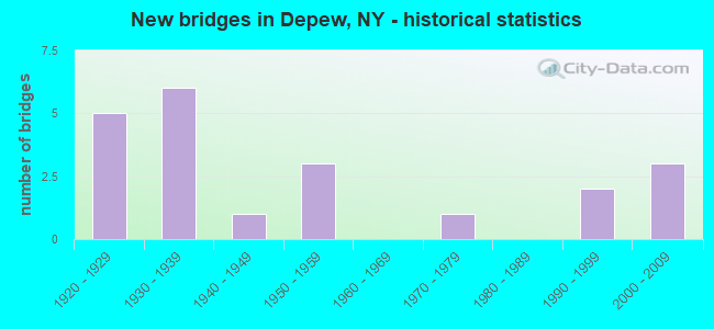
- New bridges - historical statistics
- 51920-1929
- 61930-1939
- 11940-1949
- 31950-1959
- 11970-1979
- 21990-1999
- 32000-2009
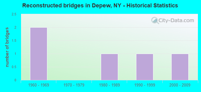
- Reconstructed bridges - Historical Statistics
- 21960-1969
- 01970-1979
- 11980-1989
- 11990-1999
- 12000-2009
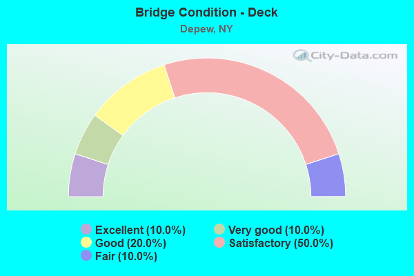
- Bridge Condition - Deck
- 10.0%Excellent
- 10.0%Very good
- 20.0%Good
- 50.0%Satisfactory
- 10.0%Fair
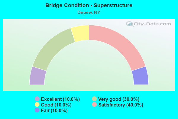
- Bridge Condition - Superstructure
- 10.0%Excellent
- 30.0%Very good
- 10.0%Good
- 40.0%Satisfactory
- 10.0%Fair
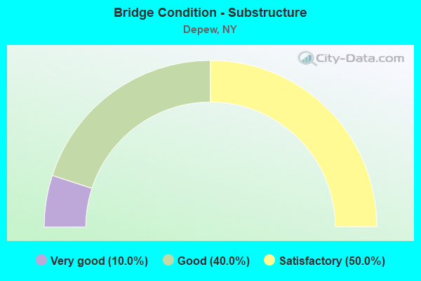
- Bridge Condition - Substructure
- 10.0%Very good
- 40.0%Good
- 50.0%Satisfactory
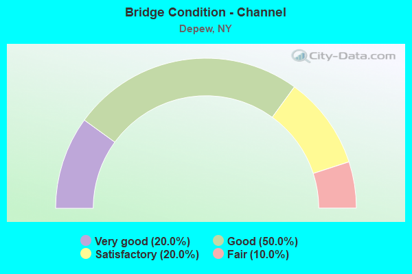
- Bridge Condition - Channel
- 20.0%Very good
- 50.0%Good
- 20.0%Satisfactory
- 10.0%Fair
Find on map >> Show street view
Structure Number: 101556, Location: 2.9 MI N JCT RTS 20 + 354 (Lat: 42.900803, Lng: -78.696983), Route carried "on" structure: US 20, Year Built: 1929, Year Reconstructed: 1998, Status: Open, Structure Length: 4.02m (13.19ft), Average Daily Traffic: 20,830 (year 2020), Truck Traffic: 5%, Average Future Daily Traffic: 20,927 (year 2040), Design Load: HS 25 or greater, Features Intersected: CAYUGA CREEK
Minimum Vertical Clearance: 30+ m (98+ ft), Kilometerpoint: 53.982, Lanes on structure: 4, Base Highway Network: Yes, Owner: State Highway Agency, Approaching Roadway Width: 17.7m (58.1ft), Skew: 22 degrees, Material/Design: Prestressed concrete, Design/Construction: Box Beam or Girders - Multiple, Number Of Spans In Main Unit: 2, Length of Maximum Span: 18.8m (61.7ft), Curb or Sidewalk Widths: Left: 1.5m (4.9ft), Right: 1.5m (4.9ft), Curb-To-Curb Width: 17.7m (58.1ft), Out-to-Out Width: 21.3m (69.9ft)
Condition: Deck: Good, Superstructure: Very good, Substructure: Good, Channel: Very good, Operating Rating: 72.9 metric tons, Method Used To Determine Operating Rating: Load and Resistance Factor Rating (LRFR) rating reported by rating factor(RF) method using HL-93 loadings, Inventory Rating: 55.7 metric tons, Method Used To Determine Inventory Rating: Load and Resistance Factor Rating (LRFR) rating reported by rating factor(RF) method using HL-93 loadings, Structural Evaluation: Better than present minimum criteria, Deck Geometry: Somewhat better than minimum adequacy, Waterway Adequacy: Equal to present desirable criteria, Approach Roadway Alignment: Equal to present desirable criteria, Length Of Structure Improvement: 4.02m (13.19ft), Designated Inspection Frequency: Every 24 months, Inspection Date: March 2020, Bridge Improvement Cost: $2,134,000, Roadway Improvement Cost: $1,249,000, Total Project Cost: $3,383,000 ( Estimate for 2021), Wearing Surface/Protective System: Wearing Surface: Monolithic Concrete
Find on map >> Show street view
Structure Number: 101557, Location: 0.6 MI E JCT US20&NY130 (Lat: 42.901442, Lng: -78.685122), Route carried "on" structure: US 20, Year Built: 2002, Status: Open, Structure Length: 3.96m (12.99ft), Average Daily Traffic: 12,882 (year 2018), Truck Traffic: 5%, Average Future Daily Traffic: 12,942 (year 2040), Design Load: HS 25 or greater, Features Intersected: CAYUGA CREEK
Minimum Vertical Clearance: 30+ m (98+ ft), Kilometerpoint: 55.076, Lanes on structure: 4, Base Highway Network: Yes, Owner: State Highway Agency, Approaching Roadway Width: 18.0m (59.1ft), Skew: 21 degrees, Material/Design: Steel, Design/Construction: Stringer/Multi-beam, Number Of Spans In Main Unit: 1, Length of Maximum Span: 38.0m (124.7ft), Curb or Sidewalk Widths: Left: 1.5m (4.9ft), Right: 1.5m (4.9ft), Curb-To-Curb Width: 18.0m (59.1ft), Out-to-Out Width: 22.0m (72.2ft)
Condition: Deck: Fair, Superstructure: Very good, Substructure: Good, Channel: Very good, Inventory Rating: 73.5 metric tons, Method Used To Determine Inventory Rating: Load Factor (LF), Structural Evaluation: Better than present minimum criteria, Deck Geometry: Somewhat better than minimum adequacy, Waterway Adequacy: Equal to present minimum criteria, Approach Roadway Alignment: Equal to present desirable criteria, Length Of Structure Improvement: 3.96m (12.99ft), Designated Inspection Frequency: Every 24 months, Inspection Date: June 2020, Bridge Improvement Cost: $4,960,000, Roadway Improvement Cost: $2,905,000, Total Project Cost: $7,865,000 ( Estimate for 2021), Deck Structure Type: Concrete Cast-file-Place, Wearing Surface/Protective System: Wearing Surface: Monolithic Concrete, Deck Protection: Epoxy Coated Reinforcing
Find on map >> Show street view
Structure Number: 103024, Location: .9 MI N JCT SH 78 & SH130 (Lat: 42.915547, Lng: -78.696903), Route carried "on" structure: State highway 78, Year Built: 1953, Status: Open, Structure Length: 1.01m (3.31ft), Average Daily Traffic: 20,764 (year 2019), Truck Traffic: 5%, Average Future Daily Traffic: 20,861 (year 2040), Features Intersected: SCAJAQUADA CREEK
Minimum Vertical Clearance: 30+ m (98+ ft), Kilometerpoint: 34.706, Lanes on structure: 4, Base Highway Network: Yes, Owner: State Highway Agency, Approaching Roadway Width: 13.4m (44.0ft), Material/Design: Concrete, Design/Construction: Slab, Number Of Spans In Main Unit: 1, Length of Maximum Span: 9.7m (31.8ft), Curb or Sidewalk Widths: Left: 3.7m (12.1ft), Right: 3.7m (12.1ft), Curb-To-Curb Width: 13.4m (44.0ft), Out-to-Out Width: 21.9m (71.9ft)
Condition: Deck: Satisfactory, Superstructure: Good, Substructure: Good, Channel: Good, Operating Rating: 45.0 metric tons, Method Used To Determine Operating Rating: Load and Resistance Factor Rating (LRFR) rating reported by rating factor(RF) method using HL-93 loadings, Inventory Rating: 34.7 metric tons, Method Used To Determine Inventory Rating: Load and Resistance Factor Rating (LRFR) rating reported by rating factor(RF) method using HL-93 loadings, Structural Evaluation: Better than present minimum criteria, Deck Geometry: High priority of replacement, Waterway Adequacy: Equal to present desirable criteria, Approach Roadway Alignment: Somewhat better than minimum adequacy, Length Of Structure Improvement: 1.00m (3.28ft), Designated Inspection Frequency: Every 24 months, Inspection Date: April 2020, Bridge Improvement Cost: $787,000, Roadway Improvement Cost: $461,000, Total Project Cost: $1,248,000 ( Estimate for 2021), Wearing Surface/Protective System: Wearing Surface: Bituminous, Membrane: Other
Find on map >> Show street view
Structure Number: 226031, Location: .9 MI NW OF DEPEW (Lat: 42.914294, Lng: -78.709367), Route carried "on" structure: Other road , Year Built: 1992, Status: Open, Structure Length: 0.73m (2.40ft), Average Daily Traffic: 1,591 (year 2016), Truck Traffic: 2%, Average Future Daily Traffic: 2,227 (year 2036), Design Load: HS 20, Features Intersected: SCAJAQUADA CREEK, Facility Carried by Structure: LEDYARD AVENUE
Minimum Vertical Clearance: 30+ m (98+ ft), Kilometerpoint: 0.483, Lanes on structure: 2, Owner: Town or Township Highway Agency, Approaching Roadway Width: 7.9m (25.9ft), Material/Design: Concrete, Design/Construction: Culvert, Number Of Spans In Main Unit: 1, Length of Maximum Span: 7.0m (23.0ft), Curb or Sidewalk Widths: Left: 2.7m (8.9ft), Right: 2.7m (8.9ft), Curb-To-Curb Width: 7.9m (25.9ft), Out-to-Out Width: 16.3m (53.5ft)
Condition: Channel: Good, Culverts: Satisfactory, Operating Rating: 47.3 metric tons, Method Used To Determine Operating Rating: Load and Resistance Factor Rating (LRFR) rating reported by rating factor(RF) method using HL-93 loadings, Inventory Rating: 36.3 metric tons, Method Used To Determine Inventory Rating: Load and Resistance Factor Rating (LRFR) rating reported by rating factor(RF) method using HL-93 loadings, Structural Evaluation: Equal to present minimum criteria, Deck Geometry: Meets minimum limits, Waterway Adequacy: Somewhat better than minimum adequacy, Approach Roadway Alignment: Equal to present desirable criteria, Length Of Structure Improvement: 0.73m (2.40ft), Designated Inspection Frequency: Every 24 months, Inspection Date: September 2020, Bridge Improvement Cost: $330,000, Roadway Improvement Cost: $193,000, Total Project Cost: $523,000 ( Estimate for 2021)
Find on map >> Show street view
Structure Number: 226396, Location: 0.5 MI NE JCT RTS 78 &130 (Lat: 42.905694, Lng: -78.685183), Route carried "on" structure: Other road , Year Built: 1930, Year Reconstructed: 1986, Status: Open, Structure Length: 1.68m (5.51ft), Average Daily Traffic: 340 (year 2017), Truck Traffic: 2%, Average Future Daily Traffic: 476 (year 2037), Design Load: HS 20, Features Intersected: SANILAC STREET, Facility Carried by Structure: ST. JAMES STREET
Minimum Vertical Clearance: 30+ m (98+ ft), Kilometerpoint: 0.193, Lanes on structure: 2, Lanes under structure: 2, Owner: Town or Township Highway Agency, Approaching Roadway Width: 6.1m (20.0ft), Material/Design: Prestressed concrete, Design/Construction: Box Beam or Girders - Multiple, Number Of Spans In Main Unit: 1, Length of Maximum Span: 15.8m (51.8ft), Curb or Sidewalk Widths: Left: 1.3m (4.3ft), Right: 0.0m, Curb-To-Curb Width: 6.1m (20.0ft), Out-to-Out Width: 8.3m (27.2ft)
Condition: Deck: Satisfactory, Superstructure: Satisfactory, Substructure: Satisfactory, Operating Rating: 88.0 metric tons, Method Used To Determine Operating Rating: Load Factor (LF), Inventory Rating: 44.5 metric tons, Method Used To Determine Inventory Rating: Load Factor (LF), Structural Evaluation: Equal to present minimum criteria, Deck Geometry: Meets minimum limits, Underclear: High priority of corrective action, Approach Roadway Alignment: Equal to present desirable criteria, Length Of Structure Improvement: 1.67m (5.48ft), Designated Inspection Frequency: Every 24 months, Inspection Date: August 2020, Bridge Improvement Cost: $499,000, Roadway Improvement Cost: $292,000, Total Project Cost: $791,000 ( Estimate for 2021), Deck Structure Type: Concrete Cast-file-Place, Wearing Surface/Protective System: Wearing Surface: Integral Concrete, Deck Protection: Epoxy Coated Reinforcing
Find on map >> Show street view
Structure Number: 332688, Location: .5 MI E JCT SH78 & CAY CK (Lat: 42.898117, Lng: -78.687433), Route carried "on" structure: County highway , Year Built: 1954, Year Reconstructed: 2014, Status: Open, Structure Length: 5.21m (17.09ft), Average Daily Traffic: 4,168 (year 2020), Truck Traffic: 3%, Average Future Daily Traffic: 5,157 (year 2040), Design Load: HL 93, Features Intersected: CAYUGA CREEK, Facility Carried by Structure: PENORA STREET
Minimum Vertical Clearance: 30+ m (98+ ft), Kilometerpoint: 1.963, Lanes on structure: 2, Owner: County Highway Agency, Approaching Roadway Width: 9.1m (29.9ft), Skew: 4 degrees, Material/Design: Steel continuous, Design/Construction: Stringer/Multi-beam, Number Of Spans In Main Unit: 2, Length of Maximum Span: 25.2m (82.7ft), Curb-To-Curb Width: 11.2m (36.7ft), Out-to-Out Width: 12.2m (40.0ft)
Condition: Deck: Very good, Superstructure: Excellent, Substructure: Good, Channel: Satisfactory, Operating Rating: 46.0 metric tons, Method Used To Determine Operating Rating: Load and Resistance Factor Rating (LRFR) rating reported by rating factor(RF) method using HL-93 loadings, Inventory Rating: 35.3 metric tons, Method Used To Determine Inventory Rating: Load and Resistance Factor Rating (LRFR) rating reported by rating factor(RF) method using HL-93 loadings, Structural Evaluation: Better than present minimum criteria, Deck Geometry: Somewhat better than minimum adequacy, Waterway Adequacy: Equal to present minimum criteria, Approach Roadway Alignment: Equal to present desirable criteria, Length Of Structure Improvement: 5.21m (17.09ft), Designated Inspection Frequency: Every 24 months, Inspection Date: September 2020, Bridge Improvement Cost: $3,605,000, Roadway Improvement Cost: $2,111,000, Total Project Cost: $5,716,000 ( Estimate for 2021), Deck Structure Type: Concrete Cast-file-Place, Wearing Surface/Protective System: Wearing Surface: Integral Concrete, Deck Protection: Galvanized Reinforcing
Find on map >> Show street view
Structure Number: 332691, Location: 1 MI E JCT SH 33 & SH 78 (Lat: 42.938483, Lng: -78.677228), Route carried "on" structure: County highway , Year Built: 1993, Status: Open, Structure Length: 4.39m (14.40ft), Average Daily Traffic: 12,264 (year 2020), Truck Traffic: 4%, Average Future Daily Traffic: 15,174 (year 2040), Design Load: HS 25 or greater, Features Intersected: ELLICOTT CREEK, Facility Carried by Structure: HARRIS HILL ROAD
Minimum Vertical Clearance: 30+ m (98+ ft), Kilometerpoint: 0.595, Lanes on structure: 2, Owner: County Highway Agency, Approaching Roadway Width: 9.1m (29.9ft), Material/Design: Steel, Design/Construction: Stringer/Multi-beam, Number Of Spans In Main Unit: 1, Length of Maximum Span: 42.6m (139.8ft), Curb-To-Curb Width: 9.1m (29.9ft), Out-to-Out Width: 9.8m (32.2ft)
Condition: Deck: Excellent, Superstructure: Very good, Substructure: Very good, Channel: Good, Operating Rating: 86.2 metric tons, Method Used To Determine Operating Rating: Load Factor (LF), Inventory Rating: 51.7 metric tons, Method Used To Determine Inventory Rating: Load Factor (LF), Structural Evaluation: Equal to present desirable criteria, Deck Geometry: High priority of corrective action, Waterway Adequacy: Equal to present minimum criteria, Approach Roadway Alignment: Equal to present desirable criteria, Length Of Structure Improvement: 4.38m (14.37ft), Designated Inspection Frequency: Every 24 months, Inspection Date: July 2021, Bridge Improvement Cost: $2,047,000, Roadway Improvement Cost: $1,198,000, Total Project Cost: $3,245,000 ( Estimate for 2021), Deck Structure Type: Concrete Cast-file-Place, Wearing Surface/Protective System: Wearing Surface: Integral Concrete, Deck Protection: Epoxy Coated Reinforcing
Find on map >> Show street view
Structure Number: 332692, Location: .4 MI N OF LANCASTER LINE (Lat: 42.921236, Lng: -78.672158), Route carried "on" structure: County highway , Year Built: 1940, Year Reconstructed: 1967, Status: Open, Structure Length: 0.79m (2.59ft), Average Daily Traffic: 15,467 (year 2020), Truck Traffic: 4%, Average Future Daily Traffic: 16,333 (year 2040), Features Intersected: SCAJAQUADA CREEK, Facility Carried by Structure: CENTRAL AVENUE
Minimum Vertical Clearance: 30+ m (98+ ft), Kilometerpoint: 0.853, Lanes on structure: 2, Owner: County Highway Agency, Approaching Roadway Width: 14.6m (47.9ft), Number Of Spans In Main Unit: 1, Length of Maximum Span: 6.7m (22.0ft), Curb or Sidewalk Widths: Left: 1.2m (3.9ft), Right: 1.2m (3.9ft), Curb-To-Curb Width: 14.6m (47.9ft), Out-to-Out Width: 24.7m (81.0ft)
Condition: Deck: Satisfactory, Superstructure: Fair, Substructure: Satisfactory, Channel: Good, Operating Rating: 20.7 metric tons, Method Used To Determine Operating Rating: Load and Resistance Factor Rating (LRFR) rating reported by rating factor(RF) method using HL-93 loadings, Inventory Rating: 16.2 metric tons, Method Used To Determine Inventory Rating: Load and Resistance Factor Rating (LRFR) rating reported by rating factor(RF) method using HL-93 loadings, Structural Evaluation: Meets minimum limits, Deck Geometry: Superior to present desirable criteria, Waterway Adequacy: Somewhat better than minimum adequacy, Approach Roadway Alignment: Equal to present desirable criteria, Length Of Structure Improvement: 0.79m (2.59ft), Designated Inspection Frequency: Every 24 months, Inspection Date: October 2020, Bridge Improvement Cost: $1,307,000, Roadway Improvement Cost: $765,000, Total Project Cost: $2,073,000 ( Estimate for 2021), Deck Structure Type: Concrete Cast-file-Place, Wearing Surface/Protective System: Wearing Surface: Bituminous
Find on map >> Show street view
Structure Number: 332716, Location: 2 MI SW JCT I90 & SH 33 (Lat: 42.913275, Lng: -78.733464), Route carried "on" structure: County highway , Year Built: 1953, Year Reconstructed: 1960, Status: Posted for load-capacity, Structure Length: 1.01m (3.31ft), Average Daily Traffic: 17,791 (year 2020), Truck Traffic: 4%, Average Future Daily Traffic: 18,787 (year 2040), Features Intersected: SCAJAQUADA CREEK, Facility Carried by Structure: DICK ROAD
Minimum Vertical Clearance: 30+ m (98+ ft), Kilometerpoint: 1.030, Lanes on structure: 5, Owner: County Highway Agency, Approaching Roadway Width: 20.7m (67.9ft), Material/Design: Concrete, Design/Construction: Frame, Number Of Spans In Main Unit: 1, Length of Maximum Span: 9.1m (29.9ft), Curb or Sidewalk Widths: Left: 2.3m (7.5ft), Right: 2.3m (7.5ft), Curb-To-Curb Width: 20.7m (67.9ft), Out-to-Out Width: 25.9m (85.0ft)
Condition: Deck: Satisfactory, Superstructure: Satisfactory, Substructure: Satisfactory, Channel: Satisfactory, Operating Rating: 66.5 metric tons, Method Used To Determine Operating Rating: Field evaluation and documented engineering judgment, Inventory Rating: 28.5 metric tons, Method Used To Determine Inventory Rating: Field evaluation and documented engineering judgment, Structural Evaluation: Equal to present minimum criteria, Deck Geometry: Somewhat better than minimum adequacy, Waterway Adequacy: Equal to present desirable criteria, Approach Roadway Alignment: Equal to present desirable criteria, Length Of Structure Improvement: 1.00m (3.28ft), Designated Inspection Frequency: Every 24 months, Inspection Date: April 2020, Bridge Improvement Cost: $1,682,000, Roadway Improvement Cost: $985,000, Total Project Cost: $2,667,000 ( Estimate for 2021), Wearing Surface/Protective System: Wearing Surface: Bituminous
Find on map >> Show street view
Structure Number: 332722, Location: 1.1 MI W JCT SH78 & SH130 (Lat: 42.899231, Lng: -78.707714), Route carried "on" structure: County highway , Year Built: 1931, Status: Posted for load-capacity, Structure Length: 3.93m (12.89ft), Average Daily Traffic: 9,157 (year 2020), Truck Traffic: 2%, Average Future Daily Traffic: 9,669 (year 2040), Features Intersected: CAYUGA CREEK, Facility Carried by Structure: BORDEN ROAD
Minimum Vertical Clearance: 30+ m (98+ ft), Kilometerpoint: 5.310, Lanes on structure: 2, Owner: County Highway Agency, Approaching Roadway Width: 12.2m (40.0ft), Material/Design: Concrete, Design/Construction: Arch - Deck, Number Of Spans In Main Unit: 2, Length of Maximum Span: 19.2m (63.0ft), Curb or Sidewalk Widths: Left: 1.4m (4.6ft), Right: 1.4m (4.6ft), Curb-To-Curb Width: 12.2m (40.0ft), Out-to-Out Width: 15.5m (50.9ft)
Condition: Deck: Good, Superstructure: Satisfactory, Substructure: Satisfactory, Channel: Fair, Operating Rating: 54.2 metric tons, Method Used To Determine Operating Rating: Field evaluation and documented engineering judgment, Inventory Rating: 13.6 metric tons, Method Used To Determine Inventory Rating: Field evaluation and documented engineering judgment, Structural Evaluation: High priority of corrective action, Deck Geometry: Somewhat better than minimum adequacy, Waterway Adequacy: Meets minimum limits, Approach Roadway Alignment: Equal to present desirable criteria, Length Of Structure Improvement: 3.93m (12.89ft), Designated Inspection Frequency: Every 24 months, Inspection Date: September 2020, Bridge Improvement Cost: $3,188,000, Roadway Improvement Cost: $1,867,000, Total Project Cost: $5,055,000 ( Estimate for 2021), Deck Structure Type: Concrete Cast-file-Place, Wearing Surface/Protective System: Wearing Surface: Bituminous
Find on map >> Show street view
Structure Number: 336276, Location: 1 MILE N JCT US20 & SH78 (Lat: 42.914719, Lng: -78.702492), Route carried "on" structure: County highway , Year Built: 1977, Status: Open, Structure Length: 0.94m (3.08ft), Average Daily Traffic: 3,364 (year 2020), Truck Traffic: 2%, Average Future Daily Traffic: 3,552 (year 2040), Design Load: H 20, Features Intersected: SCAJAQUADA CREEK, Facility Carried by Structure: GEORGE URBAN BLVD
Minimum Vertical Clearance: 30+ m (98+ ft), Kilometerpoint: 4.264, Lanes on structure: 2, Owner: County Highway Agency, Approaching Roadway Width: 13.4m (44.0ft), Skew: 2 degrees, Material/Design: Prestressed concrete, Design/Construction: Box Beam or Girders - Multiple, Number Of Spans In Main Unit: 1, Length of Maximum Span: 8.8m (28.9ft), Curb or Sidewalk Widths: Left: 4.1m (13.5ft), Right: 4.1m (13.5ft), Curb-To-Curb Width: 13.4m (44.0ft), Out-to-Out Width: 22.2m (72.8ft)
Condition: Deck: Satisfactory, Superstructure: Satisfactory, Substructure: Satisfactory, Channel: Good, Operating Rating: 98.0 metric tons, Method Used To Determine Operating Rating: Load Factor (LF), Inventory Rating: 58.1 metric tons, Method Used To Determine Inventory Rating: Load Factor (LF), Structural Evaluation: Equal to present minimum criteria, Deck Geometry: Better than present minimum criteria, Waterway Adequacy: Somewhat better than minimum adequacy, Approach Roadway Alignment: Equal to present desirable criteria, Length Of Structure Improvement: 0.94m (3.08ft), Designated Inspection Frequency: Every 24 months, Inspection Date: July 2020, Bridge Improvement Cost: $1,068,000, Roadway Improvement Cost: $626,000, Total Project Cost: $1,694,000 ( Estimate for 2021), Wearing Surface/Protective System: Wearing Surface: Bituminous, Membrane: Other
Find on map >> Show street view
Structure Number: 226396, Location: 0.5 MI NE JCT RTS 78 &130 (Lat: 42.905694, Lng: -78.685183), Route carried "under" structure: Other road , Year Built: 1930, Structure Length: 0. m, Average Daily Traffic: 2,800 (year 2021), Features Intersected: SANILAC STREET, Facility Carried by Structure: ST. JAMES STREET
Minimum Vertical Clearance: 3.96m (12.99ft), Kilometerpoint: 0.000, Lanes on structure: 2, Lanes under structure: 2, Material/Design: Prestressed concrete, Design/Construction: Box Beam or Girders - Multiple, Length of Maximum Span: 15.8m (51.8ft)
Find on map >> Show street view
Structure Number: 70302, Location: 0.2 MI N JCT RTS 78 +130 (Lat: 42.906256, Lng: -78.696900), Route carried "under" structure: Other road 78, Year Built: 1938, Structure Length: 0. m, Average Daily Traffic: 100 (year 2021), Features Intersected: RTE 78, Facility Carried by Structure: NORFOLK SOUTHERN
Minimum Vertical Clearance: 4.45m (14.60ft), Kilometerpoint: 0.000, Lanes under structure: 4, Material/Design: Steel, Design/Construction: Girder and Floorbeam System, Length of Maximum Span: 14.0m (45.9ft)
Find on map >> Show street view
Structure Number: 703021, Location: 0.5 MI N JCT RTS 78 +130 (Lat: 42.908711, Lng: -78.696897), Route carried "under" structure: State highway 78, Year Built: 1937, Structure Length: 0. m, Average Daily Traffic: 31,538 (year 2000), Features Intersected: RTE 78, Facility Carried by Structure: DEPEW LANCSTR & W
Minimum Vertical Clearance: 4.52m (14.83ft), Kilometerpoint: 33.982, Lanes under structure: 4, Material/Design: Steel, Design/Construction: Girder and Floorbeam System, Length of Maximum Span: 14.0m (45.9ft)
Find on map >> Show street view
Structure Number: 703023, Location: 0.5 MI N JCT RTS 78 +130 (Lat: 42.910825, Lng: -78.696894), Route carried "under" structure: Other road 78, Year Built: 1937, Structure Length: 0. m, Average Daily Traffic: 100 (year 2021), Features Intersected: RTE 78, Facility Carried by Structure: CSX TRANSPRTATION
Minimum Vertical Clearance: 4.29m (14.07ft), Kilometerpoint: 0.000, Lanes under structure: 4, Material/Design: Steel, Design/Construction: Stringer/Multi-beam, Length of Maximum Span: 13.7m (44.9ft)
Find on map >> Show street view
Structure Number: 703766, Location: 1.4 MI W JCT RT 130 & 20 (Lat: 42.904725, Lng: -78.724569), Route carried "under" structure: State highway 130, Year Built: 2004, Structure Length: 0. m, Average Daily Traffic: 19,778 (year 1999), Features Intersected: RTE 130, Facility Carried by Structure: LANCASTER IND. TR
Minimum Vertical Clearance: 5.20m (17.06ft), Kilometerpoint: 6.211, Lanes under structure: 4, Material/Design: Steel, Design/Construction: Girder and Floorbeam System, Length of Maximum Span: 34.6m (113.5ft)
Find on map >> Show street view
Structure Number: 703767, Location: 1.4 MI W JCT RTE 130 & 20 (Lat: 42.904625, Lng: -78.724300), Route carried "under" structure: State highway 130, Year Built: 2003, Structure Length: 0. m, Average Daily Traffic: 19,778 (year 1999), Features Intersected: RTE 130, Facility Carried by Structure: NORFOLK SOUTHERN
Minimum Vertical Clearance: 4.52m (14.83ft), Kilometerpoint: 6.259, Lanes under structure: 4, Material/Design: Steel, Design/Construction: Girder and Floorbeam System, Length of Maximum Span: 34.6m (113.5ft)
Find on map >> Show street view
Structure Number: 732717, Location: 1.2 MI NW JCT RTS 130 &78 (Lat: 42.908722, Lng: -78.718600), Route carried "under" structure: State highway 952Q, Year Built: 1924, Structure Length: 0. m, Average Daily Traffic: 25,312 (year 2002), Features Intersected: RTE 952Q, Facility Carried by Structure: CSX TRANSPRTATION
Minimum Vertical Clearance: 4.39m (14.40ft), Kilometerpoint: 6.742, Lanes under structure: 4, Material/Design: Steel, Design/Construction: Girder and Floorbeam System, Length of Maximum Span: 35.9m (117.8ft)
Find on map >> Show street view
Structure Number: 770848, Location: 1.2 MI NW JCT RTS 130& 78 (Lat: 42.921056, Lng: -78.716833), Route carried "under" structure: Other road , Year Built: 1924, Structure Length: 0. m, Average Daily Traffic: 200 (year 2021), Features Intersected: BUFLO DEPEW BLVD., Facility Carried by Structure: PENN CENTRAL RR
Minimum Vertical Clearance: 3.83m (12.57ft), Kilometerpoint: 0.000, Lanes under structure: 2, Material/Design: Steel, Design/Construction: Stringer/Multi-beam, Length of Maximum Span: 12.8m (42.0ft)
Find on map >> Show street view
Structure Number: 770861, Location: 1.5 MI NW JCT RTS 130& 78 (Lat: 42.918669, Lng: -78.716539), Route carried "under" structure: County highway , Year Built: 1924, Structure Length: 0. m, Average Daily Traffic: 66,224 (year 2021), Features Intersected: GEO.URBAN BLVD, Facility Carried by Structure: CSX TRANSPRTATION
Minimum Vertical Clearance: 3.98m (13.06ft), Kilometerpoint: 0.000, Lanes under structure: 2, Material/Design: Steel, Design/Construction: Stringer/Multi-beam, Length of Maximum Span: 10.3m (33.8ft)
Find on map >> Show street view
Structure Number: 771454, Location: 0.6 MI NE JCT RTS 130& 78 (Lat: 42.905625, Lng: -78.685183), Route carried "under" structure: City street , Year Built: 1925, Structure Length: 0. m, Average Daily Traffic: 2,824 (year 2021), Features Intersected: SANILAC STREET, Facility Carried by Structure: NORFOLK SOUTHERN
Minimum Vertical Clearance: 4.34m (14.24ft), Kilometerpoint: 0.000, Lanes under structure: 2, Material/Design: Steel, Design/Construction: Girder and Floorbeam System, Length of Maximum Span: 16.1m (52.8ft)