Bridge Statistics for Delta Junction, Alaska (AK)
Condition, Traffic, Stress, Structural Evaluation, Project Costs
- National Bridge Inventory (NBI) Statistics
- 25Number of bridges
- 374ft / 114mTotal length
- 12,770Total average daily traffic
- 2,059Total average daily truck traffic
- 15,880Total future (year 2039) average daily traffic
- National Bridge Inventory (NBI) Registered Bridges for Delta Junction
- No street view available for this location
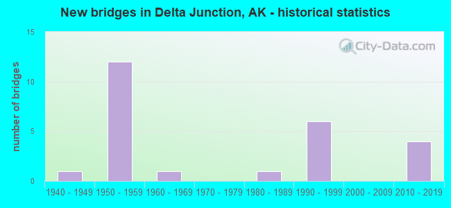
- New bridges - historical statistics
- 11940-1949
- 121950-1959
- 11960-1969
- 11980-1989
- 61990-1999
- 42010-2019

- Reconstructed bridges - Historical Statistics
- 11940-1949
- 01950-1959
- 01960-1969
- 11970-1979


- Bridge Condition - Deck
- 4.3%Excellent
- 34.8%Very good
- 13.0%Good
- 26.1%Satisfactory
- 8.7%Fair
- 13.0%Poor

- Bridge Condition - Superstructure
- 4.3%Excellent
- 30.4%Very good
- 13.0%Good
- 43.5%Satisfactory
- 8.7%Fair

- Bridge Condition - Substructure
- 4.3%Excellent
- 13.0%Very good
- 8.7%Good
- 30.4%Satisfactory
- 39.1%Fair
- 4.3%Poor

- Bridge Condition - Channel
- 16.0%Excellent
- 24.0%Very good
- 20.0%Good
- 28.0%Satisfactory
- 8.0%Fair
- 4.0%Poor
Find on map >> Show street view
Structure Number: 515, Location: MILE POINT 147.3 (Lat: 63.692236, Lng: -144.369733), Route carried "on" structure: Interstate A21, Year Built: 1990, Status: Open, Structure Length: 2.74m (8.99ft), Average Daily Traffic: 190 (year 2020), Truck Traffic: 26%, Average Future Daily Traffic: 260 (year 2039), Design Load: HS 25 or greater, Features Intersected: BERRY CREEK, Facility Carried by Structure: ALASKA HIGHWAY
Minimum Vertical Clearance: 4.72m (15.49ft), Kilometerpoint: 237.045, Lanes on structure: 2, Base Highway Network: Yes, Owner: State Highway Agency, Approaching Roadway Width: 11.0m (36.1ft), Material/Design: Prestressed concrete, Design/Construction: Tee Beam, Number Of Spans In Main Unit: 1, Length of Maximum Span: 27.0m (88.6ft), Curb or Sidewalk Widths: Left: 0.5m (1.6ft), Right: 0.5m (1.6ft), Curb-To-Curb Width: 11.0m (36.1ft), Out-to-Out Width: 11.6m (38.1ft)
Condition: Deck: Very good, Superstructure: Very good, Substructure: Very good, Channel: Good, Operating Rating: 93.7 metric tons, Method Used To Determine Operating Rating: Load Factor (LF), Inventory Rating: 44.8 metric tons, Method Used To Determine Inventory Rating: Load Factor (LF), Structural Evaluation: Equal to present desirable criteria, Deck Geometry: Equal to present desirable criteria, Waterway Adequacy: Superior to present desirable criteria, Approach Roadway Alignment: Superior to present desirable criteria, Designated Inspection Frequency: Every 24 months, Inspection Date: July 2020, Deck Structure Type: Other, Wearing Surface/Protective System: Wearing Surface: Bituminous, Deck Protection: Epoxy Coated Reinforcing
Find on map >> Show street view
Structure Number: 516, Location: MILE POINT 150.2 (Lat: 63.687342, Lng: -144.463456), Route carried "on" structure: Interstate A21, Year Built: 1982, Status: Open, Structure Length: 0.79m (2.59ft), Average Daily Traffic: 190 (year 2020), Truck Traffic: 26%, Average Future Daily Traffic: 260 (year 2039), Design Load: HS 20, Features Intersected: SEARS CREEK, Facility Carried by Structure: ALASKA HIGHWAY
Minimum Vertical Clearance: 4.72m (15.49ft), Kilometerpoint: 241.746, Lanes on structure: 2, Base Highway Network: Yes, Owner: State Highway Agency, Approaching Roadway Width: 11.0m (36.1ft), Material/Design: Prestressed concrete, Design/Construction: Tee Beam, Number Of Spans In Main Unit: 1, Length of Maximum Span: 7.3m (24.0ft), Curb-To-Curb Width: 10.8m (35.4ft), Out-to-Out Width: 11.3m (37.1ft)
Condition: Deck: Good, Superstructure: Good, Substructure: Satisfactory, Channel: Very good, Inventory Rating: 56.5 metric tons, Method Used To Determine Inventory Rating: Load Factor (LF), Structural Evaluation: Equal to present minimum criteria, Deck Geometry: Better than present minimum criteria, Waterway Adequacy: Equal to present minimum criteria, Approach Roadway Alignment: Equal to present minimum criteria, Designated Inspection Frequency: Every 24 months, Inspection Date: July 2020, Deck Structure Type: Other, Wearing Surface/Protective System: Wearing Surface: Bituminous, Membrane: Preformed Fabric
Find on map >> Show street view
Structure Number: 517, Location: MILE POINT 153.8 (Lat: 63.691653, Lng: -144.573239), Route carried "on" structure: Interstate A21, Year Built: 1957, Year Reconstructed: 1977, Status: Open, Structure Length: 1.28m (4.20ft), Average Daily Traffic: 190 (year 2020), Truck Traffic: 26%, Average Future Daily Traffic: 260 (year 2039), Design Load: HS 20, Features Intersected: DRY CREEK, Facility Carried by Structure: ALASKA HIGHWAY
Minimum Vertical Clearance: 4.72m (15.49ft), Kilometerpoint: 247.538, Lanes on structure: 2, Base Highway Network: Yes, Owner: State Highway Agency, Approaching Roadway Width: 11.0m (36.1ft), Material/Design: Steel, Design/Construction: Stringer/Multi-beam, Number Of Spans In Main Unit: 1, Length of Maximum Span: 12.2m (40.0ft), Curb or Sidewalk Widths: Left: 0.0m, Right: 0.2m (0.7ft), Curb-To-Curb Width: 11.1m (36.4ft), Out-to-Out Width: 11.3m (37.1ft)
Condition: Deck: Very good, Superstructure: Satisfactory, Substructure: Fair, Channel: Satisfactory, Operating Rating: 50.5 metric tons, Method Used To Determine Operating Rating: Load Factor (LF), Inventory Rating: 23.3 metric tons, Method Used To Determine Inventory Rating: Load Factor (LF), Structural Evaluation: Somewhat better than minimum adequacy, Deck Geometry: Superior to present desirable criteria, Waterway Adequacy: Equal to present minimum criteria, Approach Roadway Alignment: Equal to present desirable criteria, Designated Inspection Frequency: Every 24 months, Inspection Date: July 2020, Deck Structure Type: Concrete Cast-file-Place, Wearing Surface/Protective System: Wearing Surface: Bituminous
Find on map >> Show street view
Structure Number: 518, Location: MILE POINT 156.1 (Lat: 63.703775, Lng: -144.641592), Route carried "on" structure: Interstate A22, Year Built: 1944, Year Reconstructed: 1952, Status: Open, Structure Length: 29.70m (97.44ft), Average Daily Traffic: 180 (year 2020), Truck Traffic: 28%, Average Future Daily Traffic: 230 (year 2039), Design Load: H 20, Features Intersected: JOHNSON RIVER, Facility Carried by Structure: ALASKA HIGHWAY
Minimum Vertical Clearance: 4.75m (15.58ft), Kilometerpoint: 251.211, Lanes on structure: 2, Base Highway Network: Yes, Owner: State Highway Agency, Approaching Roadway Width: 11.0m (36.1ft), Material/Design: Steel, Design/Construction: Truss - Thru, Number Of Spans In Main Unit: 5, Length of Maximum Span: 61.0m (200.1ft), Curb-To-Curb Width: 7.5m (24.6ft), Out-to-Out Width: 8.2m (26.9ft)
Condition: Deck: Poor, Superstructure: Fair, Substructure: Fair, Channel: Good, Operating Rating: 51.3 metric tons, Method Used To Determine Operating Rating: Load Factor (LF), Inventory Rating: 25.7 metric tons, Method Used To Determine Inventory Rating: Load Factor (LF), Structural Evaluation: Somewhat better than minimum adequacy, Deck Geometry: Meets minimum limits, Waterway Adequacy: Equal to present desirable criteria, Approach Roadway Alignment: Equal to present minimum criteria, Designated Inspection Frequency: Every 24 months, Critical Feature Inspection Frequency: Every 24 months, Underwater Inspection Frequency: Every 60 months, Inspection Date: July 2020, Critical Feature Inspection Date: July 2021, Underwater Inspection Date: July 2020, Deck Structure Type: Wood or Timber, Wearing Surface/Protective System: Wearing Surface: Bituminous, Deck Protection: Other
Find on map >> Show street view
Structure Number: 519, Location: MILE POINT 164.1 (Lat: 63.787342, Lng: -144.793378), Route carried "on" structure: Interstate A22, Year Built: 1999, Status: Open, Structure Length: 6.10m (20.01ft), Average Daily Traffic: 180 (year 2020), Truck Traffic: 28%, Average Future Daily Traffic: 230 (year 2039), Design Load: HS 25 or greater, Features Intersected: LITTLE GERSTLE RIVER, Facility Carried by Structure: ALASKA HIGHWAY
Minimum Vertical Clearance: 4.72m (15.49ft), Kilometerpoint: 264.006, Lanes on structure: 2, Base Highway Network: Yes, Owner: State Highway Agency, Approaching Roadway Width: 11.0m (36.1ft), Skew: 2 degrees, Material/Design: Prestressed concrete, Design/Construction: Tee Beam, Number Of Spans In Main Unit: 2, Length of Maximum Span: 29.9m (98.1ft), Curb-To-Curb Width: 11.0m (36.1ft), Out-to-Out Width: 11.9m (39.0ft)
Condition: Deck: Very good, Superstructure: Very good, Substructure: Satisfactory, Channel: Very good, Operating Rating: 92.4 metric tons, Method Used To Determine Operating Rating: Load Factor (LF), Inventory Rating: 42.6 metric tons, Method Used To Determine Inventory Rating: Load Factor (LF), Structural Evaluation: Equal to present minimum criteria, Deck Geometry: Equal to present desirable criteria, Waterway Adequacy: Equal to present desirable criteria, Approach Roadway Alignment: Equal to present desirable criteria, Designated Inspection Frequency: Every 24 months, Inspection Date: July 2020, Deck Structure Type: Other, Wearing Surface/Protective System: Wearing Surface: Bituminous, Membrane: Preformed Fabric, Deck Protection: Epoxy Coated Reinforcing
Find on map >> Show street view
Structure Number: 521, Location: MILE POINT 179.6 (Lat: 63.898994, Lng: -145.232844), Route carried "on" structure: Interstate A22, Year Built: 1995, Status: Open, Structure Length: 4.24m (13.91ft), Average Daily Traffic: 750 (year 2020), Truck Traffic: 21%, Average Future Daily Traffic: 1,290 (year 2039), Design Load: HS 25 or greater, Features Intersected: SAWMILL CREEK, Facility Carried by Structure: ALASKA HIGHWAY
Minimum Vertical Clearance: 4.72m (15.49ft), Kilometerpoint: 288.983, Lanes on structure: 2, Base Highway Network: Yes, Owner: State Highway Agency, Approaching Roadway Width: 11.0m (36.1ft), Material/Design: Prestressed concrete, Design/Construction: Tee Beam, Number Of Spans In Main Unit: 1, Length of Maximum Span: 42.1m (138.1ft), Curb-To-Curb Width: 11.0m (36.1ft), Out-to-Out Width: 11.9m (39.0ft)
Condition: Deck: Very good, Superstructure: Very good, Substructure: Satisfactory, Channel: Excellent, Operating Rating: 89.8 metric tons, Method Used To Determine Operating Rating: Load Factor (LF), Inventory Rating: 41.3 metric tons, Method Used To Determine Inventory Rating: Load Factor (LF), Structural Evaluation: Equal to present minimum criteria, Deck Geometry: Better than present minimum criteria, Waterway Adequacy: Superior to present desirable criteria, Approach Roadway Alignment: Superior to present desirable criteria, Designated Inspection Frequency: Every 24 months, Inspection Date: July 2020, Deck Structure Type: Other, Wearing Surface/Protective System: Wearing Surface: Bituminous, Membrane: Preformed Fabric, Deck Protection: Epoxy Coated Reinforcing
Find on map >> Show street view
Structure Number: 524, Location: MILE POINT 277.9 (Lat: 64.157342, Lng: -145.852431), Route carried "on" structure: Interstate A23, Year Built: 1966, Status: Open, Structure Length: 23.88m (78.35ft), Average Daily Traffic: 1,990 (year 2020), Truck Traffic: 16%, Average Future Daily Traffic: 2,380 (year 2039), Design Load: H 20, Features Intersected: TANANA RIVER BIG DELTA, Facility Carried by Structure: RICHARDSON HIGHWAY
Minimum Vertical Clearance: 5.46m (17.91ft), Kilometerpoint: 447.296, Lanes on structure: 2, Base Highway Network: Yes, Owner: State Highway Agency, Approaching Roadway Width: 9.8m (32.2ft), Material/Design: Steel, Design/Construction: Truss - Thru, Number Of Spans In Main Unit: 1, Number Of Approach Spans: 4, Length of Maximum Span: 121.6m (399.0ft), Curb or Sidewalk Widths: Left: 0.5m (1.6ft), Right: 0.5m (1.6ft), Curb-To-Curb Width: 9.1m (29.9ft), Out-to-Out Width: 10.4m (34.1ft)
Condition: Deck: Satisfactory, Superstructure: Satisfactory, Substructure: Satisfactory, Channel: Satisfactory, Operating Rating: 66.8 metric tons, Method Used To Determine Operating Rating: Load Factor (LF), Inventory Rating: 26.9 metric tons, Method Used To Determine Inventory Rating: Load Factor (LF), Structural Evaluation: Equal to present minimum criteria, Deck Geometry: Somewhat better than minimum adequacy, Waterway Adequacy: Equal to present desirable criteria, Approach Roadway Alignment: Equal to present minimum criteria, Designated Inspection Frequency: Every 24 months, Critical Feature Inspection Frequency: Every 24 months, Underwater Inspection Frequency: Every 60 months, Inspection Date: July 2020, Critical Feature Inspection Date: July 2021, Underwater Inspection Date: September 2020, Deck Structure Type: Concrete Cast-file-Place, Wearing Surface/Protective System: Wearing Surface: Monolithic Concrete
Find on map >> Show street view
Structure Number: 525, Location: MILE POINT 289.0 (Lat: 64.260139, Lng: -146.107822), Route carried "on" structure: Interstate A23, Year Built: 2011, Status: Open, Structure Length: 5.49m (18.01ft), Average Daily Traffic: 1,000 (year 2020), Truck Traffic: 18%, Average Future Daily Traffic: 1,190 (year 2039), Design Load: HL 93, Features Intersected: SHAW CREEK, Facility Carried by Structure: RICHARDSON HIGHWAY
Minimum Vertical Clearance: 5.46m (17.91ft), Kilometerpoint: 465.125, Lanes on structure: 2, Base Highway Network: Yes, Owner: State Highway Agency, Approaching Roadway Width: 12.2m (40.0ft), Skew: 3 degrees, Navigation Control: Yes ( Vertical Clearance: 1.8m (5.9ft), Horizontal Clearance: 15.2m (49.9ft)), Material/Design: Prestressed concrete, Design/Construction: Tee Beam, Number Of Spans In Main Unit: 3, Length of Maximum Span: 18.3m (60.0ft), Curb-To-Curb Width: 12.2m (40.0ft), Out-to-Out Width: 13.1m (43.0ft)
Condition: Deck: Very good, Superstructure: Very good, Substructure: Good, Channel: Very good, Operating Rating: 87.7 metric tons, Method Used To Determine Operating Rating: Load Factor (LF), Inventory Rating: 40.4 metric tons, Method Used To Determine Inventory Rating: Load Factor (LF), Structural Evaluation: Better than present minimum criteria, Deck Geometry: Equal to present desirable criteria, Waterway Adequacy: Equal to present desirable criteria, Approach Roadway Alignment: Equal to present desirable criteria, Designated Inspection Frequency: Every 24 months, Inspection Date: July 2020, Deck Structure Type: Other, Wearing Surface/Protective System: Wearing Surface: Bituminous, Membrane: Preformed Fabric, Deck Protection: Epoxy Coated Reinforcing
Find on map >> Show street view
Structure Number: 58, Location: MILE POINT 205.2 (Lat: 63.223400, Lng: -145.651600), Route carried "on" structure: State highway 71, Year Built: 1954, Status: Open, Structure Length: 1.02m (3.35ft), Average Daily Traffic: 280 (year 2020), Truck Traffic: 21%, Average Future Daily Traffic: 330 (year 2039), Design Load: H 20, Features Intersected: MCCALLUM CREEK, Facility Carried by Structure: RICHARDSON HIGHWAY
Minimum Vertical Clearance: 5.46m (17.91ft), Kilometerpoint: 330.220, Lanes on structure: 2, Base Highway Network: Yes, Owner: State Highway Agency, Approaching Roadway Width: 7.3m (24.0ft), Material/Design: Steel, Design/Construction: Stringer/Multi-beam, Number Of Spans In Main Unit: 1, Length of Maximum Span: 9.5m (31.2ft), Curb-To-Curb Width: 7.3m (24.0ft), Out-to-Out Width: 7.7m (25.3ft)
Condition: Deck: Satisfactory, Superstructure: Fair, Substructure: Fair, Channel: Good, Operating Rating: 48.6 metric tons, Method Used To Determine Operating Rating: Load Factor (LF), Inventory Rating: 22.4 metric tons, Method Used To Determine Inventory Rating: Load Factor (LF), Structural Evaluation: Somewhat better than minimum adequacy, Deck Geometry: Somewhat better than minimum adequacy, Waterway Adequacy: Equal to present desirable criteria, Approach Roadway Alignment: Equal to present minimum criteria, Designated Inspection Frequency: Every 24 months, Inspection Date: July 2021, Deck Structure Type: Concrete Cast-file-Place, Wearing Surface/Protective System: Wearing Surface: Monolithic Concrete
Find on map >> Show street view
Structure Number: 582, Location: MILE POINT 219.5 (Lat: 63.396500, Lng: -145.735200), Route carried "on" structure: State highway 71, Year Built: 1958, Status: Open, Structure Length: 4.64m (15.22ft), Average Daily Traffic: 280 (year 2020), Truck Traffic: 21%, Average Future Daily Traffic: 330 (year 2039), Design Load: H 20, Features Intersected: LOWER MILLER CREEK, Facility Carried by Structure: RICHARDSON HIGHWAY
Minimum Vertical Clearance: 5.46m (17.91ft), Kilometerpoint: 353.224, Lanes on structure: 2, Base Highway Network: Yes, Owner: State Highway Agency, Approaching Roadway Width: 7.3m (24.0ft), Material/Design: Steel, Design/Construction: Stringer/Multi-beam, Number Of Spans In Main Unit: 3, Length of Maximum Span: 15.0m (49.2ft), Curb-To-Curb Width: 7.3m (24.0ft), Out-to-Out Width: 7.7m (25.3ft)
Condition: Deck: Fair, Superstructure: Satisfactory, Substructure: Satisfactory, Channel: Satisfactory, Operating Rating: 51.6 metric tons, Method Used To Determine Operating Rating: Load Factor (LF), Inventory Rating: 23.8 metric tons, Method Used To Determine Inventory Rating: Load Factor (LF), Structural Evaluation: Equal to present minimum criteria, Deck Geometry: Somewhat better than minimum adequacy, Waterway Adequacy: Equal to present minimum criteria, Approach Roadway Alignment: Equal to present minimum criteria, Designated Inspection Frequency: Every 24 months, Inspection Date: July 2021, Deck Structure Type: Concrete Cast-file-Place, Wearing Surface/Protective System: Wearing Surface: Monolithic Concrete
Find on map >> Show street view
Structure Number: 583, Location: MILE POINT 219.9 (Lat: 63.402778, Lng: -145.735278), Route carried "on" structure: State highway 71, Year Built: 1958, Status: Open, Structure Length: 4.66m (15.29ft), Average Daily Traffic: 280 (year 2020), Truck Traffic: 21%, Average Future Daily Traffic: 330 (year 2039), Design Load: H 20, Features Intersected: CASTNER CREEK, Facility Carried by Structure: RICHARDSON HIGHWAY
Minimum Vertical Clearance: 5.46m (17.91ft), Kilometerpoint: 353.933, Lanes on structure: 2, Base Highway Network: Yes, Owner: State Highway Agency, Approaching Roadway Width: 8.5m (27.9ft), Material/Design: Steel continuous, Design/Construction: Stringer/Multi-beam, Number Of Spans In Main Unit: 3, Length of Maximum Span: 18.0m (59.1ft), Curb-To-Curb Width: 7.3m (24.0ft), Out-to-Out Width: 7.9m (25.9ft)
Condition: Deck: Poor, Superstructure: Satisfactory, Substructure: Poor, Channel: Fair, Operating Rating: 53.2 metric tons, Method Used To Determine Operating Rating: Load Factor (LF), Inventory Rating: 24.5 metric tons, Method Used To Determine Inventory Rating: Load Factor (LF), Structural Evaluation: Meets minimum limits, Deck Geometry: Somewhat better than minimum adequacy, Waterway Adequacy: Equal to present minimum criteria, Approach Roadway Alignment: Better than present minimum criteria, Designated Inspection Frequency: Every 24 months, Inspection Date: July 2021, Deck Structure Type: Concrete Cast-file-Place, Wearing Surface/Protective System: Wearing Surface: Monolithic Concrete
Find on map >> Show street view
Structure Number: 584, Location: MILE POINT 221.6 (Lat: 63.423611, Lng: -145.758056), Route carried "on" structure: State highway 71, Year Built: 1954, Status: Open, Structure Length: 1.14m (3.74ft), Average Daily Traffic: 280 (year 2020), Truck Traffic: 21%, Average Future Daily Traffic: 330 (year 2039), Design Load: H 20, Features Intersected: TRIMS CREEK, Facility Carried by Structure: RICHARDSON HIGHWAY
Minimum Vertical Clearance: 5.46m (17.91ft), Kilometerpoint: 356.558, Lanes on structure: 2, Base Highway Network: Yes, Owner: State Highway Agency, Approaching Roadway Width: 7.3m (24.0ft), Material/Design: Steel, Design/Construction: Stringer/Multi-beam, Number Of Spans In Main Unit: 1, Length of Maximum Span: 10.7m (35.1ft), Curb-To-Curb Width: 7.3m (24.0ft), Out-to-Out Width: 7.7m (25.3ft)
Condition: Deck: Satisfactory, Superstructure: Satisfactory, Substructure: Fair, Channel: Satisfactory, Operating Rating: 47.4 metric tons, Method Used To Determine Operating Rating: Load Factor (LF), Inventory Rating: 21.8 metric tons, Method Used To Determine Inventory Rating: Load Factor (LF), Structural Evaluation: Somewhat better than minimum adequacy, Deck Geometry: Somewhat better than minimum adequacy, Waterway Adequacy: Equal to present minimum criteria, Approach Roadway Alignment: Equal to present minimum criteria, Designated Inspection Frequency: Every 24 months, Inspection Date: July 2021, Deck Structure Type: Concrete Cast-file-Place, Wearing Surface/Protective System: Wearing Surface: Monolithic Concrete
Find on map >> Show street view
Structure Number: 585, Location: MILE POINT 223.6 (Lat: 63.434444, Lng: -145.781111), Route carried "on" structure: State highway 71, Year Built: 1954, Status: Open, Structure Length: 1.02m (3.35ft), Average Daily Traffic: 280 (year 2020), Truck Traffic: 21%, Average Future Daily Traffic: 330 (year 2039), Design Load: H 20, Features Intersected: MICHAEL CREEK, Facility Carried by Structure: RICHARDSON HIGHWAY
Minimum Vertical Clearance: 5.46m (17.91ft), Kilometerpoint: 359.872, Lanes on structure: 2, Base Highway Network: Yes, Owner: State Highway Agency, Approaching Roadway Width: 8.2m (26.9ft), Material/Design: Steel, Design/Construction: Stringer/Multi-beam, Number Of Spans In Main Unit: 1, Length of Maximum Span: 9.5m (31.2ft), Curb-To-Curb Width: 7.3m (24.0ft), Out-to-Out Width: 7.7m (25.3ft)
Condition: Deck: Good, Superstructure: Satisfactory, Substructure: Satisfactory, Channel: Very good, Operating Rating: 47.1 metric tons, Method Used To Determine Operating Rating: Load Factor (LF), Inventory Rating: 21.7 metric tons, Method Used To Determine Inventory Rating: Load Factor (LF), Structural Evaluation: Equal to present minimum criteria, Deck Geometry: Somewhat better than minimum adequacy, Waterway Adequacy: Equal to present minimum criteria, Approach Roadway Alignment: Equal to present minimum criteria, Designated Inspection Frequency: Every 24 months, Inspection Date: July 2021, Deck Structure Type: Concrete Cast-file-Place, Wearing Surface/Protective System: Wearing Surface: Monolithic Concrete
Find on map >> Show street view
Structure Number: 586, Location: MILE POINT 223.9 (Lat: 63.445278, Lng: -145.802222), Route carried "on" structure: State highway 71, Year Built: 1954, Status: Open, Structure Length: 1.14m (3.74ft), Average Daily Traffic: 280 (year 2020), Truck Traffic: 21%, Average Future Daily Traffic: 330 (year 2039), Design Load: H 20, Features Intersected: FLOOD CREEK, Facility Carried by Structure: RICHARDSON HIGHWAY
Minimum Vertical Clearance: 5.46m (17.91ft), Kilometerpoint: 360.345, Lanes on structure: 2, Base Highway Network: Yes, Owner: State Highway Agency, Approaching Roadway Width: 8.5m (27.9ft), Material/Design: Steel, Design/Construction: Stringer/Multi-beam, Number Of Spans In Main Unit: 1, Length of Maximum Span: 10.7m (35.1ft), Curb-To-Curb Width: 7.3m (24.0ft), Out-to-Out Width: 7.7m (25.3ft)
Condition: Deck: Satisfactory, Superstructure: Satisfactory, Substructure: Fair, Channel: Good, Operating Rating: 46.1 metric tons, Method Used To Determine Operating Rating: Load Factor (LF), Inventory Rating: 21.2 metric tons, Method Used To Determine Inventory Rating: Load Factor (LF), Structural Evaluation: Somewhat better than minimum adequacy, Deck Geometry: Somewhat better than minimum adequacy, Waterway Adequacy: Equal to present minimum criteria, Approach Roadway Alignment: Equal to present minimum criteria, Designated Inspection Frequency: Every 24 months, Inspection Date: July 2021, Deck Structure Type: Concrete Cast-file-Place, Wearing Surface/Protective System: Wearing Surface: Monolithic Concrete
Find on map >> Show street view
Structure Number: 587, Location: MILE POINT 225.8 (Lat: 63.469444, Lng: -145.845000), Route carried "on" structure: State highway 71, Year Built: 1954, Status: Open, Structure Length: 1.14m (3.74ft), Average Daily Traffic: 280 (year 2020), Truck Traffic: 21%, Average Future Daily Traffic: 330 (year 2039), Design Load: H 20, Features Intersected: WHISTLER CREEK, Facility Carried by Structure: RICHARDSON HIGHWAY
Minimum Vertical Clearance: 5.46m (17.91ft), Kilometerpoint: 363.342, Lanes on structure: 2, Base Highway Network: Yes, Owner: State Highway Agency, Approaching Roadway Width: 7.3m (24.0ft), Material/Design: Steel, Design/Construction: Stringer/Multi-beam, Number Of Spans In Main Unit: 1, Length of Maximum Span: 10.7m (35.1ft), Curb-To-Curb Width: 7.3m (24.0ft), Out-to-Out Width: 7.7m (25.3ft)
Condition: Deck: Satisfactory, Superstructure: Satisfactory, Substructure: Fair, Channel: Fair, Operating Rating: 46.2 metric tons, Method Used To Determine Operating Rating: Load Factor (LF), Inventory Rating: 21.2 metric tons, Method Used To Determine Inventory Rating: Load Factor (LF), Structural Evaluation: Somewhat better than minimum adequacy, Deck Geometry: Somewhat better than minimum adequacy, Waterway Adequacy: High priority of corrective action, Approach Roadway Alignment: Better than present minimum criteria, Designated Inspection Frequency: Every 24 months, Inspection Date: July 2021, Deck Structure Type: Concrete Cast-file-Place, Wearing Surface/Protective System: Wearing Surface: Monolithic Concrete
Find on map >> Show street view
Structure Number: 588, Location: MILE POINT 226.5 (Lat: 63.479700, Lng: -145.854000), Route carried "on" structure: State highway 71, Year Built: 1954, Status: Open, Structure Length: 1.14m (3.74ft), Average Daily Traffic: 280 (year 2020), Truck Traffic: 21%, Average Future Daily Traffic: 330 (year 2039), Design Load: H 20, Features Intersected: BOULDER CREEK, Facility Carried by Structure: RICHARDSON HIGHWAY
Minimum Vertical Clearance: 5.46m (17.91ft), Kilometerpoint: 364.563, Lanes on structure: 2, Base Highway Network: Yes, Owner: State Highway Agency, Approaching Roadway Width: 7.3m (24.0ft), Material/Design: Steel, Design/Construction: Stringer/Multi-beam, Number Of Spans In Main Unit: 1, Length of Maximum Span: 10.7m (35.1ft), Curb-To-Curb Width: 7.3m (24.0ft), Out-to-Out Width: 7.7m (25.3ft)
Condition: Deck: Satisfactory, Superstructure: Satisfactory, Substructure: Fair, Channel: Poor, Operating Rating: 46.2 metric tons, Method Used To Determine Operating Rating: Load Factor (LF), Inventory Rating: 21.2 metric tons, Method Used To Determine Inventory Rating: Load Factor (LF), Structural Evaluation: Somewhat better than minimum adequacy, Deck Geometry: Somewhat better than minimum adequacy, Waterway Adequacy: High priority of corrective action, Approach Roadway Alignment: Better than present minimum criteria, Designated Inspection Frequency: Every 24 months, Inspection Date: July 2021, Deck Structure Type: Concrete Cast-file-Place, Wearing Surface/Protective System: Wearing Surface: Monolithic Concrete
Find on map >> Show street view
Structure Number: 589, Location: MILE POINT 227.3 (Lat: 63.490200, Lng: -145.858200), Route carried "on" structure: State highway 71, Year Built: 1990, Status: Open, Structure Length: 1.10m (3.61ft), Average Daily Traffic: 280 (year 2020), Truck Traffic: 21%, Average Future Daily Traffic: 330 (year 2039), Design Load: HS 25 or greater, Features Intersected: LOWER SUZY Q CREEK, Facility Carried by Structure: RICHARDSON HIGHWAY
Minimum Vertical Clearance: 5.46m (17.91ft), Kilometerpoint: 365.749, Lanes on structure: 2, Base Highway Network: Yes, Owner: State Highway Agency, Approaching Roadway Width: 7.3m (24.0ft), Skew: 4 degrees, Material/Design: Prestressed concrete, Design/Construction: Tee Beam, Number Of Spans In Main Unit: 1, Length of Maximum Span: 10.7m (35.1ft), Curb-To-Curb Width: 8.5m (27.9ft), Out-to-Out Width: 9.4m (30.8ft)
Condition: Deck: Very good, Superstructure: Very good, Substructure: Good, Channel: Good, Operating Rating: 82.9 metric tons, Method Used To Determine Operating Rating: Load Factor (LF), Inventory Rating: 38.2 metric tons, Method Used To Determine Inventory Rating: Load Factor (LF), Structural Evaluation: Better than present minimum criteria, Deck Geometry: Equal to present minimum criteria, Waterway Adequacy: Equal to present minimum criteria, Approach Roadway Alignment: Equal to present minimum criteria, Designated Inspection Frequency: Every 24 months, Inspection Date: July 2021, Deck Structure Type: Other, Wearing Surface/Protective System: Wearing Surface: Bituminous, Deck Protection: Epoxy Coated Reinforcing
Find on map >> Show street view
Structure Number: 59, Location: MILE POINT 229.7 (Lat: 63.524444, Lng: -145.854722), Route carried "on" structure: State highway 71, Year Built: 1954, Status: Open, Structure Length: 1.43m (4.69ft), Average Daily Traffic: 240 (year 2020), Truck Traffic: 14%, Average Future Daily Traffic: 280 (year 2039), Design Load: H 20, Features Intersected: GUNNY SACK CREEK, Facility Carried by Structure: RICHARDSON HIGHWAY
Minimum Vertical Clearance: 5.46m (17.91ft), Kilometerpoint: 369.639, Lanes on structure: 2, Base Highway Network: Yes, Owner: State Highway Agency, Approaching Roadway Width: 7.3m (24.0ft), Material/Design: Steel, Design/Construction: Stringer/Multi-beam, Number Of Spans In Main Unit: 1, Length of Maximum Span: 13.4m (44.0ft), Curb-To-Curb Width: 7.3m (24.0ft), Out-to-Out Width: 7.9m (25.9ft)
Condition: Deck: Good, Superstructure: Good, Substructure: Fair, Channel: Satisfactory, Operating Rating: 50.0 metric tons, Method Used To Determine Operating Rating: Load Factor (LF), Inventory Rating: 23.0 metric tons, Method Used To Determine Inventory Rating: Load Factor (LF), Structural Evaluation: Somewhat better than minimum adequacy, Deck Geometry: Somewhat better than minimum adequacy, Waterway Adequacy: Meets minimum limits, Approach Roadway Alignment: Equal to present minimum criteria, Designated Inspection Frequency: Every 24 months, Inspection Date: July 2021, Deck Structure Type: Concrete Cast-file-Place, Wearing Surface/Protective System: Wearing Surface: Monolithic Concrete
Find on map >> Show street view
Structure Number: 591, Location: MILE POINT 231.1 (Lat: 63.544300, Lng: -145.864700), Route carried "on" structure: State highway 71, Year Built: 2012, Status: Open, Structure Length: 3.35m (10.99ft), Average Daily Traffic: 240 (year 2020), Truck Traffic: 4%, Average Future Daily Traffic: 280 (year 2039), Design Load: HL 93, Features Intersected: ONEMILE CREEK, Facility Carried by Structure: RICHARDSON HIGHWAY
Minimum Vertical Clearance: 5.46m (17.91ft), Kilometerpoint: 371.935, Lanes on structure: 2, Base Highway Network: Yes, Owner: State Highway Agency, Approaching Roadway Width: 12.2m (40.0ft), Material/Design: Prestressed concrete, Design/Construction: Tee Beam, Number Of Spans In Main Unit: 1, Length of Maximum Span: 32.6m (107.0ft), Curb-To-Curb Width: 12.2m (40.0ft), Out-to-Out Width: 13.1m (43.0ft)
Condition: Deck: Excellent, Superstructure: Very good, Substructure: Excellent, Channel: Excellent, Operating Rating: 87.7 metric tons, Method Used To Determine Operating Rating: Load Factor (LF), Inventory Rating: 40.4 metric tons, Method Used To Determine Inventory Rating: Load Factor (LF), Structural Evaluation: Equal to present desirable criteria, Deck Geometry: Superior to present desirable criteria, Waterway Adequacy: Superior to present desirable criteria, Approach Roadway Alignment: Equal to present desirable criteria, Designated Inspection Frequency: Every 24 months, Inspection Date: July 2021, Deck Structure Type: Other, Wearing Surface/Protective System: Wearing Surface: Bituminous, Membrane: Preformed Fabric, Deck Protection: Epoxy Coated Reinforcing
Find on map >> Show street view
Structure Number: 592, Location: MILE POINT 233.8 (Lat: 63.581200, Lng: -145.866600), Route carried "on" structure: State highway 71, Year Built: 1952, Status: Open, Structure Length: 2.49m (8.17ft), Average Daily Traffic: 240 (year 2020), Truck Traffic: 14%, Average Future Daily Traffic: 280 (year 2039), Design Load: H 20, Features Intersected: DARLING CREEK, Facility Carried by Structure: RICHARDSON HIGHWAY
Minimum Vertical Clearance: 5.46m (17.91ft), Kilometerpoint: 376.181, Lanes on structure: 2, Base Highway Network: Yes, Owner: State Highway Agency, Approaching Roadway Width: 7.3m (24.0ft), Material/Design: Steel, Design/Construction: Stringer/Multi-beam, Number Of Spans In Main Unit: 1, Length of Maximum Span: 24.2m (79.4ft), Curb-To-Curb Width: 7.3m (24.0ft), Out-to-Out Width: 7.7m (25.3ft)
Condition: Deck: Fair, Superstructure: Satisfactory, Substructure: Satisfactory, Channel: Satisfactory, Operating Rating: 52.6 metric tons, Method Used To Determine Operating Rating: Load Factor (LF), Inventory Rating: 24.2 metric tons, Method Used To Determine Inventory Rating: Load Factor (LF), Structural Evaluation: Equal to present minimum criteria, Deck Geometry: Somewhat better than minimum adequacy, Waterway Adequacy: High priority of corrective action, Approach Roadway Alignment: Equal to present minimum criteria, Designated Inspection Frequency: Every 24 months, Inspection Date: July 2021, Deck Structure Type: Concrete Cast-file-Place, Wearing Surface/Protective System: Wearing Surface: Monolithic Concrete
Find on map >> Show street view
Structure Number: 593, Location: MILE POINT 236.1 (Lat: 63.613056, Lng: -145.864444), Route carried "on" structure: State highway 71, Year Built: 1952, Status: Open, Structure Length: 1.57m (5.15ft), Average Daily Traffic: 240 (year 2020), Truck Traffic: 14%, Average Future Daily Traffic: 280 (year 2039), Design Load: H 20, Features Intersected: BEAR CREEK, Facility Carried by Structure: RICHARDSON HIGHWAY
Minimum Vertical Clearance: 5.46m (17.91ft), Kilometerpoint: 379.884, Lanes on structure: 2, Base Highway Network: Yes, Owner: State Highway Agency, Approaching Roadway Width: 7.3m (24.0ft), Material/Design: Steel, Design/Construction: Stringer/Multi-beam, Number Of Spans In Main Unit: 1, Length of Maximum Span: 15.0m (49.2ft), Curb-To-Curb Width: 7.3m (24.0ft), Out-to-Out Width: 7.7m (25.3ft)
Condition: Deck: Poor, Superstructure: Good, Substructure: Fair, Channel: Satisfactory, Operating Rating: 48.4 metric tons, Method Used To Determine Operating Rating: Load Factor (LF), Inventory Rating: 22.3 metric tons, Method Used To Determine Inventory Rating: Load Factor (LF), Structural Evaluation: Somewhat better than minimum adequacy, Deck Geometry: Somewhat better than minimum adequacy, Waterway Adequacy: High priority of corrective action, Approach Roadway Alignment: Equal to present minimum criteria, Designated Inspection Frequency: Every 24 months, Inspection Date: July 2021, Deck Structure Type: Concrete Cast-file-Place, Wearing Surface/Protective System: Wearing Surface: Bituminous
Find on map >> Show street view
Structure Number: 594, Location: MILE POINT 237.5 (Lat: 63.630361, Lng: -145.889444), Route carried "on" structure: State highway 71, Year Built: 2017, Status: Open, Structure Length: 4.39m (14.40ft), Average Daily Traffic: 240 (year 2020), Truck Traffic: 14%, Average Future Daily Traffic: 280 (year 2039), Design Load: HL 93, Features Intersected: RUBY CREEK, Facility Carried by Structure: RICHARDSON HIGHWAY
Minimum Vertical Clearance: 5.46m (17.91ft), Kilometerpoint: 382.219, Lanes on structure: 2, Base Highway Network: Yes, Owner: State Highway Agency, Approaching Roadway Width: 11.0m (36.1ft), Material/Design: Prestressed concrete, Design/Construction: Tee Beam, Number Of Spans In Main Unit: 1, Length of Maximum Span: 42.7m (140.1ft), Curb-To-Curb Width: 11.0m (36.1ft), Out-to-Out Width: 11.9m (39.0ft)
Condition: Deck: Very good, Superstructure: Excellent, Substructure: Very good, Channel: Excellent, Operating Rating: 87.7 metric tons, Method Used To Determine Operating Rating: Load Factor (LF), Inventory Rating: 40.4 metric tons, Method Used To Determine Inventory Rating: Load Factor (LF), Structural Evaluation: Equal to present desirable criteria, Deck Geometry: Equal to present desirable criteria, Waterway Adequacy: Equal to present desirable criteria, Approach Roadway Alignment: Better than present minimum criteria, Designated Inspection Frequency: Every 24 months, Inspection Date: July 2021, Deck Structure Type: Other, Wearing Surface/Protective System: Wearing Surface: Bituminous, Membrane: Preformed Fabric, Deck Protection: Epoxy Coated Reinforcing
Find on map >> Show street view
Structure Number: 595, Location: MILE POINT 267.6 (Lat: 64.023200, Lng: -145.725200), Route carried "on" structure: State highway 71, Year Built: 2015, Status: Open, Structure Length: 7.47m (24.51ft), Average Daily Traffic: 1,880 (year 2020), Truck Traffic: 13%, Average Future Daily Traffic: 2,370 (year 2039), Design Load: HL 93, Features Intersected: JARVIS CREEK, Facility Carried by Structure: RICHARDSON HIGHWAY
Minimum Vertical Clearance: 5.46m (17.91ft), Kilometerpoint: 430.660, Lanes on structure: 2, Base Highway Network: Yes, Owner: State Highway Agency, Approaching Roadway Width: 12.2m (40.0ft), Material/Design: Prestressed concrete, Design/Construction: Tee Beam, Number Of Spans In Main Unit: 2, Length of Maximum Span: 36.6m (120.1ft), Curb-To-Curb Width: 12.2m (40.0ft), Out-to-Out Width: 13.1m (43.0ft)
Condition: Deck: Very good, Superstructure: Very good, Substructure: Very good, Channel: Excellent, Operating Rating: 87.7 metric tons, Method Used To Determine Operating Rating: Load Factor (LF), Inventory Rating: 40.4 metric tons, Method Used To Determine Inventory Rating: Load Factor (LF), Structural Evaluation: Equal to present desirable criteria, Deck Geometry: Better than present minimum criteria, Waterway Adequacy: Superior to present desirable criteria, Approach Roadway Alignment: Equal to present desirable criteria, Designated Inspection Frequency: Every 24 months, Inspection Date: July 2021, Deck Structure Type: Other, Wearing Surface/Protective System: Wearing Surface: Bituminous, Membrane: Preformed Fabric, Deck Protection: Epoxy Coated Reinforcing
Find on map >> Show street view
Structure Number: 4037, Location: MILE POINT 1.1 (Lat: 64.041200, Lng: -145.679700), Route carried "on" structure: ServiceCity street , Year Built: 1996, Status: Open, Structure Length: 1.04m (3.41ft), Average Daily Traffic: 1,250 (year 2020), Truck Traffic: 10%, Average Future Daily Traffic: 1,520 (year 2039), Design Load: HS 20, Features Intersected: JARVIS CREEK OVERFLOW #2, Facility Carried by Structure: DELTA-NISTLER ROAD
Minimum Vertical Clearance: 30+ m (98+ ft), Kilometerpoint: 1.770, Lanes on structure: 2, Owner: State Highway Agency, Approaching Roadway Width: 9.1m (29.9ft), Material/Design: Concrete, Design/Construction: Culvert, Number Of Spans In Main Unit: 5, Length of Maximum Span: 1.8m (5.9ft), Curb-To-Curb Width: 9.1m (29.9ft), Out-to-Out Width: 10.1m (33.1ft)
Condition: Channel: Very good, Culverts: Good, Operating Rating: 73.2 metric tons, Method Used To Determine Operating Rating: Load Factor (LF), Inventory Rating: 33.7 metric tons, Method Used To Determine Inventory Rating: Load Factor (LF), Structural Evaluation: Better than present minimum criteria, Deck Geometry: Somewhat better than minimum adequacy, Waterway Adequacy: Superior to present desirable criteria, Approach Roadway Alignment: Superior to present desirable criteria, Designated Inspection Frequency: Every 24 months, Inspection Date: July 2021, Deck Structure Type: Concrete Cast-file-Place, Wearing Surface/Protective System: Wearing Surface: Bituminous, Membrane: Preformed Fabric, Deck Protection: Epoxy Coated Reinforcing
Find on map >> Show street view
Structure Number: 4038, Location: MILE POINT 1.2 (Lat: 64.041200, Lng: -145.678500), Route carried "on" structure: ServiceCity street , Year Built: 1996, Status: Open, Structure Length: 1.04m (3.41ft), Average Daily Traffic: 1,250 (year 2020), Truck Traffic: 10%, Average Future Daily Traffic: 1,520 (year 2039), Design Load: HS 20, Features Intersected: JARVIS CREEK OVERFLOW #3, Facility Carried by Structure: DELTA-NISTLER ROAD
Minimum Vertical Clearance: 30+ m (98+ ft), Kilometerpoint: 1.931, Lanes on structure: 2, Owner: State Highway Agency, Approaching Roadway Width: 9.1m (29.9ft), Material/Design: Concrete, Design/Construction: Culvert, Number Of Spans In Main Unit: 5, Length of Maximum Span: 1.8m (5.9ft), Curb-To-Curb Width: 9.1m (29.9ft), Out-to-Out Width: 10.1m (33.1ft)
Condition: Channel: Very good, Culverts: Good, Operating Rating: 73.2 metric tons, Method Used To Determine Operating Rating: Load Factor (LF), Inventory Rating: 33.7 metric tons, Method Used To Determine Inventory Rating: Load Factor (LF), Structural Evaluation: Better than present minimum criteria, Deck Geometry: Somewhat better than minimum adequacy, Waterway Adequacy: Superior to present desirable criteria, Approach Roadway Alignment: Superior to present desirable criteria, Designated Inspection Frequency: Every 24 months, Inspection Date: July 2021, Deck Structure Type: Concrete Cast-file-Place, Wearing Surface/Protective System: Wearing Surface: Bituminous, Membrane: Preformed Fabric, Deck Protection: Epoxy Coated Reinforcing