Bridge Statistics for Delmont, Pennsylvania (PA)
Condition, Traffic, Stress, Structural Evaluation, Project Costs
- National Bridge Inventory (NBI) Statistics
- 13Number of bridges
- 82ft / 25.4mTotal length
- $417,000Total costs
- 104,432Total average daily traffic
- 19,459Total average daily truck traffic
- National Bridge Inventory (NBI) Registered Bridges for Delmont
- No street view available for this location
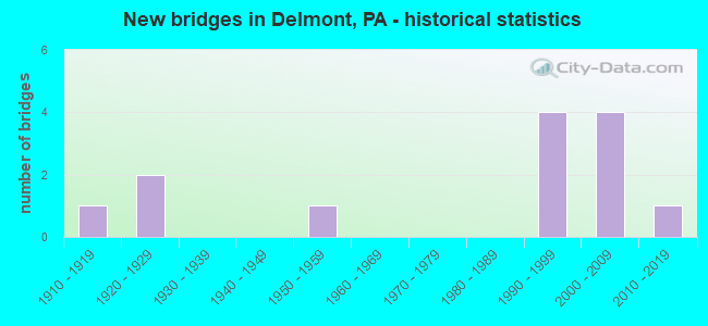
- New bridges - historical statistics
- 11910-1919
- 21920-1929
- 11950-1959
- 41990-1999
- 42000-2009
- 12010-2019

- Reconstructed bridges - Historical Statistics
- 11980-1989
- 01990-1999
- 12000-2009


- Bridge Condition - Deck
- 11.1%Excellent
- 44.4%Good
- 22.2%Satisfactory
- 11.1%Fair
- 11.1%Imminent failure

- Bridge Condition - Superstructure
- 11.1%Excellent
- 11.1%Very good
- 44.4%Good
- 11.1%Satisfactory
- 11.1%Poor
- 11.1%Imminent failure

- Bridge Condition - Substructure
- 11.1%Very good
- 55.6%Good
- 11.1%Satisfactory
- 11.1%Serious
- 11.1%Failed

- Bridge Condition - Channel
- 12.5%Very good
- 25.0%Good
- 25.0%Satisfactory
- 25.0%Fair
- 12.5%Poor
Find on map >> Show street view
Structure Number: 35909, Location: SALEM TOWNSHIP (Lat: 40.400033, Lng: -79.557072), Route carried "on" structure: US 22, Year Built: 1995, Status: Open, Structure Length: 1.46m (4.79ft), Average Daily Traffic: 24,435 (year 2020), Truck Traffic: 20%, Average Future Daily Traffic: 31,321 (year 2032), Design Load: HS 25 or greater, Features Intersected: BEAVER RUN
Minimum Vertical Clearance: 30+ m (98+ ft), Kilometerpoint: 12.643, Lanes on structure: 5, Base Highway Network: Yes, Owner: State Highway Agency, Approaching Roadway Width: 26.8m (87.9ft), Skew: 20 degrees, Material/Design: Prestressed concrete, Design/Construction: Box Beam or Girders - Single/Spread, Number Of Spans In Main Unit: 1, Length of Maximum Span: 14.3m (46.9ft), Curb-To-Curb Width: 25.6m (84.0ft), Out-to-Out Width: 26.7m (87.6ft)
Condition: Deck: Good, Superstructure: Good, Substructure: Good, Channel: Very good, Operating Rating: 78.0 metric tons, Method Used To Determine Operating Rating: Load Factor (LF), Inventory Rating: 46.3 metric tons, Method Used To Determine Inventory Rating: Load Factor (LF), Structural Evaluation: Better than present minimum criteria, Deck Geometry: Superior to present desirable criteria, Waterway Adequacy: Superior to present desirable criteria, Approach Roadway Alignment: Equal to present desirable criteria, Length Of Structure Improvement: 2.10m (6.89ft), Designated Inspection Frequency: Every 48 months, Inspection Date: April 2019, Deck Structure Type: Concrete Cast-file-Place, Wearing Surface/Protective System: Wearing Surface: Monolithic Concrete, Deck Protection: Epoxy Coated Reinforcing
Find on map >> Show street view
Structure Number: 36024, Location: SALEM TOWNSHIP (Lat: 40.391650, Lng: -79.570322), Route carried "on" structure: State highway 66, Year Built: 1950, Year Reconstructed: 1993, Status: Open, Structure Length: 0.73m (2.40ft), Average Daily Traffic: 23,032 (year 2022), Truck Traffic: 19%, Average Future Daily Traffic: 14,029 (year 2032), Design Load: HS 20+Mod, Features Intersected: BEAVER RUN
Minimum Vertical Clearance: 30+ m (98+ ft), Kilometerpoint: 10.445, Lanes on structure: 5, Base Highway Network: Yes, Owner: State Highway Agency, Approaching Roadway Width: 18.3m (60.0ft), Skew: 20 degrees, Material/Design: Concrete, Design/Construction: Culvert, Number Of Spans In Main Unit: 1, Length of Maximum Span: 6.1m (20.0ft)
Condition: Channel: Satisfactory, Culverts: Good, Inventory Rating: 99.8 metric tons, Method Used To Determine Inventory Rating: Load Factor (LF), Structural Evaluation: Better than present minimum criteria, Waterway Adequacy: Superior to present desirable criteria, Approach Roadway Alignment: Equal to present desirable criteria, Length Of Structure Improvement: 1.20m (3.94ft), Designated Inspection Frequency: Every 48 months, Inspection Date: April 2019
Find on map >> Show street view
Structure Number: 36811, Location: SALEM TWP (Lat: 40.386667, Lng: -79.570000), Route carried "on" structure: City street , Year Built: 1993, Status: Open, Structure Length: 10.09m (33.10ft), Average Daily Traffic: 1,000 (year 2008), Truck Traffic: 8%, Average Future Daily Traffic: 1,301 (year 2030), Design Load: HL 93, Features Intersected: PA TPK (PA 66), Facility Carried by Structure: T-627
Minimum Vertical Clearance: 30+ m (98+ ft), Kilometerpoint: 0.000, Lanes on structure: 2, Lanes under structure: 6, Owner: State Toll Authority, Approaching Roadway Width: 15.8m (51.8ft), Skew: 4 degrees, Material/Design: Steel continuous, Design/Construction: Stringer/Multi-beam, Number Of Spans In Main Unit: 2, Length of Maximum Span: 49.4m (162.1ft), Curb or Sidewalk Widths: Left: 0.2m (0.7ft), Right: 0.2m (0.7ft), Curb-To-Curb Width: 15.8m (51.8ft), Out-to-Out Width: 16.9m (55.4ft)
Condition: Deck: Good, Superstructure: Good, Substructure: Good, Operating Rating: 63.8 metric tons, Method Used To Determine Operating Rating: Load and Resistance Factor Rating (LRFR) rating reported by rating factor(RF) method using HL-93 loadings, Inventory Rating: 49.6 metric tons, Method Used To Determine Inventory Rating: Load and Resistance Factor Rating (LRFR) rating reported by rating factor(RF) method using HL-93 loadings, Structural Evaluation: Better than present minimum criteria, Deck Geometry: Superior to present desirable criteria, Underclear: Better than present minimum criteria, Approach Roadway Alignment: Equal to present desirable criteria, Designated Inspection Frequency: Every 48 months, Inspection Date: September 2019, Deck Structure Type: Concrete Cast-file-Place, Wearing Surface/Protective System: Wearing Surface: Latex Concrete, Deck Protection: Epoxy Coated Reinforcing
Find on map >> Show street view
Structure Number: 36951, Location: 250' WEST OF TR 612 (Lat: 40.407167, Lng: -79.556767), Route carried "on" structure: City street T628, Year Built: 2008, Status: Open, Structure Length: 1.62m (5.31ft), Average Daily Traffic: 1,000 (year 1992), Truck Traffic: 10%, Average Future Daily Traffic: 1,100 (year 2010), Design Load: HL 93, Features Intersected: BEAVER RUN, Facility Carried by Structure: EAST PITTSBURGH ST
Minimum Vertical Clearance: 30+ m (98+ ft), Kilometerpoint: 0.000, Lanes on structure: 2, Owner: Town or Township Highway Agency, Approaching Roadway Width: 5.5m (18.0ft), Material/Design: Prestressed concrete, Design/Construction: Box Beam or Girders - Single/Spread, Number Of Spans In Main Unit: 1, Length of Maximum Span: 15.5m (50.9ft), Curb-To-Curb Width: 12.2m (40.0ft), Out-to-Out Width: 12.2m (40.0ft)
Condition: Deck: Good, Superstructure: Good, Substructure: Good, Channel: Good, Operating Rating: 61.7 metric tons, Method Used To Determine Operating Rating: Load and Resistance Factor (LRFR), Inventory Rating: 46.3 metric tons, Method Used To Determine Inventory Rating: Load and Resistance Factor (LRFR), Structural Evaluation: Better than present minimum criteria, Deck Geometry: Equal to present desirable criteria, Waterway Adequacy: Superior to present desirable criteria, Approach Roadway Alignment: Better than present minimum criteria, Length Of Structure Improvement: 1.10m (3.61ft), Designated Inspection Frequency: Every 24 months, Inspection Date: October 2020, Bridge Improvement Cost: $9,000, Roadway Improvement Cost: $57,000, Total Project Cost: $118,000, Deck Structure Type: Concrete Cast-file-Place, Wearing Surface/Protective System: Wearing Surface: Monolithic Concrete, Deck Protection: Epoxy Coated Reinforcing
Find on map >> Show street view
Structure Number: 36953, Location: 600' SW OF TR 617 (Lat: 40.397681, Lng: -79.555225), Route carried "on" structure: City street T658, Year Built: 1915, Status: Closed, Structure Length: 0.73m (2.40ft), Design Load: H 20, Features Intersected: BEAVER RUN, Facility Carried by Structure: MAPLEWOOD DRIVE
Minimum Vertical Clearance: 30+ m (98+ ft), Kilometerpoint: 0.000, Lanes on structure: 1, Owner: Town or Township Highway Agency, Approaching Roadway Width: 3.7m (12.1ft), Material/Design: Steel, Design/Construction: Stringer/Multi-beam, Number Of Spans In Main Unit: 1, Length of Maximum Span: 6.1m (20.0ft), Curb-To-Curb Width: 4.3m (14.1ft), Out-to-Out Width: 4.5m (14.8ft)
Condition: Deck: Imminent failure, Superstructure: Imminent failure, Substructure: Failed, Channel: Fair, Operating Rating: 36.3 metric tons, Method Used To Determine Operating Rating: Load Factor (LF), Inventory Rating: 21.8 metric tons, Method Used To Determine Inventory Rating: Load Factor (LF), Deck Geometry: Equal to present minimum criteria, Waterway Adequacy: Equal to present minimum criteria, Approach Roadway Alignment: Better than present minimum criteria, Bridge Posting: Required (Relationship of Operating Rating to Maximum Legal Load: 20.0 - 29.9% below), Length Of Structure Improvement: 0.70m (2.30ft), Designated Inspection Frequency: Every 24 months, Inspection Date: October 2020, Bridge Improvement Cost: $7,000, Roadway Improvement Cost: $51,000, Total Project Cost: $91,000, Deck Structure Type: Concrete Cast-file-Place, Wearing Surface/Protective System: Wearing Surface: Bituminous
Find on map >> Show street view
Structure Number: 36954, Location: 0.9 MI NORTH OF RT 22 (Lat: 40.413881, Lng: -79.557597), Route carried "on" structure: City street T720, Year Built: 1920, Status: Posted for load, Structure Length: 0.85m (2.79ft), Average Daily Traffic: 60 (year 1992), Truck Traffic: 5%, Average Future Daily Traffic: 80 (year 2010), Design Load: H 15, Features Intersected: BEAVER RUN, Facility Carried by Structure: ROCK SPRINGS RD
Minimum Vertical Clearance: 30+ m (98+ ft), Kilometerpoint: 0.000, Lanes on structure: 1, Base Highway Network: Yes, Owner: Town or Township Highway Agency, Approaching Roadway Width: 4.0m (13.1ft), Material/Design: Steel, Design/Construction: Stringer/Multi-beam, Number Of Spans In Main Unit: 1, Length of Maximum Span: 7.3m (24.0ft), Curb-To-Curb Width: 4.3m (14.1ft), Out-to-Out Width: 4.3m (14.1ft)
Condition: Deck: Fair, Superstructure: Poor, Substructure: Serious, Channel: Fair, Operating Rating: 98.0 metric tons, Method Used To Determine Operating Rating: Load Factor (LF), Inventory Rating: 59.0 metric tons, Method Used To Determine Inventory Rating: Load Factor (LF), Structural Evaluation: High priority of corrective action, Deck Geometry: Equal to present minimum criteria, Waterway Adequacy: High priority of corrective action, Approach Roadway Alignment: Equal to present minimum criteria, Length Of Structure Improvement: 0.90m (2.95ft), Designated Inspection Frequency: Every 24 months, Other Special Inspection Frequency: Every 6 months, Inspection Date: October 2020, Other Special Inspection Date: October 2021, Bridge Improvement Cost: $7,000, Roadway Improvement Cost: $49,000, Total Project Cost: $89,000, Deck Structure Type: Concrete Cast-file-Place, Wearing Surface/Protective System: Wearing Surface: Bituminous
Find on map >> Show street view
Structure Number: 36956, Location: 100' EAST OF TR 610 (Lat: 40.388831, Lng: -79.552403), Route carried "on" structure: City street 883, Year Built: 1994, Status: Open, Structure Length: 0.91m (2.99ft), Average Daily Traffic: 50 (year 1994), Truck Traffic: 1%, Average Future Daily Traffic: 70 (year 2014), Design Load: HS 25 or greater, Features Intersected: BEAVER RUN, Facility Carried by Structure: CROOKED RUN RD
Minimum Vertical Clearance: 30+ m (98+ ft), Kilometerpoint: 0.000, Lanes on structure: 2, Owner: Town or Township Highway Agency, Approaching Roadway Width: 5.5m (18.0ft), Material/Design: Steel, Design/Construction: Stringer/Multi-beam, Number Of Spans In Main Unit: 1, Length of Maximum Span: 8.8m (28.9ft), Curb-To-Curb Width: 5.5m (18.0ft), Out-to-Out Width: 5.5m (18.0ft)
Condition: Deck: Satisfactory, Superstructure: Satisfactory, Substructure: Satisfactory, Channel: Poor, Operating Rating: 61.7 metric tons, Method Used To Determine Operating Rating: Load Factor (LF), Inventory Rating: 36.3 metric tons, Method Used To Determine Inventory Rating: Load Factor (LF), Structural Evaluation: Equal to present minimum criteria, Deck Geometry: Meets minimum limits, Waterway Adequacy: Better than present minimum criteria, Approach Roadway Alignment: Equal to present minimum criteria, Length Of Structure Improvement: 1.60m (5.25ft), Designated Inspection Frequency: Every 24 months, Inspection Date: October 2020, Deck Structure Type: Corrugated Steel, Wearing Surface/Protective System: Wearing Surface: Monolithic Concrete
Find on map >> Show street view
Structure Number: 36958, Location: 0.7 MI WEST OF SR 1061 (Lat: 40.424817, Lng: -79.555164), Route carried "on" structure: City street T921, Year Built: 1920, Year Reconstructed: 2008, Status: Open, Structure Length: 0.98m (3.22ft), Average Daily Traffic: 150 (year 1992), Truck Traffic: 2%, Average Future Daily Traffic: 250 (year 2010), Design Load: HL 93, Features Intersected: BEAVER RUN, Facility Carried by Structure: CHURCH STREET
Minimum Vertical Clearance: 30+ m (98+ ft), Kilometerpoint: 0.000, Lanes on structure: 1, Base Highway Network: Yes, Owner: Town or Township Highway Agency, Approaching Roadway Width: 4.0m (13.1ft), Material/Design: Steel, Design/Construction: Stringer/Multi-beam, Number Of Spans In Main Unit: 1, Length of Maximum Span: 9.1m (29.9ft), Curb-To-Curb Width: 6.8m (22.3ft), Out-to-Out Width: 6.9m (22.6ft)
Condition: Deck: Satisfactory, Superstructure: Good, Substructure: Good, Channel: Satisfactory, Operating Rating: 59.9 metric tons, Method Used To Determine Operating Rating: Load Factor (LF), Inventory Rating: 35.4 metric tons, Method Used To Determine Inventory Rating: Load Factor (LF), Structural Evaluation: Better than present minimum criteria, Deck Geometry: Meets minimum limits, Waterway Adequacy: Equal to present minimum criteria, Approach Roadway Alignment: Somewhat better than minimum adequacy, Length Of Structure Improvement: 1.10m (3.61ft), Designated Inspection Frequency: Every 24 months, Inspection Date: October 2020, Bridge Improvement Cost: $9,000, Roadway Improvement Cost: $58,000, Total Project Cost: $119,000, Deck Structure Type: Concrete Cast-file-Place, Wearing Surface/Protective System: Wearing Surface: Monolithic Concrete
Find on map >> Show street view
Structure Number: 41503, Location: SALEM TWP (Lat: 40.398081, Lng: -79.571122), Route carried "on" structure: US 22, Year Built: 2000, Status: Open, Structure Length: 6.10m (20.01ft), Average Daily Traffic: 24,435 (year 2020), Truck Traffic: 20%, Average Future Daily Traffic: 31,321 (year 2032), Design Load: HL 93, Features Intersected: PA 66
Minimum Vertical Clearance: 30+ m (98+ ft), Kilometerpoint: 11.932, Lanes on structure: 4, Lanes under structure: 6, Base Highway Network: Yes, Owner: State Highway Agency, Approaching Roadway Width: 25.0m (82.0ft), Skew: 30 degrees, Material/Design: Steel, Design/Construction: Stringer/Multi-beam, Number Of Spans In Main Unit: 1, Length of Maximum Span: 59.4m (194.9ft), Curb or Sidewalk Widths: Left: 0.1m (0.3ft), Right: 0.1m (0.3ft), Curb-To-Curb Width: 25.0m (82.0ft), Out-to-Out Width: 26.5m (86.9ft)
Condition: Deck: Good, Superstructure: Very good, Substructure: Good, Inventory Rating: 74.4 metric tons, Method Used To Determine Inventory Rating: Load Factor (LF), Structural Evaluation: Better than present minimum criteria, Deck Geometry: Superior to present desirable criteria, Underclear: Somewhat better than minimum adequacy, Approach Roadway Alignment: Equal to present desirable criteria, Length Of Structure Improvement: 6.90m (22.64ft), Designated Inspection Frequency: Every 48 months, Inspection Date: April 2021, Deck Structure Type: Concrete Cast-file-Place, Wearing Surface/Protective System: Wearing Surface: Monolithic Concrete, Deck Protection: Epoxy Coated Reinforcing
Find on map >> Show street view
Structure Number: 52674, Location: Salem Township (Lat: 40.440539, Lng: -79.543753), Route carried "on" structure: State highway , Year Built: 2015, Status: Open, Structure Length: 1.89m (6.20ft), Average Daily Traffic: 598 (year 2022), Truck Traffic: 4%, Average Future Daily Traffic: 913 (year 2034), Design Load: HL 93, Features Intersected: Beaver Run, Facility Carried by Structure: Athena Dr (SR1034)
Minimum Vertical Clearance: 30+ m (98+ ft), Kilometerpoint: 3.701, Lanes on structure: 2, Owner: State Highway Agency, Maintenance Responsibility: Private, Approaching Roadway Width: 6.1m (20.0ft), Material/Design: Prestressed concrete, Design/Construction: Box Beam or Girders - Multiple, Number Of Spans In Main Unit: 1, Length of Maximum Span: 18.3m (60.0ft), Curb-To-Curb Width: 8.0m (26.2ft), Out-to-Out Width: 8.6m (28.2ft)
Condition: Deck: Excellent, Superstructure: Excellent, Substructure: Very good, Channel: Good, Operating Rating: 65.1 metric tons, Method Used To Determine Operating Rating: Assigned ratings based on Load and Resistance Factor Design (LRFD) reported by rating factor (RF) using HL93 loadings, Inventory Rating: 50.2 metric tons, Method Used To Determine Inventory Rating: Assigned ratings based on Load and Resistance Factor Design (LRFD) reported by rating factor (RF) using HL93 loadings, Structural Evaluation: Equal to present desirable criteria, Deck Geometry: Somewhat better than minimum adequacy, Waterway Adequacy: Better than present minimum criteria, Approach Roadway Alignment: Better than present minimum criteria, Designated Inspection Frequency: Every 24 months, Inspection Date: June 2021, Deck Structure Type: Concrete Cast-file-Place, Wearing Surface/Protective System: Wearing Surface: Integral Concrete, Deck Protection: Epoxy Coated Reinforcing
Find on map >> Show street view
Structure Number: 36811, Location: SALEM TWP (Lat: 40.386667, Lng: -79.570000), Route carried "under" structure: State highway 66, Year Built: 1993, Structure Length: 0. m, Average Daily Traffic: 15,194 (year 2008), Truck Traffic: 15%, Features Intersected: PA TPK (PA 66), Facility Carried by Structure: T-627
Minimum Vertical Clearance: 5.18m (16.99ft), Kilometerpoint: 20.213, Lanes on structure: 2, Lanes under structure: 6, Toll: On toll road, Material/Design: Steel continuous, Design/Construction: Stringer/Multi-beam, Length of Maximum Span: 49.4m (162.1ft)
Find on map >> Show street view
Structure Number: 41503, Location: SALEM TWP (Lat: 40.398081, Lng: -79.571122), Route carried "under" structure: State highway 66, Year Built: 2000, Structure Length: 0. m, Average Daily Traffic: 7,265 (year 2021), Truck Traffic: 18%, Features Intersected: PA 66, Facility Carried by Structure: SR 0022
Minimum Vertical Clearance: 5.18m (16.99ft), Kilometerpoint: 10.445, Lanes on structure: 4, Lanes under structure: 6, Material/Design: Steel, Design/Construction: Stringer/Multi-beam, Length of Maximum Span: 59.4m (194.9ft)
Find on map >> Show street view
Structure Number: 41503, Location: SALEM TWP (Lat: 40.398081, Lng: -79.571122), Route carried "under" structure: State highway 66, Year Built: 2000, Structure Length: 0. m, Average Daily Traffic: 7,213 (year 2021), Truck Traffic: 21%, Features Intersected: PA 66, Facility Carried by Structure: SR 0022
Minimum Vertical Clearance: 5.00m (16.40ft), Kilometerpoint: 11.169, Lanes on structure: 4, Lanes under structure: 6, Material/Design: Steel, Design/Construction: Stringer/Multi-beam, Length of Maximum Span: 59.4m (194.9ft)