Bridge Statistics for Delaware Water Gap, Pennsylvania (PA)
Condition, Traffic, Stress, Structural Evaluation, Project Costs
- National Bridge Inventory (NBI) Statistics
- 33Number of bridges
- 719ft / 219mTotal length
- $4,466,000Total costs
- 407,926Total average daily traffic
- 63,128Total average daily truck traffic
- National Bridge Inventory (NBI) Registered Bridges for Delaware Water Gap
- No street view available for this location
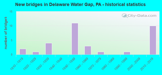
- New bridges - historical statistics
- 21910-1919
- 11920-1929
- 41930-1939
- 111950-1959
- 31960-1969
- 11970-1979
- 11990-1999
- 102010-2019

- Reconstructed bridges - Historical Statistics
- 11950-1959
- 11960-1969
- 11970-1979
- 21980-1989
- 11990-1999
- 12000-2009


- Bridge Condition - Deck
- 15.8%Very good
- 15.8%Good
- 26.3%Satisfactory
- 31.6%Fair
- 10.5%Poor

- Bridge Condition - Superstructure
- 25.0%Very good
- 15.0%Good
- 15.0%Satisfactory
- 30.0%Fair
- 5.0%Poor
- 10.0%Serious

- Bridge Condition - Substructure
- 15.0%Very good
- 10.0%Good
- 45.0%Satisfactory
- 20.0%Fair
- 5.0%Poor
- 5.0%Serious

- Bridge Condition - Channel
- 5.9%Very good
- 17.6%Good
- 17.6%Satisfactory
- 35.3%Fair
- 23.5%Poor

- Bridge Condition - Culverts
- 50.0%Satisfactory
- 50.0%Poor
Find on map >> Show street view
Structure Number: 26744, Location: NEAR PAPERMILL ROAD (Lat: 40.998278, Lng: -75.150389), Route carried "on" structure: Interstate 80, Year Built: 1958, Year Reconstructed: 1976, Status: Open, Structure Length: 15.45m (50.69ft), Average Daily Traffic: 49,671 (year 2022), Truck Traffic: 18%, Average Future Daily Traffic: 63,498 (year 2032), Design Load: HS 20+Mod, Features Intersected: BRODHEAD CREEK / D&LRR
Minimum Vertical Clearance: 30+ m (98+ ft), Kilometerpoint: 42.765, Lanes on structure: 4, Base Highway Network: Yes, Owner: State Highway Agency, Approaching Roadway Width: 19.5m (64.0ft), Skew: 30 degrees, Material/Design: Steel continuous, Design/Construction: Girder and Floorbeam System, Number Of Spans In Main Unit: 3, Length of Maximum Span: 61.0m (200.1ft), Curb or Sidewalk Widths: Left: 0.2m (0.7ft), Right: 0.2m (0.7ft), Curb-To-Curb Width: 17.7m (58.1ft), Out-to-Out Width: 20.0m (65.6ft)
Condition: Deck: Satisfactory, Superstructure: Fair, Substructure: Satisfactory, Channel: Fair, Operating Rating: 49.0 metric tons, Method Used To Determine Operating Rating: Load Factor (LF), Inventory Rating: 29.0 metric tons, Method Used To Determine Inventory Rating: Load Factor (LF), Structural Evaluation: Somewhat better than minimum adequacy, Deck Geometry: Meets minimum limits, Underclear: High priority of corrective action, Waterway Adequacy: Superior to present desirable criteria, Approach Roadway Alignment: Equal to present desirable criteria, Length Of Structure Improvement: 16.50m (54.13ft), Designated Inspection Frequency: Every 24 months, Critical Feature Inspection Frequency: Every 24 months, Underwater Inspection Frequency: Every 57 months, Inspection Date: May 2021, Critical Feature Inspection Date: May 2021, Underwater Inspection Date: January 2021, Bridge Improvement Cost: $78,000, Roadway Improvement Cost: $228,000, Total Project Cost: $1,047,000, Deck Structure Type: Concrete Cast-file-Place, Wearing Surface/Protective System: Wearing Surface: Monolithic Concrete, Deck Protection: Epoxy Coated Reinforcing
Find on map >> Show street view
Structure Number: 26746, Location: I-80 OVER RIVER ROAD (Lat: 40.991528, Lng: -75.141303), Route carried "on" structure: Interstate 80, Year Built: 1958, Status: Open, Structure Length: 0.94m (3.08ft), Average Daily Traffic: 49,671 (year 2022), Truck Traffic: 18%, Average Future Daily Traffic: 63,498 (year 2032), Design Load: HS 20+Mod, Features Intersected: T-663(RIVER ROAD)
Minimum Vertical Clearance: 30+ m (98+ ft), Kilometerpoint: 43.652, Lanes on structure: 4, Lanes under structure: 2, Base Highway Network: Yes, Owner: State Highway Agency, Approaching Roadway Width: 28.0m (91.9ft), Skew: 30 degrees, Material/Design: Concrete, Design/Construction: Tee Beam, Number Of Spans In Main Unit: 1, Length of Maximum Span: 8.8m (28.9ft), Curb or Sidewalk Widths: Left: 0.2m (0.7ft), Right: 0.2m (0.7ft), Curb-To-Curb Width: 27.1m (88.9ft), Out-to-Out Width: 29.1m (95.5ft)
Condition: Deck: Satisfactory, Superstructure: Satisfactory, Substructure: Satisfactory, Operating Rating: 59.0 metric tons, Method Used To Determine Operating Rating: Load Factor (LF), Inventory Rating: 35.4 metric tons, Method Used To Determine Inventory Rating: Load Factor (LF), Structural Evaluation: Equal to present minimum criteria, Deck Geometry: Superior to present desirable criteria, Underclear: High priority of corrective action, Approach Roadway Alignment: Equal to present desirable criteria, Length Of Structure Improvement: 1.60m (5.25ft), Designated Inspection Frequency: Every 24 months, Inspection Date: June 2021, Bridge Improvement Cost: $29,000, Roadway Improvement Cost: $85,000, Total Project Cost: $389,000, Deck Structure Type: Concrete Cast-file-Place, Wearing Surface/Protective System: Wearing Surface: Integral Concrete
Find on map >> Show street view
Structure Number: 26747, Location: DELAWARE WATER GAP;I-80 (Lat: 40.984000, Lng: -75.138047), Route carried "on" structure: Interstate 80, Year Built: 1953, Year Reconstructed: 1958, Status: Open, Structure Length: 1.65m (5.41ft), Average Daily Traffic: 49,671 (year 2022), Truck Traffic: 18%, Average Future Daily Traffic: 63,498 (year 2032), Design Load: HS 20, Features Intersected: CHERRY CREEK
Minimum Vertical Clearance: 30+ m (98+ ft), Kilometerpoint: 44.460, Lanes on structure: 4, Base Highway Network: Yes, Owner: State Highway Agency, Approaching Roadway Width: 36.6m (120.1ft), Skew: 30 degrees, Material/Design: Concrete, Design/Construction: Culvert, Number Of Spans In Main Unit: 1, Length of Maximum Span: 16.5m (54.1ft)
Condition: Channel: Fair, Culverts: Satisfactory, Operating Rating: 89.8 metric tons, Method Used To Determine Operating Rating: Allowable Stress (AS), Inventory Rating: 89.8 metric tons, Method Used To Determine Inventory Rating: Allowable Stress (AS), Structural Evaluation: Equal to present minimum criteria, Waterway Adequacy: Superior to present desirable criteria, Approach Roadway Alignment: Equal to present desirable criteria, Length Of Structure Improvement: 2.30m (7.55ft), Designated Inspection Frequency: Every 48 months, Inspection Date: April 2019
Find on map >> Show street view
Structure Number: 26805, Location: 1.3 MI.N.OF N. WATER GAP (Lat: 41.015392, Lng: -75.130019), Route carried "on" structure: US 209, Year Built: 1930, Year Reconstructed: 1966, Status: Posted for load, Structure Length: 2.99m (9.81ft), Average Daily Traffic: 19,402 (year 2021), Truck Traffic: 3%, Average Future Daily Traffic: 24,943 (year 2032), Design Load: HS 20, Features Intersected: MARSHALLS CREEK
Minimum Vertical Clearance: 30+ m (98+ ft), Kilometerpoint: 33.593, Lanes on structure: 2, Owner: State Highway Agency, Approaching Roadway Width: 12.2m (40.0ft), Skew: 4 degrees, Material/Design: Concrete, Design/Construction: Tee Beam, Number Of Spans In Main Unit: 2, Length of Maximum Span: 13.7m (44.9ft), Curb or Sidewalk Widths: Left: 0.5m (1.6ft), Right: 0.5m (1.6ft), Curb-To-Curb Width: 12.2m (40.0ft), Out-to-Out Width: 13.9m (45.6ft)
Condition: Deck: Poor, Superstructure: Serious, Substructure: Poor, Channel: Poor, Operating Rating: 46.3 metric tons, Method Used To Determine Operating Rating: Load Factor (LF), Inventory Rating: 27.2 metric tons, Method Used To Determine Inventory Rating: Load Factor (LF), Structural Evaluation: High priority of corrective action, Deck Geometry: Somewhat better than minimum adequacy, Waterway Adequacy: Equal to present minimum criteria, Approach Roadway Alignment: Equal to present desirable criteria, Length Of Structure Improvement: 3.70m (12.14ft), Designated Inspection Frequency: Every 24 months, Underwater Inspection Frequency: Every 24 months, Other Special Inspection Frequency: Every 12 months, Inspection Date: January 2021, Underwater Inspection Date: August 2020, Other Special Inspection Date: January 2021, Deck Structure Type: Concrete Cast-file-Place, Wearing Surface/Protective System: Wearing Surface: Bituminous
Find on map >> Show street view
Structure Number: 26806, Location: 2.7 MI.N.OF DEL.WATER GAP (Lat: 41.034994, Lng: -75.124394), Route carried "on" structure: State highway , Year Built: 1966, Year Reconstructed: 2012, Status: Open, Structure Length: 1.98m (6.50ft), Average Daily Traffic: 5,590 (year 2022), Truck Traffic: 4%, Average Future Daily Traffic: 8,364 (year 2032), Design Load: HL 93, Features Intersected: MARSHALL CREEK, Facility Carried by Structure: SR 1019
Minimum Vertical Clearance: 30+ m (98+ ft), Kilometerpoint: 0.043, Lanes on structure: 2, Base Highway Network: Yes, Owner: State Highway Agency, Approaching Roadway Width: 12.2m (40.0ft), Material/Design: Prestressed concrete, Design/Construction: Stringer/Multi-beam, Number Of Spans In Main Unit: 1, Length of Maximum Span: 18.9m (62.0ft), Curb or Sidewalk Widths: Left: 0.5m (1.6ft), Right: 0.5m (1.6ft), Curb-To-Curb Width: 12.0m (39.4ft), Out-to-Out Width: 13.0m (42.7ft)
Condition: Deck: Very good, Superstructure: Very good, Substructure: Satisfactory, Channel: Fair, Operating Rating: 62.9 metric tons, Method Used To Determine Operating Rating: Assigned ratings based on Load and Resistance Factor Design (LRFD) reported by rating factor (RF) using HL93 loadings, Inventory Rating: 35.3 metric tons, Method Used To Determine Inventory Rating: Assigned ratings based on Load and Resistance Factor Design (LRFD) reported by rating factor (RF) using HL93 loadings, Structural Evaluation: Equal to present minimum criteria, Deck Geometry: Somewhat better than minimum adequacy, Waterway Adequacy: Equal to present minimum criteria, Approach Roadway Alignment: Equal to present desirable criteria, Length Of Structure Improvement: 2.70m (8.86ft), Designated Inspection Frequency: Every 48 months, Inspection Date: January 2019, Bridge Improvement Cost: $15,000, Roadway Improvement Cost: $44,000, Total Project Cost: $201,000, Deck Structure Type: Concrete Cast-file-Place, Wearing Surface/Protective System: Wearing Surface: Monolithic Concrete, Deck Protection: Epoxy Coated Reinforcing
Find on map >> Show street view
Structure Number: 26863, Location: AT INT SR 2028 (Lat: 40.985131, Lng: -75.144797), Route carried "on" structure: State highway 611, Year Built: 1929, Status: Open, Structure Length: 1.31m (4.30ft), Average Daily Traffic: 3,553 (year 2022), Truck Traffic: 7%, Average Future Daily Traffic: 6,815 (year 2032), Design Load: HS 20, Features Intersected: CHERRY CREEK
Minimum Vertical Clearance: 30+ m (98+ ft), Kilometerpoint: 2.969, Lanes on structure: 2, Owner: State Highway Agency, Approaching Roadway Width: 11.0m (36.1ft), Material/Design: Concrete, Design/Construction: Tee Beam, Number Of Spans In Main Unit: 1, Length of Maximum Span: 12.5m (41.0ft), Curb or Sidewalk Widths: Left: 1.5m (4.9ft), Right: 1.5m (4.9ft), Curb-To-Curb Width: 11.0m (36.1ft), Out-to-Out Width: 14.6m (47.9ft)
Condition: Deck: Fair, Superstructure: Fair, Substructure: Fair, Channel: Poor, Operating Rating: 46.3 metric tons, Method Used To Determine Operating Rating: Load Factor (LF), Inventory Rating: 27.2 metric tons, Method Used To Determine Inventory Rating: Load Factor (LF), Structural Evaluation: Somewhat better than minimum adequacy, Deck Geometry: Somewhat better than minimum adequacy, Waterway Adequacy: Equal to present minimum criteria, Approach Roadway Alignment: Equal to present desirable criteria, Length Of Structure Improvement: 2.00m (6.56ft), Designated Inspection Frequency: Every 24 months, Inspection Date: May 2021, Bridge Improvement Cost: $19,000, Roadway Improvement Cost: $55,000, Total Project Cost: $252,000, Deck Structure Type: Concrete Cast-file-Place, Wearing Surface/Protective System: Wearing Surface: Bituminous
Find on map >> Show street view
Structure Number: 26956, Location: CHERRY VALLEY ROAD (Lat: 40.978814, Lng: -75.161011), Route carried "on" structure: State highway , Year Built: 1930, Status: Open, Structure Length: 2.04m (6.69ft), Average Daily Traffic: 250 (year 2020), Truck Traffic: 6%, Average Future Daily Traffic: 636 (year 2032), Design Load: HS 20, Features Intersected: CHERRY CREEK, Facility Carried by Structure: SR 2006 (LR 45010)
Minimum Vertical Clearance: 30+ m (98+ ft), Kilometerpoint: 7.218, Lanes on structure: 2, Owner: State Highway Agency, Approaching Roadway Width: 6.7m (22.0ft), Skew: 1 degrees, Material/Design: Concrete, Design/Construction: Tee Beam, Number Of Spans In Main Unit: 2, Length of Maximum Span: 9.4m (30.8ft), Curb-To-Curb Width: 7.1m (23.3ft), Out-to-Out Width: 7.9m (25.9ft)
Condition: Deck: Fair, Superstructure: Fair, Substructure: Fair, Channel: Poor, Operating Rating: 49.0 metric tons, Method Used To Determine Operating Rating: Load Factor (LF), Inventory Rating: 29.0 metric tons, Method Used To Determine Inventory Rating: Load Factor (LF), Structural Evaluation: Somewhat better than minimum adequacy, Deck Geometry: Meets minimum limits, Waterway Adequacy: Better than present minimum criteria, Approach Roadway Alignment: Equal to present minimum criteria, Length Of Structure Improvement: 2.70m (8.86ft), Designated Inspection Frequency: Every 24 months, Inspection Date: November 2020, Bridge Improvement Cost: $5,000, Roadway Improvement Cost: $15,000, Total Project Cost: $69,000, Deck Structure Type: Concrete Cast-file-Place, Wearing Surface/Protective System: Wearing Surface: Bituminous
Find on map >> Show street view
Structure Number: 26983, Location: GAP VIEW DR.(T-660) (Lat: 40.998886, Lng: -75.137717), Route carried "on" structure: State highway , Year Built: 1932, Year Reconstructed: 1995, Status: Open, Structure Length: 1.58m (5.18ft), Average Daily Traffic: 1,091 (year 2022), Truck Traffic: 6%, Average Future Daily Traffic: 1,980 (year 2032), Design Load: HS 20, Features Intersected: MARSHALL CREEK, Facility Carried by Structure: SR 2021 (LR 461 W)
Minimum Vertical Clearance: 30+ m (98+ ft), Kilometerpoint: 0.000, Lanes on structure: 2, Owner: State Highway Agency, Approaching Roadway Width: 8.5m (27.9ft), Material/Design: Steel, Design/Construction: Stringer/Multi-beam, Number Of Spans In Main Unit: 1, Length of Maximum Span: 14.6m (47.9ft), Curb or Sidewalk Widths: Left: 0.2m (0.7ft), Right: 0.2m (0.7ft), Curb-To-Curb Width: 8.6m (28.2ft), Out-to-Out Width: 9.1m (29.9ft)
Condition: Deck: Fair, Superstructure: Fair, Substructure: Fair, Channel: Poor, Operating Rating: 47.2 metric tons, Method Used To Determine Operating Rating: Load Factor (LF), Inventory Rating: 30.8 metric tons, Method Used To Determine Inventory Rating: Load Factor (LF), Structural Evaluation: Somewhat better than minimum adequacy, Deck Geometry: Somewhat better than minimum adequacy, Waterway Adequacy: Equal to present minimum criteria, Approach Roadway Alignment: Equal to present minimum criteria, Length Of Structure Improvement: 2.30m (7.55ft), Designated Inspection Frequency: Every 24 months, Inspection Date: January 2021, Bridge Improvement Cost: $5,000, Roadway Improvement Cost: $14,000, Total Project Cost: $65,000, Deck Structure Type: Corrugated Steel, Wearing Surface/Protective System: Wearing Surface: Bituminous
Find on map >> Show street view
Structure Number: 26987, Location: 0.5 MI.N.OF DEL.WATER GAP (Lat: 40.991056, Lng: -75.143456), Route carried "on" structure: State highway , Year Built: 1960, Status: Open, Structure Length: 10.09m (33.10ft), Average Daily Traffic: 3,928 (year 2022), Truck Traffic: 3%, Average Future Daily Traffic: 8,286 (year 2032), Design Load: HS 20, Features Intersected: BRODHEAD CREEK, Facility Carried by Structure: SR 2028(LR 45061)
Minimum Vertical Clearance: 30+ m (98+ ft), Kilometerpoint: 0.737, Lanes on structure: 2, Owner: State Highway Agency, Approaching Roadway Width: 11.6m (38.1ft), Skew: 1 degrees, Material/Design: Steel, Design/Construction: Stringer/Multi-beam, Number Of Spans In Main Unit: 4, Length of Maximum Span: 24.7m (81.0ft), Curb or Sidewalk Widths: Left: 0.5m (1.6ft), Right: 0.5m (1.6ft), Curb-To-Curb Width: 9.1m (29.9ft), Out-to-Out Width: 10.8m (35.4ft)
Condition: Deck: Good, Superstructure: Satisfactory, Substructure: Satisfactory, Channel: Fair, Operating Rating: 86.2 metric tons, Method Used To Determine Operating Rating: Load Factor (LF), Inventory Rating: 51.7 metric tons, Method Used To Determine Inventory Rating: Load Factor (LF), Structural Evaluation: Equal to present minimum criteria, Deck Geometry: Meets minimum limits, Waterway Adequacy: Equal to present minimum criteria, Approach Roadway Alignment: Equal to present minimum criteria, Length Of Structure Improvement: 11.00m (36.09ft), Designated Inspection Frequency: Every 48 months, Inspection Date: May 2019, Bridge Improvement Cost: $76,000, Roadway Improvement Cost: $224,000, Total Project Cost: $1,027,000, Deck Structure Type: Concrete Cast-file-Place, Wearing Surface/Protective System: Wearing Surface: Latex Concrete
Find on map >> Show street view
Structure Number: 26992, Location: BUTTERMILK FALLS ROAD (Lat: 41.008664, Lng: -75.132203), Route carried "on" structure: State highway , Year Built: 1964, Status: Open, Structure Length: 2.77m (9.09ft), Average Daily Traffic: 3,334 (year 2022), Truck Traffic: 3%, Average Future Daily Traffic: 5,300 (year 2032), Design Load: HS 20, Features Intersected: MARSHALLS CREEK, Facility Carried by Structure: SR 2032(LR 45011)
Minimum Vertical Clearance: 30+ m (98+ ft), Kilometerpoint: 0.000, Lanes on structure: 2, Owner: State Highway Agency, Approaching Roadway Width: 9.8m (32.2ft), Skew: 4 degrees, Material/Design: Steel, Design/Construction: Stringer/Multi-beam, Number Of Spans In Main Unit: 1, Length of Maximum Span: 26.8m (87.9ft), Curb or Sidewalk Widths: Left: 1.5m (4.9ft), Right: 0.5m (1.6ft), Curb-To-Curb Width: 8.5m (27.9ft), Out-to-Out Width: 11.3m (37.1ft)
Condition: Deck: Fair, Superstructure: Fair, Substructure: Satisfactory, Channel: Fair, Operating Rating: 88.0 metric tons, Method Used To Determine Operating Rating: Load Factor (LF), Inventory Rating: 52.6 metric tons, Method Used To Determine Inventory Rating: Load Factor (LF), Structural Evaluation: Somewhat better than minimum adequacy, Deck Geometry: Meets minimum limits, Waterway Adequacy: Better than present minimum criteria, Approach Roadway Alignment: Equal to present desirable criteria, Length Of Structure Improvement: 3.50m (11.48ft), Designated Inspection Frequency: Every 24 months, Inspection Date: May 2021, Bridge Improvement Cost: $16,000, Roadway Improvement Cost: $47,000, Total Project Cost: $215,000, Deck Structure Type: Concrete Cast-file-Place, Wearing Surface/Protective System: Wearing Surface: Bituminous
Find on map >> Show street view
Structure Number: 27117, Location: 1.3 MI S MARSHALLS CREEK (Lat: 41.025811, Lng: -75.130567), Route carried "on" structure: City street , Year Built: 1990, Status: Open, Structure Length: 2.26m (7.41ft), Average Daily Traffic: 320 (year 2005), Average Future Daily Traffic: 350 (year 2011), Design Load: HS 25 or greater, Features Intersected: MARSHALLS CREEK, Facility Carried by Structure: COUNTY BRIDGE RD
Minimum Vertical Clearance: 30+ m (98+ ft), Kilometerpoint: 0.000, Lanes on structure: 2, Owner: County Highway Agency, Approaching Roadway Width: 8.5m (27.9ft), Material/Design: Prestressed concrete, Design/Construction: Box Beam or Girders - Multiple, Number Of Spans In Main Unit: 1, Length of Maximum Span: 21.9m (71.9ft), Curb-To-Curb Width: 7.6m (24.9ft), Out-to-Out Width: 8.6m (28.2ft)
Condition: Deck: Poor, Superstructure: Poor, Substructure: Good, Channel: Good, Operating Rating: 66.2 metric tons, Method Used To Determine Operating Rating: Load Factor (LF), Inventory Rating: 21.8 metric tons, Method Used To Determine Inventory Rating: Load Factor (LF), Structural Evaluation: Meets minimum limits, Deck Geometry: Somewhat better than minimum adequacy, Waterway Adequacy: Better than present minimum criteria, Approach Roadway Alignment: Equal to present desirable criteria, Length Of Structure Improvement: 3.00m (9.84ft), Designated Inspection Frequency: Every 24 months, Inspection Date: August 2020, Deck Structure Type: Other, Wearing Surface/Protective System: Wearing Surface: Bituminous
Find on map >> Show street view
Structure Number: 27119, Location: 100 FT.W.OF US 209 (Lat: 41.016653, Lng: -75.130178), Route carried "on" structure: City street , Year Built: 1910, Status: Posted for load, Structure Length: 1.52m (4.99ft), Average Daily Traffic: 100 (year 1988), Truck Traffic: 1%, Average Future Daily Traffic: 100 (year 2000), Features Intersected: MARSHALL CREEK, Facility Carried by Structure: GREEN MT.DRIVE
Minimum Vertical Clearance: 30+ m (98+ ft), Kilometerpoint: 0.000, Lanes on structure: 1, Owner: Town or Township Highway Agency, Approaching Roadway Width: 5.2m (17.1ft), Material/Design: Masonry, Design/Construction: Arch - Deck, Number Of Spans In Main Unit: 2, Length of Maximum Span: 7.3m (24.0ft), Curb-To-Curb Width: 4.8m (15.7ft), Out-to-Out Width: 5.9m (19.4ft)
Condition: Superstructure: Serious, Substructure: Serious, Channel: Satisfactory, Operating Rating: 13.6 metric tons, Method Used To Determine Operating Rating: Field evaluation and documented engineering judgment, Inventory Rating: 9.1 metric tons, Method Used To Determine Inventory Rating: Field evaluation and documented engineering judgment, Structural Evaluation: High priority of corrective action, Deck Geometry: Equal to present desirable criteria, Waterway Adequacy: Equal to present desirable criteria, Approach Roadway Alignment: Equal to present desirable criteria, Bridge Posting: Required (Relationship of Operating Rating to Maximum Legal Load: > 39.9% below), Length Of Structure Improvement: 1.80m (5.91ft), Designated Inspection Frequency: Every 24 months, Other Special Inspection Frequency: Every 12 months, Inspection Date: March 2020, Other Special Inspection Date: March 2021, Bridge Improvement Cost: $8,000, Roadway Improvement Cost: $71,000, Total Project Cost: $111,000
Find on map >> Show street view
Structure Number: 27128, Location: DELAWARE WATER GAP BORO. (Lat: 40.978261, Lng: -75.136092), Route carried "on" structure: Interstate 80, Year Built: 1953, Year Reconstructed: 1989, Status: Open, Structure Length: 75.19m (246.69ft), Average Daily Traffic: 22,100 (year 2020), Truck Traffic: 15%, Average Future Daily Traffic: 26,900 (year 2040), Design Load: HS 20, Features Intersected: D-L RR,LOCAL RD,DEL. RIV
Minimum Vertical Clearance: 30+ m (98+ ft), Kilometerpoint: 500.345, Lanes on structure: 2, Lanes under structure: 2, Base Highway Network: Yes, Toll: Toll bridge, Owner: Local Toll Authority, Maintenance Responsibility: Private, Approaching Roadway Width: 12.8m (42.0ft), Skew: 10 degrees, Material/Design: Steel, Design/Construction: Stringer/Multi-beam, Number Of Spans In Main Unit: 17, Number Of Approach Spans: 2, Length of Maximum Span: 57.9m (190.0ft), Curb or Sidewalk Widths: Left: 0.0m, Right: 1.5m (4.9ft), Curb-To-Curb Width: 8.5m (27.9ft), Out-to-Out Width: 11.3m (37.1ft)
Condition: Deck: Satisfactory, Superstructure: Good, Substructure: Satisfactory, Channel: Good, Operating Rating: 57.2 metric tons, Method Used To Determine Operating Rating: Load Factor (LF), Inventory Rating: 35.4 metric tons, Method Used To Determine Inventory Rating: Load Factor (LF), Structural Evaluation: Equal to present minimum criteria, Deck Geometry: High priority of corrective action, Underclear: Meets minimum limits, Waterway Adequacy: Superior to present desirable criteria, Approach Roadway Alignment: Better than present minimum criteria, Designated Inspection Frequency: Every 24 months, Underwater Inspection Frequency: Every 60 months, Inspection Date: May 2021, Underwater Inspection Date: September 2016, Deck Structure Type: Concrete Cast-file-Place, Wearing Surface/Protective System: Wearing Surface: Monolithic Concrete, Deck Protection: Epoxy Coated Reinforcing
Find on map >> Show street view
Structure Number: 27129, Location: DELAWARE WATER GAP BORO. (Lat: 40.978339, Lng: -75.135992), Route carried "on" structure: Interstate 80, Year Built: 1953, Year Reconstructed: 1989, Status: Open, Structure Length: 73.24m (240.29ft), Average Daily Traffic: 22,100 (year 2020), Truck Traffic: 15%, Average Future Daily Traffic: 26,900 (year 2040), Design Load: HS 20, Features Intersected: D-L RR,LOCAL RD, DEL. RV
Minimum Vertical Clearance: 30+ m (98+ ft), Kilometerpoint: 500.345, Lanes on structure: 2, Lanes under structure: 3, Base Highway Network: Yes, Toll: Toll bridge, Owner: Local Toll Authority, Maintenance Responsibility: Private, Approaching Roadway Width: 12.8m (42.0ft), Skew: 10 degrees, Material/Design: Steel, Design/Construction: Stringer/Multi-beam, Number Of Spans In Main Unit: 16, Number Of Approach Spans: 2, Length of Maximum Span: 57.9m (190.0ft), Curb-To-Curb Width: 8.5m (27.9ft), Out-to-Out Width: 9.5m (31.2ft)
Condition: Deck: Satisfactory, Superstructure: Good, Substructure: Satisfactory, Channel: Good, Operating Rating: 57.2 metric tons, Method Used To Determine Operating Rating: Load Factor (LF), Inventory Rating: 35.4 metric tons, Method Used To Determine Inventory Rating: Load Factor (LF), Structural Evaluation: Equal to present minimum criteria, Deck Geometry: High priority of corrective action, Underclear: Somewhat better than minimum adequacy, Waterway Adequacy: Superior to present desirable criteria, Approach Roadway Alignment: Equal to present desirable criteria, Designated Inspection Frequency: Every 24 months, Underwater Inspection Frequency: Every 60 months, Inspection Date: May 2021, Underwater Inspection Date: September 2016, Deck Structure Type: Concrete Cast-file-Place, Wearing Surface/Protective System: Wearing Surface: Monolithic Concrete, Deck Protection: Epoxy Coated Reinforcing
Find on map >> Show street view
Structure Number: 27136, Location: Waring Drive OVER I-80 (Lat: 40.990000, Lng: -75.146667), Route carried "on" structure: State highway , Year Built: 1953, Status: Open, Structure Length: 2.50m (8.20ft), Average Daily Traffic: 160 (year 2022), Truck Traffic: 10%, Average Future Daily Traffic: 419 (year 2032), Design Load: HS 20, Features Intersected: SR 80(LR 776), Facility Carried by Structure: SR8026(LR776RMP.)
Minimum Vertical Clearance: 30+ m (98+ ft), Kilometerpoint: 0.000, Lanes on structure: 2, Lanes under structure: 8, Owner: State Highway Agency, Approaching Roadway Width: 9.8m (32.2ft), Material/Design: Concrete, Design/Construction: Frame, Number Of Spans In Main Unit: 1, Length of Maximum Span: 21.9m (71.9ft), Curb-To-Curb Width: 9.1m (29.9ft), Out-to-Out Width: 10.2m (33.5ft)
Condition: Deck: Fair, Superstructure: Good, Substructure: Satisfactory, Inventory Rating: 63.5 metric tons, Method Used To Determine Inventory Rating: Load Factor (LF), Structural Evaluation: Equal to present minimum criteria, Deck Geometry: Equal to present minimum criteria, Underclear: High priority of corrective action, Approach Roadway Alignment: Equal to present minimum criteria, Length Of Structure Improvement: 3.20m (10.50ft), Designated Inspection Frequency: Every 24 months, Inspection Date: May 2021, Bridge Improvement Cost: $13,000, Roadway Improvement Cost: $39,000, Total Project Cost: $178,000, Deck Structure Type: Concrete Cast-file-Place, Wearing Surface/Protective System: Wearing Surface: Bituminous
Find on map >> Show street view
Structure Number: 2864, Location: SLATEFORD,NO.DELAWARE DR. (Lat: 40.947278, Lng: -75.114372), Route carried "on" structure: State highway 611, Year Built: 1937, Status: Open, Structure Length: 1.01m (3.31ft), Average Daily Traffic: 3,553 (year 2022), Truck Traffic: 7%, Average Future Daily Traffic: 6,433 (year 2032), Design Load: HS 20, Features Intersected: SLATEFORD CREEK
Minimum Vertical Clearance: 30+ m (98+ ft), Kilometerpoint: 45.578, Lanes on structure: 2, Base Highway Network: Yes, Owner: State Highway Agency, Approaching Roadway Width: 15.2m (49.9ft), Material/Design: Concrete, Design/Construction: Culvert, Number Of Spans In Main Unit: 2, Length of Maximum Span: 4.3m (14.1ft)
Condition: Channel: Fair, Culverts: Poor, Inventory Rating: 86.2 metric tons, Method Used To Determine Inventory Rating: Load Factor (LF), Structural Evaluation: Meets minimum limits, Waterway Adequacy: Better than present minimum criteria, Approach Roadway Alignment: Equal to present desirable criteria, Length Of Structure Improvement: 1.60m (5.25ft), Designated Inspection Frequency: Every 24 months, Other Special Inspection Frequency: Every 6 months, Inspection Date: September 2021, Other Special Inspection Date: September 2021, Bridge Improvement Cost: $17,000, Roadway Improvement Cost: $51,000, Total Project Cost: $234,000
Find on map >> Show street view
Structure Number: 28881, Location: N. OF PORTLAND -SLATEFORD (Lat: 40.947497, Lng: -75.113519), Route carried "on" structure: Interstate , Year Built: 1910, Status: Open, Structure Length: 0.85m (2.79ft), Average Daily Traffic: 200 (year 2010), Truck Traffic: 1%, Average Future Daily Traffic: 250 (year 2020), Features Intersected: SLATEFORD CREEK, Facility Carried by Structure: SLATEFORD ROAD
Minimum Vertical Clearance: 30+ m (98+ ft), Kilometerpoint: 0.000, Lanes on structure: 2, Owner: Town or Township Highway Agency, Approaching Roadway Width: 6.7m (22.0ft), Material/Design: Concrete, Design/Construction: Frame, Number Of Spans In Main Unit: 1, Length of Maximum Span: 8.5m (27.9ft), Curb-To-Curb Width: 9.1m (29.9ft), Out-to-Out Width: 11.0m (36.1ft)
Condition: Deck: Fair, Superstructure: Fair, Substructure: Fair, Channel: Satisfactory, Operating Rating: 75.3 metric tons, Method Used To Determine Operating Rating: Field evaluation and documented engineering judgment, Inventory Rating: 44.5 metric tons, Method Used To Determine Inventory Rating: Field evaluation and documented engineering judgment, Structural Evaluation: Somewhat better than minimum adequacy, Deck Geometry: Equal to present minimum criteria, Waterway Adequacy: Better than present minimum criteria, Approach Roadway Alignment: Equal to present desirable criteria, Length Of Structure Improvement: 1.50m (4.92ft), Designated Inspection Frequency: Every 24 months, Inspection Date: April 2020, Bridge Improvement Cost: $17,000, Roadway Improvement Cost: $50,000, Total Project Cost: $228,000, Deck Structure Type: Concrete Cast-file-Place
Find on map >> Show street view
Structure Number: 47739, Location: US 209 realignment (Lat: 41.044731, Lng: -75.118911), Route carried "on" structure: Bypass US 209, Year Built: 2012, Status: Open, Structure Length: 2.50m (8.20ft), Average Daily Traffic: 13,284 (year 2021), Truck Traffic: 4%, Average Future Daily Traffic: 18,935 (year 2038), Design Load: HL 93, Features Intersected: Leaps Bog
Minimum Vertical Clearance: 30+ m (98+ ft), Kilometerpoint: 36.703, Lanes on structure: 3, Base Highway Network: Yes, Owner: State Highway Agency, Approaching Roadway Width: 15.5m (50.9ft), Skew: 3 degrees, Material/Design: Prestressed concrete, Design/Construction: Stringer/Multi-beam, Number Of Spans In Main Unit: 1, Length of Maximum Span: 24.1m (79.1ft), Curb or Sidewalk Widths: Left: 0.2m (0.7ft), Right: 0.2m (0.7ft), Curb-To-Curb Width: 15.6m (51.2ft), Out-to-Out Width: 16.6m (54.5ft)
Condition: Deck: Satisfactory, Superstructure: Very good, Substructure: Very good, Channel: Very good, Operating Rating: 58.6 metric tons, Method Used To Determine Operating Rating: Assigned ratings based on Load and Resistance Factor Design (LRFD) reported by rating factor (RF) using HL93 loadings, Inventory Rating: 36.6 metric tons, Method Used To Determine Inventory Rating: Assigned ratings based on Load and Resistance Factor Design (LRFD) reported by rating factor (RF) using HL93 loadings, Structural Evaluation: Equal to present desirable criteria, Deck Geometry: Equal to present minimum criteria, Waterway Adequacy: Superior to present desirable criteria, Approach Roadway Alignment: Better than present minimum criteria, Designated Inspection Frequency: Every 48 months, Inspection Date: Febuary 2019, Deck Structure Type: Concrete Cast-file-Place, Wearing Surface/Protective System: Wearing Surface: Epoxy Overlay, Deck Protection: Epoxy Coated Reinforcing
Find on map >> Show street view
Structure Number: 47998, Location: DEL.WATER GAP INT PA 611 (Lat: 40.989883, Lng: -75.144117), Route carried "on" structure: State highway , Year Built: 2013, Status: Open, Structure Length: 2.93m (9.61ft), Average Daily Traffic: 1,389 (year 2020), Truck Traffic: 8%, Average Future Daily Traffic: 2 (year 2020), Design Load: HL 93, Features Intersected: SR 2028(LR 166), Facility Carried by Structure: SR 2030(LR 776)
Minimum Vertical Clearance: 30+ m (98+ ft), Kilometerpoint: 0.721, Lanes on structure: 2, Lanes under structure: 4, Owner: State Highway Agency, Approaching Roadway Width: 21.6m (70.9ft), Skew: 31 degrees, Material/Design: Prestressed concrete, Design/Construction: Stringer/Multi-beam, Number Of Spans In Main Unit: 1, Length of Maximum Span: 29.0m (95.1ft), Curb or Sidewalk Widths: Left: 0.2m (0.7ft), Right: 0.2m (0.7ft), Curb-To-Curb Width: 19.7m (64.6ft), Out-to-Out Width: 21.8m (71.5ft)
Condition: Deck: Good, Superstructure: Very good, Substructure: Good, Operating Rating: 66.4 metric tons, Method Used To Determine Operating Rating: Assigned ratings based on Load and Resistance Factor Design (LRFD) reported by rating factor (RF) using HL93 loadings, Inventory Rating: 34.3 metric tons, Method Used To Determine Inventory Rating: Assigned ratings based on Load and Resistance Factor Design (LRFD) reported by rating factor (RF) using HL93 loadings, Structural Evaluation: Better than present minimum criteria, Deck Geometry: Superior to present desirable criteria, Underclear: Somewhat better than minimum adequacy, Approach Roadway Alignment: Better than present minimum criteria, Designated Inspection Frequency: Every 48 months, Inspection Date: August 2019, Deck Structure Type: Concrete Cast-file-Place, Wearing Surface/Protective System: Wearing Surface: Monolithic Concrete, Deck Protection: Epoxy Coated Reinforcing
Find on map >> Show street view
Structure Number: 56042, Location: ON RAMP TO I-80 WEST (Lat: 40.990000, Lng: -75.140000), Route carried "on" structure: Ramp State highway , Year Built: 2018, Status: Open, Structure Length: 6.89m (22.60ft), Average Daily Traffic: 2,796 (year 2021), Truck Traffic: 7%, Average Future Daily Traffic: 3,786 (year 2039), Design Load: HL 93, Features Intersected: SR 80 (LR794), Facility Carried by Structure: SR 8024(LR794RMP)
Minimum Vertical Clearance: 30+ m (98+ ft), Kilometerpoint: 0.000, Lanes on structure: 1, Lanes under structure: 8, Base Highway Network: Yes, Owner: State Highway Agency, Approaching Roadway Width: 10.1m (33.1ft), Skew: 5 degrees, Material/Design: Prestressed concrete, Design/Construction: Stringer/Multi-beam, Number Of Spans In Main Unit: 2, Length of Maximum Span: 37.2m (122.0ft), Curb or Sidewalk Widths: Left: 0.2m (0.7ft), Right: 0.2m (0.7ft), Curb-To-Curb Width: 10.1m (33.1ft), Out-to-Out Width: 11.1m (36.4ft)
Condition: Deck: Very good, Superstructure: Very good, Substructure: Very good, Operating Rating: 48.3 metric tons, Method Used To Determine Operating Rating: Assigned ratings based on Load and Resistance Factor Design (LRFD) reported by rating factor (RF) using HL93 loadings, Inventory Rating: 35.0 metric tons, Method Used To Determine Inventory Rating: Assigned ratings based on Load and Resistance Factor Design (LRFD) reported by rating factor (RF) using HL93 loadings, Structural Evaluation: Equal to present desirable criteria, Deck Geometry: Superior to present desirable criteria, Underclear: Equal to present minimum criteria, Approach Roadway Alignment: Better than present minimum criteria, Designated Inspection Frequency: Every 48 months, Inspection Date: January 2021, Deck Structure Type: Concrete Cast-file-Place, Wearing Surface/Protective System: Wearing Surface: Monolithic Concrete, Deck Protection: Epoxy Coated Reinforcing
Find on map >> Show street view
Structure Number: 56045, Location: I-80WB OFF RAMP TO PA 611 (Lat: 40.905894, Lng: -75.140122), Route carried "on" structure: Ramp State highway , Year Built: 2018, Status: Open, Structure Length: 6.25m (20.51ft), Average Daily Traffic: 610 (year 2020), Truck Traffic: 8%, Average Future Daily Traffic: 1,612 (year 2039), Design Load: HL 93, Features Intersected: I-80 (LR 794), Facility Carried by Structure: SR 2030 (LR 776)
Minimum Vertical Clearance: 30+ m (98+ ft), Kilometerpoint: 0.618, Lanes on structure: 1, Lanes under structure: 8, Owner: State Highway Agency, Approaching Roadway Width: 10.7m (35.1ft), Skew: 4 degrees, Material/Design: Prestressed concrete, Design/Construction: Stringer/Multi-beam, Number Of Spans In Main Unit: 2, Length of Maximum Span: 33.2m (108.9ft), Curb or Sidewalk Widths: Left: 0.2m (0.7ft), Right: 0.2m (0.7ft), Curb-To-Curb Width: 10.7m (35.1ft), Out-to-Out Width: 11.7m (38.4ft)
Condition: Deck: Very good, Superstructure: Very good, Substructure: Very good, Operating Rating: 49.6 metric tons, Method Used To Determine Operating Rating: Assigned ratings based on Load and Resistance Factor Design (LRFD) reported by rating factor (RF) using HL93 loadings, Inventory Rating: 38.6 metric tons, Method Used To Determine Inventory Rating: Assigned ratings based on Load and Resistance Factor Design (LRFD) reported by rating factor (RF) using HL93 loadings, Structural Evaluation: Equal to present desirable criteria, Deck Geometry: Superior to present desirable criteria, Underclear: Equal to present minimum criteria, Approach Roadway Alignment: Equal to present minimum criteria, Designated Inspection Frequency: Every 48 months, Inspection Date: January 2021, Deck Structure Type: Concrete Cast-file-Place, Wearing Surface/Protective System: Wearing Surface: Monolithic Concrete, Deck Protection: Epoxy Coated Reinforcing
Find on map >> Show street view
Structure Number: 4320001P, Location: 7 MILES EAST OF US. ROUTE (Lat: 40.946750, Lng: -75.114806), Route carried "on" structure: Spur Federal lands road 13, Year Built: 1972, Status: Posted for load, Structure Length: 3.21m (10.53ft), Average Daily Traffic: 155 (year 2011), Truck Traffic: 16%, Average Future Daily Traffic: 186 (year 2031), Design Load: H 15, Features Intersected: SLATEFORD CREEK, Facility Carried by Structure: NATIONAL PARK DRIV
Minimum Vertical Clearance: 30+ m (98+ ft), Kilometerpoint: 0.145, Lanes on structure: 2, Owner: National Park Service, Approaching Roadway Width: 10.4m (34.1ft), Skew: 2 degrees, Material/Design: Prestressed concrete, Design/Construction: Stringer/Multi-beam, Number Of Spans In Main Unit: 1, Length of Maximum Span: 30.5m (100.1ft), Curb-To-Curb Width: 8.6m (28.2ft), Out-to-Out Width: 9.7m (31.8ft)
Condition: Deck: Good, Superstructure: Satisfactory, Substructure: Satisfactory, Channel: Satisfactory, Operating Rating: 54.4 metric tons, Method Used To Determine Operating Rating: Load Factor (LF), Inventory Rating: 32.7 metric tons, Method Used To Determine Inventory Rating: Load Factor (LF), Structural Evaluation: Equal to present minimum criteria, Deck Geometry: Equal to present minimum criteria, Waterway Adequacy: Superior to present desirable criteria, Approach Roadway Alignment: Equal to present minimum criteria, Designated Inspection Frequency: Every 24 months, Inspection Date: November 2021, Bridge Improvement Cost: $300,000, Roadway Improvement Cost: $30,000, Total Project Cost: $450,000 ( Estimate for 2021), Deck Structure Type: Concrete Cast-file-Place, Wearing Surface/Protective System: Wearing Surface: Latex Concrete
Find on map >> Show street view
Structure Number: 26746, Location: I-80 OVER RIVER ROAD (Lat: 40.991528, Lng: -75.141303), Route carried "under" structure: City street T663, Year Built: 1958, Structure Length: 0. m, Average Daily Traffic: 200 (year 1992), Truck Traffic: 1%, Features Intersected: T-663(RIVER ROAD), Facility Carried by Structure: I-80 (LR 794)
Minimum Vertical Clearance: 4.48m (14.70ft), Kilometerpoint: 0.000, Lanes on structure: 4, Lanes under structure: 2, Material/Design: Concrete, Design/Construction: Tee Beam, Length of Maximum Span: 8.8m (28.9ft)
Find on map >> Show street view
Structure Number: 27128, Location: DELAWARE WATER GAP BORO. (Lat: 40.978261, Lng: -75.136092), Route carried "under" structure: City street , Year Built: 1953, Structure Length: 0. m, Average Daily Traffic: 250 (year 2019), Truck Traffic: 3%, Features Intersected: D-L RR,LOCAL RD,DEL. RIV, Facility Carried by Structure: I-80 EASTBOUND
Minimum Vertical Clearance: 4.32m (14.17ft), Kilometerpoint: 0.000, Lanes on structure: 2, Lanes under structure: 2, Material/Design: Steel, Design/Construction: Stringer/Multi-beam, Length of Maximum Span: 57.9m (190.0ft)
Find on map >> Show street view
Structure Number: 27129, Location: DELAWARE WATER GAP BORO. (Lat: 40.978339, Lng: -75.135992), Route carried "under" structure: City street , Year Built: 1953, Structure Length: 0. m, Average Daily Traffic: 250 (year 2019), Truck Traffic: 3%, Features Intersected: D-L RR,LOCAL RD, DEL. RV, Facility Carried by Structure: I-80 WESTBOUND
Minimum Vertical Clearance: 4.41m (14.47ft), Kilometerpoint: 0.000, Lanes on structure: 2, Lanes under structure: 3, Toll: Toll bridge, Material/Design: Steel, Design/Construction: Stringer/Multi-beam, Length of Maximum Span: 57.9m (190.0ft)
Find on map >> Show street view
Structure Number: 27136, Location: Waring Drive OVER I-80 (Lat: 40.990000, Lng: -75.146667), Route carried "under" structure: Interstate 80, Year Built: 1953, Structure Length: 0. m, Average Daily Traffic: 25,806 (year 2022), Truck Traffic: 18%, Features Intersected: SR 80(LR 776)
Minimum Vertical Clearance: 4.85m (15.91ft), Kilometerpoint: 44.703, Lanes on structure: 2, Lanes under structure: 4, Material/Design: Concrete, Design/Construction: Frame, Length of Maximum Span: 21.9m (71.9ft)
Find on map >> Show street view
Structure Number: 27136, Location: Waring Drive OVER I-80 (Lat: 40.990000, Lng: -75.146667), Route carried "under" structure: Interstate 80, Year Built: 1953, Structure Length: 0. m, Average Daily Traffic: 23,865 (year 2022), Truck Traffic: 18%, Features Intersected: SR 80(LR 776)
Minimum Vertical Clearance: 5.00m (16.40ft), Kilometerpoint: 44.460, Lanes on structure: 2, Lanes under structure: 4, Material/Design: Concrete, Design/Construction: Frame, Length of Maximum Span: 21.9m (71.9ft)
Find on map >> Show street view
Structure Number: 47998, Location: DEL.WATER GAP INT PA 611 (Lat: 40.989883, Lng: -75.144117), Route carried "under" structure: State highway , Year Built: 2013, Structure Length: 0. m, Average Daily Traffic: 3,489 (year 2020), Truck Traffic: 6%, Features Intersected: SR 2028(LR 166), Facility Carried by Structure: SR 2030(LR 776)
Minimum Vertical Clearance: 4.63m (15.19ft), Kilometerpoint: 0.000, Lanes on structure: 2, Lanes under structure: 2, Material/Design: Prestressed concrete, Design/Construction: Stringer/Multi-beam, Length of Maximum Span: 29.0m (95.1ft)
Find on map >> Show street view
Structure Number: 47998, Location: DEL.WATER GAP INT PA 611 (Lat: 40.989883, Lng: -75.144117), Route carried "under" structure: State highway , Year Built: 2013, Structure Length: 0. m, Average Daily Traffic: 1,796 (year 2019), Truck Traffic: 6%, Features Intersected: SR 2028(LR 166), Facility Carried by Structure: SR 2030(LR 776)
Minimum Vertical Clearance: 4.54m (14.90ft), Kilometerpoint: 0.402, Lanes on structure: 2, Lanes under structure: 2, Material/Design: Prestressed concrete, Design/Construction: Stringer/Multi-beam, Length of Maximum Span: 29.0m (95.1ft)
Find on map >> Show street view
Structure Number: 56042, Location: ON RAMP TO I-80 WEST (Lat: 40.990000, Lng: -75.140000), Route carried "under" structure: Interstate 80, Year Built: 2018, Structure Length: 0. m, Average Daily Traffic: 23,865 (year 2022), Truck Traffic: 18%, Features Intersected: SR 80 (LR794)
Minimum Vertical Clearance: 5.43m (17.81ft), Kilometerpoint: 43.652, Lanes on structure: 1, Lanes under structure: 4, Material/Design: Prestressed concrete, Design/Construction: Stringer/Multi-beam, Length of Maximum Span: 37.2m (122.0ft)
Find on map >> Show street view
Structure Number: 56042, Location: ON RAMP TO I-80 WEST (Lat: 40.990000, Lng: -75.140000), Route carried "under" structure: Interstate 80, Year Built: 2018, Structure Length: 0. m, Average Daily Traffic: 25,806 (year 2022), Truck Traffic: 18%, Features Intersected: SR 80 (LR794)
Minimum Vertical Clearance: 5.43m (17.81ft), Kilometerpoint: 43.895, Lanes on structure: 1, Lanes under structure: 4, Material/Design: Prestressed concrete, Design/Construction: Stringer/Multi-beam, Length of Maximum Span: 37.2m (122.0ft)
Find on map >> Show street view
Structure Number: 56045, Location: I-80WB OFF RAMP TO PA 611 (Lat: 40.905894, Lng: -75.140122), Route carried "under" structure: Interstate 80, Year Built: 2018, Structure Length: 0. m, Average Daily Traffic: 23,865 (year 2022), Truck Traffic: 18%, Features Intersected: I-80 (LR 794), Facility Carried by Structure: SR 2030 (LR 776)
Minimum Vertical Clearance: 5.27m (17.29ft), Kilometerpoint: 43.652, Lanes on structure: 1, Lanes under structure: 4, Material/Design: Prestressed concrete, Design/Construction: Stringer/Multi-beam, Length of Maximum Span: 33.2m (108.9ft)
Find on map >> Show street view
Structure Number: 56045, Location: I-80WB OFF RAMP TO PA 611 (Lat: 40.905894, Lng: -75.140122), Route carried "under" structure: Interstate 80, Year Built: 2018, Structure Length: 0. m, Average Daily Traffic: 25,806 (year 2022), Truck Traffic: 18%, Features Intersected: I-80 (LR 794), Facility Carried by Structure: SR 2030 (LR 776)
Minimum Vertical Clearance: 5.58m (18.31ft), Kilometerpoint: 43.895, Lanes on structure: 1, Lanes under structure: 4, Material/Design: Prestressed concrete, Design/Construction: Stringer/Multi-beam, Length of Maximum Span: 33.2m (108.9ft)