Bridge Statistics for Deer Trail, Colorado (CO)
Condition, Traffic, Stress, Structural Evaluation, Project Costs
- National Bridge Inventory (NBI) Statistics
- 21Number of bridges
- 197ft / 59.7mTotal length
- $557,000Total costs
- 66,704Total average daily traffic
- 20,238Total average daily truck traffic
- National Bridge Inventory (NBI) Registered Bridges for Deer Trail
- No street view available for this location
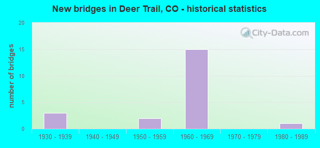
- New bridges - historical statistics
- 31930-1939
- 21950-1959
- 151960-1969
- 11980-1989

- Reconstructed bridges - Historical Statistics
- 11990-1999
- 02000-2009
- 02010-2019
- 12020-2022


- Bridge Condition - Deck
- 13.3%Very good
- 13.3%Good
- 46.7%Satisfactory
- 13.3%Fair
- 13.3%Poor

- Bridge Condition - Superstructure
- 6.7%Very good
- 6.7%Good
- 46.7%Satisfactory
- 26.7%Fair
- 13.3%Poor

- Bridge Condition - Substructure
- 6.7%Good
- 53.3%Satisfactory
- 33.3%Fair
- 6.7%Poor

- Bridge Condition - Channel
- 64.3%Very good
- 21.4%Good
- 14.3%Satisfactory
Find on map >> Show street view
Structure Number: ARA 217-6.1, Location: 2.2 MI N OF CR 34 (Lat: 39.654583, Lng: -104.041803), Route carried "on" structure: County highway , Year Built: 1950, Year Reconstructed: 2004, Status: Open, Structure Length: 1.23m (4.04ft), Average Daily Traffic: 174 (year 2021), Truck Traffic: 1%, Average Future Daily Traffic: 212 (year 2041), Design Load: HS 20, Features Intersected: FIRST CREEK, Facility Carried by Structure: COUNTY RD 217
Minimum Vertical Clearance: 30+ m (98+ ft), Kilometerpoint: 3.487, Lanes on structure: 2, Owner: County Highway Agency, Approaching Roadway Width: 7.6m (24.9ft), Skew: 3 degrees, Material/Design: Steel continuous, Design/Construction: Stringer/Multi-beam, Number Of Spans In Main Unit: 2, Length of Maximum Span: 5.9m (19.4ft), Curb-To-Curb Width: 9.8m (32.2ft), Out-to-Out Width: 10.7m (35.1ft)
Condition: Deck: Satisfactory, Superstructure: Satisfactory, Substructure: Satisfactory, Channel: Very good, Inventory Rating: 69.1 metric tons, Method Used To Determine Inventory Rating: Load Factor (LF), Structural Evaluation: Equal to present minimum criteria, Deck Geometry: Better than present minimum criteria, Waterway Adequacy: Equal to present minimum criteria, Approach Roadway Alignment: Equal to present desirable criteria, Designated Inspection Frequency: Every 24 months, Inspection Date: November 2021, Deck Structure Type: Concrete Cast-file-Place, Wearing Surface/Protective System: Wearing Surface: Bituminous, Membrane: Built-up, Deck Protection: Epoxy Coated Reinforcing
Find on map >> Show street view
Structure Number: ARA 34-56.3, Location: 2.5 MI E OF COUNTY RD 217 (Lat: 39.624044, Lng: -103.996511), Route carried "on" structure: County highway , Year Built: 1950, Year Reconstructed: 2020, Status: Open, Structure Length: 1.21m (3.97ft), Average Daily Traffic: 129 (year 2021), Average Future Daily Traffic: 157 (year 2041), Features Intersected: FIRST CREEK, Facility Carried by Structure: COUNTY RD 34
Minimum Vertical Clearance: 30+ m (98+ ft), Kilometerpoint: 3.980, Lanes on structure: 2, Owner: County Highway Agency, Approaching Roadway Width: 10.7m (35.1ft), Material/Design: Steel continuous, Design/Construction: Stringer/Multi-beam, Number Of Spans In Main Unit: 2, Length of Maximum Span: 5.7m (18.7ft), Curb-To-Curb Width: 8.3m (27.2ft), Out-to-Out Width: 9.2m (30.2ft)
Condition: Deck: Very good, Superstructure: Satisfactory, Substructure: Satisfactory, Channel: Good, Operating Rating: 27.5 metric tons, Method Used To Determine Operating Rating: Load and Resistance Factor Rating (LRFR) rating reported by rating factor(RF) method using HL-93 loadings, Inventory Rating: 21.4 metric tons, Method Used To Determine Inventory Rating: Load and Resistance Factor Rating (LRFR) rating reported by rating factor(RF) method using HL-93 loadings, Structural Evaluation: Equal to present minimum criteria, Deck Geometry: Somewhat better than minimum adequacy, Waterway Adequacy: Equal to present desirable criteria, Approach Roadway Alignment: Equal to present minimum criteria, Designated Inspection Frequency: Every 24 months, Inspection Date: November 2021, Deck Structure Type: Concrete Cast-file-Place, Wearing Surface/Protective System: Wearing Surface: Bituminous
Find on map >> Show street view
Structure Number: ARA 38-51.4A, Location: 2.7 MI W OF US 40 (Lat: 39.609117, Lng: -104.092286), Route carried "on" structure: County highway , Year Built: 1987, Status: Open, Structure Length: 4.34m (14.24ft), Average Daily Traffic: 146 (year 2021), Truck Traffic: 1%, Average Future Daily Traffic: 179 (year 2041), Design Load: HS 20, Features Intersected: MIDDLE BIJOU CREEK, Facility Carried by Structure: COUNTY ROAD 38
Minimum Vertical Clearance: 30+ m (98+ ft), Kilometerpoint: 10.247, Lanes on structure: 2, Owner: County Highway Agency, Approaching Roadway Width: 9.8m (32.2ft), Material/Design: Prestressed concrete continuous, Design/Construction: Stringer/Multi-beam, Number Of Spans In Main Unit: 2, Length of Maximum Span: 20.7m (67.9ft), Curb-To-Curb Width: 9.2m (30.2ft), Out-to-Out Width: 9.9m (32.5ft)
Condition: Deck: Very good, Superstructure: Very good, Substructure: Good, Channel: Very good, Operating Rating: 49.4 metric tons, Method Used To Determine Operating Rating: Load Factor (LF), Inventory Rating: 29.7 metric tons, Method Used To Determine Inventory Rating: Load Factor (LF), Structural Evaluation: Better than present minimum criteria, Deck Geometry: Equal to present minimum criteria, Waterway Adequacy: Equal to present desirable criteria, Approach Roadway Alignment: Equal to present desirable criteria, Designated Inspection Frequency: Every 24 months, Inspection Date: November 2021, Deck Structure Type: Concrete Cast-file-Place, Wearing Surface/Protective System: Wearing Surface: Bituminous, Membrane: Built-up
Find on map >> Show street view
Structure Number: ARA 38-53.7, Location: .4 MILE W OF US 40 (Lat: 39.609381, Lng: -104.051353), Route carried "on" structure: County highway , Year Built: 1965, Status: Open, Structure Length: 4.57m (14.99ft), Average Daily Traffic: 315 (year 2021), Truck Traffic: 9%, Average Future Daily Traffic: 385 (year 2041), Design Load: HS 20, Features Intersected: E. BIJOU CREEK, Facility Carried by Structure: COUNTY ROAD 38
Minimum Vertical Clearance: 30+ m (98+ ft), Kilometerpoint: 13.821, Lanes on structure: 2, Owner: County Highway Agency, Approaching Roadway Width: 9.8m (32.2ft), Material/Design: Prestressed concrete, Design/Construction: Tee Beam, Number Of Spans In Main Unit: 5, Length of Maximum Span: 8.9m (29.2ft), Curb-To-Curb Width: 8.3m (27.2ft), Out-to-Out Width: 9.2m (30.2ft)
Condition: Deck: Fair, Superstructure: Fair, Substructure: Satisfactory, Channel: Satisfactory, Operating Rating: 36.2 metric tons, Method Used To Determine Operating Rating: Load Factor (LF), Inventory Rating: 21.7 metric tons, Method Used To Determine Inventory Rating: Load Factor (LF), Structural Evaluation: Somewhat better than minimum adequacy, Deck Geometry: Somewhat better than minimum adequacy, Waterway Adequacy: Equal to present desirable criteria, Approach Roadway Alignment: Equal to present desirable criteria, Designated Inspection Frequency: Every 24 months, Inspection Date: November 2021, Deck Structure Type: Other, Wearing Surface/Protective System: Wearing Surface: Bituminous
Find on map >> Show street view
Structure Number: F-20-BA, Location: 7.8 MI E OF JCT US 36 (Lat: 39.667594, Lng: -104.091931), Route carried "on" structure: Interstate 70A, Year Built: 1965, Status: Open, Structure Length: 2.85m (9.35ft), Average Daily Traffic: 6,000 (year 2020), Truck Traffic: 32%, Average Future Daily Traffic: 7,260 (year 2040), Design Load: HS 20, Features Intersected: US 40 FRONTAGE ROAD, Facility Carried by Structure: I 70 ML EBND
Minimum Vertical Clearance: 30+ m (98+ ft), Kilometerpoint: 521.891, Lanes on structure: 2, Lanes under structure: 2, Base Highway Network: Yes, Owner: State Highway Agency, Approaching Roadway Width: 11.6m (38.1ft), Skew: 10 degrees, Material/Design: Concrete, Design/Construction: Tee Beam, Number Of Spans In Main Unit: 3, Length of Maximum Span: 9.1m (29.9ft), Curb-To-Curb Width: 12.0m (39.4ft), Out-to-Out Width: 12.8m (42.0ft)
Condition: Deck: Good, Superstructure: Satisfactory, Substructure: Poor, Operating Rating: 69.8 metric tons, Method Used To Determine Operating Rating: Load Factor (LF), Inventory Rating: 41.8 metric tons, Method Used To Determine Inventory Rating: Load Factor (LF), Structural Evaluation: Meets minimum limits, Deck Geometry: Equal to present minimum criteria, Underclear: Meets minimum limits, Approach Roadway Alignment: Equal to present desirable criteria, Designated Inspection Frequency: Every 24 months, Inspection Date: June 2021, Deck Structure Type: Concrete Cast-file-Place, Wearing Surface/Protective System: Wearing Surface: Bituminous, Membrane: Built-up
Find on map >> Show street view
Structure Number: F-20-BC, Location: IN DEERTRAIL (Lat: 39.614658, Lng: -104.040808), Route carried "on" structure: Interstate 70A, Year Built: 1965, Status: Open, Structure Length: 3.32m (10.89ft), Average Daily Traffic: 6,000 (year 2020), Truck Traffic: 32%, Average Future Daily Traffic: 7,260 (year 2040), Design Load: HS 20, Features Intersected: I 70 BUSS RT, Facility Carried by Structure: I 70 ML EBND
Minimum Vertical Clearance: 30+ m (98+ ft), Kilometerpoint: 529.300, Lanes on structure: 2, Lanes under structure: 2, Base Highway Network: Yes, Owner: State Highway Agency, Approaching Roadway Width: 11.6m (38.1ft), Skew: 10 degrees, Material/Design: Concrete, Design/Construction: Tee Beam, Number Of Spans In Main Unit: 3, Length of Maximum Span: 10.7m (35.1ft), Curb-To-Curb Width: 12.0m (39.4ft), Out-to-Out Width: 12.8m (42.0ft)
Condition: Deck: Satisfactory, Superstructure: Fair, Substructure: Fair, Operating Rating: 59.2 metric tons, Method Used To Determine Operating Rating: Load Factor (LF), Inventory Rating: 35.5 metric tons, Method Used To Determine Inventory Rating: Load Factor (LF), Structural Evaluation: Somewhat better than minimum adequacy, Deck Geometry: Equal to present minimum criteria, Underclear: Meets minimum limits, Approach Roadway Alignment: Equal to present desirable criteria, Designated Inspection Frequency: Every 24 months, Inspection Date: April 2021, Deck Structure Type: Concrete Cast-file-Place, Wearing Surface/Protective System: Wearing Surface: Integral Concrete
Find on map >> Show street view
Structure Number: F-20-BD, Location: IN DEERTRAIL (Lat: 39.614761, Lng: -104.040517), Route carried "on" structure: Interstate 70A, Year Built: 1965, Status: Open, Structure Length: 3.32m (10.89ft), Average Daily Traffic: 6,000 (year 2020), Truck Traffic: 32%, Average Future Daily Traffic: 7,260 (year 2040), Design Load: HS 20+Mod, Features Intersected: I 70 BUSS RT, Facility Carried by Structure: I 70 ML WBND
Minimum Vertical Clearance: 30+ m (98+ ft), Kilometerpoint: 529.302, Lanes on structure: 2, Lanes under structure: 2, Base Highway Network: Yes, Owner: State Highway Agency, Approaching Roadway Width: 11.6m (38.1ft), Skew: 10 degrees, Material/Design: Concrete, Design/Construction: Tee Beam, Number Of Spans In Main Unit: 3, Length of Maximum Span: 10.7m (35.1ft), Curb-To-Curb Width: 12.0m (39.4ft), Out-to-Out Width: 12.8m (42.0ft)
Condition: Deck: Satisfactory, Superstructure: Good, Substructure: Fair, Operating Rating: 49.9 metric tons, Method Used To Determine Operating Rating: Load Factor (LF), Inventory Rating: 35.6 metric tons, Method Used To Determine Inventory Rating: Load Factor (LF), Structural Evaluation: Somewhat better than minimum adequacy, Deck Geometry: Equal to present minimum criteria, Underclear: Meets minimum limits, Approach Roadway Alignment: Equal to present desirable criteria, Designated Inspection Frequency: Every 24 months, Inspection Date: April 2021, Deck Structure Type: Concrete Cast-file-Place, Wearing Surface/Protective System: Wearing Surface: Integral Concrete, Deck Protection: Epoxy Coated Reinforcing
Find on map >> Show street view
Structure Number: F-20-BE, Location: 1.4 MI E OF JCT DEERTRAIL (Lat: 39.595225, Lng: -104.033394), Route carried "on" structure: Interstate 70A, Year Built: 1965, Status: Open, Structure Length: 4.11m (13.48ft), Average Daily Traffic: 5,500 (year 2020), Truck Traffic: 32%, Average Future Daily Traffic: 7,040 (year 2040), Design Load: HS 20+Mod, Features Intersected: US 40 ML, DITCH, Facility Carried by Structure: I 70 ML EBND
Minimum Vertical Clearance: 30+ m (98+ ft), Kilometerpoint: 531.560, Lanes on structure: 2, Lanes under structure: 2, Base Highway Network: Yes, Owner: State Highway Agency, Approaching Roadway Width: 11.6m (38.1ft), Skew: 11 degrees, Material/Design: Concrete, Design/Construction: Tee Beam, Number Of Spans In Main Unit: 4, Length of Maximum Span: 10.2m (33.5ft), Curb-To-Curb Width: 12.0m (39.4ft), Out-to-Out Width: 12.8m (42.0ft)
Condition: Deck: Satisfactory, Superstructure: Fair, Substructure: Fair, Channel: Very good, Operating Rating: 54.5 metric tons, Method Used To Determine Operating Rating: Load Factor (LF), Inventory Rating: 32.7 metric tons, Method Used To Determine Inventory Rating: Load Factor (LF), Structural Evaluation: Somewhat better than minimum adequacy, Deck Geometry: Equal to present minimum criteria, Underclear: Meets minimum limits, Waterway Adequacy: Equal to present desirable criteria, Approach Roadway Alignment: Equal to present desirable criteria, Designated Inspection Frequency: Every 24 months, Inspection Date: April 2021, Deck Structure Type: Concrete Cast-file-Place, Wearing Surface/Protective System: Wearing Surface: Other, Membrane: Other
Find on map >> Show street view
Structure Number: F-20-BF, Location: 2.6 MI W OF ELBERT CL (Lat: 39.595222, Lng: -104.032906), Route carried "on" structure: Interstate 70A, Year Built: 1965, Status: Open, Structure Length: 4.11m (13.48ft), Average Daily Traffic: 5,500 (year 2020), Truck Traffic: 32%, Average Future Daily Traffic: 7,040 (year 2040), Design Load: HS 20+Mod, Features Intersected: CR 42, DITCH, Facility Carried by Structure: I 70 ML WBND
Minimum Vertical Clearance: 30+ m (98+ ft), Kilometerpoint: 531.573, Lanes on structure: 2, Lanes under structure: 2, Base Highway Network: Yes, Owner: State Highway Agency, Approaching Roadway Width: 11.6m (38.1ft), Skew: 11 degrees, Material/Design: Concrete, Design/Construction: Tee Beam, Number Of Spans In Main Unit: 4, Length of Maximum Span: 10.1m (33.1ft), Curb-To-Curb Width: 12.0m (39.4ft), Out-to-Out Width: 12.8m (42.0ft)
Condition: Deck: Satisfactory, Superstructure: Fair, Substructure: Fair, Channel: Very good, Operating Rating: 33.8 metric tons, Method Used To Determine Operating Rating: Load Factor (LF), Inventory Rating: 20.3 metric tons, Method Used To Determine Inventory Rating: Load Factor (LF), Structural Evaluation: Somewhat better than minimum adequacy, Deck Geometry: Equal to present minimum criteria, Underclear: High priority of corrective action, Waterway Adequacy: Equal to present desirable criteria, Approach Roadway Alignment: Equal to present desirable criteria, Designated Inspection Frequency: Every 24 months, Inspection Date: April 2021, Deck Structure Type: Concrete Cast-file-Place, Wearing Surface/Protective System: Wearing Surface: Other, Membrane: Other
Find on map >> Show street view
Structure Number: F-20-BN, Location: IN DEERTRAIL (Lat: 39.611983, Lng: -104.039136), Route carried "on" structure: Interstate 70A, Year Built: 1965, Status: Open, Structure Length: 0.73m (2.40ft), Average Daily Traffic: 11,000 (year 2020), Truck Traffic: 32%, Average Future Daily Traffic: 14,080 (year 2040), Design Load: H 20, Features Intersected: DRAW, Facility Carried by Structure: I 70 ML
Minimum Vertical Clearance: 30+ m (98+ ft), Kilometerpoint: 529.630, Lanes on structure: 6, Base Highway Network: Yes, Owner: State Highway Agency, Approaching Roadway Width: 31.4m (103.0ft), Skew: 23 degrees, Material/Design: Concrete, Design/Construction: Culvert, Number Of Spans In Main Unit: 2, Length of Maximum Span: 3.5m (11.5ft), Out-to-Out Width: 60.7m (199.1ft)
Condition: Channel: Good, Culverts: Satisfactory, Operating Rating: 36.3 metric tons, Method Used To Determine Operating Rating: Field evaluation and documented engineering judgment, Inventory Rating: 32.7 metric tons, Method Used To Determine Inventory Rating: Field evaluation and documented engineering judgment, Structural Evaluation: Equal to present minimum criteria, Waterway Adequacy: Equal to present desirable criteria, Approach Roadway Alignment: Equal to present desirable criteria, Designated Inspection Frequency: Every 24 months, Inspection Date: April 2021
Find on map >> Show street view
Structure Number: F-20-BP, Location: IN DEERTRAIL (Lat: 39.614236, Lng: -104.041294), Route carried "on" structure: Spur State highway 70N, Year Built: 1965, Status: Open, Structure Length: 1.01m (3.31ft), Average Daily Traffic: 940 (year 2020), Truck Traffic: 8%, Average Future Daily Traffic: 1,043 (year 2040), Design Load: HS 20, Features Intersected: DRAW, Facility Carried by Structure: I 70 DEERTRAIL SPU
Minimum Vertical Clearance: 30+ m (98+ ft), Kilometerpoint: 0.423, Lanes on structure: 2, Owner: State Highway Agency, Approaching Roadway Width: 11.0m (36.1ft), Material/Design: Concrete, Design/Construction: Culvert, Number Of Spans In Main Unit: 3, Length of Maximum Span: 3.0m (9.8ft), Curb-To-Curb Width: 10.4m (34.1ft), Out-to-Out Width: 11.0m (36.1ft)
Condition: Channel: Very good, Culverts: Satisfactory, Operating Rating: 36.3 metric tons, Method Used To Determine Operating Rating: Field evaluation and documented engineering judgment, Inventory Rating: 32.7 metric tons, Method Used To Determine Inventory Rating: Field evaluation and documented engineering judgment, Structural Evaluation: Equal to present minimum criteria, Deck Geometry: Equal to present minimum criteria, Waterway Adequacy: Equal to present desirable criteria, Approach Roadway Alignment: Equal to present desirable criteria, Designated Inspection Frequency: Every 24 months, Inspection Date: April 2021
Find on map >> Show street view
Structure Number: F-20-BQ, Location: 5 MI E OF DEER TRAIL (Lat: 39.549508, Lng: -104.002528), Route carried "on" structure: Interstate 70A, Year Built: 1966, Status: Open, Structure Length: 4.27m (14.01ft), Average Daily Traffic: 5,500 (year 2020), Truck Traffic: 32%, Average Future Daily Traffic: 7,040 (year 2040), Design Load: HS 20+Mod, Features Intersected: COUNTY ROAD 190, DRAW, Facility Carried by Structure: I 70 ML WBND
Minimum Vertical Clearance: 30+ m (98+ ft), Kilometerpoint: 537.300, Lanes on structure: 2, Lanes under structure: 2, Base Highway Network: Yes, Owner: State Highway Agency, Approaching Roadway Width: 11.6m (38.1ft), Skew: 10 degrees, Material/Design: Concrete, Design/Construction: Tee Beam, Number Of Spans In Main Unit: 4, Length of Maximum Span: 11.3m (37.1ft), Curb-To-Curb Width: 12.0m (39.4ft), Out-to-Out Width: 12.8m (42.0ft)
Condition: Deck: Good, Superstructure: Satisfactory, Substructure: Satisfactory, Channel: Very good, Operating Rating: 56.7 metric tons, Method Used To Determine Operating Rating: Load Factor (LF), Inventory Rating: 33.9 metric tons, Method Used To Determine Inventory Rating: Load Factor (LF), Structural Evaluation: Equal to present minimum criteria, Deck Geometry: Equal to present minimum criteria, Underclear: High priority of corrective action, Waterway Adequacy: Equal to present desirable criteria, Approach Roadway Alignment: Equal to present desirable criteria, Designated Inspection Frequency: Every 24 months, Inspection Date: April 2021, Deck Structure Type: Other, Wearing Surface/Protective System: Wearing Surface: Other, Membrane: Other
Find on map >> Show street view
Structure Number: F-20-BR, Location: 1.1 MI E OF ARAPAHOE CL. (Lat: 39.549333, Lng: -104.002933), Route carried "on" structure: Interstate 70A, Year Built: 1966, Status: Open, Structure Length: 4.27m (14.01ft), Average Daily Traffic: 5,500 (year 2020), Truck Traffic: 32%, Average Future Daily Traffic: 7,040 (year 2040), Design Load: HS 20+Mod, Features Intersected: COUNTY ROAD 190, DRAW, Facility Carried by Structure: I 70 ML EBND
Minimum Vertical Clearance: 30+ m (98+ ft), Kilometerpoint: 537.302, Lanes on structure: 2, Lanes under structure: 2, Base Highway Network: Yes, Owner: State Highway Agency, Approaching Roadway Width: 11.6m (38.1ft), Skew: 10 degrees, Material/Design: Concrete, Design/Construction: Tee Beam, Number Of Spans In Main Unit: 4, Length of Maximum Span: 11.3m (37.1ft), Curb-To-Curb Width: 12.0m (39.4ft), Out-to-Out Width: 12.8m (42.0ft)
Condition: Deck: Satisfactory, Superstructure: Satisfactory, Substructure: Satisfactory, Channel: Very good, Operating Rating: 56.7 metric tons, Method Used To Determine Operating Rating: Load Factor (LF), Inventory Rating: 33.9 metric tons, Method Used To Determine Inventory Rating: Load Factor (LF), Structural Evaluation: Equal to present minimum criteria, Deck Geometry: Equal to present minimum criteria, Underclear: Meets minimum limits, Waterway Adequacy: Equal to present desirable criteria, Approach Roadway Alignment: Equal to present desirable criteria, Designated Inspection Frequency: Every 24 months, Inspection Date: April 2021, Deck Structure Type: Other, Wearing Surface/Protective System: Wearing Surface: Other, Membrane: Other
Find on map >> Show street view
Structure Number: F-20-E, Location: 5 MI E OF JCT DEERTRAIL S (Lat: 39.549131, Lng: -104.003122), Route carried "on" structure: ServiceInterstate 70A, Year Built: 1939, Status: Open, Structure Length: 1.40m (4.59ft), Average Daily Traffic: 11,000 (year 2020), Truck Traffic: 32%, Average Future Daily Traffic: 14,080 (year 2040), Design Load: H 15, Features Intersected: DRAW SR, Facility Carried by Structure: I 70 SERVICE RD
Minimum Vertical Clearance: 30+ m (98+ ft), Kilometerpoint: 5.732, Lanes on structure: 2, Owner: State Highway Agency, Approaching Roadway Width: 7.3m (24.0ft), Skew: 4 degrees, Material/Design: Wood or Timber, Design/Construction: Stringer/Multi-beam, Number Of Spans In Main Unit: 2, Length of Maximum Span: 6.7m (22.0ft), Curb or Sidewalk Widths: Left: 0.2m (0.7ft), Right: 0.2m (0.7ft), Curb-To-Curb Width: 9.4m (30.8ft), Out-to-Out Width: 9.8m (32.2ft)
Condition: Deck: Satisfactory, Superstructure: Satisfactory, Substructure: Fair, Channel: Satisfactory, Operating Rating: 33.0 metric tons, Method Used To Determine Operating Rating: Allowable Stress (AS), Inventory Rating: 21.4 metric tons, Method Used To Determine Inventory Rating: Allowable Stress (AS), Structural Evaluation: Somewhat better than minimum adequacy, Deck Geometry: High priority of corrective action, Waterway Adequacy: Equal to present desirable criteria, Approach Roadway Alignment: Equal to present desirable criteria, Designated Inspection Frequency: Every 24 months, Inspection Date: April 2021, Deck Structure Type: Wood or Timber, Wearing Surface/Protective System: Wearing Surface: Bituminous
Find on map >> Show street view
Structure Number: F-20-F, Location: 2.7 MI NW OF DEER TRAIL (Lat: 39.638825, Lng: -104.070600), Route carried "on" structure: US 40E, Year Built: 1966, Status: Open, Structure Length: 15.10m (49.54ft), Average Daily Traffic: 330 (year 2020), Truck Traffic: 15%, Average Future Daily Traffic: 558 (year 2040), Design Load: HS 20+Mod, Features Intersected: EAST BIJOU CREEK, Facility Carried by Structure: US 40 ML
Minimum Vertical Clearance: 30+ m (98+ ft), Kilometerpoint: 3.695, Lanes on structure: 2, Owner: State Highway Agency, Approaching Roadway Width: 7.3m (24.0ft), Skew: 4 degrees, Material/Design: Steel continuous, Design/Construction: Stringer/Multi-beam, Number Of Spans In Main Unit: 6, Length of Maximum Span: 29.3m (96.1ft), Curb-To-Curb Width: 8.5m (27.9ft), Out-to-Out Width: 9.8m (32.2ft)
Condition: Deck: Poor, Superstructure: Poor, Substructure: Satisfactory, Channel: Very good, Operating Rating: 49.9 metric tons, Method Used To Determine Operating Rating: Load Factor (LF), Inventory Rating: 30.0 metric tons, Method Used To Determine Inventory Rating: Load Factor (LF), Structural Evaluation: Meets minimum limits, Deck Geometry: Equal to present minimum criteria, Waterway Adequacy: Equal to present desirable criteria, Approach Roadway Alignment: Equal to present desirable criteria, Designated Inspection Frequency: Every 24 months, Inspection Date: March 2021, Deck Structure Type: Concrete Cast-file-Place, Wearing Surface/Protective System: Wearing Surface: Bituminous
Find on map >> Show street view
Structure Number: F-20-J, Location: 1.5 MI NW OF DEER TRAIL (Lat: 39.627139, Lng: -104.057917), Route carried "on" structure: US 40E, Year Built: 1931, Status: Temporarily open, Structure Length: 1.77m (5.81ft), Average Daily Traffic: 330 (year 2020), Truck Traffic: 15%, Average Future Daily Traffic: 558 (year 2040), Design Load: H 15, Features Intersected: DRAW, Facility Carried by Structure: US 40 ML
Minimum Vertical Clearance: 30+ m (98+ ft), Kilometerpoint: 5.391, Lanes on structure: 2, Owner: State Highway Agency, Approaching Roadway Width: 7.3m (24.0ft), Material/Design: Wood or Timber, Design/Construction: Stringer/Multi-beam, Number Of Spans In Main Unit: 3, Length of Maximum Span: 5.8m (19.0ft), Curb-To-Curb Width: 9.1m (29.9ft), Out-to-Out Width: 9.4m (30.8ft)
Condition: Deck: Poor, Superstructure: Poor, Substructure: Satisfactory, Channel: Good, Operating Rating: 47.0 metric tons, Method Used To Determine Operating Rating: Allowable Stress (AS), Inventory Rating: 32.3 metric tons, Method Used To Determine Inventory Rating: Allowable Stress (AS), Structural Evaluation: Meets minimum limits, Deck Geometry: Equal to present minimum criteria, Waterway Adequacy: Equal to present desirable criteria, Approach Roadway Alignment: Equal to present desirable criteria, Length Of Structure Improvement: 1.80m (5.91ft), Designated Inspection Frequency: Every 12 months, Inspection Date: March 2022, Bridge Improvement Cost: $277,000, Roadway Improvement Cost: $42,000, Total Project Cost: $557,000, Deck Structure Type: Concrete Cast-file-Place, Wearing Surface/Protective System: Wearing Surface: Bituminous
Find on map >> Show street view
Structure Number: F-20-K, Location: 2.4 MI SE OF DEERTRAIL (Lat: 39.596847, Lng: -104.035244), Route carried "on" structure: US 40E, Year Built: 1931, Status: Open, Structure Length: 2.13m (6.99ft), Average Daily Traffic: 300 (year 2020), Truck Traffic: 9%, Average Future Daily Traffic: 486 (year 2040), Design Load: H 15, Features Intersected: DRAW, Facility Carried by Structure: US 40 ML
Minimum Vertical Clearance: 30+ m (98+ ft), Kilometerpoint: 9.296, Lanes on structure: 2, Owner: State Highway Agency, Approaching Roadway Width: 7.6m (24.9ft), Material/Design: Wood or Timber, Design/Construction: Stringer/Multi-beam, Number Of Spans In Main Unit: 3, Length of Maximum Span: 7.0m (23.0ft), Curb-To-Curb Width: 9.1m (29.9ft), Out-to-Out Width: 9.4m (30.8ft)
Condition: Deck: Fair, Superstructure: Satisfactory, Substructure: Satisfactory, Channel: Very good, Operating Rating: 52.3 metric tons, Method Used To Determine Operating Rating: Allowable Stress (AS), Inventory Rating: 36.2 metric tons, Method Used To Determine Inventory Rating: Allowable Stress (AS), Structural Evaluation: Equal to present minimum criteria, Deck Geometry: Equal to present minimum criteria, Waterway Adequacy: Equal to present desirable criteria, Approach Roadway Alignment: Equal to present desirable criteria, Designated Inspection Frequency: Every 24 months, Inspection Date: March 2021, Deck Structure Type: Concrete Cast-file-Place, Wearing Surface/Protective System: Wearing Surface: Bituminous
Find on map >> Show street view
Structure Number: F-20-BC, Location: IN DEERTRAIL (Lat: 39.614658, Lng: -104.040808), Route carried "under" structure: Business State highway 70N, Year Built: 1965, Structure Length: 0. m, Average Daily Traffic: 860 (year 2011), Truck Traffic: 8%, Features Intersected: I 70 BUSS RT, Facility Carried by Structure: I 70 ML EBND
Minimum Vertical Clearance: 5.51m (18.08ft), Kilometerpoint: 0.510, Lanes on structure: 2, Lanes under structure: 2, Material/Design: Concrete, Design/Construction: Tee Beam, Length of Maximum Span: 10.7m (35.1ft)
Find on map >> Show street view
Structure Number: F-20-BD, Location: IN DEERTRAIL (Lat: 39.614761, Lng: -104.040517), Route carried "under" structure: Business State highway 70N, Year Built: 1965, Structure Length: 0. m, Average Daily Traffic: 860 (year 2011), Truck Traffic: 8%, Features Intersected: I 70 BUSS RT, Facility Carried by Structure: I 70 ML WBND
Minimum Vertical Clearance: 5.31m (17.42ft), Kilometerpoint: 0.512, Lanes on structure: 2, Lanes under structure: 2, Material/Design: Concrete, Design/Construction: Tee Beam, Length of Maximum Span: 10.7m (35.1ft)
Find on map >> Show street view
Structure Number: F-20-BE, Location: 1.4 MI E OF JCT DEERTRAIL (Lat: 39.595225, Lng: -104.033394), Route carried "under" structure: US 40E, Year Built: 1965, Structure Length: 0. m, Average Daily Traffic: 160 (year 2011), Truck Traffic: 10%, Features Intersected: US 40 ML, DITCH, Facility Carried by Structure: I 70 ML EBND
Minimum Vertical Clearance: 6.12m (20.08ft), Kilometerpoint: 566.772, Lanes on structure: 2, Lanes under structure: 2, Material/Design: Concrete, Design/Construction: Tee Beam, Length of Maximum Span: 10.2m (33.5ft)
Find on map >> Show street view
Structure Number: F-20-BF, Location: 2.6 MI W OF ELBERT CL (Lat: 39.595222, Lng: -104.032906), Route carried "under" structure: US 40E, Year Built: 1965, Structure Length: 0. m, Average Daily Traffic: 160 (year 2011), Truck Traffic: 10%, Features Intersected: CR 42, DITCH, Facility Carried by Structure: I 70 ML WBND
Minimum Vertical Clearance: 5.13m (16.83ft), Kilometerpoint: 566.773, Lanes on structure: 2, Lanes under structure: 2, Material/Design: Concrete, Design/Construction: Tee Beam, Length of Maximum Span: 10.1m (33.1ft)