Bridge Statistics for De Funiak Springs, Florida (FL)
Condition, Traffic, Stress, Structural Evaluation, Project Costs
- National Bridge Inventory (NBI) Statistics
- 38Number of bridges
- 282ft / 86.2mTotal length
- $813,000Total costs
- 270,689Total average daily traffic
- 55,072Total average daily truck traffic
- National Bridge Inventory (NBI) Registered Bridges for De Funiak Springs
- No street view available for this location
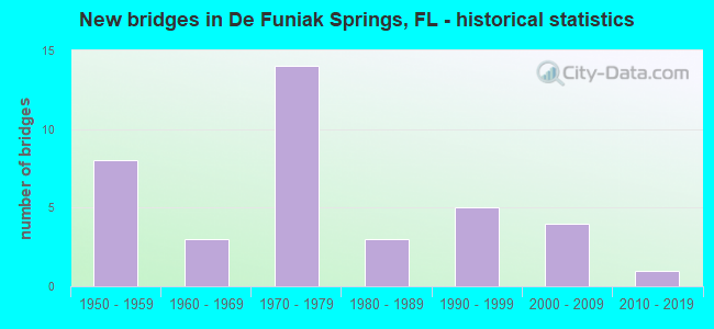
- New bridges - historical statistics
- 81950-1959
- 31960-1969
- 141970-1979
- 31980-1989
- 51990-1999
- 42000-2009
- 12010-2019


- Bridge Condition - Deck
- 5.3%Very good
- 26.3%Good
- 36.8%Satisfactory
- 31.6%Fair

- Bridge Condition - Superstructure
- 42.1%Good
- 21.1%Satisfactory
- 31.6%Fair
- 5.3%Serious

- Bridge Condition - Substructure
- 5.3%Very good
- 52.6%Good
- 26.3%Satisfactory
- 5.3%Fair
- 10.5%Poor

- Bridge Condition - Channel
- 8.3%Excellent
- 8.3%Very good
- 29.2%Good
- 25.0%Satisfactory
- 20.8%Fair
- 8.3%Poor

- Bridge Condition - Culverts
- 9.1%Good
- 54.5%Satisfactory
- 18.2%Fair
- 9.1%Poor
- 9.1%Serious
Find on map >> Show street view
Structure Number: 600003, Location: 0.1mi South of US90 SR10 (Lat: 30.720736, Lng: -86.120883), Route carried "on" structure: City street , Year Built: 1967, Status: Open, Structure Length: 5.64m (18.50ft), Average Daily Traffic: 1,200 (year 2011), Truck Traffic: 5%, Average Future Daily Traffic: 2,226 (year 2035), Design Load: HS 20, Features Intersected: US331 SR83, Facility Carried by Structure: Baldwin Avenue
Minimum Vertical Clearance: 30+ m (98+ ft), Kilometerpoint: 1.502, Lanes on structure: 2, Lanes under structure: 4, Owner: State Highway Agency, Approaching Roadway Width: 7.3m (24.0ft), Skew: 1 degrees, Material/Design: Prestressed concrete, Design/Construction: Stringer/Multi-beam, Number Of Spans In Main Unit: 4, Length of Maximum Span: 16.0m (52.5ft), Curb or Sidewalk Widths: Left: 1.2m (3.9ft), Right: 0.5m (1.6ft), Curb-To-Curb Width: 7.3m (24.0ft), Out-to-Out Width: 9.7m (31.8ft)
Condition: Deck: Good, Superstructure: Good, Substructure: Good, Operating Rating: 65.5 metric tons, Method Used To Determine Operating Rating: Load Factor (LF), Inventory Rating: 42.2 metric tons, Method Used To Determine Inventory Rating: Load Factor (LF), Structural Evaluation: Better than present minimum criteria, Deck Geometry: Meets minimum limits, Underclear: Somewhat better than minimum adequacy, Approach Roadway Alignment: Equal to present desirable criteria, Designated Inspection Frequency: Every 24 months, Inspection Date: January 2021, Deck Structure Type: Concrete Cast-file-Place
Find on map >> Show street view
Structure Number: 600004, Location: 2.7mi W. of SR83 US331 (Lat: 30.706525, Lng: -86.163217), Route carried "on" structure: County highway 280, Year Built: 1972, Status: Open, Structure Length: 12.44m (40.81ft), Average Daily Traffic: 4,000 (year 2020), Truck Traffic: 16%, Average Future Daily Traffic: 6,940 (year 2042), Design Load: HS 20+Mod, Features Intersected: I10 SR8
Minimum Vertical Clearance: 30+ m (98+ ft), Kilometerpoint: 5.840, Lanes on structure: 2, Lanes under structure: 4, Owner: State Highway Agency, Approaching Roadway Width: 7.3m (24.0ft), Skew: 4 degrees, Material/Design: Steel continuous, Design/Construction: Stringer/Multi-beam, Number Of Spans In Main Unit: 2, Number Of Approach Spans: 2, Length of Maximum Span: 41.5m (136.2ft), Curb-To-Curb Width: 13.4m (44.0ft), Out-to-Out Width: 14.1m (46.3ft)
Condition: Deck: Good, Superstructure: Good, Substructure: Good, Operating Rating: 60.8 metric tons, Method Used To Determine Operating Rating: Load Factor (LF), Inventory Rating: 36.3 metric tons, Method Used To Determine Inventory Rating: Load Factor (LF), Structural Evaluation: Better than present minimum criteria, Deck Geometry: Better than present minimum criteria, Underclear: Somewhat better than minimum adequacy, Approach Roadway Alignment: Equal to present desirable criteria, Designated Inspection Frequency: Every 24 months, Inspection Date: September 2021, Deck Structure Type: Concrete Cast-file-Place
Find on map >> Show street view
Structure Number: 600005, Location: 2.1 Miles S. of SR10 US90 (Lat: 30.692239, Lng: -86.122528), Route carried "on" structure: Interstate 10, Year Built: 1972, Status: Open, Structure Length: 6.10m (20.01ft), Average Daily Traffic: 9,986 (year 2020), Truck Traffic: 29%, Average Future Daily Traffic: 17,325 (year 2042), Design Load: HS 20+Mod, Features Intersected: US331 SR83
Minimum Vertical Clearance: 30+ m (98+ ft), Kilometerpoint: 28.262, Lanes on structure: 2, Lanes under structure: 4, Base Highway Network: Yes, Owner: State Highway Agency, Approaching Roadway Width: 11.6m (38.1ft), Material/Design: Prestressed concrete, Design/Construction: Stringer/Multi-beam, Number Of Spans In Main Unit: 2, Length of Maximum Span: 30.5m (100.1ft), Curb-To-Curb Width: 12.2m (40.0ft), Out-to-Out Width: 12.9m (42.3ft)
Condition: Deck: Satisfactory, Superstructure: Satisfactory, Substructure: Good, Inventory Rating: 66.2 metric tons, Method Used To Determine Inventory Rating: Load Factor (LF), Structural Evaluation: Equal to present minimum criteria, Deck Geometry: Better than present minimum criteria, Underclear: Somewhat better than minimum adequacy, Approach Roadway Alignment: Equal to present desirable criteria, Designated Inspection Frequency: Every 24 months, Inspection Date: July 2021, Deck Structure Type: Concrete Cast-file-Place
Find on map >> Show street view
Structure Number: 600006, Location: 1.6mi. E. of US331 SR83 (Lat: 30.691078, Lng: -86.095350), Route carried "on" structure: County highway 280A, Year Built: 1974, Status: Open, Structure Length: 7.91m (25.95ft), Average Daily Traffic: 800 (year 2020), Truck Traffic: 10%, Average Future Daily Traffic: 1,388 (year 2042), Design Load: HS 20+Mod, Features Intersected: I10 SR8
Minimum Vertical Clearance: 30+ m (98+ ft), Kilometerpoint: 4.744, Lanes on structure: 2, Lanes under structure: 4, Owner: State Highway Agency, Approaching Roadway Width: 7.3m (24.0ft), Material/Design: Prestressed concrete, Design/Construction: Stringer/Multi-beam, Number Of Spans In Main Unit: 4, Length of Maximum Span: 26.7m (87.6ft), Curb-To-Curb Width: 13.4m (44.0ft), Out-to-Out Width: 14.1m (46.3ft)
Condition: Deck: Good, Superstructure: Good, Substructure: Good, Operating Rating: 72.6 metric tons, Method Used To Determine Operating Rating: Load Factor (LF), Inventory Rating: 43.5 metric tons, Method Used To Determine Inventory Rating: Load Factor (LF), Structural Evaluation: Better than present minimum criteria, Deck Geometry: Superior to present desirable criteria, Underclear: Somewhat better than minimum adequacy, Approach Roadway Alignment: Equal to present desirable criteria, Designated Inspection Frequency: Every 24 months, Inspection Date: September 2021, Deck Structure Type: Concrete Cast-file-Place
Find on map >> Show street view
Structure Number: 600007, Location: 3.0mi. East of US331 (Lat: 30.691086, Lng: -86.072875), Route carried "on" structure: County highway 280, Year Built: 1974, Status: Open, Structure Length: 10.19m (33.43ft), Average Daily Traffic: 800 (year 2020), Truck Traffic: 16%, Average Future Daily Traffic: 1,388 (year 2042), Design Load: HS 20+Mod, Features Intersected: I10 SR8
Minimum Vertical Clearance: 30+ m (98+ ft), Kilometerpoint: 18.213, Lanes on structure: 2, Lanes under structure: 4, Owner: State Highway Agency, Approaching Roadway Width: 7.3m (24.0ft), Skew: 2 degrees, Material/Design: Prestressed concrete, Design/Construction: Stringer/Multi-beam, Number Of Spans In Main Unit: 4, Length of Maximum Span: 29.2m (95.8ft), Curb-To-Curb Width: 13.4m (44.0ft), Out-to-Out Width: 14.1m (46.3ft)
Condition: Deck: Good, Superstructure: Good, Substructure: Good, Operating Rating: 75.3 metric tons, Method Used To Determine Operating Rating: Load Factor (LF), Inventory Rating: 44.5 metric tons, Method Used To Determine Inventory Rating: Load Factor (LF), Structural Evaluation: Better than present minimum criteria, Deck Geometry: Superior to present desirable criteria, Underclear: Somewhat better than minimum adequacy, Approach Roadway Alignment: Equal to present desirable criteria, Designated Inspection Frequency: Every 24 months, Inspection Date: September 2021, Deck Structure Type: Concrete Cast-file-Place
Find on map >> Show street view
Structure Number: 600016, Location: 2.4 Mi South of I 10 (Lat: 30.648481, Lng: -86.055747), Route carried "on" structure: County highway 280, Year Built: 1954, Status: Open, Structure Length: 0.97m (3.18ft), Average Daily Traffic: 750 (year 2020), Truck Traffic: 10%, Average Future Daily Traffic: 1,301 (year 2042), Design Load: HS 20, Features Intersected: Panther Creek
Minimum Vertical Clearance: 30+ m (98+ ft), Kilometerpoint: 23.554, Lanes on structure: 2, Owner: County Highway Agency, Approaching Roadway Width: 6.7m (22.0ft), Material/Design: Concrete, Design/Construction: Culvert, Number Of Spans In Main Unit: 3, Length of Maximum Span: 3.3m (10.8ft)
Condition: Channel: Fair, Culverts: Satisfactory, Operating Rating: 55.3 metric tons, Method Used To Determine Operating Rating: Load Factor (LF), Inventory Rating: 32.7 metric tons, Method Used To Determine Inventory Rating: Load Factor (LF), Structural Evaluation: Equal to present minimum criteria, Waterway Adequacy: Better than present minimum criteria, Approach Roadway Alignment: Equal to present desirable criteria, Designated Inspection Frequency: Every 24 months, Underwater Inspection Frequency: Every 24 months, Inspection Date: July 2020, Underwater Inspection Date: July 2020
Find on map >> Show street view
Structure Number: 600017, Location: 1.04 Mi N of McCall Dairy (Lat: 30.699028, Lng: -86.081222), Route carried "on" structure: County highway 280, Year Built: 1954, Status: Open, Structure Length: 1.34m (4.40ft), Average Daily Traffic: 800 (year 2020), Truck Traffic: 16%, Average Future Daily Traffic: 1,388 (year 2042), Design Load: HS 20, Features Intersected: Bruce Creek
Minimum Vertical Clearance: 30+ m (98+ ft), Kilometerpoint: 17.117, Lanes on structure: 2, Owner: County Highway Agency, Approaching Roadway Width: 6.9m (22.6ft), Material/Design: Concrete, Design/Construction: Culvert, Number Of Spans In Main Unit: 4, Length of Maximum Span: 3.4m (11.2ft)
Condition: Channel: Poor, Culverts: Serious, Operating Rating: 61.7 metric tons, Method Used To Determine Operating Rating: Load Factor (LF), Inventory Rating: 36.3 metric tons, Method Used To Determine Inventory Rating: Load Factor (LF), Structural Evaluation: High priority of corrective action, Waterway Adequacy: Better than present minimum criteria, Approach Roadway Alignment: Equal to present desirable criteria, Designated Inspection Frequency: Every 24 months, Underwater Inspection Frequency: Every 6 months, Other Special Inspection Frequency: Every 6 months, Inspection Date: April 2020, Underwater Inspection Date: October 2021, Other Special Inspection Date: October 2021
Find on map >> Show street view
Structure Number: 600057, Location: 2.1 Miles S. of US90 SR10 (Lat: 30.691994, Lng: -86.122514), Route carried "on" structure: Interstate 10, Year Built: 1972, Status: Open, Structure Length: 6.10m (20.01ft), Average Daily Traffic: 9,986 (year 2020), Truck Traffic: 29%, Average Future Daily Traffic: 17,325 (year 2042), Design Load: HS 20+Mod, Features Intersected: US331 SR83
Minimum Vertical Clearance: 30+ m (98+ ft), Kilometerpoint: 28.262, Lanes on structure: 2, Lanes under structure: 4, Base Highway Network: Yes, Owner: State Highway Agency, Approaching Roadway Width: 11.6m (38.1ft), Material/Design: Prestressed concrete, Design/Construction: Stringer/Multi-beam, Number Of Spans In Main Unit: 2, Length of Maximum Span: 30.5m (100.1ft), Curb-To-Curb Width: 12.2m (40.0ft), Out-to-Out Width: 12.9m (42.3ft)
Condition: Deck: Satisfactory, Superstructure: Good, Substructure: Good, Inventory Rating: 66.2 metric tons, Method Used To Determine Inventory Rating: Load Factor (LF), Structural Evaluation: Better than present minimum criteria, Deck Geometry: Better than present minimum criteria, Underclear: Somewhat better than minimum adequacy, Approach Roadway Alignment: Equal to present desirable criteria, Designated Inspection Frequency: Every 24 months, Inspection Date: July 2021, Deck Structure Type: Concrete Cast-file-Place
Find on map >> Show street view
Structure Number: 600058, Location: 1.69Mi West of US 331 (Lat: 30.706222, Lng: -86.151361), Route carried "on" structure: County highway 280, Year Built: 1954, Status: Open, Structure Length: 0.98m (3.22ft), Average Daily Traffic: 4,300 (year 2020), Truck Traffic: 10%, Average Future Daily Traffic: 7,461 (year 2042), Features Intersected: Steep Head Branch, Facility Carried by Structure: Bob Sikes Road
Minimum Vertical Clearance: 30+ m (98+ ft), Kilometerpoint: 7.089, Lanes on structure: 2, Owner: County Highway Agency, Approaching Roadway Width: 7.3m (24.0ft), Material/Design: Steel, Design/Construction: Culvert, Number Of Spans In Main Unit: 3, Length of Maximum Span: 3.7m (12.1ft)
Condition: Channel: Fair, Culverts: Fair, Structural Evaluation: Somewhat better than minimum adequacy, Waterway Adequacy: Better than present minimum criteria, Approach Roadway Alignment: Equal to present desirable criteria, Designated Inspection Frequency: Every 24 months, Inspection Date: May 2020
Find on map >> Show street view
Structure Number: 60006, Location: 1.5 Mi West of SR 83 (Lat: 30.706214, Lng: -86.147486), Route carried "on" structure: County highway 280, Year Built: 1954, Status: Open, Structure Length: 0.83m (2.72ft), Average Daily Traffic: 4,000 (year 2021), Truck Traffic: 16%, Average Future Daily Traffic: 6,940 (year 2042), Design Load: HL 93, Features Intersected: Stage Stand Branch, Facility Carried by Structure: Bob Sikes Road
Minimum Vertical Clearance: 30+ m (98+ ft), Kilometerpoint: 7.413, Lanes on structure: 2, Owner: County Highway Agency, Approaching Roadway Width: 7.3m (24.0ft), Material/Design: Steel, Design/Construction: Culvert, Number Of Spans In Main Unit: 2, Length of Maximum Span: 4.1m (13.5ft)
Condition: Channel: Satisfactory, Culverts: Satisfactory, Structural Evaluation: Equal to present minimum criteria, Waterway Adequacy: Better than present minimum criteria, Approach Roadway Alignment: Equal to present desirable criteria, Designated Inspection Frequency: Every 24 months, Inspection Date: April 2020
Find on map >> Show street view
Structure Number: 600065, Location: 1.9 Mi. E of US331 SR83 (Lat: 30.691056, Lng: -86.090083), Route carried "on" structure: Interstate 10, Year Built: 1974, Status: Open, Structure Length: 1.45m (4.76ft), Average Daily Traffic: 19,971 (year 2020), Truck Traffic: 29%, Average Future Daily Traffic: 34,650 (year 2042), Design Load: HS 20, Features Intersected: Bruce Creek
Minimum Vertical Clearance: 30+ m (98+ ft), Kilometerpoint: 31.403, Lanes on structure: 4, Base Highway Network: Yes, Owner: State Highway Agency, Approaching Roadway Width: 23.2m (76.1ft), Skew: 11 degrees, Material/Design: Concrete, Design/Construction: Culvert, Number Of Spans In Main Unit: 4, Length of Maximum Span: 3.4m (11.2ft)
Condition: Channel: Good, Culverts: Satisfactory, Operating Rating: 58.6 metric tons, Method Used To Determine Operating Rating: Load Factor (LF), Inventory Rating: 35.1 metric tons, Method Used To Determine Inventory Rating: Load Factor (LF), Structural Evaluation: Equal to present minimum criteria, Waterway Adequacy: Equal to present desirable criteria, Approach Roadway Alignment: Equal to present desirable criteria, Designated Inspection Frequency: Every 24 months, Inspection Date: March 2021
Find on map >> Show street view
Structure Number: 600067, Location: 0.1 Mi N of McCall Dairy (Lat: 30.688389, Lng: -86.094306), Route carried "on" structure: County highway 280A, Year Built: 1956, Status: Open, Structure Length: 1.98m (6.50ft), Average Daily Traffic: 800 (year 2021), Truck Traffic: 10%, Average Future Daily Traffic: 1,388 (year 2042), Features Intersected: Bruce Creek
Minimum Vertical Clearance: 30+ m (98+ ft), Kilometerpoint: 4.431, Lanes on structure: 2, Owner: County Highway Agency, Approaching Roadway Width: 5.8m (19.0ft), Material/Design: Concrete, Design/Construction: Culvert, Number Of Spans In Main Unit: 6, Length of Maximum Span: 3.4m (11.2ft)
Condition: Channel: Poor, Culverts: Poor, Operating Rating: 48.8 metric tons, Method Used To Determine Operating Rating: Load Factor (LF), Inventory Rating: 29.3 metric tons, Method Used To Determine Inventory Rating: Load Factor (LF), Structural Evaluation: Meets minimum limits, Waterway Adequacy: Better than present minimum criteria, Approach Roadway Alignment: Equal to present desirable criteria, Length Of Structure Improvement: 2.18m (7.15ft), Designated Inspection Frequency: Every 24 months, Underwater Inspection Frequency: Every 12 months, Other Special Inspection Frequency: Every 12 months, Inspection Date: September 2020, Underwater Inspection Date: September 2021, Other Special Inspection Date: September 2021, Total Project Cost: $813,000
Find on map >> Show street view
Structure Number: 600086, Location: 0.97 Mi N of Goodwin Rd (Lat: 30.740622, Lng: -86.071536), Route carried "on" structure: County highway 183, Year Built: 1955, Status: Open, Structure Length: 0.63m (2.07ft), Average Daily Traffic: 750 (year 2020), Truck Traffic: 16%, Average Future Daily Traffic: 1,301 (year 2042), Design Load: HS 20, Features Intersected: Bridge Creek
Minimum Vertical Clearance: 30+ m (98+ ft), Kilometerpoint: 1.495, Lanes on structure: 2, Owner: County Highway Agency, Approaching Roadway Width: 7.3m (24.0ft), Material/Design: Concrete, Design/Construction: Culvert, Number Of Spans In Main Unit: 2, Length of Maximum Span: 3.1m (10.2ft)
Condition: Channel: Good, Culverts: Satisfactory, Operating Rating: 59.0 metric tons, Method Used To Determine Operating Rating: Load Factor (LF), Inventory Rating: 35.4 metric tons, Method Used To Determine Inventory Rating: Load Factor (LF), Structural Evaluation: Equal to present minimum criteria, Waterway Adequacy: Better than present minimum criteria, Approach Roadway Alignment: Equal to present desirable criteria, Designated Inspection Frequency: Every 24 months, Underwater Inspection Frequency: Every 24 months, Inspection Date: April 2021, Underwater Inspection Date: April 2021
Find on map >> Show street view
Structure Number: 60009, Location: 0.95 Mi North of US 90 (Lat: 30.777836, Lng: -86.070217), Route carried "on" structure: County highway 183, Year Built: 1955, Status: Open, Structure Length: 1.55m (5.09ft), Average Daily Traffic: 650 (year 2019), Truck Traffic: 10%, Average Future Daily Traffic: 1,128 (year 2041), Design Load: HS 20, Features Intersected: Sandy Creek
Minimum Vertical Clearance: 30+ m (98+ ft), Kilometerpoint: 5.676, Lanes on structure: 2, Owner: County Highway Agency, Approaching Roadway Width: 7.3m (24.0ft), Material/Design: Concrete, Design/Construction: Culvert, Number Of Spans In Main Unit: 4, Length of Maximum Span: 4.0m (13.1ft)
Condition: Channel: Satisfactory, Culverts: Satisfactory, Operating Rating: 71.7 metric tons, Method Used To Determine Operating Rating: Load Factor (LF), Inventory Rating: 42.6 metric tons, Method Used To Determine Inventory Rating: Load Factor (LF), Structural Evaluation: Equal to present minimum criteria, Waterway Adequacy: Better than present minimum criteria, Approach Roadway Alignment: Equal to present desirable criteria, Designated Inspection Frequency: Every 24 months, Inspection Date: April 2020
Find on map >> Show street view
Structure Number: 600112, Location: 1.0 MI North of US90 (Lat: 30.736778, Lng: -86.115056), Route carried "on" structure: State highway 83, Year Built: 1953, Status: Open, Structure Length: 1.12m (3.67ft), Average Daily Traffic: 9,500 (year 2020), Truck Traffic: 9%, Average Future Daily Traffic: 16,482 (year 2042), Design Load: HS 20+Mod, Features Intersected: West Sandy Creek
Minimum Vertical Clearance: 30+ m (98+ ft), Kilometerpoint: 1.717, Lanes on structure: 2, Owner: State Highway Agency, Approaching Roadway Width: 9.8m (32.2ft), Material/Design: Steel, Design/Construction: Culvert, Number Of Spans In Main Unit: 3, Length of Maximum Span: 3.0m (9.8ft)
Condition: Channel: Very good, Culverts: Good, Structural Evaluation: Better than present minimum criteria, Waterway Adequacy: Better than present minimum criteria, Approach Roadway Alignment: Equal to present desirable criteria, Designated Inspection Frequency: Every 24 months, Underwater Inspection Frequency: Every 24 months, Inspection Date: December 2021, Underwater Inspection Date: December 2021
Find on map >> Show street view
Structure Number: 600212, Location: 2.7 mi West of SR83 (Lat: 30.705556, Lng: -86.161917), Route carried "on" structure: Interstate 10, Year Built: 1974, Status: Open, Structure Length: 0.64m (2.10ft), Average Daily Traffic: 22,621 (year 2020), Truck Traffic: 29%, Average Future Daily Traffic: 39,247 (year 2042), Design Load: HS 20, Features Intersected: Kiser Branch
Minimum Vertical Clearance: 30+ m (98+ ft), Kilometerpoint: 24.060, Lanes on structure: 4, Base Highway Network: Yes, Owner: State Highway Agency, Approaching Roadway Width: 23.2m (76.1ft), Skew: 24 degrees, Material/Design: Concrete, Design/Construction: Culvert, Number Of Spans In Main Unit: 2, Length of Maximum Span: 3.0m (9.8ft)
Condition: Channel: Good, Culverts: Satisfactory, Inventory Rating: 61.9 metric tons, Method Used To Determine Inventory Rating: Load Factor (LF), Structural Evaluation: Equal to present minimum criteria, Waterway Adequacy: Equal to present desirable criteria, Approach Roadway Alignment: Equal to present desirable criteria, Designated Inspection Frequency: Every 24 months, Inspection Date: May 2021
Find on map >> Show street view
Structure Number: 600221, Location: 2.1 miles N. of US90 (Lat: 30.752939, Lng: -86.113783), Route carried "on" structure: State highway 83, Year Built: 2015, Status: Open, Structure Length: 4.02m (13.19ft), Average Daily Traffic: 7,700 (year 2020), Truck Traffic: 9%, Average Future Daily Traffic: 13,360 (year 2042), Design Load: HL 93, Features Intersected: Juniper Creek
Minimum Vertical Clearance: 30+ m (98+ ft), Kilometerpoint: 3.494, Lanes on structure: 2, Base Highway Network: Yes, Owner: State Highway Agency, Approaching Roadway Width: 9.8m (32.2ft), Material/Design: Prestressed concrete, Design/Construction: Stringer/Multi-beam, Number Of Spans In Main Unit: 1, Length of Maximum Span: 40.2m (131.9ft), Curb-To-Curb Width: 13.4m (44.0ft), Out-to-Out Width: 14.4m (47.2ft)
Condition: Deck: Very good, Superstructure: Good, Substructure: Very good, Channel: Very good, Operating Rating: 36.3 metric tons, Method Used To Determine Operating Rating: Load and Resistance Factor (LRFR), Inventory Rating: 33.6 metric tons, Method Used To Determine Inventory Rating: Load and Resistance Factor (LRFR), Structural Evaluation: Better than present minimum criteria, Deck Geometry: Superior to present desirable criteria, Approach Roadway Alignment: Equal to present desirable criteria, Designated Inspection Frequency: Every 24 months, Inspection Date: September 2021, Deck Structure Type: Concrete Cast-file-Place
Find on map >> Show street view
Structure Number: 604004, Location: 2 Mi East of SR 83 (Lat: 30.642817, Lng: -86.083033), Route carried "on" structure: County highway , Year Built: 1985, Status: Posted for load, Structure Length: 1.37m (4.49ft), Average Daily Traffic: 100 (year 2021), Average Future Daily Traffic: 174 (year 2042), Features Intersected: Bruce Creek, Facility Carried by Structure: E Indian Ck Ran Rd
Minimum Vertical Clearance: 30+ m (98+ ft), Kilometerpoint: 3.166, Lanes on structure: 1, Owner: County Highway Agency, Approaching Roadway Width: 4.6m (15.1ft), Material/Design: Wood or Timber, Design/Construction: Stringer/Multi-beam, Number Of Spans In Main Unit: 4, Length of Maximum Span: 3.7m (12.1ft), Curb or Sidewalk Widths: Left: 0.1m (0.3ft), Right: 0.1m (0.3ft), Curb-To-Curb Width: 4.6m (15.1ft), Out-to-Out Width: 4.9m (16.1ft)
Condition: Deck: Good, Superstructure: Fair, Substructure: Poor, Channel: Satisfactory, Operating Rating: 20.9 metric tons, Method Used To Determine Operating Rating: Allowable Stress (AS), Inventory Rating: 15.4 metric tons, Method Used To Determine Inventory Rating: Allowable Stress (AS), Structural Evaluation: Meets minimum limits, Deck Geometry: Better than present minimum criteria, Waterway Adequacy: Equal to present minimum criteria, Approach Roadway Alignment: Equal to present minimum criteria, Bridge Posting: Required (Relationship of Operating Rating to Maximum Legal Load: 30.0 - 39.9% below), Designated Inspection Frequency: Every 24 months, Other Special Inspection Frequency: Every 12 months, Inspection Date: January 2022, Other Special Inspection Date: January 2022, Deck Structure Type: Wood or Timber, Wearing Surface/Protective System: Wearing Surface: Wood or Timber
Find on map >> Show street view
Structure Number: 604016, Location: 0.7Mi E of Pleasant Ridge (Lat: 30.691939, Lng: -86.162967), Route carried "on" structure: County highway , Year Built: 1985, Status: Posted for load, Structure Length: 0.79m (2.59ft), Average Daily Traffic: 100 (year 2021), Average Future Daily Traffic: 174 (year 2042), Features Intersected: Unnamed Branch, Facility Carried by Structure: Chesser Road
Minimum Vertical Clearance: 30+ m (98+ ft), Kilometerpoint: 1.083, Lanes on structure: 2, Owner: County Highway Agency, Approaching Roadway Width: 6.4m (21.0ft), Material/Design: Wood or Timber, Design/Construction: Stringer/Multi-beam, Number Of Spans In Main Unit: 2, Length of Maximum Span: 4.0m (13.1ft), Curb-To-Curb Width: 8.0m (26.2ft), Out-to-Out Width: 8.1m (26.6ft)
Condition: Deck: Fair, Superstructure: Serious, Substructure: Poor, Channel: Satisfactory, Operating Rating: 9.4 metric tons, Method Used To Determine Operating Rating: Allowable Stress (AS), Inventory Rating: 6.9 metric tons, Method Used To Determine Inventory Rating: Allowable Stress (AS), Structural Evaluation: High priority of corrective action, Deck Geometry: Equal to present minimum criteria, Waterway Adequacy: Better than present minimum criteria, Approach Roadway Alignment: Equal to present desirable criteria, Bridge Posting: Required (Relationship of Operating Rating to Maximum Legal Load: > 39.9% below), Designated Inspection Frequency: Every 24 months, Underwater Inspection Frequency: Every 11 months, Other Special Inspection Frequency: Every 6 months, Inspection Date: September 2020, Underwater Inspection Date: October 2021, Other Special Inspection Date: September 2021, Deck Structure Type: Wood or Timber, Wearing Surface/Protective System: Wearing Surface: Wood or Timber
Find on map >> Show street view
Structure Number: 604094, Location: 1 Mi W of SR 192 (Lat: 30.807694, Lng: -86.147222), Route carried "on" structure: County highway 192, Year Built: 1973, Status: Open, Structure Length: 1.36m (4.46ft), Average Daily Traffic: 500 (year 2021), Truck Traffic: 12%, Average Future Daily Traffic: 868 (year 2042), Features Intersected: Gum Creek
Minimum Vertical Clearance: 30+ m (98+ ft), Kilometerpoint: 5.116, Lanes on structure: 2, Owner: County Highway Agency, Approaching Roadway Width: 7.4m (24.3ft), Skew: 3 degrees, Material/Design: Concrete, Design/Construction: Culvert, Number Of Spans In Main Unit: 3, Length of Maximum Span: 4.6m (15.1ft)
Condition: Channel: Fair, Culverts: Fair, Operating Rating: 60.4 metric tons, Method Used To Determine Operating Rating: Load and Resistance Factor (LRFR), Inventory Rating: 46.7 metric tons, Method Used To Determine Inventory Rating: Load and Resistance Factor (LRFR), Structural Evaluation: Somewhat better than minimum adequacy, Waterway Adequacy: Better than present minimum criteria, Approach Roadway Alignment: Equal to present desirable criteria, Designated Inspection Frequency: Every 24 months, Underwater Inspection Frequency: Every 24 months, Inspection Date: March 2021, Underwater Inspection Date: March 2021
Find on map >> Show street view
Structure Number: 604095, Location: 1Mi E of Pleasant Ridge R (Lat: 30.679769, Lng: -86.163069), Route carried "on" structure: County highway , Year Built: 1988, Status: Posted for load, Structure Length: 1.52m (4.99ft), Average Daily Traffic: 50 (year 2021), Average Future Daily Traffic: 87 (year 2042), Features Intersected: Sconiers Mill Creek, Facility Carried by Structure: Senterfitt Road
Minimum Vertical Clearance: 30+ m (98+ ft), Kilometerpoint: 1.617, Lanes on structure: 1, Owner: County Highway Agency, Approaching Roadway Width: 4.3m (14.1ft), Material/Design: Wood or Timber, Design/Construction: Stringer/Multi-beam, Number Of Spans In Main Unit: 4, Length of Maximum Span: 4.0m (13.1ft), Curb-To-Curb Width: 4.7m (15.4ft), Out-to-Out Width: 5.0m (16.4ft)
Condition: Deck: Fair, Superstructure: Fair, Substructure: Satisfactory, Channel: Fair, Operating Rating: 19.1 metric tons, Method Used To Determine Operating Rating: Allowable Stress (AS), Inventory Rating: 13.6 metric tons, Method Used To Determine Inventory Rating: Allowable Stress (AS), Structural Evaluation: Meets minimum limits, Deck Geometry: Better than present minimum criteria, Waterway Adequacy: Better than present minimum criteria, Approach Roadway Alignment: Equal to present desirable criteria, Bridge Posting: Required (Relationship of Operating Rating to Maximum Legal Load: > 39.9% below), Designated Inspection Frequency: Every 24 months, Underwater Inspection Frequency: Every 24 months, Other Special Inspection Frequency: Every 12 months, Inspection Date: March 2020, Underwater Inspection Date: March 2020, Other Special Inspection Date: March 2021, Deck Structure Type: Wood or Timber
Find on map >> Show street view
Structure Number: 604134, Location: .75 Mi W of Coy Burgess (Lat: 30.691492, Lng: -86.154908), Route carried "on" structure: Other road , Year Built: 1997, Status: Open, Structure Length: 0.98m (3.22ft), Average Daily Traffic: 55 (year 2021), Average Future Daily Traffic: 95 (year 2042), Design Load: HS 20, Features Intersected: Unnamed Branch, Facility Carried by Structure: Chesser Road
Minimum Vertical Clearance: 30+ m (98+ ft), Kilometerpoint: 1.881, Lanes on structure: 2, Owner: County Highway Agency, Approaching Roadway Width: 5.5m (18.0ft), Material/Design: Prestressed concrete, Design/Construction: Slab, Number Of Spans In Main Unit: 1, Length of Maximum Span: 9.8m (32.2ft), Curb-To-Curb Width: 7.7m (25.3ft), Out-to-Out Width: 8.6m (28.2ft)
Condition: Deck: Fair, Superstructure: Fair, Substructure: Fair, Channel: Excellent, Operating Rating: 71.7 metric tons, Method Used To Determine Operating Rating: Load Factor (LF), Inventory Rating: 42.6 metric tons, Method Used To Determine Inventory Rating: Load Factor (LF), Structural Evaluation: Somewhat better than minimum adequacy, Deck Geometry: Equal to present minimum criteria, Waterway Adequacy: Better than present minimum criteria, Approach Roadway Alignment: Equal to present desirable criteria, Designated Inspection Frequency: Every 24 months, Inspection Date: April 2021, Deck Structure Type: Concrete Precast Panels, Wearing Surface/Protective System: Wearing Surface: Bituminous
Find on map >> Show street view
Structure Number: 604135, Location: 3.23Mi W of CR 83 (Lat: 30.654158, Lng: -86.165917), Route carried "on" structure: County highway , Year Built: 1997, Status: Open, Structure Length: 1.97m (6.46ft), Average Daily Traffic: 60 (year 2021), Average Future Daily Traffic: 104 (year 2042), Design Load: HS 20, Features Intersected: Sconiers Mill Creek, Facility Carried by Structure: Cosson Road
Minimum Vertical Clearance: 30+ m (98+ ft), Kilometerpoint: 0.980, Lanes on structure: 2, Owner: County Highway Agency, Approaching Roadway Width: 6.7m (22.0ft), Material/Design: Prestressed concrete, Design/Construction: Slab, Number Of Spans In Main Unit: 2, Length of Maximum Span: 9.8m (32.2ft), Curb-To-Curb Width: 7.6m (24.9ft), Out-to-Out Width: 8.3m (27.2ft)
Condition: Deck: Fair, Superstructure: Fair, Substructure: Satisfactory, Channel: Satisfactory, Operating Rating: 71.7 metric tons, Method Used To Determine Operating Rating: Load Factor (LF), Inventory Rating: 42.6 metric tons, Method Used To Determine Inventory Rating: Load Factor (LF), Structural Evaluation: Somewhat better than minimum adequacy, Deck Geometry: Equal to present minimum criteria, Waterway Adequacy: Equal to present desirable criteria, Approach Roadway Alignment: Equal to present minimum criteria, Designated Inspection Frequency: Every 24 months, Inspection Date: March 2021, Deck Structure Type: Concrete Precast Panels
Find on map >> Show street view
Structure Number: 60414, Location: .93Mi E of Pleasant Ridge (Lat: 30.692253, Lng: -86.158761), Route carried "on" structure: County highway , Year Built: 1998, Status: Open, Structure Length: 0.98m (3.22ft), Average Daily Traffic: 50 (year 2021), Average Future Daily Traffic: 87 (year 2042), Design Load: HS 20, Features Intersected: Sconiers Mill Creek, Facility Carried by Structure: Chesser Road
Minimum Vertical Clearance: 30.18m (99.02ft), Kilometerpoint: 1.495, Lanes on structure: 2, Owner: County Highway Agency, Approaching Roadway Width: 5.5m (18.0ft), Material/Design: Prestressed concrete, Design/Construction: Slab, Number Of Spans In Main Unit: 1, Length of Maximum Span: 9.8m (32.2ft), Curb-To-Curb Width: 7.7m (25.3ft), Out-to-Out Width: 8.3m (27.2ft)
Condition: Deck: Satisfactory, Superstructure: Satisfactory, Substructure: Good, Channel: Excellent, Operating Rating: 71.7 metric tons, Method Used To Determine Operating Rating: Load Factor (LF), Inventory Rating: 42.6 metric tons, Method Used To Determine Inventory Rating: Load Factor (LF), Structural Evaluation: Equal to present minimum criteria, Deck Geometry: Equal to present minimum criteria, Waterway Adequacy: Better than present minimum criteria, Approach Roadway Alignment: Equal to present minimum criteria, Designated Inspection Frequency: Every 24 months, Inspection Date: November 2021, Deck Structure Type: Concrete Precast Panels, Wearing Surface/Protective System: Wearing Surface: Bituminous
Find on map >> Show street view
Structure Number: 604149, Location: 0.16Mi S of W Indn Crk R (Lat: 30.640789, Lng: -86.085189), Route carried "on" structure: County highway , Year Built: 1999, Status: Posted for load, Structure Length: 1.01m (3.31ft), Average Daily Traffic: 50 (year 2021), Average Future Daily Traffic: 87 (year 2042), Features Intersected: Unnamed Branch, Facility Carried by Structure: Seigler Road
Minimum Vertical Clearance: 30+ m (98+ ft), Kilometerpoint: 0.122, Lanes on structure: 1, Owner: County Highway Agency, Approaching Roadway Width: 4.9m (16.1ft), Material/Design: Wood or Timber, Design/Construction: Stringer/Multi-beam, Number Of Spans In Main Unit: 3, Length of Maximum Span: 4.0m (13.1ft), Curb or Sidewalk Widths: Left: 0.1m (0.3ft), Right: 0.1m (0.3ft), Curb-To-Curb Width: 4.6m (15.1ft), Out-to-Out Width: 4.9m (16.1ft)
Condition: Deck: Satisfactory, Superstructure: Satisfactory, Substructure: Satisfactory, Channel: Fair, Operating Rating: 20.9 metric tons, Method Used To Determine Operating Rating: Allowable Stress (AS), Inventory Rating: 11.8 metric tons, Method Used To Determine Inventory Rating: Allowable Stress (AS), Structural Evaluation: Meets minimum limits, Deck Geometry: Better than present minimum criteria, Waterway Adequacy: Equal to present minimum criteria, Approach Roadway Alignment: Equal to present desirable criteria, Bridge Posting: Required (Relationship of Operating Rating to Maximum Legal Load: 30.0 - 39.9% below), Designated Inspection Frequency: Every 24 months, Underwater Inspection Frequency: Every 24 months, Other Special Inspection Frequency: Every 12 months, Inspection Date: July 2020, Underwater Inspection Date: July 2020, Other Special Inspection Date: July 2021, Deck Structure Type: Wood or Timber, Wearing Surface/Protective System: Wearing Surface: Wood or Timber
Find on map >> Show street view
Structure Number: 60415, Location: 0.08Mi N or CR 280 W (Lat: 30.708161, Lng: -86.211028), Route carried "on" structure: County highway , Year Built: 1998, Status: Open, Structure Length: 1.06m (3.48ft), Average Daily Traffic: 700 (year 2020), Truck Traffic: 10%, Average Future Daily Traffic: 1,215 (year 2042), Features Intersected: Bishop Branch, Facility Carried by Structure: Boy Scout Road
Minimum Vertical Clearance: 30+ m (98+ ft), Kilometerpoint: 0.130, Lanes on structure: 2, Owner: County Highway Agency, Approaching Roadway Width: 6.7m (22.0ft), Material/Design: Prestressed concrete, Design/Construction: Slab, Number Of Spans In Main Unit: 1, Length of Maximum Span: 10.6m (34.8ft), Curb-To-Curb Width: 7.7m (25.3ft), Out-to-Out Width: 8.3m (27.2ft)
Condition: Deck: Fair, Superstructure: Fair, Substructure: Satisfactory, Channel: Good, Operating Rating: 70.8 metric tons, Method Used To Determine Operating Rating: Load Factor (LF), Inventory Rating: 42.6 metric tons, Method Used To Determine Inventory Rating: Load Factor (LF), Structural Evaluation: Somewhat better than minimum adequacy, Deck Geometry: Meets minimum limits, Waterway Adequacy: Better than present minimum criteria, Approach Roadway Alignment: Equal to present minimum criteria, Designated Inspection Frequency: Every 24 months, Inspection Date: May 2020, Deck Structure Type: Concrete Precast Panels
Find on map >> Show street view
Structure Number: 604167, Location: 2.9 Mi South of CR 280 (Lat: 30.688042, Lng: -86.187667), Route carried "on" structure: County highway , Year Built: 2001, Status: Open, Structure Length: 2.44m (8.01ft), Average Daily Traffic: 101 (year 2020), Truck Traffic: 5%, Average Future Daily Traffic: 175 (year 2042), Design Load: HS 20, Features Intersected: Cosson Mill Creek, Facility Carried by Structure: Corbin Gainey Road
Minimum Vertical Clearance: 30+ m (98+ ft), Kilometerpoint: 4.770, Lanes on structure: 2, Owner: County Highway Agency, Approaching Roadway Width: 6.2m (20.3ft), Material/Design: Prestressed concrete, Design/Construction: Slab, Number Of Spans In Main Unit: 2, Length of Maximum Span: 12.2m (40.0ft), Curb-To-Curb Width: 7.5m (24.6ft), Out-to-Out Width: 8.3m (27.2ft)
Condition: Deck: Fair, Superstructure: Fair, Substructure: Good, Channel: Good, Operating Rating: 78.0 metric tons, Method Used To Determine Operating Rating: Load Factor (LF), Inventory Rating: 47.2 metric tons, Method Used To Determine Inventory Rating: Load Factor (LF), Structural Evaluation: Somewhat better than minimum adequacy, Deck Geometry: Somewhat better than minimum adequacy, Waterway Adequacy: Better than present minimum criteria, Approach Roadway Alignment: Equal to present desirable criteria, Designated Inspection Frequency: Every 24 months, Inspection Date: August 2020, Deck Structure Type: Concrete Precast Panels, Wearing Surface/Protective System: Wearing Surface: Bituminous
Find on map >> Show street view
Structure Number: 604174, Location: 0.3 Mi E of CR 280A (Lat: 30.703936, Lng: -86.103333), Route carried "on" structure: County highway , Year Built: 2002, Status: Posted for load, Structure Length: 0.76m (2.49ft), Average Daily Traffic: 25 (year 2021), Average Future Daily Traffic: 43 (year 2042), Features Intersected: Unnamed Branch, Facility Carried by Structure: Hill Street
Minimum Vertical Clearance: 30+ m (98+ ft), Kilometerpoint: 0.502, Lanes on structure: 1, Owner: County Highway Agency, Approaching Roadway Width: 4.3m (14.1ft), Material/Design: Wood or Timber, Design/Construction: Stringer/Multi-beam, Number Of Spans In Main Unit: 2, Length of Maximum Span: 3.8m (12.5ft), Curb or Sidewalk Widths: Left: 0.1m (0.3ft), Right: 0.1m (0.3ft), Curb-To-Curb Width: 4.4m (14.4ft), Out-to-Out Width: 5.0m (16.4ft)
Condition: Deck: Satisfactory, Superstructure: Good, Substructure: Good, Channel: Good, Operating Rating: 22.9 metric tons, Method Used To Determine Operating Rating: Allowable Stress (AS), Inventory Rating: 17.3 metric tons, Method Used To Determine Inventory Rating: Allowable Stress (AS), Structural Evaluation: Somewhat better than minimum adequacy, Deck Geometry: Equal to present minimum criteria, Waterway Adequacy: Equal to present minimum criteria, Approach Roadway Alignment: Equal to present minimum criteria, Bridge Posting: Required (Relationship of Operating Rating to Maximum Legal Load: 10.0 - 19.9% below), Designated Inspection Frequency: Every 24 months, Underwater Inspection Frequency: Every 24 months, Other Special Inspection Frequency: Every 12 months, Inspection Date: January 2022, Underwater Inspection Date: January 2022, Other Special Inspection Date: January 2022, Deck Structure Type: Wood or Timber, Wearing Surface/Protective System: Wearing Surface: Wood or Timber
Find on map >> Show street view
Structure Number: 60418, Location: 1.5Mi S of Corbin Gainey (Lat: 30.669161, Lng: -86.186553), Route carried "on" structure: County highway , Year Built: 2003, Status: Open, Structure Length: 7.27m (23.85ft), Average Daily Traffic: 50 (year 2021), Average Future Daily Traffic: 87 (year 2042), Design Load: HS 20, Features Intersected: Alaqua Creek, Facility Carried by Structure: Nelson Road
Minimum Vertical Clearance: 30+ m (98+ ft), Kilometerpoint: 0.869, Lanes on structure: 2, Owner: County Highway Agency, Approaching Roadway Width: 7.3m (24.0ft), Material/Design: Concrete, Design/Construction: Channel Beam, Number Of Spans In Main Unit: 7, Length of Maximum Span: 10.4m (34.1ft), Curb-To-Curb Width: 8.6m (28.2ft), Out-to-Out Width: 9.5m (31.2ft)
Condition: Deck: Satisfactory, Superstructure: Good, Substructure: Good, Channel: Good, Operating Rating: 75.3 metric tons, Method Used To Determine Operating Rating: Load Factor (LF), Inventory Rating: 45.4 metric tons, Method Used To Determine Inventory Rating: Load Factor (LF), Structural Evaluation: Better than present minimum criteria, Deck Geometry: Better than present minimum criteria, Waterway Adequacy: Equal to present desirable criteria, Approach Roadway Alignment: Equal to present desirable criteria, Designated Inspection Frequency: Every 24 months, Underwater Inspection Frequency: Every 24 months, Inspection Date: Febuary 2021, Underwater Inspection Date: Febuary 2021, Deck Structure Type: Concrete Precast Panels
Find on map >> Show street view
Structure Number: 604184, Location: 0.41Mi W of Plesnt Rdg Rd (Lat: 30.699372, Lng: -86.178311), Route carried "on" structure: Other road , Year Built: 2004, Status: Posted for load-capacity, Structure Length: 0.78m (2.56ft), Average Daily Traffic: 50 (year 2020), Average Future Daily Traffic: 87 (year 2042), Features Intersected: Cosson Mill Creek, Facility Carried by Structure: Hewett Road
Minimum Vertical Clearance: 30+ m (98+ ft), Kilometerpoint: 0.813, Lanes on structure: 1, Owner: County Highway Agency, Approaching Roadway Width: 4.3m (14.1ft), Material/Design: Wood or Timber, Design/Construction: Stringer/Multi-beam, Number Of Spans In Main Unit: 2, Length of Maximum Span: 4.1m (13.5ft), Curb or Sidewalk Widths: Left: 0.1m (0.3ft), Right: 0.1m (0.3ft), Curb-To-Curb Width: 4.6m (15.1ft), Out-to-Out Width: 4.9m (16.1ft)
Condition: Deck: Satisfactory, Superstructure: Satisfactory, Substructure: Satisfactory, Channel: Satisfactory, Operating Rating: 33.9 metric tons, Method Used To Determine Operating Rating: Load and Resistance Factor (LRFR), Inventory Rating: 26.1 metric tons, Method Used To Determine Inventory Rating: Load and Resistance Factor (LRFR), Structural Evaluation: Equal to present minimum criteria, Deck Geometry: Better than present minimum criteria, Waterway Adequacy: Equal to present minimum criteria, Approach Roadway Alignment: Equal to present desirable criteria, Designated Inspection Frequency: Every 24 months, Inspection Date: June 2020, Deck Structure Type: Wood or Timber, Wearing Surface/Protective System: Wearing Surface: Wood or Timber
Find on map >> Show street view
Structure Number: 600002, Location: 0.1 Miles S of US90 SR10 (Lat: 30.720553, Lng: -86.120969), Route carried "under" structure: US 331, Year Built: 1967, Structure Length: 0. m, Average Daily Traffic: 18,000 (year 2018), Truck Traffic: 9%, Features Intersected: US331 SR83, Facility Carried by Structure: FGA RR
Minimum Vertical Clearance: 4.80m (15.75ft), Kilometerpoint: 25.759, Lanes under structure: 4, Material/Design: Steel, Design/Construction: Stringer/Multi-beam, Length of Maximum Span: 16.9m (55.4ft)
Find on map >> Show street view
Structure Number: 600003, Location: 0.1mi South of US90 SR10 (Lat: 30.720736, Lng: -86.120883), Route carried "under" structure: US 331, Year Built: 1967, Structure Length: 0. m, Average Daily Traffic: 22,000 (year 2020), Truck Traffic: 9%, Features Intersected: US331 SR83, Facility Carried by Structure: Baldwin Avenue
Minimum Vertical Clearance: 5.58m (18.31ft), Kilometerpoint: 25.780, Lanes on structure: 2, Lanes under structure: 4, Material/Design: Prestressed concrete, Design/Construction: Stringer/Multi-beam, Length of Maximum Span: 16.0m (52.5ft)
Find on map >> Show street view
Structure Number: 600004, Location: 2.7mi W. of SR83 US331 (Lat: 30.706525, Lng: -86.163217), Route carried "under" structure: Interstate 8, Year Built: 1972, Structure Length: 0. m, Average Daily Traffic: 22,621 (year 2020), Truck Traffic: 29%, Features Intersected: I10 SR8
Minimum Vertical Clearance: 4.85m (15.91ft), Kilometerpoint: 23.855, Lanes on structure: 2, Lanes under structure: 4, Material/Design: Steel continuous, Design/Construction: Stringer/Multi-beam, Length of Maximum Span: 41.5m (136.2ft)
Find on map >> Show street view
Structure Number: 600005, Location: 2.1 Miles S. of SR10 US90 (Lat: 30.692239, Lng: -86.122528), Route carried "under" structure: US 331, Year Built: 1972, Structure Length: 0. m, Average Daily Traffic: 22,500 (year 2020), Truck Traffic: 10%, Features Intersected: US331 SR83, Facility Carried by Structure: I10 SR8
Minimum Vertical Clearance: 4.72m (15.49ft), Kilometerpoint: 22.566, Lanes on structure: 2, Lanes under structure: 4, Material/Design: Prestressed concrete, Design/Construction: Stringer/Multi-beam, Length of Maximum Span: 30.5m (100.1ft)
Find on map >> Show street view
Structure Number: 600006, Location: 1.6mi. E. of US331 SR83 (Lat: 30.691078, Lng: -86.095350), Route carried "under" structure: Interstate 8, Year Built: 1974, Structure Length: 0. m, Average Daily Traffic: 19,971 (year 2020), Truck Traffic: 29%, Features Intersected: I10 SR8
Minimum Vertical Clearance: 5.09m (16.70ft), Kilometerpoint: 30.891, Lanes on structure: 2, Lanes under structure: 4, Material/Design: Prestressed concrete, Design/Construction: Stringer/Multi-beam, Length of Maximum Span: 26.7m (87.6ft)
Find on map >> Show street view
Structure Number: 600007, Location: 3.0mi. East of US331 (Lat: 30.691086, Lng: -86.072875), Route carried "under" structure: Interstate 10, Year Built: 1974, Structure Length: 0. m, Average Daily Traffic: 19,971 (year 2020), Truck Traffic: 29%, Features Intersected: I10 SR8, Facility Carried by Structure: CR280
Minimum Vertical Clearance: 4.94m (16.21ft), Kilometerpoint: 33.048, Lanes on structure: 2, Lanes under structure: 4, Material/Design: Prestressed concrete, Design/Construction: Stringer/Multi-beam, Length of Maximum Span: 29.2m (95.8ft)
Find on map >> Show street view
Structure Number: 600057, Location: 2.1 Miles S. of US90 SR10 (Lat: 30.691994, Lng: -86.122514), Route carried "under" structure: US 331, Year Built: 1972, Structure Length: 0. m, Average Daily Traffic: 22,500 (year 2020), Truck Traffic: 10%, Features Intersected: US331 SR83, Facility Carried by Structure: I10 SR8
Minimum Vertical Clearance: 4.88m (16.01ft), Kilometerpoint: 22.594, Lanes on structure: 2, Lanes under structure: 4, Material/Design: Prestressed concrete, Design/Construction: Stringer/Multi-beam, Length of Maximum Span: 30.5m (100.1ft)
Find on map >> Show street view
Structure Number: 600073, Location: 6.1MI W. of SR83 (Lat: 30.727553, Lng: -86.211683), Route carried "under" structure: Interstate 8, Year Built: 1970, Structure Length: 0. m, Average Daily Traffic: 22,621 (year 2020), Truck Traffic: 29%, Features Intersected: SR8 I10, Facility Carried by Structure: Boy Scout Road
Minimum Vertical Clearance: 4.94m (16.21ft), Kilometerpoint: 18.573, Lanes on structure: 2, Lanes under structure: 4, Material/Design: Prestressed concrete, Design/Construction: Stringer/Multi-beam, Length of Maximum Span: 34.2m (112.2ft)