Bridge Statistics for Dayton, Tennessee (TN)
Condition, Traffic, Stress, Structural Evaluation, Project Costs
- National Bridge Inventory (NBI) Statistics
- 39Number of bridges
- 381ft / 116mTotal length
- $3,809,000Total costs
- 259,000Total average daily traffic
- 19,894Total average daily truck traffic
- National Bridge Inventory (NBI) Registered Bridges for Dayton
- No street view available for this location
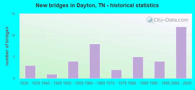
- New bridges - historical statistics
- 31930-1939
- 11940-1949
- 41950-1959
- 81960-1969
- 21970-1979
- 51980-1989
- 41990-1999
- 122000-2009
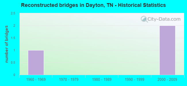
- Reconstructed bridges - Historical Statistics
- 11960-1969
- 01970-1979
- 01980-1989
- 01990-1999
- 22000-2009
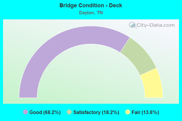
- Bridge Condition - Deck
- 68.2%Good
- 18.2%Satisfactory
- 13.6%Fair
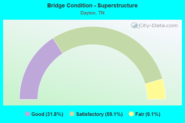
- Bridge Condition - Superstructure
- 31.8%Good
- 59.1%Satisfactory
- 9.1%Fair
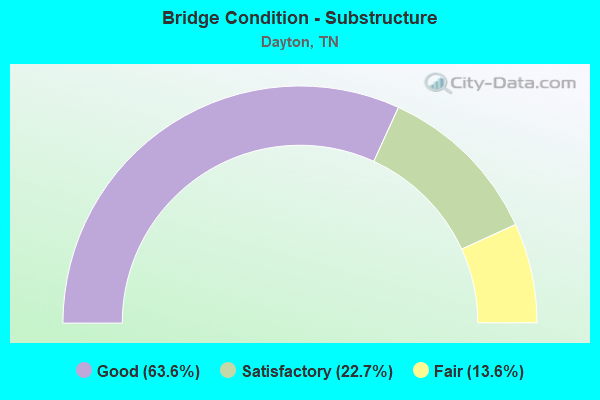
- Bridge Condition - Substructure
- 63.6%Good
- 22.7%Satisfactory
- 13.6%Fair
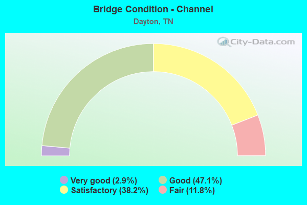
- Bridge Condition - Channel
- 2.9%Very good
- 47.1%Good
- 38.2%Satisfactory
- 11.8%Fair
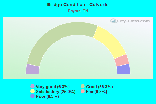
- Bridge Condition - Culverts
- 6.3%Very good
- 56.3%Good
- 25.0%Satisfactory
- 6.3%Fair
- 6.3%Poor
Find on map >> Show street view
Structure Number: 72022790001, Location: 3MI EAST OF US 27 (Lat: 35.455689, Lng: -84.996183), Route carried "on" structure: County highway 2279, Year Built: 1938, Status: Open, Structure Length: 1.34m (4.40ft), Average Daily Traffic: 695 (year 2020), Truck Traffic: 3%, Average Future Daily Traffic: 1,088 (year 2040), Design Load: H 15, Features Intersected: SEXTON CREEK
Minimum Vertical Clearance: 30+ m (98+ ft), Kilometerpoint: 4.892, Lanes on structure: 2, Owner: County Highway Agency, Approaching Roadway Width: 6.4m (21.0ft), Skew: 3 degrees, Material/Design: Concrete continuous, Design/Construction: Culvert, Number Of Spans In Main Unit: 3, Length of Maximum Span: 3.7m (12.1ft)
Condition: Channel: Satisfactory, Culverts: Good, Operating Rating: 48.6 metric tons, Method Used To Determine Operating Rating: Load Factor (LF), Inventory Rating: 28.8 metric tons, Method Used To Determine Inventory Rating: Load Factor (LF), Structural Evaluation: Better than present minimum criteria, Waterway Adequacy: Equal to present minimum criteria, Approach Roadway Alignment: Equal to present desirable criteria, Designated Inspection Frequency: Every 24 months, Inspection Date: October 2020
Find on map >> Show street view
Structure Number: 72022840001, Location: 3MI SOUTH OF SR 30 (Lat: 35.480661, Lng: -84.956844), Route carried "on" structure: County highway 710, Year Built: 2009, Status: Open, Structure Length: 2.58m (8.46ft), Average Daily Traffic: 670 (year 2018), Truck Traffic: 9%, Average Future Daily Traffic: 1,216 (year 2039), Design Load: HL 93, Features Intersected: RATTAN BRANCH, Facility Carried by Structure: NFA 2284 (SA 7206)
Minimum Vertical Clearance: 30+ m (98+ ft), Kilometerpoint: 4.635, Lanes on structure: 2, Owner: County Highway Agency, Approaching Roadway Width: 8.4m (27.6ft), Material/Design: Prestressed concrete, Design/Construction: Box Beam or Girders - Single/Spread, Number Of Spans In Main Unit: 1, Length of Maximum Span: 25.8m (84.6ft), Curb-To-Curb Width: 7.9m (25.9ft), Out-to-Out Width: 8.6m (28.2ft)
Condition: Deck: Good, Superstructure: Satisfactory, Substructure: Good, Channel: Good, Operating Rating: 54.1 metric tons, Method Used To Determine Operating Rating: Assigned ratings based on Load and Resistance Factor Design (LRFD) reported by rating factor (RF) using HL93 loadings, Inventory Rating: 32.4 metric tons, Method Used To Determine Inventory Rating: Assigned ratings based on Load and Resistance Factor Design (LRFD) reported by rating factor (RF) using HL93 loadings, Structural Evaluation: Equal to present minimum criteria, Deck Geometry: Somewhat better than minimum adequacy, Waterway Adequacy: Better than present minimum criteria, Approach Roadway Alignment: Equal to present desirable criteria, Designated Inspection Frequency: Every 24 months, Inspection Date: October 2020, Deck Structure Type: Concrete Cast-file-Place, Wearing Surface/Protective System: Wearing Surface: Monolithic Concrete
Find on map >> Show street view
Structure Number: 720A0110001, Location: EVENSVILLE MOUNTAIN RD (Lat: 35.559833, Lng: -84.952833), Route carried "on" structure: County highway 11, Year Built: 1999, Status: Open, Structure Length: 1.16m (3.81ft), Average Daily Traffic: 510 (year 2022), Truck Traffic: 2%, Average Future Daily Traffic: 816 (year 2040), Design Load: HS 20, Features Intersected: LITTLE RICHLAND CREEK
Minimum Vertical Clearance: 30+ m (98+ ft), Kilometerpoint: 0.360, Lanes on structure: 2, Owner: County Highway Agency, Approaching Roadway Width: 8.8m (28.9ft), Material/Design: Prestressed concrete, Design/Construction: Box Beam or Girders - Single/Spread, Number Of Spans In Main Unit: 1, Length of Maximum Span: 11.6m (38.1ft), Curb-To-Curb Width: 7.3m (24.0ft), Out-to-Out Width: 8.0m (26.2ft)
Condition: Deck: Good, Superstructure: Good, Substructure: Good, Channel: Good, Operating Rating: 44.1 metric tons, Method Used To Determine Operating Rating: Assigned rating based on Load Factor Design (LFD) reported in metric tons, Inventory Rating: 32.4 metric tons, Method Used To Determine Inventory Rating: Assigned rating based on Load Factor Design (LFD) reported in metric tons, Structural Evaluation: Better than present minimum criteria, Deck Geometry: Meets minimum limits, Waterway Adequacy: Better than present minimum criteria, Approach Roadway Alignment: Equal to present desirable criteria, Designated Inspection Frequency: Every 24 months, Inspection Date: October 2020, Deck Structure Type: Concrete Precast Panels, Wearing Surface/Protective System: Wearing Surface: Monolithic Concrete, Deck Protection: Epoxy Coated Reinforcing
Find on map >> Show street view
Structure Number: 720A0620001, Location: 4 MI SO OF SR30 (Lat: 35.522967, Lng: -85.071967), Route carried "on" structure: County highway 62, Year Built: 1987, Status: Open, Structure Length: 0.91m (2.99ft), Average Daily Traffic: 100 (year 2022), Truck Traffic: 4%, Average Future Daily Traffic: 160 (year 2040), Design Load: HS 20, Features Intersected: MORGAN CREEK
Minimum Vertical Clearance: 30+ m (98+ ft), Kilometerpoint: 0.301, Lanes on structure: 2, Owner: County Highway Agency, Approaching Roadway Width: 6.1m (20.0ft), Skew: 3 degrees, Material/Design: Concrete continuous, Design/Construction: Culvert, Number Of Spans In Main Unit: 2, Length of Maximum Span: 3.4m (11.2ft), Curb-To-Curb Width: 7.4m (24.3ft), Out-to-Out Width: 8.6m (28.2ft)
Condition: Channel: Satisfactory, Culverts: Good, Operating Rating: 89.1 metric tons, Method Used To Determine Operating Rating: Load Factor (LF), Inventory Rating: 32.4 metric tons, Method Used To Determine Inventory Rating: Load Factor (LF), Structural Evaluation: Better than present minimum criteria, Deck Geometry: Equal to present minimum criteria, Waterway Adequacy: Better than present minimum criteria, Approach Roadway Alignment: Equal to present desirable criteria, Designated Inspection Frequency: Every 24 months, Inspection Date: October 2020, Deck Structure Type: Concrete Cast-file-Place, Wearing Surface/Protective System: Wearing Surface: Bituminous, Deck Protection: Epoxy Coated Reinforcing
Find on map >> Show street view
Structure Number: 720A0980001, Location: 1 MI N OF DAYTON (Lat: 35.527300, Lng: -84.988683), Route carried "on" structure: City street 5416, Year Built: 1991, Status: Open, Structure Length: 2.04m (6.69ft), Average Daily Traffic: 1,830 (year 2020), Truck Traffic: 4%, Average Future Daily Traffic: 5,040 (year 2040), Design Load: HS 20, Features Intersected: RICHLAND CREEK
Minimum Vertical Clearance: 30+ m (98+ ft), Kilometerpoint: 2.012, Lanes on structure: 3, Owner: City or Municipal Highway Agency, Approaching Roadway Width: 15.8m (51.8ft), Skew: 1 degrees, Material/Design: Concrete continuous, Design/Construction: Culvert, Number Of Spans In Main Unit: 4, Length of Maximum Span: 4.6m (15.1ft)
Condition: Channel: Fair, Culverts: Good, Operating Rating: 44.1 metric tons, Method Used To Determine Operating Rating: Load Factor (LF), Inventory Rating: 27.9 metric tons, Method Used To Determine Inventory Rating: Load Factor (LF), Structural Evaluation: Better than present minimum criteria, Waterway Adequacy: Equal to present minimum criteria, Approach Roadway Alignment: Equal to present desirable criteria, Designated Inspection Frequency: Every 24 months, Inspection Date: October 2020, Deck Structure Type: Concrete Cast-file-Place, Wearing Surface/Protective System: Wearing Surface: Bituminous
Find on map >> Show street view
Structure Number: 720A1110001, Location: .1 MI EAST OF US 27 (Lat: 35.482283, Lng: -85.022050), Route carried "on" structure: City street 111, Year Built: 1955, Status: Open, Structure Length: 1.43m (4.69ft), Average Daily Traffic: 2,280 (year 2022), Average Future Daily Traffic: 3,648 (year 2040), Design Load: H 15, Features Intersected: BROYLES BRANCH
Minimum Vertical Clearance: 30+ m (98+ ft), Kilometerpoint: 1.109, Lanes on structure: 2, Owner: City or Municipal Highway Agency, Approaching Roadway Width: 15.2m (49.9ft), Material/Design: Concrete continuous, Design/Construction: Culvert, Number Of Spans In Main Unit: 3, Length of Maximum Span: 4.9m (16.1ft)
Condition: Channel: Satisfactory, Culverts: Satisfactory, Operating Rating: 26.1 metric tons, Method Used To Determine Operating Rating: Load Factor (LF), Inventory Rating: 24.3 metric tons, Method Used To Determine Inventory Rating: Load Factor (LF), Structural Evaluation: Equal to present minimum criteria, Waterway Adequacy: Equal to present minimum criteria, Approach Roadway Alignment: Equal to present desirable criteria, Designated Inspection Frequency: Every 24 months, Inspection Date: October 2020
Find on map >> Show street view
Structure Number: 720A1200001, Location: 1 MI EAST OF DAYTON (Lat: 35.501967, Lng: -85.024950), Route carried "on" structure: County highway 120, Year Built: 1995, Status: Open, Structure Length: 0.79m (2.59ft), Average Daily Traffic: 210 (year 2022), Truck Traffic: 10%, Average Future Daily Traffic: 336 (year 2038), Design Load: HS 20, Features Intersected: BLACK CREEK
Minimum Vertical Clearance: 30+ m (98+ ft), Kilometerpoint: 0.047, Lanes on structure: 2, Owner: County Highway Agency, Approaching Roadway Width: 5.2m (17.1ft), Material/Design: Concrete continuous, Design/Construction: Culvert, Number Of Spans In Main Unit: 2, Length of Maximum Span: 3.7m (12.1ft), Curb-To-Curb Width: 8.1m (26.6ft), Out-to-Out Width: 9.8m (32.2ft)
Condition: Channel: Satisfactory, Culverts: Good, Operating Rating: 54.9 metric tons, Method Used To Determine Operating Rating: Load Factor (LF), Inventory Rating: 32.4 metric tons, Method Used To Determine Inventory Rating: Load Factor (LF), Structural Evaluation: Better than present minimum criteria, Deck Geometry: Somewhat better than minimum adequacy, Waterway Adequacy: Equal to present minimum criteria, Approach Roadway Alignment: Equal to present desirable criteria, Designated Inspection Frequency: Every 24 months, Inspection Date: October 2020, Deck Structure Type: Concrete Cast-file-Place, Wearing Surface/Protective System: Wearing Surface: Monolithic Concrete, Deck Protection: Epoxy Coated Reinforcing
Find on map >> Show street view
Structure Number: 720A1210001, Location: 1 MI EAST OF DAYTON (Lat: 35.503761, Lng: -85.024464), Route carried "on" structure: County highway 121, Year Built: 1993, Status: Open, Structure Length: 0.79m (2.59ft), Average Daily Traffic: 600 (year 2022), Truck Traffic: 4%, Average Future Daily Traffic: 960 (year 2040), Design Load: HS 20, Features Intersected: BRANCH
Minimum Vertical Clearance: 30+ m (98+ ft), Kilometerpoint: 0.816, Lanes on structure: 2, Owner: County Highway Agency, Approaching Roadway Width: 6.7m (22.0ft), Material/Design: Concrete continuous, Design/Construction: Culvert, Number Of Spans In Main Unit: 2, Length of Maximum Span: 3.7m (12.1ft), Curb-To-Curb Width: 7.4m (24.3ft), Out-to-Out Width: 9.7m (31.8ft)
Condition: Channel: Good, Culverts: Good, Operating Rating: 54.9 metric tons, Method Used To Determine Operating Rating: Load Factor (LF), Inventory Rating: 32.4 metric tons, Method Used To Determine Inventory Rating: Load Factor (LF), Structural Evaluation: Better than present minimum criteria, Deck Geometry: Meets minimum limits, Waterway Adequacy: Better than present minimum criteria, Approach Roadway Alignment: Equal to present desirable criteria, Designated Inspection Frequency: Every 24 months, Inspection Date: October 2020, Deck Structure Type: Concrete Cast-file-Place, Wearing Surface/Protective System: Wearing Surface: Monolithic Concrete
Find on map >> Show street view
Structure Number: 720A1390001, Location: 0.8 MI W OF SR29 (Lat: 35.503233, Lng: -85.006000), Route carried "on" structure: City street 670, Year Built: 1977, Status: Open, Structure Length: 2.04m (6.69ft), Average Daily Traffic: 2,310 (year 2018), Truck Traffic: 3%, Average Future Daily Traffic: 3,696 (year 2040), Design Load: HS 20, Features Intersected: LITTLE RICHLAND CREEK
Minimum Vertical Clearance: 30+ m (98+ ft), Kilometerpoint: 0.436, Lanes on structure: 2, Owner: City or Municipal Highway Agency, Approaching Roadway Width: 12.8m (42.0ft), Skew: 1 degrees, Material/Design: Prestressed concrete, Design/Construction: Box Beam or Girders - Multiple, Number Of Spans In Main Unit: 1, Length of Maximum Span: 18.9m (62.0ft), Curb-To-Curb Width: 9.8m (32.2ft), Out-to-Out Width: 11.0m (36.1ft)
Condition: Deck: Good, Superstructure: Satisfactory, Substructure: Satisfactory, Channel: Good, Operating Rating: 44.1 metric tons, Method Used To Determine Operating Rating: Assigned rating based on Load Factor Design (LFD) reported in metric tons, Inventory Rating: 32.4 metric tons, Method Used To Determine Inventory Rating: Assigned rating based on Load Factor Design (LFD) reported in metric tons, Structural Evaluation: Equal to present minimum criteria, Deck Geometry: Meets minimum limits, Waterway Adequacy: Better than present minimum criteria, Approach Roadway Alignment: Equal to present desirable criteria, Designated Inspection Frequency: Every 24 months, Inspection Date: October 2020, Deck Structure Type: Concrete Cast-file-Place, Wearing Surface/Protective System: Wearing Surface: Bituminous
Find on map >> Show street view
Structure Number: 720A1430001, Location: 1.1 NW OF SR29 (Lat: 35.517533, Lng: -85.000017), Route carried "on" structure: City street 4199, Year Built: 1969, Status: Open, Structure Length: 4.24m (13.91ft), Average Daily Traffic: 3,771 (year 2020), Truck Traffic: 4%, Average Future Daily Traffic: 8,400 (year 2041), Design Load: H 15, Features Intersected: LITTLE RICHLAND CREEK
Minimum Vertical Clearance: 30+ m (98+ ft), Kilometerpoint: 1.062, Lanes on structure: 2, Owner: City or Municipal Highway Agency, Approaching Roadway Width: 7.3m (24.0ft), Skew: 3 degrees, Material/Design: Prestressed concrete continuous, Design/Construction: Stringer/Multi-beam, Number Of Spans In Main Unit: 3, Length of Maximum Span: 13.7m (44.9ft), Curb-To-Curb Width: 7.3m (24.0ft), Out-to-Out Width: 8.7m (28.5ft)
Condition: Deck: Satisfactory, Superstructure: Fair, Substructure: Fair, Channel: Satisfactory, Operating Rating: 36.0 metric tons, Method Used To Determine Operating Rating: Field evaluation and documented engineering judgment, Inventory Rating: 24.3 metric tons, Method Used To Determine Inventory Rating: Field evaluation and documented engineering judgment, Structural Evaluation: Somewhat better than minimum adequacy, Deck Geometry: High priority of replacement, Waterway Adequacy: Equal to present minimum criteria, Approach Roadway Alignment: Equal to present desirable criteria, Length Of Structure Improvement: 4.24m (13.91ft), Designated Inspection Frequency: Every 24 months, Inspection Date: October 2020, Bridge Improvement Cost: $515,000, Roadway Improvement Cost: $52,000, Total Project Cost: $773,000 ( Estimate for 2021), Deck Structure Type: Concrete Cast-file-Place, Wearing Surface/Protective System: Wearing Surface: Bituminous
Find on map >> Show street view
Structure Number: 720A1460001, Location: .03 MI FROM SR 29 (Lat: 35.551094, Lng: -84.965108), Route carried "on" structure: County highway 146, Year Built: 2003, Status: Open, Structure Length: 1.52m (4.99ft), Average Daily Traffic: 1,050 (year 2022), Truck Traffic: 2%, Average Future Daily Traffic: 1,680 (year 2040), Design Load: HS 20, Features Intersected: LITTLE RICHLAND CREEK
Minimum Vertical Clearance: 30+ m (98+ ft), Kilometerpoint: 0.085, Lanes on structure: 2, Owner: County Highway Agency, Approaching Roadway Width: 9.0m (29.5ft), Material/Design: Prestressed concrete, Design/Construction: Box Beam or Girders - Multiple, Number Of Spans In Main Unit: 1, Length of Maximum Span: 14.9m (48.9ft), Curb-To-Curb Width: 9.0m (29.5ft), Out-to-Out Width: 10.1m (33.1ft)
Condition: Deck: Good, Superstructure: Good, Substructure: Good, Channel: Good, Operating Rating: 44.1 metric tons, Method Used To Determine Operating Rating: Assigned rating based on Load Factor Design (LFD) reported in metric tons, Inventory Rating: 32.4 metric tons, Method Used To Determine Inventory Rating: Assigned rating based on Load Factor Design (LFD) reported in metric tons, Structural Evaluation: Better than present minimum criteria, Deck Geometry: Somewhat better than minimum adequacy, Waterway Adequacy: Better than present minimum criteria, Approach Roadway Alignment: Equal to present desirable criteria, Designated Inspection Frequency: Every 24 months, Inspection Date: October 2020, Deck Structure Type: Concrete Cast-file-Place
Find on map >> Show street view
Structure Number: 720A4420001, Location: 5MI SOUTH OF SR 30 (Lat: 35.485817, Lng: -84.938839), Route carried "on" structure: County highway 442, Year Built: 1938, Status: Open, Structure Length: 0.64m (2.10ft), Average Daily Traffic: 1,290 (year 2022), Truck Traffic: 10%, Average Future Daily Traffic: 2,064 (year 2040), Design Load: H 15, Features Intersected: BROWN BRANCH
Minimum Vertical Clearance: 30+ m (98+ ft), Kilometerpoint: 0.763, Lanes on structure: 2, Owner: County Highway Agency, Approaching Roadway Width: 7.9m (25.9ft), Material/Design: Concrete continuous, Design/Construction: Culvert, Number Of Spans In Main Unit: 2, Length of Maximum Span: 3.0m (9.8ft)
Condition: Channel: Good, Culverts: Good, Operating Rating: 45.0 metric tons, Method Used To Determine Operating Rating: Load Factor (LF), Inventory Rating: 27.9 metric tons, Method Used To Determine Inventory Rating: Load Factor (LF), Structural Evaluation: Better than present minimum criteria, Waterway Adequacy: Equal to present minimum criteria, Approach Roadway Alignment: Equal to present desirable criteria, Length Of Structure Improvement: 0.64m (2.10ft), Designated Inspection Frequency: Every 24 months, Inspection Date: October 2020, Bridge Improvement Cost: $127,000, Roadway Improvement Cost: $13,000, Total Project Cost: $191,000 ( Estimate for 2020)
Find on map >> Show street view
Structure Number: 720A4980001, Location: 3 MI NW OF SR29 (Lat: 35.475767, Lng: -85.031917), Route carried "on" structure: City street 498, Year Built: 1984, Status: Open, Structure Length: 1.13m (3.71ft), Average Daily Traffic: 140 (year 2022), Truck Traffic: 4%, Average Future Daily Traffic: 224 (year 2040), Design Load: HS 20, Features Intersected: BROYLES BRANCH
Minimum Vertical Clearance: 30+ m (98+ ft), Kilometerpoint: 0.426, Lanes on structure: 2, Owner: City or Municipal Highway Agency, Approaching Roadway Width: 6.1m (20.0ft), Skew: 4 degrees, Material/Design: Concrete continuous, Design/Construction: Culvert, Number Of Spans In Main Unit: 2, Length of Maximum Span: 3.7m (12.1ft), Curb-To-Curb Width: 6.7m (22.0ft), Out-to-Out Width: 8.4m (27.6ft)
Condition: Channel: Good, Culverts: Satisfactory, Operating Rating: 58.5 metric tons, Method Used To Determine Operating Rating: Load Factor (LF), Inventory Rating: 32.4 metric tons, Method Used To Determine Inventory Rating: Load Factor (LF), Structural Evaluation: Equal to present minimum criteria, Deck Geometry: Meets minimum limits, Waterway Adequacy: Better than present minimum criteria, Approach Roadway Alignment: Equal to present desirable criteria, Designated Inspection Frequency: Every 24 months, Inspection Date: October 2020, Deck Structure Type: Concrete Cast-file-Place, Wearing Surface/Protective System: Wearing Surface: Monolithic Concrete, Deck Protection: Epoxy Coated Reinforcing
Find on map >> Show street view
Structure Number: 720A5230001, Location: .02 MI FROM SR 29 (Lat: 35.543933, Lng: -84.970533), Route carried "on" structure: County highway 523, Year Built: 2003, Status: Open, Structure Length: 1.53m (5.02ft), Average Daily Traffic: 130 (year 2022), Truck Traffic: 2%, Average Future Daily Traffic: 208 (year 2038), Design Load: HS 20, Features Intersected: RICHLAND CREEK
Minimum Vertical Clearance: 30+ m (98+ ft), Kilometerpoint: 0.043, Lanes on structure: 2, Owner: County Highway Agency, Approaching Roadway Width: 6.1m (20.0ft), Skew: 1 degrees, Material/Design: Concrete, Design/Construction: Box Beam or Girders - Multiple, Number Of Spans In Main Unit: 1, Length of Maximum Span: 15.0m (49.2ft), Curb-To-Curb Width: 8.1m (26.6ft), Out-to-Out Width: 8.1m (26.6ft)
Condition: Deck: Good, Superstructure: Good, Substructure: Good, Channel: Good, Operating Rating: 44.1 metric tons, Method Used To Determine Operating Rating: Assigned rating based on Load Factor Design (LFD) reported in metric tons, Inventory Rating: 32.4 metric tons, Method Used To Determine Inventory Rating: Assigned rating based on Load Factor Design (LFD) reported in metric tons, Structural Evaluation: Better than present minimum criteria, Deck Geometry: Somewhat better than minimum adequacy, Waterway Adequacy: Better than present minimum criteria, Approach Roadway Alignment: Equal to present desirable criteria, Designated Inspection Frequency: Every 24 months, Inspection Date: October 2020, Deck Structure Type: Concrete Cast-file-Place, Wearing Surface/Protective System: Wearing Surface: Integral Concrete, Deck Protection: Epoxy Coated Reinforcing
Find on map >> Show street view
Structure Number: 720A5490001, Location: 0.30 MI W OF SR29 (Lat: 35.507650, Lng: -85.001133), Route carried "on" structure: City street 4078, Year Built: 2003, Status: Open, Structure Length: 1.80m (5.91ft), Average Daily Traffic: 2,759 (year 2020), Truck Traffic: 4%, Average Future Daily Traffic: 2,160 (year 2039), Design Load: HS 20, Features Intersected: LITTLE RICHLAND CREEK
Minimum Vertical Clearance: 30+ m (98+ ft), Kilometerpoint: 0.483, Lanes on structure: 4, Owner: City or Municipal Highway Agency, Approaching Roadway Width: 15.4m (50.5ft), Material/Design: Prestressed concrete, Design/Construction: Box Beam or Girders - Multiple, Number Of Spans In Main Unit: 1, Length of Maximum Span: 17.4m (57.1ft), Curb-To-Curb Width: 15.4m (50.5ft), Out-to-Out Width: 16.5m (54.1ft)
Condition: Deck: Good, Superstructure: Good, Substructure: Satisfactory, Channel: Very good, Operating Rating: 44.1 metric tons, Method Used To Determine Operating Rating: Assigned rating based on Load Factor Design (LFD) reported in metric tons, Inventory Rating: 32.4 metric tons, Method Used To Determine Inventory Rating: Assigned rating based on Load Factor Design (LFD) reported in metric tons, Structural Evaluation: Equal to present minimum criteria, Deck Geometry: Meets minimum limits, Waterway Adequacy: Equal to present desirable criteria, Approach Roadway Alignment: Equal to present desirable criteria, Designated Inspection Frequency: Every 24 months, Inspection Date: October 2020, Deck Structure Type: Concrete Cast-file-Place
Find on map >> Show street view
Structure Number: 720A6250001, Location: .5MI FROM SR29 IN DAYTON (Lat: 35.479500, Lng: -85.023267), Route carried "on" structure: City street 18, Year Built: 1984, Status: Open, Structure Length: 1.52m (4.99ft), Average Daily Traffic: 1,210 (year 2022), Truck Traffic: 2%, Average Future Daily Traffic: 1,936 (year 2040), Design Load: HS 20, Features Intersected: BROYLE'S CREEK
Minimum Vertical Clearance: 30+ m (98+ ft), Kilometerpoint: 0.080, Lanes on structure: 2, Owner: City or Municipal Highway Agency, Approaching Roadway Width: 9.4m (30.8ft), Skew: 1 degrees, Material/Design: Concrete continuous, Design/Construction: Culvert, Number Of Spans In Main Unit: 3, Length of Maximum Span: 4.6m (15.1ft), Curb-To-Curb Width: 8.0m (26.2ft), Out-to-Out Width: 9.5m (31.2ft)
Condition: Channel: Satisfactory, Culverts: Satisfactory, Operating Rating: 89.1 metric tons, Method Used To Determine Operating Rating: Load Factor (LF), Inventory Rating: 32.4 metric tons, Method Used To Determine Inventory Rating: Load Factor (LF), Structural Evaluation: Equal to present minimum criteria, Deck Geometry: Meets minimum limits, Waterway Adequacy: Equal to present minimum criteria, Approach Roadway Alignment: Equal to present desirable criteria, Designated Inspection Frequency: Every 24 months, Inspection Date: October 2020, Deck Structure Type: Concrete Cast-file-Place, Wearing Surface/Protective System: Wearing Surface: Bituminous
Find on map >> Show street view
Structure Number: 720A6810001, Location: 5 MI NW JCT SR29 & SR30 (Lat: 35.536383, Lng: -84.979000), Route carried "on" structure: County highway 523, Year Built: 2003, Status: Open, Structure Length: 1.04m (3.41ft), Average Daily Traffic: 130 (year 2022), Truck Traffic: 4%, Average Future Daily Traffic: 208 (year 2040), Design Load: HS 15, Features Intersected: LITTLE RICHLAND CREEK
Minimum Vertical Clearance: 30+ m (98+ ft), Kilometerpoint: 0.241, Lanes on structure: 2, Owner: County Highway Agency, Approaching Roadway Width: 5.5m (18.0ft), Material/Design: Concrete continuous, Design/Construction: Culvert, Number Of Spans In Main Unit: 2, Length of Maximum Span: 4.9m (16.1ft), Curb-To-Curb Width: 6.6m (21.7ft), Out-to-Out Width: 8.4m (27.6ft)
Condition: Channel: Satisfactory, Culverts: Good, Operating Rating: 44.1 metric tons, Method Used To Determine Operating Rating: Field evaluation and documented engineering judgment, Inventory Rating: 24.3 metric tons, Method Used To Determine Inventory Rating: Field evaluation and documented engineering judgment, Structural Evaluation: Equal to present minimum criteria, Waterway Adequacy: Equal to present minimum criteria, Approach Roadway Alignment: Equal to present desirable criteria, Length Of Structure Improvement: 1.04m (3.41ft), Designated Inspection Frequency: Every 24 months, Inspection Date: October 2020, Bridge Improvement Cost: $44,000, Roadway Improvement Cost: $5,000, Total Project Cost: $67,000 ( Estimate for 2020), Deck Structure Type: Concrete Cast-file-Place, Wearing Surface/Protective System: Wearing Surface: Gravel
Find on map >> Show street view
Structure Number: 72S42650001, Location: 3MI SOUTH OF SR 30 (Lat: 35.519511, Lng: -85.074528), Route carried "on" structure: State highway 443, Year Built: 1954, Status: Open, Structure Length: 0.67m (2.20ft), Average Daily Traffic: 1,187 (year 2020), Truck Traffic: 3%, Average Future Daily Traffic: 2,064 (year 2040), Design Load: H 15, Features Intersected: WELLER BRANCH
Minimum Vertical Clearance: 30+ m (98+ ft), Kilometerpoint: 8.401, Lanes on structure: 2, Owner: State Highway Agency, Approaching Roadway Width: 7.9m (25.9ft), Material/Design: Concrete continuous, Design/Construction: Culvert, Number Of Spans In Main Unit: 2, Length of Maximum Span: 3.0m (9.8ft), Curb-To-Curb Width: 6.7m (22.0ft), Out-to-Out Width: 7.9m (25.9ft)
Condition: Channel: Good, Culverts: Good, Operating Rating: 36.9 metric tons, Method Used To Determine Operating Rating: Load Factor (LF), Inventory Rating: 22.5 metric tons, Method Used To Determine Inventory Rating: Load Factor (LF), Structural Evaluation: Equal to present minimum criteria, Deck Geometry: High priority of corrective action, Waterway Adequacy: Equal to present minimum criteria, Approach Roadway Alignment: Equal to present minimum criteria, Length Of Structure Improvement: 0.67m (2.20ft), Designated Inspection Frequency: Every 24 months, Inspection Date: September 2020, Bridge Improvement Cost: $70,000, Roadway Improvement Cost: $8,000, Total Project Cost: $106,000 ( Estimate for 2020), Deck Structure Type: Concrete Cast-file-Place, Wearing Surface/Protective System: Wearing Surface: Bituminous
Find on map >> Show street view
Structure Number: 72S43760003, Location: 1MI EAST OF US27 (Lat: 35.508036, Lng: -85.022511), Route carried "on" structure: County highway 2331, Year Built: 1985, Status: Open, Structure Length: 4.60m (15.09ft), Average Daily Traffic: 1,213 (year 2020), Truck Traffic: 3%, Average Future Daily Traffic: 2,288 (year 2040), Design Load: HS 20, Features Intersected: RICHLAND CREEK, Facility Carried by Structure: NFA 1195 (SA 7204)
Minimum Vertical Clearance: 30+ m (98+ ft), Kilometerpoint: 1.014, Lanes on structure: 2, Owner: County Highway Agency, Approaching Roadway Width: 6.7m (22.0ft), Material/Design: Prestressed concrete, Design/Construction: Box Beam or Girders - Single/Spread, Number Of Spans In Main Unit: 3, Length of Maximum Span: 9.4m (30.8ft), Curb-To-Curb Width: 11.6m (38.1ft), Out-to-Out Width: 12.3m (40.4ft)
Condition: Deck: Good, Superstructure: Satisfactory, Substructure: Good, Channel: Good, Operating Rating: 63.3 metric tons, Method Used To Determine Operating Rating: Load Factor (LF), Inventory Rating: 32.4 metric tons, Method Used To Determine Inventory Rating: Load Factor (LF), Structural Evaluation: Equal to present minimum criteria, Deck Geometry: Equal to present minimum criteria, Waterway Adequacy: Equal to present desirable criteria, Approach Roadway Alignment: Equal to present minimum criteria, Designated Inspection Frequency: Every 24 months, Inspection Date: October 2020, Deck Structure Type: Concrete Precast Panels, Wearing Surface/Protective System: Wearing Surface: Monolithic Concrete, Deck Protection: Epoxy Coated Reinforcing
Find on map >> Show street view
Structure Number: 72S43760005, Location: 1MI WEST OF US 27 (Lat: 35.556983, Lng: -84.991883), Route carried "on" structure: County highway 2331, Year Built: 1985, Status: Open, Structure Length: 1.01m (3.31ft), Average Daily Traffic: 588 (year 2020), Truck Traffic: 4%, Average Future Daily Traffic: 656 (year 2040), Design Load: HS 20, Features Intersected: STEWARTS CREEK, Facility Carried by Structure: NFA 1195 (SA 7204)
Minimum Vertical Clearance: 30+ m (98+ ft), Kilometerpoint: 5.922, Lanes on structure: 2, Owner: County Highway Agency, Approaching Roadway Width: 8.2m (26.9ft), Material/Design: Concrete, Design/Construction: Culvert, Number Of Spans In Main Unit: 1, Length of Maximum Span: 7.0m (23.0ft)
Condition: Channel: Fair, Culverts: Good, Operating Rating: 58.5 metric tons, Method Used To Determine Operating Rating: Load Factor (LF), Inventory Rating: 32.4 metric tons, Method Used To Determine Inventory Rating: Load Factor (LF), Structural Evaluation: Better than present minimum criteria, Waterway Adequacy: Better than present minimum criteria, Approach Roadway Alignment: Equal to present minimum criteria, Designated Inspection Frequency: Every 24 months, Inspection Date: October 2020
Find on map >> Show street view
Structure Number: 72SR0290003, Location: IN DAYTON CITY LIMITS (Lat: 35.488144, Lng: -85.015922), Route carried "on" structure: US 27, Year Built: 1960, Year Reconstructed: 2012, Status: Open, Structure Length: 9.57m (31.40ft), Average Daily Traffic: 23,807 (year 2020), Truck Traffic: 9%, Average Future Daily Traffic: 37,712 (year 2040), Design Load: H 20, Features Intersected: RICHLAND CREEK, Facility Carried by Structure: FAP 29
Minimum Vertical Clearance: 30+ m (98+ ft), Kilometerpoint: 8.980, Lanes on structure: 2, Base Highway Network: Yes, Owner: State Highway Agency, Approaching Roadway Width: 12.2m (40.0ft), Skew: 10 degrees, Material/Design: Concrete, Design/Construction: Tee Beam, Number Of Spans In Main Unit: 5, Length of Maximum Span: 8.8m (28.9ft), Curb-To-Curb Width: 12.2m (40.0ft), Out-to-Out Width: 12.6m (41.3ft)
Condition: Deck: Fair, Superstructure: Satisfactory, Substructure: Satisfactory, Channel: Satisfactory, Operating Rating: 51.3 metric tons, Method Used To Determine Operating Rating: Load Factor (LF), Inventory Rating: 30.6 metric tons, Method Used To Determine Inventory Rating: Load Factor (LF), Structural Evaluation: Equal to present minimum criteria, Deck Geometry: Better than present minimum criteria, Waterway Adequacy: Equal to present desirable criteria, Approach Roadway Alignment: Equal to present desirable criteria, Designated Inspection Frequency: Every 24 months, Inspection Date: September 2020, Deck Structure Type: Concrete Cast-file-Place, Wearing Surface/Protective System: Wearing Surface: Monolithic Concrete, Deck Protection: Epoxy Coated Reinforcing
Find on map >> Show street view
Structure Number: 72SR0290004, Location: IN DAYTON CITY LIMITS (Lat: 35.487878, Lng: -85.014267), Route carried "on" structure: US 27, Year Built: 1960, Year Reconstructed: 2012, Status: Open, Structure Length: 9.57m (31.40ft), Average Daily Traffic: 23,807 (year 2020), Truck Traffic: 9%, Average Future Daily Traffic: 37,712 (year 2041), Design Load: HS 20, Features Intersected: RICHLAND CREEK, Facility Carried by Structure: FAP 29
Minimum Vertical Clearance: 30+ m (98+ ft), Kilometerpoint: 8.980, Lanes on structure: 2, Base Highway Network: Yes, Owner: State Highway Agency, Approaching Roadway Width: 12.2m (40.0ft), Skew: 10 degrees, Material/Design: Concrete, Design/Construction: Tee Beam, Number Of Spans In Main Unit: 11, Length of Maximum Span: 8.8m (28.9ft), Curb-To-Curb Width: 12.2m (40.0ft), Out-to-Out Width: 12.6m (41.3ft)
Condition: Deck: Fair, Superstructure: Satisfactory, Substructure: Satisfactory, Channel: Satisfactory, Operating Rating: 51.3 metric tons, Method Used To Determine Operating Rating: Load Factor (LF), Inventory Rating: 30.6 metric tons, Method Used To Determine Inventory Rating: Load Factor (LF), Structural Evaluation: Equal to present minimum criteria, Deck Geometry: Better than present minimum criteria, Waterway Adequacy: Equal to present desirable criteria, Approach Roadway Alignment: Equal to present desirable criteria, Designated Inspection Frequency: Every 24 months, Inspection Date: September 2020, Deck Structure Type: Concrete Cast-file-Place, Wearing Surface/Protective System: Wearing Surface: Monolithic Concrete, Deck Protection: Epoxy Coated Reinforcing
Find on map >> Show street view
Structure Number: 72SR0290005, Location: IN DAYTON CITY LIMITS (Lat: 35.490022, Lng: -85.010833), Route carried "on" structure: US 27, Year Built: 2007, Status: Open, Structure Length: 4.49m (14.73ft), Average Daily Traffic: 23,807 (year 2020), Truck Traffic: 9%, Average Future Daily Traffic: 37,712 (year 2040), Design Load: HL 93, Features Intersected: RICHLAND CREEK OVERFLOW, Facility Carried by Structure: FAP 29
Minimum Vertical Clearance: 30+ m (98+ ft), Kilometerpoint: 9.334, Lanes on structure: 2, Base Highway Network: Yes, Owner: State Highway Agency, Approaching Roadway Width: 11.3m (37.1ft), Skew: 13 degrees, Material/Design: Steel, Design/Construction: Stringer/Multi-beam, Number Of Spans In Main Unit: 1, Length of Maximum Span: 44.2m (145.0ft), Curb-To-Curb Width: 12.2m (40.0ft), Out-to-Out Width: 12.8m (42.0ft)
Condition: Deck: Good, Superstructure: Good, Substructure: Good, Channel: Good, Operating Rating: 62.1 metric tons, Method Used To Determine Operating Rating: Load Factor (LF), Inventory Rating: 32.4 metric tons, Method Used To Determine Inventory Rating: Load Factor (LF), Structural Evaluation: Better than present minimum criteria, Deck Geometry: Better than present minimum criteria, Waterway Adequacy: Equal to present desirable criteria, Approach Roadway Alignment: Equal to present desirable criteria, Designated Inspection Frequency: Every 24 months, Inspection Date: September 2020, Deck Structure Type: Concrete Precast Panels, Wearing Surface/Protective System: Wearing Surface: Monolithic Concrete, Deck Protection: Epoxy Coated Reinforcing
Find on map >> Show street view
Structure Number: 72SR0290006, Location: IN DAYTON CITY LIMITS (Lat: 35.490000, Lng: -85.011233), Route carried "on" structure: US 27, Year Built: 2007, Status: Open, Structure Length: 4.50m (14.76ft), Average Daily Traffic: 23,807 (year 2020), Truck Traffic: 9%, Average Future Daily Traffic: 37,712 (year 2041), Design Load: HL 93, Features Intersected: RICHLAND CREEK OVERFLOW, Facility Carried by Structure: FAP 29
Minimum Vertical Clearance: 30+ m (98+ ft), Kilometerpoint: 9.334, Lanes on structure: 2, Base Highway Network: Yes, Owner: State Highway Agency, Approaching Roadway Width: 11.0m (36.1ft), Skew: 13 degrees, Material/Design: Steel, Design/Construction: Stringer/Multi-beam, Number Of Spans In Main Unit: 1, Length of Maximum Span: 44.4m (145.7ft), Curb-To-Curb Width: 12.2m (40.0ft), Out-to-Out Width: 12.8m (42.0ft)
Condition: Deck: Good, Superstructure: Good, Substructure: Good, Channel: Good, Operating Rating: 62.1 metric tons, Method Used To Determine Operating Rating: Load Factor (LF), Inventory Rating: 32.4 metric tons, Method Used To Determine Inventory Rating: Load Factor (LF), Structural Evaluation: Better than present minimum criteria, Deck Geometry: Better than present minimum criteria, Waterway Adequacy: Equal to present desirable criteria, Approach Roadway Alignment: Equal to present desirable criteria, Designated Inspection Frequency: Every 24 months, Inspection Date: September 2020, Deck Structure Type: Concrete Precast Panels, Wearing Surface/Protective System: Wearing Surface: Monolithic Concrete, Deck Protection: Epoxy Coated Reinforcing
Find on map >> Show street view
Structure Number: 72SR0290027, Location: IN DAYTON CITY LIMITS (Lat: 35.494200, Lng: -85.007533), Route carried "on" structure: US 27, Year Built: 1960, Status: Open, Structure Length: 4.36m (14.30ft), Average Daily Traffic: 15,270 (year 2020), Truck Traffic: 9%, Average Future Daily Traffic: 27,360 (year 2040), Design Load: HS 20, Features Intersected: LITTLE RICHLAND CREEK, Facility Carried by Structure: FAP 29
Minimum Vertical Clearance: 30+ m (98+ ft), Kilometerpoint: 9.898, Lanes on structure: 2, Base Highway Network: Yes, Owner: State Highway Agency, Approaching Roadway Width: 12.2m (40.0ft), Skew: 10 degrees, Material/Design: Concrete, Design/Construction: Tee Beam, Number Of Spans In Main Unit: 5, Length of Maximum Span: 8.8m (28.9ft), Curb-To-Curb Width: 8.5m (27.9ft), Out-to-Out Width: 10.5m (34.4ft)
Condition: Deck: Satisfactory, Superstructure: Satisfactory, Substructure: Fair, Channel: Good, Operating Rating: 38.7 metric tons, Method Used To Determine Operating Rating: Load Factor (LF), Inventory Rating: 23.4 metric tons, Method Used To Determine Inventory Rating: Load Factor (LF), Structural Evaluation: Somewhat better than minimum adequacy, Deck Geometry: High priority of corrective action, Waterway Adequacy: Equal to present desirable criteria, Approach Roadway Alignment: Equal to present desirable criteria, Length Of Structure Improvement: 4.36m (14.30ft), Designated Inspection Frequency: Every 24 months, Inspection Date: September 2020, Bridge Improvement Cost: $330,000, Roadway Improvement Cost: $34,000, Total Project Cost: $496,000 ( Estimate for 2020), Deck Structure Type: Concrete Cast-file-Place, Wearing Surface/Protective System: Wearing Surface: Bituminous
Find on map >> Show street view
Structure Number: 72SR0290028, Location: IN DAYTON CITY LIMITS (Lat: 35.494217, Lng: -85.007383), Route carried "on" structure: US 27, Year Built: 1960, Status: Open, Structure Length: 4.36m (14.30ft), Average Daily Traffic: 15,270 (year 2020), Truck Traffic: 9%, Average Future Daily Traffic: 27,360 (year 2041), Design Load: HS 20, Features Intersected: LITTLE RICHLAND CREEK, Facility Carried by Structure: FAP 29
Minimum Vertical Clearance: 30+ m (98+ ft), Kilometerpoint: 9.898, Lanes on structure: 2, Base Highway Network: Yes, Owner: State Highway Agency, Approaching Roadway Width: 12.2m (40.0ft), Skew: 10 degrees, Material/Design: Concrete, Design/Construction: Tee Beam, Number Of Spans In Main Unit: 5, Length of Maximum Span: 8.8m (28.9ft), Curb-To-Curb Width: 8.5m (27.9ft), Out-to-Out Width: 10.5m (34.4ft)
Condition: Deck: Satisfactory, Superstructure: Satisfactory, Substructure: Satisfactory, Channel: Good, Operating Rating: 38.7 metric tons, Method Used To Determine Operating Rating: Load Factor (LF), Inventory Rating: 23.4 metric tons, Method Used To Determine Inventory Rating: Load Factor (LF), Structural Evaluation: Somewhat better than minimum adequacy, Deck Geometry: High priority of corrective action, Waterway Adequacy: Equal to present desirable criteria, Approach Roadway Alignment: Equal to present desirable criteria, Length Of Structure Improvement: 4.36m (14.30ft), Designated Inspection Frequency: Every 24 months, Inspection Date: September 2020, Bridge Improvement Cost: $330,000, Roadway Improvement Cost: $34,000, Total Project Cost: $496,000 ( Estimate for 2021), Deck Structure Type: Concrete Cast-file-Place, Wearing Surface/Protective System: Wearing Surface: Bituminous
Find on map >> Show street view
Structure Number: 72SR0290031, Location: 8.5 MILES NE.OF DAYTON (Lat: 35.557839, Lng: -84.956564), Route carried "on" structure: US 27, Year Built: 2002, Status: Open, Structure Length: 6.10m (20.01ft), Average Daily Traffic: 15,274 (year 2020), Truck Traffic: 9%, Average Future Daily Traffic: 25,504 (year 2040), Design Load: HS 20, Features Intersected: OAK HILL RD, Facility Carried by Structure: FAP 29
Minimum Vertical Clearance: 30+ m (98+ ft), Kilometerpoint: 18.660, Lanes on structure: 2, Lanes under structure: 2, Base Highway Network: Yes, Owner: State Highway Agency, Approaching Roadway Width: 11.6m (38.1ft), Material/Design: Prestressed concrete continuous, Design/Construction: Stringer/Multi-beam, Number Of Spans In Main Unit: 3, Length of Maximum Span: 20.1m (65.9ft), Curb-To-Curb Width: 12.6m (41.3ft), Out-to-Out Width: 13.2m (43.3ft)
Condition: Deck: Good, Superstructure: Satisfactory, Substructure: Good, Operating Rating: 42.3 metric tons, Method Used To Determine Operating Rating: Load Factor (LF), Inventory Rating: 32.4 metric tons, Method Used To Determine Inventory Rating: Load Factor (LF), Structural Evaluation: Equal to present minimum criteria, Deck Geometry: Somewhat better than minimum adequacy, Underclear: Superior to present desirable criteria, Approach Roadway Alignment: Equal to present desirable criteria, Designated Inspection Frequency: Every 24 months, Inspection Date: September 2020, Deck Structure Type: Concrete Cast-file-Place, Wearing Surface/Protective System: Wearing Surface: Monolithic Concrete, Deck Protection: Epoxy Coated Reinforcing
Find on map >> Show street view
Structure Number: 72SR0290032, Location: 8.5 MILES NE.OF DAYTON (Lat: 35.557981, Lng: -84.956733), Route carried "on" structure: US 27, Year Built: 2002, Status: Open, Structure Length: 6.10m (20.01ft), Average Daily Traffic: 15,274 (year 2020), Truck Traffic: 9%, Average Future Daily Traffic: 25,504 (year 2040), Design Load: HS 20, Features Intersected: OAK HILL ROAD, Facility Carried by Structure: FAP 29
Minimum Vertical Clearance: 30+ m (98+ ft), Kilometerpoint: 18.660, Lanes on structure: 2, Lanes under structure: 2, Base Highway Network: Yes, Owner: State Highway Agency, Approaching Roadway Width: 11.6m (38.1ft), Material/Design: Prestressed concrete continuous, Design/Construction: Stringer/Multi-beam, Number Of Spans In Main Unit: 3, Length of Maximum Span: 20.3m (66.6ft), Curb-To-Curb Width: 12.6m (41.3ft), Out-to-Out Width: 13.2m (43.3ft)
Condition: Deck: Good, Superstructure: Satisfactory, Substructure: Good, Operating Rating: 42.3 metric tons, Method Used To Determine Operating Rating: Load Factor (LF), Inventory Rating: 32.4 metric tons, Method Used To Determine Inventory Rating: Load Factor (LF), Structural Evaluation: Equal to present minimum criteria, Deck Geometry: Somewhat better than minimum adequacy, Underclear: Equal to present desirable criteria, Approach Roadway Alignment: Equal to present desirable criteria, Designated Inspection Frequency: Every 24 months, Inspection Date: September 2020, Deck Structure Type: Concrete Cast-file-Place, Wearing Surface/Protective System: Wearing Surface: Monolithic Concrete, Deck Protection: Epoxy Coated Reinforcing
Find on map >> Show street view
Structure Number: 72SR0290033, Location: 8.5 MILES NE.OF DAYTON (Lat: 35.561850, Lng: -84.951583), Route carried "on" structure: US 27, Year Built: 2003, Status: Open, Structure Length: 5.00m (16.40ft), Average Daily Traffic: 15,274 (year 2020), Truck Traffic: 9%, Average Future Daily Traffic: 25,504 (year 2040), Design Load: HS 20, Features Intersected: WHITES FLAT ROAD, Facility Carried by Structure: FAP 29
Minimum Vertical Clearance: 30+ m (98+ ft), Kilometerpoint: 19.360, Lanes on structure: 2, Lanes under structure: 2, Base Highway Network: Yes, Owner: State Highway Agency, Approaching Roadway Width: 11.6m (38.1ft), Material/Design: Prestressed concrete continuous, Design/Construction: Stringer/Multi-beam, Number Of Spans In Main Unit: 3, Length of Maximum Span: 20.0m (65.6ft), Curb-To-Curb Width: 12.6m (41.3ft), Out-to-Out Width: 13.2m (43.3ft)
Condition: Deck: Good, Superstructure: Satisfactory, Substructure: Good, Operating Rating: 58.5 metric tons, Method Used To Determine Operating Rating: Load Factor (LF), Inventory Rating: 32.4 metric tons, Method Used To Determine Inventory Rating: Load Factor (LF), Structural Evaluation: Equal to present minimum criteria, Deck Geometry: Somewhat better than minimum adequacy, Underclear: Superior to present desirable criteria, Approach Roadway Alignment: Equal to present desirable criteria, Designated Inspection Frequency: Every 24 months, Inspection Date: September 2020, Deck Structure Type: Concrete Cast-file-Place, Wearing Surface/Protective System: Wearing Surface: Monolithic Concrete, Deck Protection: Epoxy Coated Reinforcing
Find on map >> Show street view
Structure Number: 72SR0290034, Location: 8.5 MILES NE.OF DAYTON (Lat: 35.562600, Lng: -84.951983), Route carried "on" structure: US 27, Year Built: 2003, Status: Open, Structure Length: 5.00m (16.40ft), Average Daily Traffic: 15,274 (year 2020), Truck Traffic: 9%, Average Future Daily Traffic: 25,504 (year 2040), Design Load: HS 20, Features Intersected: WHITES FLAT ROAD, Facility Carried by Structure: FAP 29
Minimum Vertical Clearance: 30+ m (98+ ft), Kilometerpoint: 19.360, Lanes on structure: 2, Lanes under structure: 2, Base Highway Network: Yes, Owner: State Highway Agency, Approaching Roadway Width: 11.6m (38.1ft), Material/Design: Prestressed concrete continuous, Design/Construction: Stringer/Multi-beam, Number Of Spans In Main Unit: 3, Length of Maximum Span: 20.0m (65.6ft), Curb-To-Curb Width: 12.6m (41.3ft), Out-to-Out Width: 13.2m (43.3ft)
Condition: Deck: Good, Superstructure: Satisfactory, Substructure: Good, Operating Rating: 58.5 metric tons, Method Used To Determine Operating Rating: Load Factor (LF), Inventory Rating: 32.4 metric tons, Method Used To Determine Inventory Rating: Load Factor (LF), Structural Evaluation: Equal to present minimum criteria, Deck Geometry: Somewhat better than minimum adequacy, Underclear: Superior to present desirable criteria, Approach Roadway Alignment: Equal to present desirable criteria, Designated Inspection Frequency: Every 24 months, Inspection Date: September 2020, Deck Structure Type: Concrete Cast-file-Place, Wearing Surface/Protective System: Wearing Surface: Monolithic Concrete, Deck Protection: Epoxy Coated Reinforcing
Find on map >> Show street view
Structure Number: 72SR0292003, Location: IN DAYTON CITY LIMITS (Lat: 35.500800, Lng: -85.007517), Route carried "on" structure: State highway 378, Year Built: 1933, Year Reconstructed: 1960, Status: Open, Structure Length: 3.23m (10.60ft), Average Daily Traffic: 5,287 (year 2020), Truck Traffic: 4%, Average Future Daily Traffic: 8,512 (year 2040), Design Load: HS 20, Features Intersected: LITTLE RICHLAND CREEK
Minimum Vertical Clearance: 30+ m (98+ ft), Kilometerpoint: 2.543, Lanes on structure: 2, Owner: State Highway Agency, Approaching Roadway Width: 10.4m (34.1ft), Material/Design: Concrete, Design/Construction: Tee Beam, Number Of Spans In Main Unit: 4, Length of Maximum Span: 8.2m (26.9ft), Curb-To-Curb Width: 8.5m (27.9ft), Out-to-Out Width: 10.5m (34.4ft)
Condition: Deck: Good, Superstructure: Good, Substructure: Good, Channel: Satisfactory, Operating Rating: 53.1 metric tons, Method Used To Determine Operating Rating: Load Factor (LF), Inventory Rating: 31.5 metric tons, Method Used To Determine Inventory Rating: Load Factor (LF), Structural Evaluation: Better than present minimum criteria, Deck Geometry: High priority of replacement, Waterway Adequacy: Equal to present minimum criteria, Approach Roadway Alignment: Equal to present desirable criteria, Length Of Structure Improvement: 3.23m (10.60ft), Designated Inspection Frequency: Every 24 months, Inspection Date: September 2020, Bridge Improvement Cost: $314,000, Roadway Improvement Cost: $32,000, Total Project Cost: $472,000 ( Estimate for 2020), Deck Structure Type: Concrete Cast-file-Place, Wearing Surface/Protective System: Wearing Surface: Bituminous
Find on map >> Show street view
Structure Number: 72SR0292005, Location: IN DAYTON CITY LIMITS (Lat: 35.490422, Lng: -85.016022), Route carried "on" structure: State highway 378, Year Built: 1974, Status: Open, Structure Length: 4.11m (13.48ft), Average Daily Traffic: 5,379 (year 2020), Truck Traffic: 2%, Average Future Daily Traffic: 11,248 (year 2040), Design Load: HS 20, Features Intersected: RICHLAND CREEK
Minimum Vertical Clearance: 30+ m (98+ ft), Kilometerpoint: 1.465, Lanes on structure: 2, Owner: State Highway Agency, Approaching Roadway Width: 14.6m (47.9ft), Material/Design: Prestressed concrete continuous, Design/Construction: Box Beam or Girders - Single/Spread, Number Of Spans In Main Unit: 2, Length of Maximum Span: 20.4m (66.9ft), Curb-To-Curb Width: 14.6m (47.9ft), Out-to-Out Width: 18.3m (60.0ft)
Condition: Deck: Good, Superstructure: Satisfactory, Substructure: Good, Channel: Good, Operating Rating: 45.0 metric tons, Method Used To Determine Operating Rating: Load Factor (LF), Inventory Rating: 27.0 metric tons, Method Used To Determine Inventory Rating: Load Factor (LF), Structural Evaluation: Equal to present minimum criteria, Deck Geometry: Superior to present desirable criteria, Waterway Adequacy: Equal to present desirable criteria, Approach Roadway Alignment: Equal to present desirable criteria, Designated Inspection Frequency: Every 24 months, Inspection Date: September 2020, Deck Structure Type: Concrete Cast-file-Place, Wearing Surface/Protective System: Wearing Surface: Bituminous
Find on map >> Show street view
Structure Number: 72SR0300001, Location: 2MI.E.OF BLEDSOE CO. LINE (Lat: 35.550000, Lng: -85.080000), Route carried "on" structure: State highway 30, Year Built: 1966, Status: Open, Structure Length: 1.04m (3.41ft), Average Daily Traffic: 3,701 (year 2020), Truck Traffic: 7%, Average Future Daily Traffic: 6,096 (year 2040), Design Load: HS 20, Features Intersected: TIGUES CREEK
Minimum Vertical Clearance: 30+ m (98+ ft), Kilometerpoint: 3.460, Lanes on structure: 2, Base Highway Network: Yes, Owner: State Highway Agency, Approaching Roadway Width: 13.4m (44.0ft), Skew: 1 degrees, Material/Design: Concrete continuous, Design/Construction: Culvert, Number Of Spans In Main Unit: 3, Length of Maximum Span: 3.0m (9.8ft)
Condition: Channel: Satisfactory, Culverts: Poor, Operating Rating: 54.0 metric tons, Method Used To Determine Operating Rating: Field evaluation and documented engineering judgment, Inventory Rating: 32.4 metric tons, Method Used To Determine Inventory Rating: Field evaluation and documented engineering judgment, Structural Evaluation: Meets minimum limits, Waterway Adequacy: Equal to present desirable criteria, Approach Roadway Alignment: Equal to present desirable criteria, Designated Inspection Frequency: Every 24 months, Inspection Date: September 2020
Find on map >> Show street view
Structure Number: 72SR0300003, Location: 3.5 MI.E.OF BELDSOE CO. (Lat: 35.536667, Lng: -85.056667), Route carried "on" structure: State highway 30, Year Built: 1963, Status: Open, Structure Length: 1.22m (4.00ft), Average Daily Traffic: 4,985 (year 2020), Truck Traffic: 4%, Average Future Daily Traffic: 8,176 (year 2041), Design Load: HS 20, Features Intersected: MORGAN CREEK
Minimum Vertical Clearance: 30+ m (98+ ft), Kilometerpoint: 6.019, Lanes on structure: 2, Base Highway Network: Yes, Owner: State Highway Agency, Approaching Roadway Width: 13.4m (44.0ft), Skew: 1 degrees, Material/Design: Concrete continuous, Design/Construction: Culvert, Number Of Spans In Main Unit: 3, Length of Maximum Span: 3.7m (12.1ft)
Condition: Channel: Fair, Culverts: Fair, Operating Rating: 89.1 metric tons, Method Used To Determine Operating Rating: Load Factor (LF), Inventory Rating: 32.4 metric tons, Method Used To Determine Inventory Rating: Load Factor (LF), Structural Evaluation: Somewhat better than minimum adequacy, Waterway Adequacy: Equal to present desirable criteria, Approach Roadway Alignment: Equal to present desirable criteria, Designated Inspection Frequency: Every 24 months, Inspection Date: September 2020
Find on map >> Show street view
Structure Number: 72SR0300005, Location: .4 MILE WEST OF DAYTON (Lat: 35.496667, Lng: -85.023333), Route carried "on" structure: State highway 30, Year Built: 1956, Status: Open, Structure Length: 8.29m (27.20ft), Average Daily Traffic: 6,721 (year 2020), Truck Traffic: 4%, Average Future Daily Traffic: 12,144 (year 2041), Design Load: HS 20, Features Intersected: RICHLAND CREEK
Minimum Vertical Clearance: 30+ m (98+ ft), Kilometerpoint: 12.859, Lanes on structure: 2, Owner: State Highway Agency, Approaching Roadway Width: 12.2m (40.0ft), Material/Design: Concrete, Design/Construction: Tee Beam, Number Of Spans In Main Unit: 8, Length of Maximum Span: 13.1m (43.0ft), Curb-To-Curb Width: 9.9m (32.5ft), Out-to-Out Width: 10.5m (34.4ft)
Condition: Deck: Fair, Superstructure: Fair, Substructure: Fair, Channel: Satisfactory, Operating Rating: 77.4 metric tons, Method Used To Determine Operating Rating: Load Factor (LF), Inventory Rating: 32.4 metric tons, Method Used To Determine Inventory Rating: Load Factor (LF), Structural Evaluation: Somewhat better than minimum adequacy, Deck Geometry: Meets minimum limits, Waterway Adequacy: Equal to present desirable criteria, Approach Roadway Alignment: Equal to present desirable criteria, Length Of Structure Improvement: 8.29m (27.20ft), Designated Inspection Frequency: Every 24 months, Inspection Date: September 2020, Bridge Improvement Cost: $666,000, Roadway Improvement Cost: $67,000, Total Project Cost: $1,000,000 ( Estimate for 2021), Deck Structure Type: Concrete Cast-file-Place, Wearing Surface/Protective System: Wearing Surface: Monolithic Concrete, Deck Protection: Epoxy Coated Reinforcing
Find on map >> Show street view
Structure Number: 72SR0300009, Location: IN DAYTON CITY LIMITS (Lat: 35.492972, Lng: -85.007194), Route carried "on" structure: State highway 30, Year Built: 1940, Status: Open, Structure Length: 3.44m (11.29ft), Average Daily Traffic: 7,183 (year 2020), Truck Traffic: 4%, Average Future Daily Traffic: 12,848 (year 2041), Design Load: H 15, Features Intersected: LITTLE RICHLAND CREEK
Minimum Vertical Clearance: 30+ m (98+ ft), Kilometerpoint: 14.886, Lanes on structure: 2, Owner: State Highway Agency, Approaching Roadway Width: 11.6m (38.1ft), Material/Design: Concrete, Design/Construction: Tee Beam, Number Of Spans In Main Unit: 3, Length of Maximum Span: 13.1m (43.0ft), Curb or Sidewalk Widths: Left: 1.5m (4.9ft), Right: 1.5m (4.9ft), Curb-To-Curb Width: 12.2m (40.0ft), Out-to-Out Width: 15.9m (52.2ft)
Condition: Deck: Satisfactory, Superstructure: Satisfactory, Substructure: Good, Channel: Good, Operating Rating: 47.7 metric tons, Method Used To Determine Operating Rating: Load Factor (LF), Inventory Rating: 28.8 metric tons, Method Used To Determine Inventory Rating: Load Factor (LF), Structural Evaluation: Equal to present minimum criteria, Deck Geometry: Somewhat better than minimum adequacy, Waterway Adequacy: Better than present minimum criteria, Approach Roadway Alignment: Equal to present desirable criteria, Length Of Structure Improvement: 3.44m (11.29ft), Designated Inspection Frequency: Every 24 months, Inspection Date: September 2020, Bridge Improvement Cost: $138,000, Roadway Improvement Cost: $14,000, Total Project Cost: $208,000 ( Estimate for 2021), Deck Structure Type: Concrete Cast-file-Place, Wearing Surface/Protective System: Wearing Surface: Bituminous
Find on map >> Show street view
Structure Number: 72SR0600003, Location: IN DAYTON CITY LIMITS (Lat: 35.484467, Lng: -85.018583), Route carried "on" structure: State highway 5383, Year Built: 1960, Status: Open, Structure Length: 1.49m (4.89ft), Average Daily Traffic: 3,815 (year 2020), Truck Traffic: 4%, Average Future Daily Traffic: 6,864 (year 2040), Design Load: HS 20, Features Intersected: BROYLES BRANCH
Minimum Vertical Clearance: 30+ m (98+ ft), Kilometerpoint: 3.492, Lanes on structure: 2, Owner: City or Municipal Highway Agency, Approaching Roadway Width: 10.4m (34.1ft), Material/Design: Concrete continuous, Design/Construction: Culvert, Number Of Spans In Main Unit: 3, Length of Maximum Span: 4.6m (15.1ft), Curb-To-Curb Width: 20.0m (65.6ft), Out-to-Out Width: 20.7m (67.9ft)
Condition: Channel: Fair, Culverts: Satisfactory, Operating Rating: 32.4 metric tons, Method Used To Determine Operating Rating: Load Factor (LF), Inventory Rating: 19.8 metric tons, Method Used To Determine Inventory Rating: Load Factor (LF), Structural Evaluation: Somewhat better than minimum adequacy, Deck Geometry: Superior to present desirable criteria, Waterway Adequacy: Equal to present minimum criteria, Approach Roadway Alignment: Equal to present desirable criteria, Designated Inspection Frequency: Every 24 months, Inspection Date: October 2020
Find on map >> Show street view
Structure Number: 72SR0600005, Location: IN DAYTON CITY LIMITS (Lat: 35.483333, Lng: -85.018333), Route carried "on" structure: State highway 60, Year Built: 2000, Status: Open, Structure Length: 1.77m (5.81ft), Average Daily Traffic: 5,671 (year 2020), Truck Traffic: 9%, Average Future Daily Traffic: 8,704 (year 2040), Design Load: HS 20, Features Intersected: BROYLES BRANCH
Minimum Vertical Clearance: 30+ m (98+ ft), Kilometerpoint: 8.562, Lanes on structure: 5, Base Highway Network: Yes, Owner: State Highway Agency, Approaching Roadway Width: 25.6m (84.0ft), Material/Design: Concrete continuous, Design/Construction: Culvert, Number Of Spans In Main Unit: 3, Length of Maximum Span: 5.5m (18.0ft)
Condition: Channel: Satisfactory, Culverts: Very good, Operating Rating: 89.1 metric tons, Method Used To Determine Operating Rating: Load Factor (LF), Inventory Rating: 32.4 metric tons, Method Used To Determine Inventory Rating: Load Factor (LF), Structural Evaluation: Equal to present desirable criteria, Waterway Adequacy: Equal to present desirable criteria, Approach Roadway Alignment: Equal to present desirable criteria, Designated Inspection Frequency: Every 24 months, Inspection Date: September 2020
Find on map >> Show street view
Structure Number: 72SR0300007, Location: IN DAYTON CITY LIMITS (Lat: 35.498383, Lng: -85.012833), Route carried "under" structure: State highway 30, Year Built: 1956, Structure Length: 0. m, Average Daily Traffic: 6,721 (year 2020), Truck Traffic: 4%, Features Intersected: SOUTHERN RAILWAY, Facility Carried by Structure: SOU RWY 841936V
Minimum Vertical Clearance: 4.40m (14.44ft), Kilometerpoint: 13.792, Lanes under structure: 6, Material/Design: Steel, Design/Construction: Stringer/Multi-beam, Length of Maximum Span: 14.3m (46.9ft)