Bridge Statistics for Davis, Illinois (IL)
Condition, Traffic, Stress, Structural Evaluation, Project Costs
- National Bridge Inventory (NBI) Statistics
- 10Number of bridges
- 43ft / 13.3mTotal length
- 8,225Total average daily traffic
- 517Total average daily truck traffic
- National Bridge Inventory (NBI) Registered Bridges for Davis
- No street view available for this location
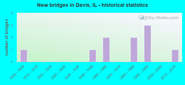
- New bridges - historical statistics
- 11900-1909
- 11950-1959
- 21960-1969
- 21980-1989
- 31990-1999
- 12010-2019


- Bridge Condition - Deck
- 33.3%Very good
- 33.3%Good
- 33.3%Satisfactory

- Bridge Condition - Superstructure
- 66.7%Very good
- 33.3%Good

- Bridge Condition - Substructure
- 33.3%Very good
- 66.7%Satisfactory

- Bridge Condition - Channel
- 11.1%Excellent
- 11.1%Very good
- 55.6%Good
- 22.2%Satisfactory

- Bridge Condition - Culverts
- 33.3%Very good
- 16.7%Good
- 33.3%Satisfactory
- 16.7%Fair
Find on map >> Show street view
Structure Number: 890084, Location: 1.3 MI E ROCK CITY (Lat: 42.417381, Lng: -89.442650), Route carried "on" structure: State highway 75, Year Built: 2011, Status: Open, Structure Length: 3.59m (11.78ft), Average Daily Traffic: 3,500 (year 2021), Truck Traffic: 7%, Average Future Daily Traffic: 3,600 (year 2040), Design Load: HS 20, Features Intersected: ROCK RUN CREEK
Minimum Vertical Clearance: 30+ m (98+ ft), Kilometerpoint: 23.962, Lanes on structure: 2, Base Highway Network: Yes, Owner: State Highway Agency, Approaching Roadway Width: 7.3m (24.0ft), Material/Design: Prestressed concrete continuous, Design/Construction: Stringer/Multi-beam, Number Of Spans In Main Unit: 2, Length of Maximum Span: 17.6m (57.7ft), Curb-To-Curb Width: 11.0m (36.1ft), Out-to-Out Width: 11.9m (39.0ft)
Condition: Deck: Satisfactory, Superstructure: Very good, Substructure: Satisfactory, Channel: Excellent, Operating Rating: 71.9 metric tons, Method Used To Determine Operating Rating: Load Factor (LF) rating reported by rating factor (RF) method using MS18 loading, Inventory Rating: 43.1 metric tons, Method Used To Determine Inventory Rating: Load Factor (LF) rating reported by rating factor (RF) method using MS18 loading, Structural Evaluation: Equal to present minimum criteria, Deck Geometry: Somewhat better than minimum adequacy, Waterway Adequacy: Equal to present desirable criteria, Approach Roadway Alignment: Equal to present desirable criteria, Designated Inspection Frequency: Every 24 months, Inspection Date: August 2020, Deck Structure Type: Concrete Cast-file-Place, Wearing Surface/Protective System: Deck Protection: Epoxy Coated Reinforcing
Find on map >> Show street view
Structure Number: 892013, Location: 0.5 MI. W. OF DAVIS (Lat: 42.418772, Lng: -89.431444), Route carried "on" structure: State highway 75, Year Built: 1996, Status: Open, Structure Length: 0.98m (3.22ft), Average Daily Traffic: 3,500 (year 2021), Truck Traffic: 7%, Average Future Daily Traffic: 3,713 (year 2040), Design Load: HS 20+Mod, Features Intersected: ROCK RUN CREEK
Minimum Vertical Clearance: 30+ m (98+ ft), Kilometerpoint: 24.912, Lanes on structure: 2, Base Highway Network: Yes, Owner: State Highway Agency, Approaching Roadway Width: 12.2m (40.0ft), Material/Design: Concrete, Design/Construction: Culvert, Number Of Spans In Main Unit: 3, Length of Maximum Span: 3.2m (10.5ft), Curb-To-Curb Width: 12.2m (40.0ft), Out-to-Out Width: 18.3m (60.0ft)
Condition: Channel: Good, Culverts: Good, Operating Rating: 56.1 metric tons, Method Used To Determine Operating Rating: Load Factor (LF) rating reported by rating factor (RF) method using MS18 loading, Inventory Rating: 33.7 metric tons, Method Used To Determine Inventory Rating: Load Factor (LF) rating reported by rating factor (RF) method using MS18 loading, Structural Evaluation: Better than present minimum criteria, Deck Geometry: Equal to present minimum criteria, Waterway Adequacy: Equal to present desirable criteria, Approach Roadway Alignment: Equal to present desirable criteria, Designated Inspection Frequency: Every 48 months, Inspection Date: October 2018
Find on map >> Show street view
Structure Number: 893193, Location: 1.2 M W OF DAVIS (Lat: 42.423611, Lng: -89.442661), Route carried "on" structure: County highway , Year Built: 1964, Status: Open, Structure Length: 1.65m (5.41ft), Average Daily Traffic: 50 (year 2014), Average Future Daily Traffic: 100 (year 2040), Design Load: HS 15, Features Intersected: ROCK RUN CREEK, Facility Carried by Structure: DEAN ROAD
Minimum Vertical Clearance: 30+ m (98+ ft), Kilometerpoint: 1.239, Lanes on structure: 2, Owner: Town or Township Highway Agency, Approaching Roadway Width: 4.9m (16.1ft), Material/Design: Prestressed concrete, Design/Construction: Box Beam or Girders - Multiple, Number Of Spans In Main Unit: 1, Length of Maximum Span: 16.2m (53.1ft), Curb-To-Curb Width: 6.4m (21.0ft), Out-to-Out Width: 6.7m (22.0ft)
Condition: Deck: Good, Superstructure: Good, Substructure: Satisfactory, Channel: Good, Operating Rating: 53.8 metric tons, Method Used To Determine Operating Rating: Load Factor (LF) rating reported by rating factor (RF) method using MS18 loading, Inventory Rating: 32.4 metric tons, Method Used To Determine Inventory Rating: Load Factor (LF) rating reported by rating factor (RF) method using MS18 loading, Structural Evaluation: Equal to present minimum criteria, Deck Geometry: Somewhat better than minimum adequacy, Waterway Adequacy: Better than present minimum criteria, Approach Roadway Alignment: Equal to present minimum criteria, Designated Inspection Frequency: Every 24 months, Inspection Date: October 2020, Deck Structure Type: Concrete Cast-file-Place, Wearing Surface/Protective System: Wearing Surface: Bituminous
Find on map >> Show street view
Structure Number: 893251, Location: .1 MI W FARWEL BR RD (Lat: 42.386925, Lng: -89.429419), Route carried "on" structure: County highway , Year Built: 1987, Status: Open, Structure Length: 3.35m (10.99ft), Average Daily Traffic: 25 (year 2014), Average Future Daily Traffic: 75 (year 2040), Design Load: HS 20, Features Intersected: ROCK RUN CREEK, Facility Carried by Structure: E KNAUP RD
Minimum Vertical Clearance: 30+ m (98+ ft), Kilometerpoint: 7.194, Lanes on structure: 2, Owner: Town or Township Highway Agency, Approaching Roadway Width: 7.3m (24.0ft), Skew: 2 degrees, Material/Design: Concrete, Design/Construction: Channel Beam, Number Of Spans In Main Unit: 3, Length of Maximum Span: 11.0m (36.1ft), Curb-To-Curb Width: 8.0m (26.2ft), Out-to-Out Width: 8.0m (26.2ft)
Condition: Deck: Very good, Superstructure: Very good, Substructure: Very good, Channel: Good, Operating Rating: 44.4 metric tons, Method Used To Determine Operating Rating: Assigned rating based on Load Factor Design (LFD) reported by rating factor (RF) using MS18 loading, Inventory Rating: 32.4 metric tons, Method Used To Determine Inventory Rating: Assigned rating based on Load Factor Design (LFD) reported by rating factor (RF) using MS18 loading, Structural Evaluation: Equal to present desirable criteria, Deck Geometry: Equal to present minimum criteria, Waterway Adequacy: Equal to present desirable criteria, Approach Roadway Alignment: Equal to present desirable criteria, Designated Inspection Frequency: Every 48 months, Inspection Date: October 2020, Deck Structure Type: Concrete Precast Panels, Wearing Surface/Protective System: Wearing Surface: Bituminous, Membrane: Built-up
Find on map >> Show street view
Structure Number: 895102, Location: 4 MI. S. OF DAVIS (Lat: 42.361072, Lng: -89.411814), Route carried "on" structure: County highway , Year Built: 1992, Year Reconstructed: 2006, Status: Open, Structure Length: 0.78m (2.56ft), Average Daily Traffic: 50 (year 2020), Average Future Daily Traffic: 50 (year 2040), Design Load: HS 20, Features Intersected: BR. OF PINK CREEK, Facility Carried by Structure: E. BRICK SCHOOL RD
Minimum Vertical Clearance: 30+ m (98+ ft), Kilometerpoint: 8.449, Lanes on structure: 2, Owner: Town or Township Highway Agency, Approaching Roadway Width: 6.1m (20.0ft), Material/Design: Concrete, Design/Construction: Culvert, Number Of Spans In Main Unit: 2, Length of Maximum Span: 4.0m (13.1ft)
Condition: Channel: Good, Culverts: Very good, Operating Rating: 44.1 metric tons, Method Used To Determine Operating Rating: Assigned rating based on Load Factor Design (LFD) reported by rating factor (RF) using MS18 loading, Inventory Rating: 32.4 metric tons, Method Used To Determine Inventory Rating: Assigned rating based on Load Factor Design (LFD) reported by rating factor (RF) using MS18 loading, Structural Evaluation: Equal to present desirable criteria, Waterway Adequacy: Equal to present desirable criteria, Approach Roadway Alignment: Equal to present desirable criteria, Designated Inspection Frequency: Every 48 months, Inspection Date: November 2018
Find on map >> Show street view
Structure Number: 895118, Location: 0.5 MI S. OF IL 75 (Lat: 42.410778, Lng: -89.437783), Route carried "on" structure: County highway , Year Built: 1996, Status: Open, Structure Length: 0.74m (2.43ft), Average Daily Traffic: 50 (year 2019), Average Future Daily Traffic: 50 (year 2040), Design Load: HS 20, Features Intersected: BR, ROCK RUN CREEK, Facility Carried by Structure: N. CHURCH ROAD
Minimum Vertical Clearance: 30+ m (98+ ft), Kilometerpoint: 0.869, Lanes on structure: 2, Owner: Town or Township Highway Agency, Approaching Roadway Width: 4.9m (16.1ft), Material/Design: Concrete, Design/Construction: Culvert, Number Of Spans In Main Unit: 2, Length of Maximum Span: 3.4m (11.2ft)
Condition: Channel: Very good, Culverts: Very good, Operating Rating: 44.1 metric tons, Method Used To Determine Operating Rating: Assigned rating based on Load Factor Design (LFD) reported by rating factor (RF) using MS18 loading, Inventory Rating: 32.4 metric tons, Method Used To Determine Inventory Rating: Assigned rating based on Load Factor Design (LFD) reported by rating factor (RF) using MS18 loading, Structural Evaluation: Equal to present desirable criteria, Waterway Adequacy: Equal to present desirable criteria, Approach Roadway Alignment: Better than present minimum criteria, Designated Inspection Frequency: Every 48 months, Inspection Date: November 2018
Find on map >> Show street view
Structure Number: 1015052, Location: 0.2 MI W BEST ROAD (Lat: 42.404164, Lng: -89.385094), Route carried "on" structure: County highway , Year Built: 1963, Status: Open, Structure Length: 0.72m (2.36ft), Average Daily Traffic: 50 (year 2017), Average Future Daily Traffic: 75 (year 2040), Design Load: H 20, Features Intersected: BRANCH OF PINK CREEK, Facility Carried by Structure: FARM SCHOOL ROAD
Minimum Vertical Clearance: 30+ m (98+ ft), Kilometerpoint: 1.110, Lanes on structure: 2, Owner: Town or Township Highway Agency, Approaching Roadway Width: 9.1m (29.9ft), Material/Design: Concrete, Design/Construction: Culvert, Number Of Spans In Main Unit: 2, Length of Maximum Span: 3.4m (11.2ft)
Condition: Channel: Good, Culverts: Fair, Operating Rating: 60.3 metric tons, Method Used To Determine Operating Rating: Load Factor (LF) rating reported by rating factor (RF) method using MS18 loading, Inventory Rating: 36.3 metric tons, Method Used To Determine Inventory Rating: Load Factor (LF) rating reported by rating factor (RF) method using MS18 loading, Structural Evaluation: Somewhat better than minimum adequacy, Waterway Adequacy: Better than present minimum criteria, Approach Roadway Alignment: Equal to present desirable criteria, Designated Inspection Frequency: Every 24 months, Inspection Date: May 2020
Find on map >> Show street view
Structure Number: 1015101, Location: 0.2 MI E COUNTY LINE (Lat: 42.375192, Lng: -89.393114), Route carried "on" structure: County highway , Year Built: 1983, Status: Open, Structure Length: 0.79m (2.59ft), Average Daily Traffic: 900 (year 2017), Truck Traffic: 3%, Average Future Daily Traffic: 1,100 (year 2040), Design Load: HS 20, Features Intersected: UNNAMED CREEK, Facility Carried by Structure: TRASK BRIDGE ROAD
Minimum Vertical Clearance: 30+ m (98+ ft), Kilometerpoint: 0.402, Lanes on structure: 2, Owner: County Highway Agency, Approaching Roadway Width: 11.0m (36.1ft), Material/Design: Concrete, Design/Construction: Culvert, Number Of Spans In Main Unit: 2, Length of Maximum Span: 3.7m (12.1ft), Curb-To-Curb Width: 11.0m (36.1ft), Out-to-Out Width: 11.6m (38.1ft)
Condition: Channel: Satisfactory, Culverts: Satisfactory, Operating Rating: 74.8 metric tons, Method Used To Determine Operating Rating: Load Factor (LF) rating reported by rating factor (RF) method using MS18 loading, Inventory Rating: 46.3 metric tons, Method Used To Determine Inventory Rating: Load Factor (LF) rating reported by rating factor (RF) method using MS18 loading, Structural Evaluation: Equal to present minimum criteria, Deck Geometry: Better than present minimum criteria, Waterway Adequacy: Equal to present minimum criteria, Approach Roadway Alignment: Equal to present desirable criteria, Designated Inspection Frequency: Every 24 months, Inspection Date: April 2021
Find on map >> Show street view
Structure Number: 1015126, Location: 0.7 M E OF CO. LINE (Lat: 42.389714, Lng: -89.384572), Route carried "on" structure: County highway , Year Built: 1951, Status: Open, Structure Length: 0.66m (2.17ft), Average Daily Traffic: 75 (year 2017), Average Future Daily Traffic: 200 (year 2040), Design Load: H 15, Features Intersected: N. BR. PINK CR., Facility Carried by Structure: CAMPBELL ROAD
Minimum Vertical Clearance: 30+ m (98+ ft), Kilometerpoint: 1.127, Lanes on structure: 2, Owner: Town or Township Highway Agency, Approaching Roadway Width: 7.9m (25.9ft), Material/Design: Concrete, Design/Construction: Culvert, Number Of Spans In Main Unit: 2, Length of Maximum Span: 3.0m (9.8ft)
Condition: Channel: Satisfactory, Culverts: Satisfactory, Operating Rating: 22.7 metric tons, Method Used To Determine Operating Rating: Field evaluation and documented engineering judgment, Inventory Rating: 13.6 metric tons, Method Used To Determine Inventory Rating: Field evaluation and documented engineering judgment, Structural Evaluation: Meets minimum limits, Waterway Adequacy: Better than present minimum criteria, Approach Roadway Alignment: Equal to present desirable criteria, Bridge Posting: Required (Relationship of Operating Rating to Maximum Legal Load: > 39.9% below), Designated Inspection Frequency: Every 24 months, Inspection Date: May 2020
Find on map >> Show street view
Structure Number: 1019929, Location: .5 MI N OF ILL 75 (Lat: 42.424489, Lng: -89.399050), Route carried "under" structure: County highway , Year Built: 1900, Structure Length: 0. m, Average Daily Traffic: 25 (year 2017), Features Intersected: GOEKE RD, Facility Carried by Structure: CMST P&P RR
Minimum Vertical Clearance: 7.54m (24.74ft), Kilometerpoint: 1.722, Lanes under structure: 2, Material/Design: Steel, Design/Construction: Box Beam or Girders - Multiple, Length of Maximum Span: 10.4m (34.1ft)