Bridge Statistics for Dauphin, Pennsylvania (PA)
Condition, Traffic, Stress, Structural Evaluation, Project Costs
- National Bridge Inventory (NBI) Statistics
- 25Number of bridges
- 187ft / 57.4mTotal length
- $1,567,000Total costs
- 254,614Total average daily traffic
- 38,840Total average daily truck traffic
- National Bridge Inventory (NBI) Registered Bridges for Dauphin
- No street view available for this location
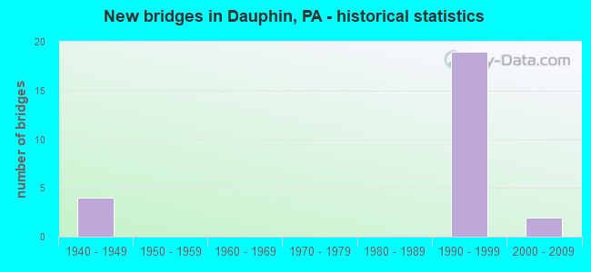
- New bridges - historical statistics
- 41940-1949
- 191990-1999
- 22000-2009


- Bridge Condition - Deck
- 69.2%Good
- 23.1%Satisfactory
- 7.7%Fair

- Bridge Condition - Superstructure
- 35.7%Very good
- 35.7%Good
- 7.1%Satisfactory
- 21.4%Fair

- Bridge Condition - Substructure
- 78.6%Good
- 7.1%Satisfactory
- 14.3%Fair

- Bridge Condition - Channel
- 16.7%Very good
- 50.0%Satisfactory
- 33.3%Fair
Find on map >> Show street view
Structure Number: 14158, Location: 200 FT NW OF SR 0322 (Lat: 40.365536, Lng: -76.929189), Route carried "on" structure: ServiceCity street , Year Built: 1942, Status: Open, Structure Length: 0.85m (2.79ft), Average Daily Traffic: 1,000 (year 2021), Average Future Daily Traffic: 1,000 (year 2041), Features Intersected: SUSQUEHANNA STREET, Facility Carried by Structure: ALLEGHENY STREET
Minimum Vertical Clearance: 30+ m (98+ ft), Kilometerpoint: 0.000, Lanes on structure: 3, Lanes under structure: 2, Owner: City or Municipal Highway Agency, Approaching Roadway Width: 15.2m (49.9ft), Material/Design: Concrete, Design/Construction: Tee Beam, Number Of Spans In Main Unit: 1, Length of Maximum Span: 7.0m (23.0ft), Curb or Sidewalk Widths: Left: 1.2m (3.9ft), Right: 1.2m (3.9ft), Curb-To-Curb Width: 15.0m (49.2ft), Out-to-Out Width: 18.3m (60.0ft)
Condition: Deck: Fair, Superstructure: Fair, Substructure: Fair, Operating Rating: 68.9 metric tons, Method Used To Determine Operating Rating: Load Factor (LF), Inventory Rating: 41.7 metric tons, Method Used To Determine Inventory Rating: Load Factor (LF), Structural Evaluation: Somewhat better than minimum adequacy, Deck Geometry: Equal to present minimum criteria, Underclear: High priority of corrective action, Approach Roadway Alignment: Equal to present desirable criteria, Length Of Structure Improvement: 1.50m (4.92ft), Designated Inspection Frequency: Every 24 months, Inspection Date: June 2021, Bridge Improvement Cost: $24,000, Roadway Improvement Cost: $70,000, Total Project Cost: $322,000, Deck Structure Type: Concrete Cast-file-Place, Wearing Surface/Protective System: Wearing Surface: Bituminous, Membrane: Preformed Fabric
Find on map >> Show street view
Structure Number: 14159, Location: 200 FT NW OF SR 0322 (Lat: 40.365047, Lng: -76.928542), Route carried "on" structure: City street , Year Built: 1942, Status: Open, Structure Length: 1.52m (4.99ft), Average Daily Traffic: 1,000 (year 2021), Average Future Daily Traffic: 1,000 (year 2041), Features Intersected: STONY CREEK, Facility Carried by Structure: ALLEGHENY STREET
Minimum Vertical Clearance: 30+ m (98+ ft), Kilometerpoint: 0.000, Lanes on structure: 3, Owner: City or Municipal Highway Agency, Approaching Roadway Width: 15.2m (49.9ft), Material/Design: Concrete, Design/Construction: Arch - Deck, Number Of Spans In Main Unit: 1, Length of Maximum Span: 15.2m (49.9ft), Curb or Sidewalk Widths: Left: 1.2m (3.9ft), Right: 1.2m (3.9ft), Curb-To-Curb Width: 15.2m (49.9ft), Out-to-Out Width: 18.3m (60.0ft)
Condition: Superstructure: Fair, Substructure: Fair, Channel: Fair, Operating Rating: 65.3 metric tons, Method Used To Determine Operating Rating: Field evaluation and documented engineering judgment, Inventory Rating: 39.0 metric tons, Method Used To Determine Inventory Rating: Field evaluation and documented engineering judgment, Structural Evaluation: Somewhat better than minimum adequacy, Deck Geometry: Equal to present minimum criteria, Waterway Adequacy: Superior to present desirable criteria, Approach Roadway Alignment: Equal to present desirable criteria, Length Of Structure Improvement: 2.20m (7.22ft), Designated Inspection Frequency: Every 24 months, Inspection Date: June 2021
Find on map >> Show street view
Structure Number: 14315, Location: 1MI N OF DAUPHIN (Lat: 40.388167, Lng: -76.941858), Route carried "on" structure: State highway 225, Year Built: 1995, Status: Open, Structure Length: 3.96m (12.99ft), Average Daily Traffic: 10,876 (year 2022), Truck Traffic: 1%, Average Future Daily Traffic: 14,848 (year 2032), Design Load: HS 25 or greater, Features Intersected: CLARKS CREEK
Minimum Vertical Clearance: 30+ m (98+ ft), Kilometerpoint: 2.535, Lanes on structure: 2, Owner: State Highway Agency, Approaching Roadway Width: 13.4m (44.0ft), Skew: 3 degrees, Material/Design: Prestressed concrete, Design/Construction: Box Beam or Girders - Single/Spread, Number Of Spans In Main Unit: 2, Length of Maximum Span: 19.5m (64.0ft), Curb or Sidewalk Widths: Left: 0.2m (0.7ft), Right: 0.2m (0.7ft), Curb-To-Curb Width: 13.4m (44.0ft), Out-to-Out Width: 14.5m (47.6ft)
Condition: Deck: Satisfactory, Superstructure: Good, Substructure: Good, Channel: Satisfactory, Operating Rating: 98.9 metric tons, Method Used To Determine Operating Rating: Load Factor (LF), Inventory Rating: 51.7 metric tons, Method Used To Determine Inventory Rating: Load Factor (LF), Structural Evaluation: Better than present minimum criteria, Deck Geometry: Equal to present minimum criteria, Waterway Adequacy: Equal to present minimum criteria, Approach Roadway Alignment: Equal to present desirable criteria, Length Of Structure Improvement: 4.70m (15.42ft), Designated Inspection Frequency: Every 24 months, Inspection Date: October 2020, Deck Structure Type: Concrete Cast-file-Place, Wearing Surface/Protective System: Wearing Surface: Monolithic Concrete, Deck Protection: Epoxy Coated Reinforcing
Find on map >> Show street view
Structure Number: 14377, Location: 3 MI. N.E. DAUPHIN (Lat: 40.404058, Lng: -76.912058), Route carried "on" structure: State highway 325, Year Built: 1941, Year Reconstructed: 1981, Status: Open, Structure Length: 2.13m (6.99ft), Average Daily Traffic: 758 (year 2021), Truck Traffic: 13%, Average Future Daily Traffic: 1,200 (year 2032), Design Load: HS 20, Features Intersected: CLARKS CREEK
Minimum Vertical Clearance: 30+ m (98+ ft), Kilometerpoint: 8.438, Lanes on structure: 2, Owner: State Highway Agency, Approaching Roadway Width: 7.3m (24.0ft), Skew: 3 degrees, Material/Design: Steel, Design/Construction: Stringer/Multi-beam, Number Of Spans In Main Unit: 2, Length of Maximum Span: 9.8m (32.2ft), Curb-To-Curb Width: 7.3m (24.0ft), Out-to-Out Width: 7.7m (25.3ft)
Condition: Deck: Good, Superstructure: Fair, Substructure: Satisfactory, Channel: Satisfactory, Operating Rating: 55.3 metric tons, Method Used To Determine Operating Rating: Load Factor (LF), Inventory Rating: 33.6 metric tons, Method Used To Determine Inventory Rating: Load Factor (LF), Structural Evaluation: Somewhat better than minimum adequacy, Deck Geometry: Meets minimum limits, Waterway Adequacy: Superior to present desirable criteria, Approach Roadway Alignment: Equal to present desirable criteria, Length Of Structure Improvement: 2.80m (9.19ft), Designated Inspection Frequency: Every 24 months, Inspection Date: October 2020, Bridge Improvement Cost: $60,000, Roadway Improvement Cost: $175,000, Total Project Cost: $804,000, Deck Structure Type: Closed Grating, Wearing Surface/Protective System: Wearing Surface: Bituminous, Membrane: Preformed Fabric
Find on map >> Show street view
Structure Number: 14378, Location: 3.5 MI. N.E. DAUPHIN (Lat: 40.406042, Lng: -76.908253), Route carried "on" structure: State highway 325, Year Built: 1993, Status: Open, Structure Length: 3.11m (10.20ft), Average Daily Traffic: 758 (year 2021), Truck Traffic: 13%, Average Future Daily Traffic: 1,200 (year 2032), Design Load: HS 20, Features Intersected: CLARKS CREEK
Minimum Vertical Clearance: 30+ m (98+ ft), Kilometerpoint: 9.125, Lanes on structure: 2, Owner: State Highway Agency, Approaching Roadway Width: 10.1m (33.1ft), Skew: 1 degrees, Material/Design: Prestressed concrete, Design/Construction: Box Beam or Girders - Multiple, Number Of Spans In Main Unit: 2, Length of Maximum Span: 15.2m (49.9ft), Curb or Sidewalk Widths: Left: 0.2m (0.7ft), Right: 0.2m (0.7ft), Curb-To-Curb Width: 10.1m (33.1ft), Out-to-Out Width: 11.1m (36.4ft)
Condition: Deck: Good, Superstructure: Good, Substructure: Good, Channel: Satisfactory, Inventory Rating: 61.7 metric tons, Method Used To Determine Inventory Rating: Load Factor (LF), Structural Evaluation: Better than present minimum criteria, Deck Geometry: Equal to present minimum criteria, Waterway Adequacy: Equal to present minimum criteria, Approach Roadway Alignment: Equal to present desirable criteria, Length Of Structure Improvement: 4.00m (13.12ft), Designated Inspection Frequency: Every 24 months, Inspection Date: October 2020, Deck Structure Type: Concrete Cast-file-Place, Wearing Surface/Protective System: Wearing Surface: Monolithic Concrete, Deck Protection: Epoxy Coated Reinforcing
Find on map >> Show street view
Structure Number: 14691, Location: 1E DAUPH BORO/STONEY CRK (Lat: 40.377900, Lng: -76.911622), Route carried "on" structure: City street , Year Built: 1998, Status: Open, Structure Length: 2.07m (6.79ft), Average Daily Traffic: 50 (year 2021), Truck Traffic: 1%, Average Future Daily Traffic: 350 (year 2041), Design Load: HS 25 or greater, Features Intersected: STONEY CREEK, Facility Carried by Structure: SINGER LANE
Minimum Vertical Clearance: 30+ m (98+ ft), Kilometerpoint: 0.000, Lanes on structure: 2, Owner: County Highway Agency, Approaching Roadway Width: 7.3m (24.0ft), Material/Design: Prestressed concrete, Design/Construction: Box Beam or Girders - Single/Spread, Number Of Spans In Main Unit: 1, Length of Maximum Span: 20.4m (66.9ft), Curb or Sidewalk Widths: Left: 0.2m (0.7ft), Right: 0.2m (0.7ft), Curb-To-Curb Width: 7.3m (24.0ft), Out-to-Out Width: 8.4m (27.6ft)
Condition: Deck: Good, Superstructure: Satisfactory, Substructure: Good, Channel: Fair, Operating Rating: 81.6 metric tons, Method Used To Determine Operating Rating: Load Factor (LF), Inventory Rating: 40.8 metric tons, Method Used To Determine Inventory Rating: Load Factor (LF), Structural Evaluation: Equal to present minimum criteria, Deck Geometry: Equal to present minimum criteria, Waterway Adequacy: Equal to present desirable criteria, Approach Roadway Alignment: Equal to present desirable criteria, Length Of Structure Improvement: 2.00m (6.56ft), Designated Inspection Frequency: Every 24 months, Inspection Date: June 2021, Bridge Improvement Cost: $33,000, Roadway Improvement Cost: $151,000, Total Project Cost: $441,000, Deck Structure Type: Concrete Cast-file-Place, Wearing Surface/Protective System: Wearing Surface: Monolithic Concrete
Find on map >> Show street view
Structure Number: 41037, Location: DAUPHIN BORO (Lat: 40.364244, Lng: -76.928564), Route carried "on" structure: US 22, Year Built: 1999, Status: Open, Structure Length: 6.16m (20.21ft), Average Daily Traffic: 42,678 (year 2021), Truck Traffic: 17%, Average Future Daily Traffic: 76,094 (year 2032), Design Load: HS 25 or greater, Features Intersected: STONY CREEK
Minimum Vertical Clearance: 30+ m (98+ ft), Kilometerpoint: 13.436, Lanes on structure: 4, Base Highway Network: Yes, Owner: State Highway Agency, Approaching Roadway Width: 25.6m (84.0ft), Skew: 31 degrees, Material/Design: Prestressed concrete, Design/Construction: Box Beam or Girders - Single/Spread, Number Of Spans In Main Unit: 3, Length of Maximum Span: 20.1m (65.9ft), Curb or Sidewalk Widths: Left: 0.2m (0.7ft), Right: 0.2m (0.7ft), Curb-To-Curb Width: 26.2m (86.0ft), Out-to-Out Width: 27.7m (90.9ft)
Condition: Deck: Satisfactory, Superstructure: Good, Substructure: Good, Channel: Very good, Operating Rating: 81.6 metric tons, Method Used To Determine Operating Rating: Load Factor (LF), Inventory Rating: 48.1 metric tons, Method Used To Determine Inventory Rating: Load Factor (LF), Structural Evaluation: Better than present minimum criteria, Deck Geometry: Superior to present desirable criteria, Waterway Adequacy: Superior to present desirable criteria, Approach Roadway Alignment: Better than present minimum criteria, Length Of Structure Improvement: 7.10m (23.29ft), Designated Inspection Frequency: Every 24 months, Inspection Date: October 2020, Deck Structure Type: Concrete Cast-file-Place, Wearing Surface/Protective System: Wearing Surface: Monolithic Concrete, Deck Protection: Epoxy Coated Reinforcing
Find on map >> Show street view
Structure Number: 41038, Location: WEST OF DAUPHIN BORO (Lat: 40.371072, Lng: -76.944403), Route carried "on" structure: Bypass State highway , Year Built: 1999, Status: Open, Structure Length: 3.57m (11.71ft), Average Daily Traffic: 2,900 (year 2022), Truck Traffic: 5%, Average Future Daily Traffic: 3,799 (year 2032), Design Load: HS 25 or greater, Features Intersected: RAMP A, Facility Carried by Structure: SR 3035
Minimum Vertical Clearance: 30+ m (98+ ft), Kilometerpoint: 0.000, Lanes on structure: 2, Lanes under structure: 1, Owner: State Highway Agency, Approaching Roadway Width: 14.9m (48.9ft), Skew: 9 degrees, Material/Design: Prestressed concrete, Design/Construction: Box Beam or Girders - Single/Spread, Number Of Spans In Main Unit: 3, Length of Maximum Span: 17.7m (58.1ft), Curb-To-Curb Width: 15.0m (49.2ft), Out-to-Out Width: 16.0m (52.5ft)
Condition: Deck: Good, Superstructure: Good, Substructure: Good, Operating Rating: 83.5 metric tons, Method Used To Determine Operating Rating: Load Factor (LF), Inventory Rating: 46.3 metric tons, Method Used To Determine Inventory Rating: Load Factor (LF), Structural Evaluation: Better than present minimum criteria, Deck Geometry: Superior to present desirable criteria, Underclear: Better than present minimum criteria, Approach Roadway Alignment: Equal to present desirable criteria, Length Of Structure Improvement: 4.50m (14.76ft), Designated Inspection Frequency: Every 24 months, Inspection Date: October 2020, Deck Structure Type: Concrete Cast-file-Place, Wearing Surface/Protective System: Wearing Surface: Monolithic Concrete, Deck Protection: Epoxy Coated Reinforcing
Find on map >> Show street view
Structure Number: 41039, Location: WEST OF DAUPHIN (Lat: 40.370753, Lng: -76.942839), Route carried "on" structure: Bypass State highway , Year Built: 1999, Status: Open, Structure Length: 3.90m (12.80ft), Average Daily Traffic: 2,900 (year 2022), Truck Traffic: 5%, Average Future Daily Traffic: 3,799 (year 2032), Design Load: HS 25 or greater, Features Intersected: RAMP D, Facility Carried by Structure: SR 3035
Minimum Vertical Clearance: 30+ m (98+ ft), Kilometerpoint: 0.000, Lanes on structure: 3, Lanes under structure: 2, Owner: State Highway Agency, Approaching Roadway Width: 14.9m (48.9ft), Skew: 9 degrees, Material/Design: Prestressed concrete, Design/Construction: Box Beam or Girders - Single/Spread, Number Of Spans In Main Unit: 3, Length of Maximum Span: 20.4m (66.9ft), Curb-To-Curb Width: 15.0m (49.2ft), Out-to-Out Width: 16.0m (52.5ft)
Condition: Deck: Good, Superstructure: Good, Substructure: Good, Operating Rating: 72.6 metric tons, Method Used To Determine Operating Rating: Load Factor (LF), Inventory Rating: 43.5 metric tons, Method Used To Determine Inventory Rating: Load Factor (LF), Structural Evaluation: Better than present minimum criteria, Deck Geometry: Equal to present minimum criteria, Underclear: Superior to present desirable criteria, Approach Roadway Alignment: Equal to present desirable criteria, Length Of Structure Improvement: 5.00m (16.40ft), Designated Inspection Frequency: Every 24 months, Inspection Date: October 2020, Deck Structure Type: Concrete Cast-file-Place, Wearing Surface/Protective System: Wearing Surface: Monolithic Concrete, Deck Protection: Epoxy Coated Reinforcing
Find on map >> Show street view
Structure Number: 4104, Location: WEST OF DAUPHIN (Lat: 40.370217, Lng: -76.947772), Route carried "on" structure: Ramp State highway , Year Built: 1999, Status: Open, Structure Length: 9.91m (32.51ft), Average Daily Traffic: 424 (year 2022), Truck Traffic: 8%, Average Future Daily Traffic: 424 (year 2032), Design Load: HS 25 or greater, Features Intersected: US 22/322, Facility Carried by Structure: SR 8045 RAMP C
Minimum Vertical Clearance: 30+ m (98+ ft), Kilometerpoint: 0.000, Lanes on structure: 1, Lanes under structure: 8, Base Highway Network: Yes, Owner: State Highway Agency, Approaching Roadway Width: 10.1m (33.1ft), Skew: 9 degrees, Material/Design: Steel continuous, Design/Construction: Stringer/Multi-beam, Number Of Spans In Main Unit: 2, Length of Maximum Span: 53.3m (174.9ft), Curb-To-Curb Width: 10.1m (33.1ft), Out-to-Out Width: 11.1m (36.4ft)
Condition: Deck: Satisfactory, Superstructure: Very good, Substructure: Good, Operating Rating: 72.6 metric tons, Method Used To Determine Operating Rating: Load Factor (LF), Inventory Rating: 43.5 metric tons, Method Used To Determine Inventory Rating: Load Factor (LF), Structural Evaluation: Better than present minimum criteria, Deck Geometry: Superior to present desirable criteria, Underclear: Meets minimum limits, Approach Roadway Alignment: Equal to present desirable criteria, Length Of Structure Improvement: 10.90m (35.76ft), Designated Inspection Frequency: Every 24 months, Inspection Date: October 2020, Deck Structure Type: Concrete Cast-file-Place, Wearing Surface/Protective System: Wearing Surface: Monolithic Concrete, Deck Protection: Epoxy Coated Reinforcing
Find on map >> Show street view
Structure Number: 41041, Location: WEST OF DAUPHIN BORO (Lat: 40.372214, Lng: -76.942222), Route carried "on" structure: Ramp State highway , Year Built: 1999, Status: Open, Structure Length: 8.63m (28.31ft), Average Daily Traffic: 4,178 (year 2022), Truck Traffic: 8%, Average Future Daily Traffic: 9,044 (year 2032), Design Load: HS 25 or greater, Features Intersected: US 22/322, Facility Carried by Structure: RAMP D
Minimum Vertical Clearance: 30+ m (98+ ft), Kilometerpoint: 0.000, Lanes on structure: 2, Lanes under structure: 8, Base Highway Network: Yes, Owner: State Highway Agency, Approaching Roadway Width: 12.8m (42.0ft), Skew: 9 degrees, Material/Design: Steel continuous, Design/Construction: Stringer/Multi-beam, Number Of Spans In Main Unit: 2, Length of Maximum Span: 46.0m (150.9ft), Curb or Sidewalk Widths: Left: 0.2m (0.7ft), Right: 0.2m (0.7ft), Curb-To-Curb Width: 12.8m (42.0ft), Out-to-Out Width: 13.9m (45.6ft)
Condition: Deck: Good, Superstructure: Very good, Substructure: Good, Operating Rating: 68.0 metric tons, Method Used To Determine Operating Rating: Load Factor (LF), Inventory Rating: 40.8 metric tons, Method Used To Determine Inventory Rating: Load Factor (LF), Structural Evaluation: Better than present minimum criteria, Deck Geometry: Superior to present desirable criteria, Underclear: Meets minimum limits, Approach Roadway Alignment: Better than present minimum criteria, Length Of Structure Improvement: 9.70m (31.82ft), Designated Inspection Frequency: Every 24 months, Inspection Date: October 2020, Deck Structure Type: Concrete Cast-file-Place, Wearing Surface/Protective System: Wearing Surface: Monolithic Concrete, Deck Protection: Epoxy Coated Reinforcing
Find on map >> Show street view
Structure Number: 41052, Location: WEST OF DAUPHIN (Lat: 40.370394, Lng: -76.950400), Route carried "on" structure: State highway , Year Built: 1999, Status: Open, Structure Length: 7.16m (23.49ft), Average Daily Traffic: 231 (year 2017), Truck Traffic: 3%, Average Future Daily Traffic: 409 (year 2032), Design Load: HS 25 or greater, Features Intersected: US 22/322, NS RAILROAD, Facility Carried by Structure: HAGY LANE
Minimum Vertical Clearance: 30+ m (98+ ft), Kilometerpoint: 0.000, Lanes on structure: 2, Lanes under structure: 7, Owner: State Highway Agency, Approaching Roadway Width: 8.5m (27.9ft), Material/Design: Steel continuous, Design/Construction: Stringer/Multi-beam, Number Of Spans In Main Unit: 2, Length of Maximum Span: 36.6m (120.1ft), Curb or Sidewalk Widths: Left: 0.2m (0.7ft), Right: 0.2m (0.7ft), Curb-To-Curb Width: 8.5m (27.9ft), Out-to-Out Width: 9.6m (31.5ft)
Condition: Deck: Good, Superstructure: Very good, Substructure: Good, Operating Rating: 74.4 metric tons, Method Used To Determine Operating Rating: Load Factor (LF), Inventory Rating: 44.5 metric tons, Method Used To Determine Inventory Rating: Load Factor (LF), Structural Evaluation: Better than present minimum criteria, Deck Geometry: Equal to present minimum criteria, Underclear: Meets minimum limits, Approach Roadway Alignment: Better than present minimum criteria, Length Of Structure Improvement: 8.10m (26.57ft), Designated Inspection Frequency: Every 24 months, Inspection Date: August 2020, Deck Structure Type: Concrete Cast-file-Place, Wearing Surface/Protective System: Wearing Surface: Monolithic Concrete, Deck Protection: Epoxy Coated Reinforcing
Find on map >> Show street view
Structure Number: 41053, Location: DAUPHIN BORO (Lat: 40.365944, Lng: -76.933731), Route carried "on" structure: US 22, Year Built: 1999, Status: Open, Structure Length: 1.83m (6.00ft), Average Daily Traffic: 42,678 (year 2021), Truck Traffic: 17%, Average Future Daily Traffic: 76,094 (year 2032), Design Load: HS 20+Mod, Features Intersected: MARKET STREET
Minimum Vertical Clearance: 30+ m (98+ ft), Kilometerpoint: 12.577, Lanes on structure: 2, Lanes under structure: 2, Base Highway Network: Yes, Owner: State Highway Agency, Approaching Roadway Width: 25.0m (82.0ft), Skew: 30 degrees, Material/Design: Prestressed concrete, Design/Construction: Box Beam or Girders - Single/Spread, Number Of Spans In Main Unit: 1, Length of Maximum Span: 18.3m (60.0ft), Curb-To-Curb Width: 25.0m (82.0ft), Out-to-Out Width: 27.8m (91.2ft)
Condition: Deck: Good, Superstructure: Very good, Substructure: Good, Inventory Rating: 48.1 metric tons, Method Used To Determine Inventory Rating: Load Factor (LF), Structural Evaluation: Better than present minimum criteria, Deck Geometry: Superior to present desirable criteria, Underclear: High priority of corrective action, Approach Roadway Alignment: Equal to present desirable criteria, Length Of Structure Improvement: 2.70m (8.86ft), Designated Inspection Frequency: Every 24 months, Inspection Date: October 2020, Deck Structure Type: Concrete Cast-file-Place, Wearing Surface/Protective System: Wearing Surface: Monolithic Concrete, Deck Protection: Epoxy Coated Reinforcing
Find on map >> Show street view
Structure Number: 44005, Location: CITY ISLAND (Lat: 40.254558, Lng: -76.886678), Route carried "on" structure: State highway , Year Built: 2006, Status: Open, Structure Length: 2.59m (8.50ft), Average Daily Traffic: 13,611 (year 2022), Truck Traffic: 1%, Average Future Daily Traffic: 33,016 (year 2032), Design Load: HS 20, Features Intersected: Riverside Dr. (City Is.), Facility Carried by Structure: SR 3012 Market St.
Minimum Vertical Clearance: 30+ m (98+ ft), Kilometerpoint: 0.435, Lanes on structure: 4, Lanes under structure: 2, Base Highway Network: Yes, Owner: State Highway Agency, Approaching Roadway Width: 7.3m (24.0ft), Material/Design: Prestressed concrete, Design/Construction: Box Beam or Girders - Single/Spread, Number Of Spans In Main Unit: 1, Length of Maximum Span: 22.9m (75.1ft), Curb or Sidewalk Widths: Left: 2.1m (6.9ft), Right: 2.1m (6.9ft), Curb-To-Curb Width: 7.3m (24.0ft), Out-to-Out Width: 18.9m (62.0ft)
Condition: Deck: Good, Superstructure: Very good, Substructure: Good, Operating Rating: 78.0 metric tons, Method Used To Determine Operating Rating: Load Factor (LF), Inventory Rating: 36.3 metric tons, Method Used To Determine Inventory Rating: Load Factor (LF), Structural Evaluation: Better than present minimum criteria, Deck Geometry: High priority of replacement, Underclear: High priority of corrective action, Approach Roadway Alignment: Equal to present desirable criteria, Designated Inspection Frequency: Every 24 months, Inspection Date: August 2020, Deck Structure Type: Concrete Cast-file-Place, Wearing Surface/Protective System: Wearing Surface: Monolithic Concrete, Deck Protection: Epoxy Coated Reinforcing
Find on map >> Show street view
Structure Number: 14158, Location: 200 FT NW OF SR 0322 (Lat: 40.365536, Lng: -76.929189), Route carried "under" structure: ServiceCity street , Year Built: 1942, Structure Length: 0. m, Average Daily Traffic: 10 (year 2011), Features Intersected: SUSQUEHANNA STREET, Facility Carried by Structure: ALLEGHENY STREET
Minimum Vertical Clearance: 4.19m (13.75ft), Kilometerpoint: 0.000, Lanes on structure: 3, Lanes under structure: 2, Material/Design: Concrete, Design/Construction: Tee Beam, Length of Maximum Span: 7.0m (23.0ft)
Find on map >> Show street view
Structure Number: 41038, Location: WEST OF DAUPHIN BORO (Lat: 40.371072, Lng: -76.944403), Route carried "under" structure: Ramp State highway , Year Built: 1999, Structure Length: 0. m, Average Daily Traffic: 2,485 (year 2022), Truck Traffic: 8%, Features Intersected: RAMP A, Facility Carried by Structure: SR 3035
Minimum Vertical Clearance: 5.13m (16.83ft), Kilometerpoint: 0.000, Lanes on structure: 2, Lanes under structure: 1, Material/Design: Prestressed concrete, Design/Construction: Box Beam or Girders - Single/Spread, Length of Maximum Span: 17.7m (58.1ft)
Find on map >> Show street view
Structure Number: 41039, Location: WEST OF DAUPHIN (Lat: 40.370753, Lng: -76.942839), Route carried "under" structure: Bypass State highway , Year Built: 1999, Structure Length: 0. m, Average Daily Traffic: 4,178 (year 2022), Truck Traffic: 8%, Features Intersected: RAMP D, Facility Carried by Structure: SR 3035
Minimum Vertical Clearance: 5.79m (19.00ft), Kilometerpoint: 0.000, Lanes on structure: 3, Lanes under structure: 2, Material/Design: Prestressed concrete, Design/Construction: Box Beam or Girders - Single/Spread, Length of Maximum Span: 20.4m (66.9ft)
Find on map >> Show street view
Structure Number: 4104, Location: WEST OF DAUPHIN (Lat: 40.370217, Lng: -76.947772), Route carried "under" structure: US 22, Year Built: 1999, Structure Length: 0. m, Average Daily Traffic: 21,711 (year 2021), Truck Traffic: 15%, Features Intersected: US 22/322, Facility Carried by Structure: SR 8045 RAMP C
Minimum Vertical Clearance: 6.48m (21.26ft), Kilometerpoint: 11.890, Lanes on structure: 1, Lanes under structure: 4, Material/Design: Steel continuous, Design/Construction: Stringer/Multi-beam, Length of Maximum Span: 53.3m (174.9ft)
Find on map >> Show street view
Structure Number: 4104, Location: WEST OF DAUPHIN (Lat: 40.370217, Lng: -76.947772), Route carried "under" structure: US 22, Year Built: 1999, Structure Length: 0. m, Average Daily Traffic: 20,967 (year 2021), Truck Traffic: 19%, Features Intersected: US 22/322, Facility Carried by Structure: SR 8045 RAMP C
Minimum Vertical Clearance: 7.95m (26.08ft), Kilometerpoint: 11.906, Lanes on structure: 1, Lanes under structure: 4, Material/Design: Steel continuous, Design/Construction: Stringer/Multi-beam, Length of Maximum Span: 53.3m (174.9ft)
Find on map >> Show street view
Structure Number: 41041, Location: WEST OF DAUPHIN BORO (Lat: 40.372214, Lng: -76.942222), Route carried "under" structure: US 22, Year Built: 1999, Structure Length: 0. m, Average Daily Traffic: 20,967 (year 2021), Truck Traffic: 19%, Features Intersected: US 22/322, Facility Carried by Structure: RAMP D
Minimum Vertical Clearance: 5.33m (17.49ft), Kilometerpoint: 11.906, Lanes on structure: 2, Lanes under structure: 4, Material/Design: Steel continuous, Design/Construction: Stringer/Multi-beam, Length of Maximum Span: 46.0m (150.9ft)
Find on map >> Show street view
Structure Number: 41041, Location: WEST OF DAUPHIN BORO (Lat: 40.372214, Lng: -76.942222), Route carried "under" structure: US 22, Year Built: 1999, Structure Length: 0. m, Average Daily Traffic: 21,711 (year 2021), Truck Traffic: 15%, Features Intersected: US 22/322, Facility Carried by Structure: RAMP D
Minimum Vertical Clearance: 5.54m (18.18ft), Kilometerpoint: 11.890, Lanes on structure: 2, Lanes under structure: 4, Material/Design: Steel continuous, Design/Construction: Stringer/Multi-beam, Length of Maximum Span: 46.0m (150.9ft)
Find on map >> Show street view
Structure Number: 41052, Location: WEST OF DAUPHIN (Lat: 40.370394, Lng: -76.950400), Route carried "under" structure: US 22, Year Built: 1999, Structure Length: 0. m, Average Daily Traffic: 21,890 (year 2022), Truck Traffic: 18%, Features Intersected: US 22/322, NS RAILROAD, Facility Carried by Structure: HAGY LANE
Minimum Vertical Clearance: 5.43m (17.81ft), Kilometerpoint: 10.966, Lanes on structure: 2, Lanes under structure: 3, Material/Design: Steel continuous, Design/Construction: Stringer/Multi-beam, Length of Maximum Span: 36.6m (120.1ft)
Find on map >> Show street view
Structure Number: 41052, Location: WEST OF DAUPHIN (Lat: 40.370394, Lng: -76.950400), Route carried "under" structure: US 22, Year Built: 1999, Structure Length: 0. m, Average Daily Traffic: 16,452 (year 2022), Truck Traffic: 26%, Features Intersected: US 22/322, NS RAILROAD, Facility Carried by Structure: HAGY LANE
Minimum Vertical Clearance: 5.23m (17.16ft), Kilometerpoint: 10.953, Lanes on structure: 2, Lanes under structure: 4, Material/Design: Steel continuous, Design/Construction: Stringer/Multi-beam, Length of Maximum Span: 36.6m (120.1ft)
Find on map >> Show street view
Structure Number: 41053, Location: DAUPHIN BORO (Lat: 40.365944, Lng: -76.933731), Route carried "under" structure: ServiceOther road , Year Built: 1999, Structure Length: 0. m, Average Daily Traffic: 1 (year 2004), Features Intersected: MARKET STREET, Facility Carried by Structure: US 22/322
Minimum Vertical Clearance: 30+ m (98+ ft), Kilometerpoint: 0.000, Lanes on structure: 2, Lanes under structure: 2, Material/Design: Prestressed concrete, Design/Construction: Box Beam or Girders - Single/Spread, Length of Maximum Span: 18.3m (60.0ft)
Find on map >> Show street view
Structure Number: 44005, Location: CITY ISLAND (Lat: 40.254558, Lng: -76.886678), Route carried "under" structure: Ramp City street , Year Built: 2006, Structure Length: 0. m, Average Daily Traffic: 200 (year 2009), Features Intersected: Riverside Dr. (City Is.), Facility Carried by Structure: SR 3012 Market St.
Minimum Vertical Clearance: 4.42m (14.50ft), Kilometerpoint: 0.000, Lanes on structure: 4, Lanes under structure: 2, Material/Design: Prestressed concrete, Design/Construction: Box Beam or Girders - Single/Spread, Length of Maximum Span: 22.9m (75.1ft)