Bridge Statistics for Darlington, Maryland (MD)
Condition, Traffic, Stress, Structural Evaluation, Project Costs
- National Bridge Inventory (NBI) Statistics
- 16Number of bridges
- 141ft / 43.5mTotal length
- $3,532,000Total costs
- 26,851Total average daily traffic
- 1,834Total average daily truck traffic
- 33,982Total future (year 2026) average daily traffic
- National Bridge Inventory (NBI) Registered Bridges for Darlington
- No street view available for this location

- New bridges - historical statistics
- 2Before 1900
- 11900-1909
- 51930-1939
- 11950-1959
- 11970-1979
- 21980-1989
- 31990-1999
- 12010-2019
- Reconstructed bridges - Historical Statistics
- 21930-1939
- 11940-1949
- 11950-1959
- 01960-1969
- 11970-1979
- 11980-1989
- 21990-1999
- Bridge Condition - Deck
- 7.1%Very good
- 42.9%Good
- 21.4%Satisfactory
- 7.1%Fair
- 21.4%Poor
- Bridge Condition - Superstructure
- 7.1%Very good
- 35.7%Good
- 14.3%Satisfactory
- 28.6%Fair
- 14.3%Poor
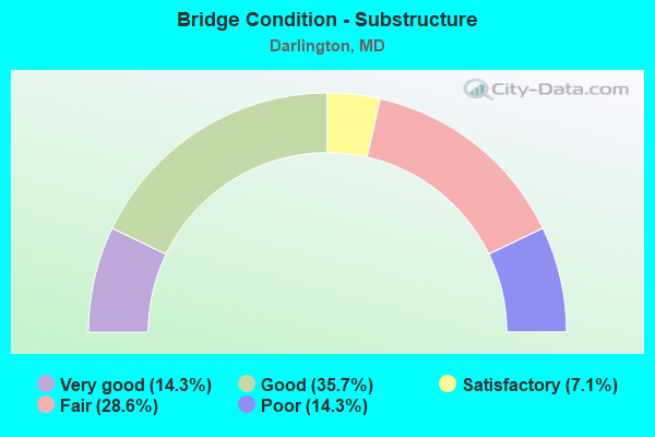
- Bridge Condition - Substructure
- 14.3%Very good
- 35.7%Good
- 7.1%Satisfactory
- 28.6%Fair
- 14.3%Poor
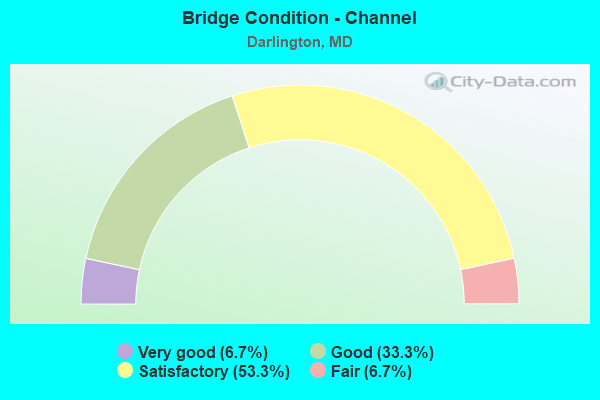
- Bridge Condition - Channel
- 6.7%Very good
- 33.3%Good
- 53.3%Satisfactory
- 6.7%Fair
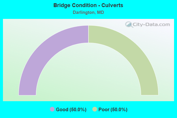
- Bridge Condition - Culverts
- 50.0%Good
- 50.0%Poor
Find on map >> Show street view
Structure Number: 10000007000501, Location: 0.02 MILE NORTH OF MD 222 (Lat: 39.667889, Lng: -76.170025), Route carried "on" structure: US 1, Year Built: 1931, Year Reconstructed: 1984, Status: Open, Structure Length: 1.77m (5.81ft), Average Daily Traffic: 9,652 (year 2009), Truck Traffic: 8%, Average Future Daily Traffic: 14,432 (year 2029), Design Load: HS 20, Features Intersected: NORFOLK SOUTHERN RR
Minimum Vertical Clearance: 30+ m (98+ ft), Kilometerpoint: 0.756, Lanes on structure: 3, Base Highway Network: Yes, Owner: State Highway Agency, Approaching Roadway Width: 14.0m (45.9ft), Skew: 4 degrees, Material/Design: Steel, Design/Construction: Stringer/Multi-beam, Number Of Spans In Main Unit: 1, Length of Maximum Span: 16.2m (53.1ft), Curb-To-Curb Width: 14.0m (45.9ft), Out-to-Out Width: 15.0m (49.2ft)
Condition: Deck: Good, Superstructure: Good, Substructure: Fair, Inventory Rating: 66.2 metric tons, Method Used To Determine Inventory Rating: Load Factor (LF), Structural Evaluation: Somewhat better than minimum adequacy, Deck Geometry: Somewhat better than minimum adequacy, Underclear: High priority of corrective action, Approach Roadway Alignment: Equal to present minimum criteria, Designated Inspection Frequency: Every 24 months, Inspection Date: August 2020, Deck Structure Type: Concrete Cast-file-Place, Wearing Surface/Protective System: Wearing Surface: Monolithic Concrete, Deck Protection: Epoxy Coated Reinforcing
Find on map >> Show street view
Structure Number: 10000007002601, Location: 0.88 MILE SOUTH OF US 1 (Lat: 39.660092, Lng: -76.156692), Route carried "on" structure: State highway 222, Year Built: 1900, Year Reconstructed: 1930, Status: Open, Structure Length: 5.21m (17.09ft), Average Daily Traffic: 2,959 (year 2016), Truck Traffic: 8%, Average Future Daily Traffic: 3,784 (year 2037), Design Load: H 20, Features Intersected: OCTORARO CREEK
Minimum Vertical Clearance: 30+ m (98+ ft), Kilometerpoint: 16.862, Lanes on structure: 2, Owner: State Highway Agency, Approaching Roadway Width: 6.7m (22.0ft), Skew: 2 degrees, Material/Design: Steel, Design/Construction: Stringer/Multi-beam, Number Of Spans In Main Unit: 2, Length of Maximum Span: 24.7m (81.0ft), Curb-To-Curb Width: 7.8m (25.6ft), Out-to-Out Width: 8.9m (29.2ft)
Condition: Deck: Fair, Superstructure: Satisfactory, Substructure: Fair, Channel: Satisfactory, Inventory Rating: 78.5 metric tons, Method Used To Determine Inventory Rating: Load Factor (LF), Structural Evaluation: Somewhat better than minimum adequacy, Deck Geometry: High priority of replacement, Waterway Adequacy: Equal to present desirable criteria, Approach Roadway Alignment: Equal to present desirable criteria, Length Of Structure Improvement: 5.21m (17.09ft), Designated Inspection Frequency: Every 24 months, Underwater Inspection Frequency: Every 48 months, Other Special Inspection Frequency: Every 6 months, Inspection Date: July 2020, Underwater Inspection Date: July 2020, Other Special Inspection Date: July 2021, Bridge Improvement Cost: $301,000, Roadway Improvement Cost: $30,000, Total Project Cost: $331,000, Deck Structure Type: Concrete Cast-file-Place, Wearing Surface/Protective System: Wearing Surface: Monolithic Concrete
Find on map >> Show street view
Structure Number: 10000012004001, Location: 2.11 MILES S OF MD 623 (Lat: 39.616686, Lng: -76.200906), Route carried "on" structure: State highway 161, Year Built: 1995, Status: Open, Structure Length: 8.05m (26.41ft), Average Daily Traffic: 5,291 (year 2009), Truck Traffic: 6%, Average Future Daily Traffic: 6,135 (year 2026), Design Load: HS 25 or greater, Features Intersected: DEER CREEK
Minimum Vertical Clearance: 30+ m (98+ ft), Kilometerpoint: 4.924, Lanes on structure: 2, Owner: State Highway Agency, Approaching Roadway Width: 9.1m (29.9ft), Skew: 3 degrees, Material/Design: Steel continuous, Design/Construction: Stringer/Multi-beam, Number Of Spans In Main Unit: 2, Length of Maximum Span: 39.3m (128.9ft), Curb or Sidewalk Widths: Left: 0.5m (1.6ft), Right: 0.5m (1.6ft), Curb-To-Curb Width: 9.1m (29.9ft), Out-to-Out Width: 10.1m (33.1ft)
Condition: Deck: Good, Superstructure: Good, Substructure: Good, Channel: Good, Operating Rating: 65.3 metric tons, Method Used To Determine Operating Rating: Load Factor (LF), Inventory Rating: 39.0 metric tons, Method Used To Determine Inventory Rating: Load Factor (LF), Structural Evaluation: Better than present minimum criteria, Deck Geometry: Meets minimum limits, Waterway Adequacy: Equal to present desirable criteria, Approach Roadway Alignment: Equal to present minimum criteria, Designated Inspection Frequency: Every 24 months, Inspection Date: July 2020, Deck Structure Type: Concrete Cast-file-Place, Wearing Surface/Protective System: Wearing Surface: Integral Concrete, Deck Protection: Epoxy Coated Reinforcing
Find on map >> Show street view
Structure Number: 10000012005201, Location: 2.63 MI S OF PA LINE (Lat: 39.695689, Lng: -76.244225), Route carried "on" structure: State highway 623, Year Built: 1998, Status: Open, Structure Length: 11.13m (36.52ft), Average Daily Traffic: 1,120 (year 2009), Truck Traffic: 4%, Average Future Daily Traffic: 1,153 (year 2026), Design Load: HS 25 or greater, Features Intersected: BROAD CREEK
Minimum Vertical Clearance: 30+ m (98+ ft), Kilometerpoint: 7.450, Lanes on structure: 2, Owner: State Highway Agency, Approaching Roadway Width: 8.5m (27.9ft), Skew: 2 degrees, Material/Design: Steel continuous, Design/Construction: Stringer/Multi-beam, Number Of Spans In Main Unit: 3, Length of Maximum Span: 45.7m (149.9ft), Curb or Sidewalk Widths: Left: 0.5m (1.6ft), Right: 0.5m (1.6ft), Curb-To-Curb Width: 8.5m (27.9ft), Out-to-Out Width: 9.4m (30.8ft)
Condition: Deck: Good, Superstructure: Good, Substructure: Good, Channel: Good, Inventory Rating: 63.5 metric tons, Method Used To Determine Inventory Rating: Load Factor (LF), Structural Evaluation: Better than present minimum criteria, Deck Geometry: Somewhat better than minimum adequacy, Waterway Adequacy: Equal to present desirable criteria, Approach Roadway Alignment: Equal to present minimum criteria, Designated Inspection Frequency: Every 24 months, Underwater Inspection Frequency: Every 48 months, Inspection Date: June 2020, Underwater Inspection Date: July 2018, Deck Structure Type: Concrete Cast-file-Place, Wearing Surface/Protective System: Wearing Surface: Monolithic Concrete, Deck Protection: Epoxy Coated Reinforcing
Find on map >> Show street view
Structure Number: 10000012005302, Location: 2.03 MILES N OF US 1 (Lat: 39.675644, Lng: -76.215397), Route carried "on" structure: State highway 623, Year Built: 1987, Status: Open, Structure Length: 0.75m (2.46ft), Average Daily Traffic: 1,501 (year 2013), Truck Traffic: 8%, Average Future Daily Traffic: 1,153 (year 2026), Design Load: HS 20, Features Intersected: PEDDLER RUN
Minimum Vertical Clearance: 30+ m (98+ ft), Kilometerpoint: 3.572, Lanes on structure: 2, Owner: State Highway Agency, Approaching Roadway Width: 9.4m (30.8ft), Skew: 3 degrees, Material/Design: Concrete, Design/Construction: Culvert, Length of Maximum Span: 2.1m (6.9ft)
Condition: Channel: Satisfactory, Culverts: Good, Operating Rating: 32.7 metric tons, Method Used To Determine Operating Rating: Field evaluation and documented engineering judgment, Inventory Rating: 32.7 metric tons, Method Used To Determine Inventory Rating: Field evaluation and documented engineering judgment, Structural Evaluation: Better than present minimum criteria, Waterway Adequacy: Better than present minimum criteria, Approach Roadway Alignment: Equal to present desirable criteria, Designated Inspection Frequency: Every 24 months, Inspection Date: March 2020
Find on map >> Show street view
Structure Number: 10000012009003, Location: 0.47 MILE NORTH OF MD 161 (Lat: 39.652283, Lng: -76.203686), Route carried "on" structure: State highway 623, Year Built: 1993, Status: Open, Structure Length: 0.79m (2.59ft), Average Daily Traffic: 1,620 (year 2009), Truck Traffic: 8%, Average Future Daily Traffic: 1,741 (year 2026), Features Intersected: BR OF SUSQUEHANNA RIV
Minimum Vertical Clearance: 30+ m (98+ ft), Kilometerpoint: 0.756, Lanes on structure: 2, Owner: State Highway Agency, Approaching Roadway Width: 7.9m (25.9ft), Skew: 3 degrees, Material/Design: Steel, Design/Construction: Culvert, Number Of Spans In Main Unit: 1, Length of Maximum Span: 7.9m (25.9ft)
Condition: Channel: Good, Culverts: Poor, Operating Rating: 32.7 metric tons, Method Used To Determine Operating Rating: Field evaluation and documented engineering judgment, Inventory Rating: 32.7 metric tons, Method Used To Determine Inventory Rating: Field evaluation and documented engineering judgment, Structural Evaluation: Meets minimum limits, Waterway Adequacy: Better than present minimum criteria, Approach Roadway Alignment: Equal to present desirable criteria, Designated Inspection Frequency: Every 12 months, Inspection Date: January 2022, Wearing Surface/Protective System: Wearing Surface: Bituminous
Find on map >> Show street view
Structure Number: 200000CE000101, Location: 0.61 MI E OF OAKWOOD RD (Lat: 39.700539, Lng: -76.189103), Route carried "on" structure: County highway 4, Year Built: 1972, Status: Open, Structure Length: 1.52m (4.99ft), Average Daily Traffic: 750 (year 2015), Truck Traffic: 5%, Average Future Daily Traffic: 1,230 (year 2037), Features Intersected: CONOWINGO CREEK, Facility Carried by Structure: PILOT TOWN ROAD
Minimum Vertical Clearance: 30+ m (98+ ft), Kilometerpoint: 1.689, Lanes on structure: 2, Owner: County Highway Agency, Approaching Roadway Width: 6.4m (21.0ft), Skew: 3 degrees, Material/Design: Steel, Design/Construction: Stringer/Multi-beam, Number Of Spans In Main Unit: 1, Length of Maximum Span: 14.9m (48.9ft), Curb-To-Curb Width: 6.9m (22.6ft), Out-to-Out Width: 7.7m (25.3ft)
Condition: Deck: Good, Superstructure: Fair, Substructure: Fair, Channel: Fair, Operating Rating: 67.1 metric tons, Method Used To Determine Operating Rating: Load Factor (LF), Inventory Rating: 40.4 metric tons, Method Used To Determine Inventory Rating: Load Factor (LF), Structural Evaluation: Somewhat better than minimum adequacy, Deck Geometry: Meets minimum limits, Waterway Adequacy: Meets minimum limits, Approach Roadway Alignment: Equal to present minimum criteria, Length Of Structure Improvement: 1.52m (4.99ft), Designated Inspection Frequency: Every 24 months, Inspection Date: June 2021, Bridge Improvement Cost: $46,000, Roadway Improvement Cost: $10,000, Total Project Cost: $57,000, Deck Structure Type: Concrete Cast-file-Place, Wearing Surface/Protective System: Wearing Surface: Bituminous
Find on map >> Show street view
Structure Number: 200000CE000201, Location: 0.03 MI N OF OLD CON RD (Lat: 39.684628, Lng: -76.194933), Route carried "on" structure: County highway 3, Year Built: 1885, Year Reconstructed: 1989, Status: Posted for load, Structure Length: 3.28m (10.76ft), Average Daily Traffic: 120 (year 2017), Truck Traffic: 5%, Average Future Daily Traffic: 140 (year 2039), Features Intersected: CONOWINGO CREEK, Facility Carried by Structure: BELL MANOR RD
Minimum Vertical Clearance: 30+ m (98+ ft), Kilometerpoint: 4.859, Lanes on structure: 1, Owner: County Highway Agency, Approaching Roadway Width: 4.9m (16.1ft), Material/Design: Steel, Design/Construction: Truss - Thru, Number Of Spans In Main Unit: 1, Length of Maximum Span: 32.0m (105.0ft), Curb-To-Curb Width: 4.8m (15.7ft), Out-to-Out Width: 5.9m (19.4ft)
Condition: Deck: Good, Superstructure: Satisfactory, Substructure: Fair, Channel: Satisfactory, Operating Rating: 20.0 metric tons, Method Used To Determine Operating Rating: Allowable Stress (AS), Inventory Rating: 9.1 metric tons, Method Used To Determine Inventory Rating: Allowable Stress (AS), Structural Evaluation: High priority of corrective action, Deck Geometry: High priority of corrective action, Waterway Adequacy: Equal to present minimum criteria, Approach Roadway Alignment: Meets minimum limits, Bridge Posting: Required (Relationship of Operating Rating to Maximum Legal Load: 30.0 - 39.9% below), Length Of Structure Improvement: 3.29m (10.79ft), Designated Inspection Frequency: Every 24 months, Critical Feature Inspection Frequency: Every 24 months, Underwater Inspection Frequency: Every 60 months, Inspection Date: January 2021, Critical Feature Inspection Date: January 2021, Underwater Inspection Date: January 2021, Bridge Improvement Cost: $62,000, Roadway Improvement Cost: $7,000, Total Project Cost: $69,000, Deck Structure Type: Open Grating
Find on map >> Show street view
Structure Number: 200000H-002601, Location: 0.3 MI S OF HARMONY CH RD (Lat: 39.606356, Lng: -76.218258), Route carried "on" structure: County highway 218, Year Built: 1930, Year Reconstructed: 1952, Status: Open, Structure Length: 0.82m (2.69ft), Average Daily Traffic: 349 (year 2021), Truck Traffic: 5%, Average Future Daily Traffic: 428 (year 2041), Features Intersected: GRAVEYARD CREEK, Facility Carried by Structure: GLENVILLE ROAD
Minimum Vertical Clearance: 30+ m (98+ ft), Kilometerpoint: 8.866, Lanes on structure: 2, Owner: County Highway Agency, Approaching Roadway Width: 4.9m (16.1ft), Skew: 4 degrees, Material/Design: Steel, Design/Construction: Stringer/Multi-beam, Number Of Spans In Main Unit: 1, Length of Maximum Span: 7.0m (23.0ft), Curb-To-Curb Width: 5.3m (17.4ft), Out-to-Out Width: 5.6m (18.4ft)
Condition: Deck: Satisfactory, Superstructure: Fair, Substructure: Good, Channel: Good, Inventory Rating: 58.5 metric tons, Method Used To Determine Inventory Rating: Load Factor (LF), Structural Evaluation: Somewhat better than minimum adequacy, Deck Geometry: High priority of replacement, Waterway Adequacy: Equal to present minimum criteria, Approach Roadway Alignment: Equal to present minimum criteria, Designated Inspection Frequency: Every 24 months, Inspection Date: August 2021, Deck Structure Type: Concrete Cast-file-Place, Wearing Surface/Protective System: Wearing Surface: Bituminous
Find on map >> Show street view
Structure Number: 200000H-002801, Location: 1.4 MILES E OF MD 136 (Lat: 39.604825, Lng: -76.240150), Route carried "on" structure: County highway 193, Year Built: 1933, Year Reconstructed: 2004, Status: Open, Structure Length: 0.82m (2.69ft), Average Daily Traffic: 133 (year 2021), Truck Traffic: 5%, Average Future Daily Traffic: 164 (year 2041), Design Load: HS 20, Features Intersected: MILL BROOK, Facility Carried by Structure: HARMONY CHURCH RD
Minimum Vertical Clearance: 30+ m (98+ ft), Kilometerpoint: 4.039, Lanes on structure: 1, Owner: County Highway Agency, Approaching Roadway Width: 5.2m (17.1ft), Skew: 2 degrees, Material/Design: Steel, Design/Construction: Stringer/Multi-beam, Number Of Spans In Main Unit: 1, Length of Maximum Span: 7.9m (25.9ft), Curb-To-Curb Width: 4.2m (13.8ft), Out-to-Out Width: 4.8m (15.7ft)
Condition: Deck: Good, Superstructure: Good, Substructure: Good, Channel: Good, Operating Rating: 87.5 metric tons, Method Used To Determine Operating Rating: Load Factor (LF), Inventory Rating: 52.6 metric tons, Method Used To Determine Inventory Rating: Load Factor (LF), Structural Evaluation: Better than present minimum criteria, Deck Geometry: High priority of replacement, Waterway Adequacy: Better than present minimum criteria, Approach Roadway Alignment: High priority of corrective action, Designated Inspection Frequency: Every 24 months, Inspection Date: August 2021, Deck Structure Type: Wood or Timber, Wearing Surface/Protective System: Wearing Surface: Wood or Timber, Deck Protection: Other
Find on map >> Show street view
Structure Number: 200000H-003001, Location: 2.1 MILES NE OF MD 22 (Lat: 39.586367, Lng: -76.231128), Route carried "on" structure: County highway 218, Year Built: 1930, Year Reconstructed: 1935, Status: Open, Structure Length: 1.16m (3.81ft), Average Daily Traffic: 816 (year 2020), Truck Traffic: 5%, Average Future Daily Traffic: 520 (year 2040), Features Intersected: MILL BROOK, Facility Carried by Structure: GLENVILLE ROAD
Minimum Vertical Clearance: 30+ m (98+ ft), Kilometerpoint: 8.866, Lanes on structure: 2, Owner: County Highway Agency, Approaching Roadway Width: 5.2m (17.1ft), Material/Design: Steel, Design/Construction: Stringer/Multi-beam, Number Of Spans In Main Unit: 1, Length of Maximum Span: 10.7m (35.1ft), Curb-To-Curb Width: 5.1m (16.7ft), Out-to-Out Width: 5.4m (17.7ft)
Condition: Deck: Poor, Superstructure: Fair, Substructure: Poor, Channel: Satisfactory, Operating Rating: 66.7 metric tons, Method Used To Determine Operating Rating: Load Factor (LF), Inventory Rating: 39.9 metric tons, Method Used To Determine Inventory Rating: Load Factor (LF), Structural Evaluation: Meets minimum limits, Deck Geometry: High priority of replacement, Waterway Adequacy: Better than present minimum criteria, Approach Roadway Alignment: Equal to present minimum criteria, Designated Inspection Frequency: Every 24 months, Other Special Inspection Frequency: Every 12 months, Inspection Date: August 2021, Other Special Inspection Date: August 2021, Deck Structure Type: Concrete Cast-file-Place, Wearing Surface/Protective System: Wearing Surface: Bituminous
Find on map >> Show street view
Structure Number: 200000H-015501, Location: GLEN COVE RD 0.71 (Lat: 39.661050, Lng: -76.244394), Route carried "on" structure: County highway 154, Year Built: 1930, Year Reconstructed: 1955, Status: Temporarily open, Structure Length: 0.64m (2.10ft), Average Daily Traffic: 890 (year 2019), Truck Traffic: 5%, Average Future Daily Traffic: 1,090 (year 2039), Features Intersected: PEDDLER RUN, Facility Carried by Structure: GLEN COVE ROAD
Minimum Vertical Clearance: 30+ m (98+ ft), Kilometerpoint: 1.142, Lanes on structure: 1, Owner: County Highway Agency, Approaching Roadway Width: 5.5m (18.0ft), Material/Design: Steel, Design/Construction: Truss - Thru, Number Of Spans In Main Unit: 1, Length of Maximum Span: 5.2m (17.1ft), Curb-To-Curb Width: 3.2m (10.5ft), Out-to-Out Width: 4.2m (13.8ft)
Condition: Deck: Satisfactory, Superstructure: Good, Substructure: Very good, Channel: Satisfactory, Structural Evaluation: High priority of replacement, Deck Geometry: High priority of replacement, Waterway Adequacy: Equal to present minimum criteria, Approach Roadway Alignment: Equal to present minimum criteria, Length Of Structure Improvement: 1.22m (4.00ft), Designated Inspection Frequency: Every 24 months, Critical Feature Inspection Frequency: Every 24 months, Inspection Date: July 2021, Critical Feature Inspection Date: July 2021, Bridge Improvement Cost: $500,000, Roadway Improvement Cost: $100,000, Total Project Cost: $600,000 ( Estimate for 2019), Deck Structure Type: Steel plate, Wearing Surface/Protective System: Wearing Surface: Other
Find on map >> Show street view
Structure Number: 200000H-015601, Location: 1.90 MI. E OF DUBLIN (Lat: 39.664711, Lng: -76.236281), Route carried "on" structure: County highway 154, Year Built: 2019, Status: Open, Structure Length: 0.92m (3.02ft), Average Daily Traffic: 481 (year 2019), Truck Traffic: 2%, Average Future Daily Traffic: 588 (year 2039), Features Intersected: PEDDLER RUN, Facility Carried by Structure: GLEN COVE ROAD
Minimum Vertical Clearance: 30+ m (98+ ft), Kilometerpoint: 5.261, Lanes on structure: 2, Owner: County Highway Agency, Approaching Roadway Width: 7.3m (24.0ft), Skew: 1 degrees, Material/Design: Prestressed concrete, Design/Construction: Box Beam or Girders - Multiple, Number Of Spans In Main Unit: 1, Length of Maximum Span: 7.6m (24.9ft), Curb-To-Curb Width: 7.5m (24.6ft), Out-to-Out Width: 8.1m (26.6ft)
Condition: Deck: Very good, Superstructure: Very good, Substructure: Very good, Channel: Very good, Operating Rating: 60.3 metric tons, Method Used To Determine Operating Rating: Load and Resistance Factor Rating (LRFR) rating reported by rating factor(RF) method using HL-93 loadings, Inventory Rating: 46.3 metric tons, Method Used To Determine Inventory Rating: Load and Resistance Factor Rating (LRFR) rating reported by rating factor(RF) method using HL-93 loadings, Structural Evaluation: Equal to present desirable criteria, Deck Geometry: Meets minimum limits, Waterway Adequacy: Equal to present desirable criteria, Approach Roadway Alignment: Equal to present desirable criteria, Designated Inspection Frequency: Every 24 months, Inspection Date: July 2021, Deck Structure Type: Concrete Cast-file-Place, Wearing Surface/Protective System: Wearing Surface: Integral Concrete
Find on map >> Show street view
Structure Number: 200000H-016001, Location: 0.8 MI E MAIN ST (Lat: 39.617694, Lng: -76.237481), Route carried "on" structure: County highway 171, Year Built: 1883, Year Reconstructed: 1998, Status: Posted for load, Structure Length: 4.63m (15.19ft), Average Daily Traffic: 70 (year 2019), Truck Traffic: 5%, Average Future Daily Traffic: 90 (year 2039), Design Load: H 15, Features Intersected: DEER CREEK, Facility Carried by Structure: NOBLES MILL ROAD
Minimum Vertical Clearance: 4.88m (16.01ft), Kilometerpoint: 2.719, Lanes on structure: 1, Owner: County Highway Agency, Approaching Roadway Width: 4.6m (15.1ft), Material/Design: Steel, Design/Construction: Truss - Thru, Number Of Spans In Main Unit: 1, Length of Maximum Span: 45.1m (148.0ft), Curb-To-Curb Width: 4.0m (13.1ft), Out-to-Out Width: 4.3m (14.1ft)
Condition: Deck: Satisfactory, Superstructure: Poor, Substructure: Good, Channel: Satisfactory, Operating Rating: 26.8 metric tons, Method Used To Determine Operating Rating: Allowable Stress (AS), Inventory Rating: 16.3 metric tons, Method Used To Determine Inventory Rating: Allowable Stress (AS), Structural Evaluation: Meets minimum limits, Deck Geometry: Somewhat better than minimum adequacy, Waterway Adequacy: Equal to present minimum criteria, Approach Roadway Alignment: High priority of corrective action, Bridge Posting: Required (Relationship of Operating Rating to Maximum Legal Load: 20.0 - 29.9% below), Length Of Structure Improvement: 4.57m (14.99ft), Designated Inspection Frequency: Every 24 months, Critical Feature Inspection Frequency: Every 24 months, Other Special Inspection Frequency: Every 12 months, Inspection Date: November 2021, Critical Feature Inspection Date: November 2021, Other Special Inspection Date: November 2021, Bridge Improvement Cost: $2,250,000, Roadway Improvement Cost: $225,000, Total Project Cost: $2,475,000, Deck Structure Type: Wood or Timber, Wearing Surface/Protective System: Wearing Surface: Wood or Timber, Deck Protection: Other
Find on map >> Show street view
Structure Number: 200000H-016101, Location: 1.1 MILES SW OF MD 161 (Lat: 39.630533, Lng: -76.223614), Route carried "on" structure: County highway 167, Year Built: 1952, Status: Posted for load, Structure Length: 0.98m (3.22ft), Average Daily Traffic: 591 (year 2020), Truck Traffic: 5%, Average Future Daily Traffic: 714 (year 2040), Features Intersected: HOLLANDS BRANCH, Facility Carried by Structure: TRAPPE CHURCH ROAD
Minimum Vertical Clearance: 30+ m (98+ ft), Kilometerpoint: 5.278, Lanes on structure: 2, Owner: County Highway Agency, Approaching Roadway Width: 5.5m (18.0ft), Material/Design: Steel, Design/Construction: Stringer/Multi-beam, Number Of Spans In Main Unit: 1, Length of Maximum Span: 8.8m (28.9ft), Curb-To-Curb Width: 7.2m (23.6ft), Out-to-Out Width: 7.5m (24.6ft)
Condition: Deck: Poor, Superstructure: Poor, Substructure: Poor, Channel: Satisfactory, Operating Rating: 44.9 metric tons, Method Used To Determine Operating Rating: Load Factor (LF), Inventory Rating: 26.8 metric tons, Method Used To Determine Inventory Rating: Load Factor (LF), Structural Evaluation: Meets minimum limits, Deck Geometry: Meets minimum limits, Waterway Adequacy: Equal to present minimum criteria, Approach Roadway Alignment: Better than present minimum criteria, Bridge Posting: Required (Relationship of Operating Rating to Maximum Legal Load: 30.0 - 39.9% below), Designated Inspection Frequency: Every 24 months, Other Special Inspection Frequency: Every 12 months, Inspection Date: July 2021, Other Special Inspection Date: July 2021, Deck Structure Type: Concrete Cast-file-Place, Wearing Surface/Protective System: Wearing Surface: Bituminous
Find on map >> Show street view
Structure Number: 200000H-016201, Location: 0.5 MIL W OF GRAIGS CR RD (Lat: 39.626614, Lng: -76.169681), Route carried "on" structure: County highway 169, Year Built: 1980, Status: Posted for load, Structure Length: 1.01m (3.31ft), Average Daily Traffic: 508 (year 2019), Truck Traffic: 5%, Average Future Daily Traffic: 620 (year 2039), Features Intersected: BUCK BRANCH, Facility Carried by Structure: STAFFORD ROAD
Minimum Vertical Clearance: 30+ m (98+ ft), Kilometerpoint: 2.977, Lanes on structure: 2, Owner: County Highway Agency, Approaching Roadway Width: 7.3m (24.0ft), Skew: 3 degrees, Material/Design: Steel, Design/Construction: Stringer/Multi-beam, Number Of Spans In Main Unit: 1, Length of Maximum Span: 8.8m (28.9ft), Curb or Sidewalk Widths: Left: 0.4m (1.3ft), Right: 0.4m (1.3ft), Curb-To-Curb Width: 7.7m (25.3ft), Out-to-Out Width: 8.5m (27.9ft)
Condition: Deck: Poor, Superstructure: Fair, Substructure: Satisfactory, Channel: Satisfactory, Operating Rating: 64.9 metric tons, Method Used To Determine Operating Rating: Load Factor (LF), Inventory Rating: 39.0 metric tons, Method Used To Determine Inventory Rating: Load Factor (LF), Structural Evaluation: Somewhat better than minimum adequacy, Deck Geometry: Meets minimum limits, Waterway Adequacy: Equal to present minimum criteria, Approach Roadway Alignment: Equal to present desirable criteria, Designated Inspection Frequency: Every 24 months, Inspection Date: August 2021, Deck Structure Type: Concrete Cast-file-Place, Wearing Surface/Protective System: Wearing Surface: Monolithic Concrete