Bridge Statistics for Danvers, Massachusetts (MA)
Condition, Traffic, Stress, Structural Evaluation, Project Costs
- National Bridge Inventory (NBI) Statistics
- 22Number of bridges
- 256ft / 78.1mTotal length
- $75,921,000Total costs
- 930,459Total average daily traffic
- 70,762Total average daily truck traffic
- 1,352,510Total future (year 2032) average daily traffic
- National Bridge Inventory (NBI) Registered Bridges for Danvers
- No street view available for this location
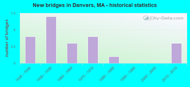
- New bridges - historical statistics
- 41940-1949
- 71950-1959
- 31960-1969
- 41970-1979
- 11980-1989
- 32010-2019
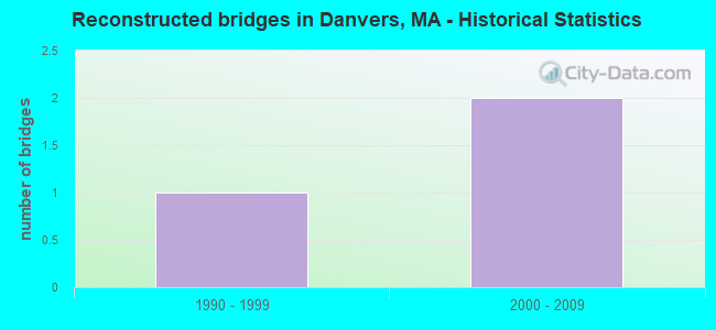
- Reconstructed bridges - Historical Statistics
- 11990-1999
- 22000-2009
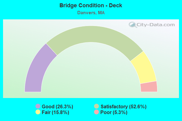
- Bridge Condition - Deck
- 26.3%Good
- 52.6%Satisfactory
- 15.8%Fair
- 5.3%Poor
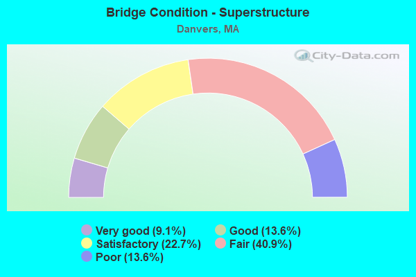
- Bridge Condition - Superstructure
- 9.1%Very good
- 13.6%Good
- 22.7%Satisfactory
- 40.9%Fair
- 13.6%Poor
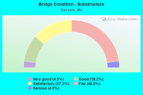
- Bridge Condition - Substructure
- 4.5%Very good
- 18.2%Good
- 27.3%Satisfactory
- 45.5%Fair
- 4.5%Serious
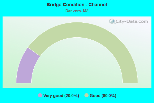
- Bridge Condition - Channel
- 20.0%Very good
- 80.0%Good
Find on map >> Show street view
Structure Number: D030022PEMUNNBI, Location: .75 MI NW OF PEABODY (Lat: 42.552258, Lng: -70.924983), Route carried "on" structure: City street 35, Year Built: 1980, Status: Open, Structure Length: 1.71m (5.61ft), Average Daily Traffic: 32,000 (year 2019), Truck Traffic: 7%, Average Future Daily Traffic: 42,325 (year 2032), Design Load: HS 20, Features Intersected: WATER CRANE RIVER
Minimum Vertical Clearance: 30+ m (98+ ft), Kilometerpoint: 1.070, Lanes on structure: 2, Owner: Town or Township Highway Agency, Approaching Roadway Width: 10.4m (34.1ft), Skew: 1 degrees, Material/Design: Prestressed concrete, Design/Construction: Stringer/Multi-beam, Number Of Spans In Main Unit: 1, Length of Maximum Span: 16.8m (55.1ft), Curb or Sidewalk Widths: Left: 1.5m (4.9ft), Right: 1.5m (4.9ft), Curb-To-Curb Width: 10.4m (34.1ft), Out-to-Out Width: 14.3m (46.9ft)
Condition: Deck: Satisfactory, Superstructure: Fair, Substructure: Satisfactory, Channel: Good, Operating Rating: 51.4 metric tons, Method Used To Determine Operating Rating: Load Factor (LF), Inventory Rating: 32.0 metric tons, Method Used To Determine Inventory Rating: Load Factor (LF), Structural Evaluation: Somewhat better than minimum adequacy, Deck Geometry: Meets minimum limits, Waterway Adequacy: Superior to present desirable criteria, Approach Roadway Alignment: Meets minimum limits, Length Of Structure Improvement: 1.80m (5.91ft), Designated Inspection Frequency: Every 24 months, Inspection Date: June 2021, Bridge Improvement Cost: $1,012,000, Roadway Improvement Cost: $102,000, Total Project Cost: $1,519,000 ( Estimate for 2022), Deck Structure Type: Concrete Cast-file-Place, Wearing Surface/Protective System: Wearing Surface: Bituminous, Membrane: Built-up, Deck Protection: Epoxy Coated Reinforcing
Find on map >> Show street view
Structure Number: D03003325DOT634, Location: .5 MI E ST 128 (Lat: 42.550131, Lng: -70.926792), Route carried "on" structure: State highway , Year Built: 1952, Status: Open, Structure Length: 0.91m (2.99ft), Average Daily Traffic: 28,800 (year 2019), Truck Traffic: 9%, Average Future Daily Traffic: 15,477 (year 2032), Design Load: H 20, Features Intersected: RR MBTA/BMRR, Facility Carried by Structure: HWY ENDICOTT ST
Minimum Vertical Clearance: 30+ m (98+ ft), Kilometerpoint: 0.483, Lanes on structure: 4, Owner: State Highway Agency, Approaching Roadway Width: 12.2m (40.0ft), Skew: 1 degrees, Material/Design: Prestressed concrete, Design/Construction: Stringer/Multi-beam, Number Of Spans In Main Unit: 1, Length of Maximum Span: 7.0m (23.0ft), Curb or Sidewalk Widths: Left: 1.8m (5.9ft), Right: 1.8m (5.9ft), Curb-To-Curb Width: 12.2m (40.0ft), Out-to-Out Width: 16.5m (54.1ft)
Condition: Deck: Satisfactory, Superstructure: Satisfactory, Substructure: Satisfactory, Operating Rating: 70.9 metric tons, Method Used To Determine Operating Rating: Load Factor (LF), Inventory Rating: 42.5 metric tons, Method Used To Determine Inventory Rating: Load Factor (LF), Structural Evaluation: Equal to present minimum criteria, Deck Geometry: High priority of replacement, Underclear: High priority of corrective action, Approach Roadway Alignment: Equal to present minimum criteria, Length Of Structure Improvement: 1.00m (3.28ft), Designated Inspection Frequency: Every 24 months, Inspection Date: June 2021, Bridge Improvement Cost: $934,000, Roadway Improvement Cost: $94,000, Total Project Cost: $1,402,000 ( Estimate for 2022), Deck Structure Type: Concrete Cast-file-Place, Wearing Surface/Protective System: Wearing Surface: Bituminous, Membrane: Built-up
Find on map >> Show street view
Structure Number: D030092UHDOTNBI, Location: OVER IPSWICH RIVER (Lat: 42.573953, Lng: -70.993483), Route carried "on" structure: State highway 114, Year Built: 1954, Status: Open, Structure Length: 1.33m (4.36ft), Average Daily Traffic: 38,957 (year 2020), Truck Traffic: 5%, Average Future Daily Traffic: 81,650 (year 2032), Design Load: HS 20, Features Intersected: WATER IPSWICH RIVER
Minimum Vertical Clearance: 30+ m (98+ ft), Kilometerpoint: 20.422, Lanes on structure: 2, Base Highway Network: Yes, Owner: State Highway Agency, Approaching Roadway Width: 12.2m (40.0ft), Material/Design: Steel, Design/Construction: Stringer/Multi-beam, Number Of Spans In Main Unit: 1, Length of Maximum Span: 12.8m (42.0ft), Curb or Sidewalk Widths: Left: 0.8m (2.6ft), Right: 0.8m (2.6ft), Curb-To-Curb Width: 12.2m (40.0ft), Out-to-Out Width: 14.9m (48.9ft)
Condition: Deck: Poor, Superstructure: Satisfactory, Substructure: Serious, Channel: Good, Operating Rating: 48.9 metric tons, Method Used To Determine Operating Rating: Load Factor (LF), Inventory Rating: 29.3 metric tons, Method Used To Determine Inventory Rating: Load Factor (LF), Structural Evaluation: High priority of corrective action, Deck Geometry: Somewhat better than minimum adequacy, Waterway Adequacy: Equal to present desirable criteria, Approach Roadway Alignment: Equal to present minimum criteria, Length Of Structure Improvement: 2.10m (6.89ft), Designated Inspection Frequency: Every 6 months, Underwater Inspection Frequency: Every 12 months, Other Special Inspection Frequency: Every 6 months, Inspection Date: September 2021, Underwater Inspection Date: June 2021, Other Special Inspection Date: September 2021, Bridge Improvement Cost: $1,771,000, Roadway Improvement Cost: $178,000, Total Project Cost: $2,657,000 ( Estimate for 2022), Deck Structure Type: Concrete Cast-file-Place, Wearing Surface/Protective System: Wearing Surface: Latex Concrete
Find on map >> Show street view
Structure Number: D03013AVFMUNNBI, Location: .25 MI NW OF PEABODY (Lat: 42.545836, Lng: -70.920583), Route carried "on" structure: City street 35, Year Built: 2016, Status: Open, Structure Length: 4.37m (14.34ft), Average Daily Traffic: 27,500 (year 2017), Truck Traffic: 2%, Design Load: HL 93, Features Intersected: WATER WATERS RIVER
Minimum Vertical Clearance: 30+ m (98+ ft), Kilometerpoint: 1.893, Lanes on structure: 2, Owner: Town or Township Highway Agency, Approaching Roadway Width: 14.7m (48.2ft), Material/Design: Prestressed concrete continuous, Design/Construction: Box Beam or Girders - Multiple, Number Of Spans In Main Unit: 2, Length of Maximum Span: 20.6m (67.6ft), Curb or Sidewalk Widths: Left: 3.0m (9.8ft), Right: 5.2m (17.1ft), Curb-To-Curb Width: 14.7m (48.2ft), Out-to-Out Width: 23.7m (77.8ft)
Condition: Deck: Good, Superstructure: Good, Substructure: Good, Channel: Very good, Operating Rating: 42.1 metric tons, Method Used To Determine Operating Rating: Assigned ratings based on Load and Resistance Factor Design (LRFD) reported by rating factor (RF) using HL93 loadings, Inventory Rating: 32.4 metric tons, Method Used To Determine Inventory Rating: Assigned ratings based on Load and Resistance Factor Design (LRFD) reported by rating factor (RF) using HL93 loadings, Structural Evaluation: Better than present minimum criteria, Deck Geometry: Superior to present desirable criteria, Waterway Adequacy: Superior to present desirable criteria, Approach Roadway Alignment: Equal to present desirable criteria, Designated Inspection Frequency: Every 24 months, Inspection Date: September 2021, Deck Structure Type: Concrete Cast-file-Place, Wearing Surface/Protective System: Wearing Surface: Bituminous, Membrane: Built-up, Deck Protection: Epoxy Coated Reinforcing
Find on map >> Show street view
Structure Number: D030162T6DOTNBI, Location: 1.6 MI N ST114 (Lat: 42.583950, Lng: -70.967172), Route carried "on" structure: US 1, Year Built: 1950, Year Reconstructed: 2009, Status: Open, Structure Length: 2.99m (9.81ft), Average Daily Traffic: 23,230 (year 2019), Truck Traffic: 3%, Average Future Daily Traffic: 46,905 (year 2031), Design Load: HS 25 or greater, Features Intersected: ST 62 MAPLE ST
Minimum Vertical Clearance: 30+ m (98+ ft), Kilometerpoint: 92.647, Lanes on structure: 2, Lanes under structure: 4, Base Highway Network: Yes, Owner: State Highway Agency, Approaching Roadway Width: 9.8m (32.2ft), Skew: 2 degrees, Material/Design: Steel continuous, Design/Construction: Stringer/Multi-beam, Number Of Spans In Main Unit: 2, Length of Maximum Span: 13.7m (44.9ft), Curb or Sidewalk Widths: Left: 0.0m, Right: 2.4m (7.9ft), Curb-To-Curb Width: 11.3m (37.1ft), Out-to-Out Width: 15.4m (50.5ft)
Condition: Deck: Good, Superstructure: Good, Substructure: Good, Inventory Rating: 67.2 metric tons, Method Used To Determine Inventory Rating: Load Factor (LF), Structural Evaluation: Better than present minimum criteria, Deck Geometry: Equal to present minimum criteria, Underclear: Somewhat better than minimum adequacy, Approach Roadway Alignment: Equal to present minimum criteria, Length Of Structure Improvement: 3.00m (9.84ft), Designated Inspection Frequency: Every 24 months, Inspection Date: May 2020, Bridge Improvement Cost: $425,000, Roadway Improvement Cost: $43,000, Total Project Cost: $638,000 ( Estimate for 2022), Deck Structure Type: Concrete Cast-file-Place, Wearing Surface/Protective System: Wearing Surface: Bituminous, Membrane: Preformed Fabric, Deck Protection: Epoxy Coated Reinforcing
Find on map >> Show street view
Structure Number: D030162T7DOTNBI, Location: 1.6 MI N ST114 (Lat: 42.584069, Lng: -70.967386), Route carried "on" structure: US 1, Year Built: 1950, Year Reconstructed: 2009, Status: Open, Structure Length: 2.99m (9.81ft), Average Daily Traffic: 19,815 (year 2019), Truck Traffic: 3%, Average Future Daily Traffic: 46,905 (year 2031), Design Load: H 20, Features Intersected: ST 62 MAPLE ST
Minimum Vertical Clearance: 30+ m (98+ ft), Kilometerpoint: 92.647, Lanes on structure: 2, Lanes under structure: 4, Base Highway Network: Yes, Owner: State Highway Agency, Approaching Roadway Width: 11.3m (37.1ft), Skew: 2 degrees, Material/Design: Steel continuous, Design/Construction: Stringer/Multi-beam, Number Of Spans In Main Unit: 2, Length of Maximum Span: 13.7m (44.9ft), Curb or Sidewalk Widths: Left: 0.0m, Right: 2.4m (7.9ft), Curb-To-Curb Width: 11.3m (37.1ft), Out-to-Out Width: 15.4m (50.5ft)
Condition: Deck: Good, Superstructure: Good, Substructure: Good, Inventory Rating: 67.2 metric tons, Method Used To Determine Inventory Rating: Load Factor (LF), Structural Evaluation: Better than present minimum criteria, Deck Geometry: Equal to present minimum criteria, Underclear: Somewhat better than minimum adequacy, Approach Roadway Alignment: Better than present minimum criteria, Length Of Structure Improvement: 3.00m (9.84ft), Designated Inspection Frequency: Every 24 months, Inspection Date: May 2020, Bridge Improvement Cost: $425,000, Roadway Improvement Cost: $43,000, Total Project Cost: $638,000 ( Estimate for 2022), Deck Structure Type: Concrete Cast-file-Place, Wearing Surface/Protective System: Wearing Surface: Bituminous, Membrane: Preformed Fabric, Deck Protection: Epoxy Coated Reinforcing
Find on map >> Show street view
Structure Number: D030172T2DOTNBI, Location: 1.6 MI S ST62 (Lat: 42.560767, Lng: -70.977381), Route carried "on" structure: US 1, Year Built: 1950, Status: Open, Structure Length: 2.44m (8.01ft), Average Daily Traffic: 24,220 (year 2017), Truck Traffic: 10%, Average Future Daily Traffic: 75,017 (year 2031), Design Load: HS 20, Features Intersected: ST114 ANDOVER ST
Minimum Vertical Clearance: 30+ m (98+ ft), Kilometerpoint: 89.928, Lanes on structure: 2, Lanes under structure: 4, Base Highway Network: Yes, Owner: State Highway Agency, Approaching Roadway Width: 11.0m (36.1ft), Material/Design: Steel continuous, Design/Construction: Stringer/Multi-beam, Number Of Spans In Main Unit: 2, Length of Maximum Span: 11.6m (38.1ft), Curb or Sidewalk Widths: Left: 0.0m, Right: 2.1m (6.9ft), Curb-To-Curb Width: 10.6m (34.8ft), Out-to-Out Width: 14.8m (48.6ft)
Condition: Deck: Satisfactory, Superstructure: Fair, Substructure: Fair, Inventory Rating: 26.6 metric tons, Method Used To Determine Inventory Rating: Allowable Stress (AS), Structural Evaluation: Somewhat better than minimum adequacy, Deck Geometry: Somewhat better than minimum adequacy, Underclear: Meets minimum limits, Approach Roadway Alignment: Equal to present desirable criteria, Length Of Structure Improvement: 2.50m (8.20ft), Designated Inspection Frequency: Every 24 months, Inspection Date: August 2020, Bridge Improvement Cost: $1,454,000, Roadway Improvement Cost: $146,000, Total Project Cost: $2,182,000 ( Estimate for 2022), Deck Structure Type: Concrete Cast-file-Place, Wearing Surface/Protective System: Wearing Surface: Latex Concrete
Find on map >> Show street view
Structure Number: D030172T3DOTNBI, Location: 1.6 MI S ST62 (Lat: 42.560872, Lng: -70.977575), Route carried "on" structure: US 1, Year Built: 1950, Status: Open, Structure Length: 2.44m (8.01ft), Average Daily Traffic: 20,656 (year 2017), Truck Traffic: 10%, Average Future Daily Traffic: 63,962 (year 2031), Design Load: HS 20, Features Intersected: ST114 ANDOVER ST
Minimum Vertical Clearance: 30+ m (98+ ft), Kilometerpoint: 89.928, Lanes on structure: 2, Lanes under structure: 4, Base Highway Network: Yes, Owner: State Highway Agency, Approaching Roadway Width: 11.0m (36.1ft), Material/Design: Steel continuous, Design/Construction: Stringer/Multi-beam, Number Of Spans In Main Unit: 2, Length of Maximum Span: 11.6m (38.1ft), Curb or Sidewalk Widths: Left: 2.1m (6.9ft), Right: 0.0m, Curb-To-Curb Width: 8.9m (29.2ft), Out-to-Out Width: 14.8m (48.6ft)
Condition: Deck: Satisfactory, Superstructure: Fair, Substructure: Fair, Operating Rating: 45.4 metric tons, Method Used To Determine Operating Rating: Allowable Stress (AS), Inventory Rating: 26.6 metric tons, Method Used To Determine Inventory Rating: Allowable Stress (AS), Structural Evaluation: Somewhat better than minimum adequacy, Deck Geometry: High priority of corrective action, Underclear: Meets minimum limits, Approach Roadway Alignment: Equal to present desirable criteria, Length Of Structure Improvement: 2.50m (8.20ft), Designated Inspection Frequency: Every 24 months, Inspection Date: August 2020, Bridge Improvement Cost: $1,454,000, Roadway Improvement Cost: $146,000, Total Project Cost: $2,182,000 ( Estimate for 2022), Deck Structure Type: Concrete Cast-file-Place, Wearing Surface/Protective System: Wearing Surface: Latex Concrete
Find on map >> Show street view
Structure Number: D030192U1DOTNBI, Location: 0.1 MI SOUTH OF ST 35 (Lat: 42.556158, Lng: -70.931250), Route carried "on" structure: State highway 128, Year Built: 1940, Status: Open, Structure Length: 0.61m (2.00ft), Average Daily Traffic: 73,800 (year 2018), Truck Traffic: 10%, Average Future Daily Traffic: 110,551 (year 2031), Design Load: H 20, Features Intersected: WATER CRANE RIVER
Minimum Vertical Clearance: 30+ m (98+ ft), Kilometerpoint: 97.202, Lanes on structure: 6, Base Highway Network: Yes, Owner: State Highway Agency, Approaching Roadway Width: 12.8m (42.0ft), Skew: 20 degrees, Material/Design: Concrete, Design/Construction: Arch - Deck, Number Of Spans In Main Unit: 1, Length of Maximum Span: 6.1m (20.0ft), Curb-To-Curb Width: 22.6m (74.1ft), Out-to-Out Width: 27.1m (88.9ft)
Condition: Superstructure: Satisfactory, Substructure: Satisfactory, Channel: Good, Inventory Rating: 95.0 metric tons, Method Used To Determine Inventory Rating: Load Factor (LF), Structural Evaluation: Equal to present minimum criteria, Deck Geometry: High priority of replacement, Waterway Adequacy: Equal to present desirable criteria, Approach Roadway Alignment: Equal to present desirable criteria, Length Of Structure Improvement: 0.70m (2.30ft), Designated Inspection Frequency: Every 24 months, Inspection Date: July 2020, Bridge Improvement Cost: $456,000, Roadway Improvement Cost: $46,000, Total Project Cost: $685,000 ( Estimate for 2022)
Find on map >> Show street view
Structure Number: D03020AQ8DOTNBI, Location: 2 KM NORTH OF ST114 (Lat: 42.557042, Lng: -70.930208), Route carried "on" structure: State highway 128, Year Built: 2012, Status: Open, Structure Length: 2.78m (9.12ft), Average Daily Traffic: 98,000 (year 2019), Truck Traffic: 10%, Design Load: HS 20, Features Intersected: RR MBTA/BMRR (ABANDON
Minimum Vertical Clearance: 30+ m (98+ ft), Kilometerpoint: 0.000, Lanes on structure: 4, Base Highway Network: Yes, Owner: State Highway Agency, Approaching Roadway Width: 34.2m (112.2ft), Skew: 31 degrees, Material/Design: Steel continuous, Design/Construction: Stringer/Multi-beam, Number Of Spans In Main Unit: 3, Length of Maximum Span: 10.5m (34.4ft), Curb-To-Curb Width: 31.0m (101.7ft), Out-to-Out Width: 36.2m (118.8ft)
Condition: Deck: Good, Superstructure: Very good, Substructure: Good, Operating Rating: 94.1 metric tons, Method Used To Determine Operating Rating: Load Factor (LF), Inventory Rating: 56.5 metric tons, Method Used To Determine Inventory Rating: Load Factor (LF), Structural Evaluation: Better than present minimum criteria, Deck Geometry: Superior to present desirable criteria, Approach Roadway Alignment: Equal to present desirable criteria, Designated Inspection Frequency: Every 24 months, Inspection Date: Febuary 2021, Deck Structure Type: Concrete Cast-file-Place, Wearing Surface/Protective System: Wearing Surface: Monolithic Concrete, Deck Protection: Epoxy Coated Reinforcing
Find on map >> Show street view
Structure Number: D030212U3DOTNBI, Location: 1.3 MI N ST114 (Lat: 42.558086, Lng: -70.928969), Route carried "on" structure: State highway 128, Year Built: 1940, Status: Open, Structure Length: 2.35m (7.71ft), Average Daily Traffic: 72,449 (year 2018), Truck Traffic: 6%, Average Future Daily Traffic: 116,552 (year 2032), Design Load: H 20, Features Intersected: ST 35 HIGH ST
Minimum Vertical Clearance: 30+ m (98+ ft), Kilometerpoint: 0.000, Lanes on structure: 4, Lanes under structure: 2, Base Highway Network: Yes, Owner: State Highway Agency, Approaching Roadway Width: 19.5m (64.0ft), Skew: 20 degrees, Material/Design: Concrete, Design/Construction: Frame, Number Of Spans In Main Unit: 1, Length of Maximum Span: 20.1m (65.9ft), Curb-To-Curb Width: 19.5m (64.0ft), Out-to-Out Width: 26.0m (85.3ft)
Condition: Superstructure: Satisfactory, Substructure: Satisfactory, Operating Rating: 30.5 metric tons, Method Used To Determine Operating Rating: Load Factor (LF), Inventory Rating: 18.3 metric tons, Method Used To Determine Inventory Rating: Load Factor (LF), Structural Evaluation: Meets minimum limits, Deck Geometry: Somewhat better than minimum adequacy, Underclear: High priority of corrective action, Approach Roadway Alignment: Equal to present desirable criteria, Bridge Posting: Required (Relationship of Operating Rating to Maximum Legal Load: 0.1 - 9.9% below), Length Of Structure Improvement: 2.40m (7.87ft), Designated Inspection Frequency: Every 24 months, Inspection Date: November 2021, Bridge Improvement Cost: $2,452,000, Roadway Improvement Cost: $246,000, Total Project Cost: $3,679,000 ( Estimate for 2022), Wearing Surface/Protective System: Wearing Surface: Bituminous
Find on map >> Show street view
Structure Number: D030222U4DOTNBI, Location: 1000 FT N OF ST-35 (Lat: 42.560150, Lng: -70.926800), Route carried "on" structure: State highway 128, Year Built: 1941, Status: Open, Structure Length: 0.85m (2.79ft), Average Daily Traffic: 73,898 (year 2019), Truck Traffic: 3%, Average Future Daily Traffic: 127,134 (year 2031), Design Load: H 20, Features Intersected: WATER PORTER RIVER
Minimum Vertical Clearance: 30+ m (98+ ft), Kilometerpoint: 0.858, Lanes on structure: 6, Base Highway Network: Yes, Owner: State Highway Agency, Approaching Roadway Width: 24.4m (80.1ft), Skew: 30 degrees, Material/Design: Concrete, Design/Construction: Slab, Number Of Spans In Main Unit: 1, Length of Maximum Span: 7.6m (24.9ft), Curb or Sidewalk Widths: Left: 1.8m (5.9ft), Right: 1.8m (5.9ft), Curb-To-Curb Width: 24.4m (80.1ft), Out-to-Out Width: 28.0m (91.9ft)
Condition: Deck: Fair, Superstructure: Fair, Substructure: Fair, Channel: Good, Operating Rating: 88.5 metric tons, Method Used To Determine Operating Rating: Load Factor (LF), Inventory Rating: 53.0 metric tons, Method Used To Determine Inventory Rating: Load Factor (LF), Structural Evaluation: Somewhat better than minimum adequacy, Deck Geometry: Meets minimum limits, Waterway Adequacy: Equal to present desirable criteria, Approach Roadway Alignment: Better than present minimum criteria, Length Of Structure Improvement: 0.90m (2.95ft), Designated Inspection Frequency: Every 24 months, Underwater Inspection Frequency: Every 36 months, Inspection Date: August 2020, Underwater Inspection Date: September 2020, Bridge Improvement Cost: $990,000, Roadway Improvement Cost: $100,000, Total Project Cost: $1,486,000 ( Estimate for 2022), Deck Structure Type: Concrete Cast-file-Place
Find on map >> Show street view
Structure Number: D030252U5DOTNBI, Location: JCT ST 62 & ST 128 (Lat: 42.565344, Lng: -70.922964), Route carried "on" structure: State highway 128, Year Built: 1940, Status: Open, Structure Length: 2.19m (7.19ft), Average Daily Traffic: 72,449 (year 2018), Truck Traffic: 6%, Average Future Daily Traffic: 116,552 (year 2032), Design Load: H 20, Features Intersected: ST 62 ELLIOT ST
Minimum Vertical Clearance: 30+ m (98+ ft), Kilometerpoint: 0.000, Lanes on structure: 4, Lanes under structure: 2, Base Highway Network: Yes, Owner: State Highway Agency, Approaching Roadway Width: 19.5m (64.0ft), Skew: 20 degrees, Material/Design: Concrete, Design/Construction: Frame, Number Of Spans In Main Unit: 1, Length of Maximum Span: 20.4m (66.9ft), Curb or Sidewalk Widths: Left: 2.0m (6.6ft), Right: 2.0m (6.6ft), Curb-To-Curb Width: 22.9m (75.1ft), Out-to-Out Width: 25.4m (83.3ft)
Condition: Superstructure: Satisfactory, Substructure: Fair, Inventory Rating: 61.2 metric tons, Method Used To Determine Inventory Rating: Load Factor (LF), Structural Evaluation: Somewhat better than minimum adequacy, Deck Geometry: Superior to present desirable criteria, Underclear: Equal to present minimum criteria, Approach Roadway Alignment: Equal to present minimum criteria, Length Of Structure Improvement: 2.20m (7.22ft), Designated Inspection Frequency: Every 24 months, Inspection Date: November 2021, Bridge Improvement Cost: $2,195,000, Roadway Improvement Cost: $220,000, Total Project Cost: $3,293,000 ( Estimate for 2022), Wearing Surface/Protective System: Wearing Surface: Bituminous
Find on map >> Show street view
Structure Number: D03026B1TDOTNBI, Location: 0.7 MI N OF RTE 114 (Lat: 42.569328, Lng: -70.973628), Route carried "on" structure: US 1, Year Built: 2012, Status: Open, Structure Length: 4.36m (14.30ft), Average Daily Traffic: 32,600 (year 2016), Truck Traffic: 10%, Design Load: HS 25 or greater, Features Intersected: HWY CENTRE ST
Minimum Vertical Clearance: 30+ m (98+ ft), Kilometerpoint: 0.000, Lanes on structure: 6, Lanes under structure: 2, Base Highway Network: Yes, Owner: State Highway Agency, Approaching Roadway Width: 11.2m (36.7ft), Skew: 30 degrees, Material/Design: Steel continuous, Design/Construction: Stringer/Multi-beam, Number Of Spans In Main Unit: 3, Length of Maximum Span: 17.7m (58.1ft), Curb or Sidewalk Widths: Left: 1.8m (5.9ft), Right: 1.8m (5.9ft), Curb-To-Curb Width: 23.0m (75.5ft), Out-to-Out Width: 37.8m (124.0ft)
Condition: Deck: Good, Superstructure: Very good, Substructure: Very good, Inventory Rating: 97.4 metric tons, Method Used To Determine Inventory Rating: Load Factor (LF), Structural Evaluation: Equal to present desirable criteria, Deck Geometry: Meets minimum limits, Underclear: Equal to present minimum criteria, Approach Roadway Alignment: Equal to present desirable criteria, Length Of Structure Improvement: 4.40m (14.44ft), Designated Inspection Frequency: Every 24 months, Inspection Date: June 2020, Bridge Improvement Cost: $2,697,000, Roadway Improvement Cost: $270,000, Total Project Cost: $4,046,000 ( Estimate for 2022), Deck Structure Type: Concrete Cast-file-Place, Wearing Surface/Protective System: Wearing Surface: Bituminous, Membrane: Built-up, Deck Protection: Epoxy Coated Reinforcing
Find on map >> Show street view
Structure Number: D0302830JDOTNBI, Location: AT SHOPPING CENTERS (Lat: 42.549006, Lng: -70.936556), Route carried "on" structure: State highway , Year Built: 1954, Year Reconstructed: 1997, Status: Open, Structure Length: 3.17m (10.40ft), Average Daily Traffic: 17,450 (year 2015), Truck Traffic: 8%, Average Future Daily Traffic: 22,742 (year 2032), Design Load: HS 20, Features Intersected: ST128, Facility Carried by Structure: HWY ENDICOTT ST
Minimum Vertical Clearance: 30+ m (98+ ft), Kilometerpoint: 0.322, Lanes on structure: 4, Lanes under structure: 4, Owner: State Highway Agency, Approaching Roadway Width: 16.5m (54.1ft), Skew: 1 degrees, Material/Design: Steel continuous, Design/Construction: Stringer/Multi-beam, Number Of Spans In Main Unit: 2, Length of Maximum Span: 15.5m (50.9ft), Curb or Sidewalk Widths: Left: 0.0m, Right: 1.5m (4.9ft), Curb-To-Curb Width: 13.1m (43.0ft), Out-to-Out Width: 16.8m (55.1ft)
Condition: Deck: Satisfactory, Superstructure: Fair, Substructure: Fair, Operating Rating: 57.8 metric tons, Method Used To Determine Operating Rating: Load Factor (LF), Inventory Rating: 37.8 metric tons, Method Used To Determine Inventory Rating: Load Factor (LF), Structural Evaluation: Somewhat better than minimum adequacy, Deck Geometry: High priority of replacement, Underclear: Meets minimum limits, Approach Roadway Alignment: Equal to present minimum criteria, Length Of Structure Improvement: 3.20m (10.50ft), Designated Inspection Frequency: Every 24 months, Inspection Date: June 2021, Bridge Improvement Cost: $2,112,000, Roadway Improvement Cost: $212,000, Total Project Cost: $3,169,000 ( Estimate for 2022), Deck Structure Type: Concrete Cast-file-Place, Wearing Surface/Protective System: Wearing Surface: Bituminous
Find on map >> Show street view
Structure Number: D030312VEDOTNBI, Location: 1.5 MI N ST62 (Lat: 42.559694, Lng: -70.974394), Route carried "on" structure: Interstate 95, Year Built: 1969, Status: Open, Structure Length: 4.27m (14.01ft), Average Daily Traffic: 40,100 (year 2019), Truck Traffic: 12%, Average Future Daily Traffic: 91,599 (year 2032), Design Load: HS 20+Mod, Features Intersected: ST114 ANDOVER ST
Minimum Vertical Clearance: 30+ m (98+ ft), Kilometerpoint: 106.214, Lanes on structure: 3, Lanes under structure: 4, Base Highway Network: Yes, Owner: State Highway Agency, Approaching Roadway Width: 18.9m (62.0ft), Material/Design: Steel, Design/Construction: Stringer/Multi-beam, Number Of Spans In Main Unit: 1, Length of Maximum Span: 41.8m (137.1ft), Curb or Sidewalk Widths: Left: 0.2m (0.7ft), Right: 0.2m (0.7ft), Curb-To-Curb Width: 18.6m (61.0ft), Out-to-Out Width: 21.0m (68.9ft)
Condition: Deck: Satisfactory, Superstructure: Fair, Substructure: Fair, Operating Rating: 57.6 metric tons, Method Used To Determine Operating Rating: Load Factor (LF), Inventory Rating: 34.5 metric tons, Method Used To Determine Inventory Rating: Load Factor (LF), Structural Evaluation: Somewhat better than minimum adequacy, Deck Geometry: Superior to present desirable criteria, Underclear: Equal to present minimum criteria, Approach Roadway Alignment: Equal to present desirable criteria, Length Of Structure Improvement: 4.30m (14.11ft), Designated Inspection Frequency: Every 24 months, Inspection Date: March 2021, Bridge Improvement Cost: $3,547,000, Roadway Improvement Cost: $355,000, Total Project Cost: $5,321,000 ( Estimate for 2022), Deck Structure Type: Concrete Cast-file-Place, Wearing Surface/Protective System: Wearing Surface: Bituminous, Membrane: Built-up
Find on map >> Show street view
Structure Number: D030312VFDOTNBI, Location: 1.5 MI N ST62 (Lat: 42.559522, Lng: -70.973875), Route carried "on" structure: Interstate 95, Year Built: 1969, Status: Open, Structure Length: 4.27m (14.01ft), Average Daily Traffic: 39,400 (year 2019), Truck Traffic: 12%, Average Future Daily Traffic: 91,599 (year 2032), Design Load: HS 20+Mod, Features Intersected: ST114 ANDOVER ST
Minimum Vertical Clearance: 30+ m (98+ ft), Kilometerpoint: 106.214, Lanes on structure: 3, Lanes under structure: 4, Base Highway Network: Yes, Owner: State Highway Agency, Approaching Roadway Width: 18.9m (62.0ft), Material/Design: Steel, Design/Construction: Stringer/Multi-beam, Number Of Spans In Main Unit: 1, Length of Maximum Span: 41.8m (137.1ft), Curb or Sidewalk Widths: Left: 0.2m (0.7ft), Right: 0.2m (0.7ft), Curb-To-Curb Width: 18.6m (61.0ft), Out-to-Out Width: 21.0m (68.9ft)
Condition: Deck: Satisfactory, Superstructure: Fair, Substructure: Fair, Operating Rating: 57.6 metric tons, Method Used To Determine Operating Rating: Load Factor (LF), Inventory Rating: 34.5 metric tons, Method Used To Determine Inventory Rating: Load Factor (LF), Structural Evaluation: Somewhat better than minimum adequacy, Deck Geometry: Superior to present desirable criteria, Underclear: Equal to present minimum criteria, Approach Roadway Alignment: Equal to present desirable criteria, Length Of Structure Improvement: 4.30m (14.11ft), Designated Inspection Frequency: Every 24 months, Inspection Date: March 2021, Bridge Improvement Cost: $3,547,000, Roadway Improvement Cost: $355,000, Total Project Cost: $5,321,000 ( Estimate for 2022), Deck Structure Type: Concrete Cast-file-Place, Wearing Surface/Protective System: Wearing Surface: Bituminous, Membrane: Built-up
Find on map >> Show street view
Structure Number: D0303230KDOTNBI, Location: 1 MILE SOUTH ST 62 (Lat: 42.568297, Lng: -70.970772), Route carried "on" structure: State highway , Year Built: 1969, Status: Open, Structure Length: 8.53m (27.99ft), Average Daily Traffic: 28,600 (year 2019), Truck Traffic: 2%, Average Future Daily Traffic: 15,161 (year 2032), Design Load: H 20, Features Intersected: I 95, Facility Carried by Structure: HWY CENTRE ST
Minimum Vertical Clearance: 30+ m (98+ ft), Kilometerpoint: 0.322, Lanes on structure: 2, Lanes under structure: 8, Owner: State Highway Agency, Approaching Roadway Width: 16.2m (53.1ft), Skew: 2 degrees, Material/Design: Steel continuous, Design/Construction: Stringer/Multi-beam, Number Of Spans In Main Unit: 2, Length of Maximum Span: 42.1m (138.1ft), Curb or Sidewalk Widths: Left: 0.5m (1.6ft), Right: 1.5m (4.9ft), Curb-To-Curb Width: 14.6m (47.9ft), Out-to-Out Width: 17.5m (57.4ft)
Condition: Deck: Fair, Superstructure: Fair, Substructure: Satisfactory, Operating Rating: 49.6 metric tons, Method Used To Determine Operating Rating: Load Factor (LF), Inventory Rating: 29.7 metric tons, Method Used To Determine Inventory Rating: Load Factor (LF), Structural Evaluation: Somewhat better than minimum adequacy, Deck Geometry: Superior to present desirable criteria, Underclear: Equal to present minimum criteria, Approach Roadway Alignment: Equal to present minimum criteria, Length Of Structure Improvement: 8.60m (28.22ft), Designated Inspection Frequency: Every 24 months, Inspection Date: May 2021, Bridge Improvement Cost: $5,912,000, Roadway Improvement Cost: $592,000, Total Project Cost: $8,869,000 ( Estimate for 2022), Deck Structure Type: Concrete Cast-file-Place, Wearing Surface/Protective System: Wearing Surface: Bituminous, Membrane: Built-up
Find on map >> Show street view
Structure Number: D030332VGDOTNBI, Location: 1.6 MI N ST114 (Lat: 42.581861, Lng: -70.963669), Route carried "on" structure: Interstate 95, Year Built: 1972, Status: Temporarily open, Structure Length: 3.84m (12.60ft), Average Daily Traffic: 40,095 (year 2018), Truck Traffic: 10%, Average Future Daily Traffic: 91,599 (year 2032), Design Load: HS 20+Mod, Features Intersected: ST 62 MAPLE ST
Minimum Vertical Clearance: 30+ m (98+ ft), Kilometerpoint: 109.389, Lanes on structure: 4, Lanes under structure: 4, Base Highway Network: Yes, Owner: State Highway Agency, Approaching Roadway Width: 19.5m (64.0ft), Material/Design: Steel, Design/Construction: Stringer/Multi-beam, Number Of Spans In Main Unit: 2, Length of Maximum Span: 18.9m (62.0ft), Curb or Sidewalk Widths: Left: 0.2m (0.7ft), Right: 0.2m (0.7ft), Curb-To-Curb Width: 19.5m (64.0ft), Out-to-Out Width: 21.0m (68.9ft)
Condition: Deck: Fair, Superstructure: Poor, Substructure: Satisfactory, Operating Rating: 57.0 metric tons, Method Used To Determine Operating Rating: Load Factor (LF), Inventory Rating: 34.1 metric tons, Method Used To Determine Inventory Rating: Load Factor (LF), Structural Evaluation: Meets minimum limits, Deck Geometry: Somewhat better than minimum adequacy, Underclear: Somewhat better than minimum adequacy, Approach Roadway Alignment: Equal to present desirable criteria, Length Of Structure Improvement: 3.90m (12.80ft), Designated Inspection Frequency: Every 12 months, Other Special Inspection Frequency: Every 12 months, Inspection Date: March 2021, Other Special Inspection Date: March 2021, Bridge Improvement Cost: $3,218,000, Roadway Improvement Cost: $322,000, Total Project Cost: $4,828,000 ( Estimate for 2022), Deck Structure Type: Concrete Cast-file-Place, Wearing Surface/Protective System: Wearing Surface: Bituminous, Membrane: Built-up
Find on map >> Show street view
Structure Number: D030332VHDOTNBI, Location: 1.6 MI N ST114 (Lat: 42.582092, Lng: -70.964089), Route carried "on" structure: Interstate 95, Year Built: 1972, Status: Temporarily open, Structure Length: 3.90m (12.80ft), Average Daily Traffic: 72,740 (year 2015), Truck Traffic: 10%, Average Future Daily Traffic: 91,599 (year 2032), Design Load: HS 20+Mod, Features Intersected: ST 62 MAPLE ST
Minimum Vertical Clearance: 30+ m (98+ ft), Kilometerpoint: 109.389, Lanes on structure: 4, Lanes under structure: 4, Base Highway Network: Yes, Owner: State Highway Agency, Approaching Roadway Width: 18.9m (62.0ft), Material/Design: Steel, Design/Construction: Stringer/Multi-beam, Number Of Spans In Main Unit: 2, Length of Maximum Span: 18.9m (62.0ft), Curb or Sidewalk Widths: Left: 2.0m (6.6ft), Right: 2.0m (6.6ft), Curb-To-Curb Width: 21.9m (71.9ft), Out-to-Out Width: 23.8m (78.1ft)
Condition: Deck: Satisfactory, Superstructure: Poor, Substructure: Fair, Operating Rating: 58.9 metric tons, Method Used To Determine Operating Rating: Load Factor (LF), Inventory Rating: 35.3 metric tons, Method Used To Determine Inventory Rating: Load Factor (LF), Structural Evaluation: Meets minimum limits, Deck Geometry: Better than present minimum criteria, Underclear: Somewhat better than minimum adequacy, Approach Roadway Alignment: Equal to present desirable criteria, Length Of Structure Improvement: 4.00m (13.12ft), Designated Inspection Frequency: Every 12 months, Other Special Inspection Frequency: Every 12 months, Inspection Date: March 2021, Other Special Inspection Date: March 2021, Bridge Improvement Cost: $3,740,000, Roadway Improvement Cost: $375,000, Total Project Cost: $5,611,000 ( Estimate for 2022), Deck Structure Type: Concrete Cast-file-Place, Wearing Surface/Protective System: Wearing Surface: Bituminous, Membrane: Built-up
Find on map >> Show street view
Structure Number: D030342T8DOTNBI, Location: .5 MI N OF ST-62 (Lat: 42.592394, Lng: -70.961644), Route carried "on" structure: US 1, Year Built: 1972, Status: Open, Structure Length: 10.18m (33.40ft), Average Daily Traffic: 24,200 (year 2019), Truck Traffic: 6%, Average Future Daily Traffic: 54,328 (year 2032), Design Load: H 20, Features Intersected: I 95
Minimum Vertical Clearance: 30+ m (98+ ft), Kilometerpoint: 93.661, Lanes on structure: 2, Lanes under structure: 8, Base Highway Network: Yes, Owner: State Highway Agency, Approaching Roadway Width: 11.3m (37.1ft), Skew: 3 degrees, Material/Design: Steel, Design/Construction: Stringer/Multi-beam, Number Of Spans In Main Unit: 2, Length of Maximum Span: 50.3m (165.0ft), Curb-To-Curb Width: 11.3m (37.1ft), Out-to-Out Width: 12.8m (42.0ft)
Condition: Deck: Satisfactory, Superstructure: Poor, Substructure: Fair, Operating Rating: 50.9 metric tons, Method Used To Determine Operating Rating: Load Factor (LF), Inventory Rating: 30.5 metric tons, Method Used To Determine Inventory Rating: Load Factor (LF), Structural Evaluation: Meets minimum limits, Deck Geometry: Equal to present minimum criteria, Underclear: Equal to present minimum criteria, Approach Roadway Alignment: Equal to present desirable criteria, Length Of Structure Improvement: 11.20m (36.75ft), Designated Inspection Frequency: Every 24 months, Inspection Date: March 2021, Bridge Improvement Cost: $8,390,000, Roadway Improvement Cost: $840,000, Total Project Cost: $12,586,000 ( Estimate for 2022), Deck Structure Type: Concrete Cast-file-Place, Wearing Surface/Protective System: Wearing Surface: Bituminous, Membrane: Built-up
Find on map >> Show street view
Structure Number: D030352T9DOTNBI, Location: .8 MI N OF ST-62 (Lat: 42.595869, Lng: -70.963553), Route carried "on" structure: US 1, Year Built: 1972, Status: Open, Structure Length: 7.62m (25.00ft), Average Daily Traffic: 29,500 (year 2019), Truck Traffic: 7%, Average Future Daily Traffic: 50,853 (year 2032), Design Load: H 20, Features Intersected: I 95
Minimum Vertical Clearance: 30+ m (98+ ft), Kilometerpoint: 93.661, Lanes on structure: 2, Lanes under structure: 8, Base Highway Network: Yes, Owner: State Highway Agency, Approaching Roadway Width: 11.3m (37.1ft), Material/Design: Steel continuous, Design/Construction: Stringer/Multi-beam, Number Of Spans In Main Unit: 2, Length of Maximum Span: 37.5m (123.0ft), Curb-To-Curb Width: 11.3m (37.1ft), Out-to-Out Width: 12.8m (42.0ft)
Condition: Deck: Satisfactory, Superstructure: Fair, Substructure: Fair, Operating Rating: 55.0 metric tons, Method Used To Determine Operating Rating: Load Factor (LF), Inventory Rating: 32.9 metric tons, Method Used To Determine Inventory Rating: Load Factor (LF), Structural Evaluation: Somewhat better than minimum adequacy, Deck Geometry: Equal to present minimum criteria, Underclear: Equal to present minimum criteria, Approach Roadway Alignment: Equal to present minimum criteria, Length Of Structure Improvement: 7.70m (25.26ft), Designated Inspection Frequency: Every 24 months, Inspection Date: March 2021, Bridge Improvement Cost: $3,872,000, Roadway Improvement Cost: $388,000, Total Project Cost: $5,809,000 ( Estimate for 2022), Deck Structure Type: Concrete Cast-file-Place, Wearing Surface/Protective System: Wearing Surface: Bituminous, Membrane: Built-up