Bridge Statistics for Damiansville, Illinois (IL)
Condition, Traffic, Stress, Structural Evaluation, Project Costs
- National Bridge Inventory (NBI) Statistics
- 20Number of bridges
- 476ft / 145mTotal length
- 238,175Total average daily traffic
- 69,090Total average daily truck traffic
- National Bridge Inventory (NBI) Registered Bridges for Damiansville
- No street view available for this location
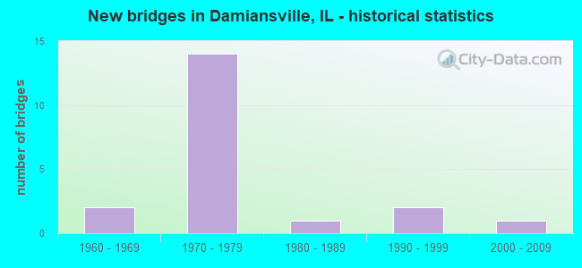
- New bridges - historical statistics
- 21960-1969
- 141970-1979
- 11980-1989
- 21990-1999
- 12000-2009


- Bridge Condition - Deck
- 11.1%Very good
- 88.9%Good

- Bridge Condition - Superstructure
- 11.1%Very good
- 77.8%Good
- 11.1%Satisfactory

- Bridge Condition - Substructure
- 22.2%Very good
- 55.6%Good
- 16.7%Satisfactory
- 5.6%Fair

- Bridge Condition - Channel
- 6.3%Excellent
- 50.0%Very good
- 43.8%Good
Find on map >> Show street view
Structure Number: 140037, Location: 3 MI S ALBERS (Lat: 38.500217, Lng: -89.611925), Route carried "on" structure: County highway , Year Built: 1971, Status: Open, Structure Length: 5.94m (19.49ft), Average Daily Traffic: 425 (year 2020), Truck Traffic: 9%, Average Future Daily Traffic: 2,432 (year 2032), Design Load: HS 20, Features Intersected: FAI 64, Facility Carried by Structure: Albers Rd-CH8-FAS7
Minimum Vertical Clearance: 30+ m (98+ ft), Kilometerpoint: 12.504, Lanes on structure: 2, Lanes under structure: 4, Owner: State Highway Agency, Approaching Roadway Width: 12.8m (42.0ft), Skew: 32 degrees, Material/Design: Steel continuous, Design/Construction: Stringer/Multi-beam, Number Of Spans In Main Unit: 2, Number Of Approach Spans: 2, Length of Maximum Span: 29.4m (96.5ft), Curb-To-Curb Width: 12.6m (41.3ft), Out-to-Out Width: 18.9m (62.0ft)
Condition: Deck: Good, Superstructure: Good, Substructure: Good, Operating Rating: 83.3 metric tons, Method Used To Determine Operating Rating: Load Factor (LF) rating reported by rating factor (RF) method using MS18 loading, Inventory Rating: 47.3 metric tons, Method Used To Determine Inventory Rating: Load Factor (LF) rating reported by rating factor (RF) method using MS18 loading, Structural Evaluation: Better than present minimum criteria, Deck Geometry: Superior to present desirable criteria, Underclear: Somewhat better than minimum adequacy, Approach Roadway Alignment: Equal to present desirable criteria, Designated Inspection Frequency: Every 24 months, Inspection Date: Febuary 2021, Deck Structure Type: Concrete Cast-file-Place, Wearing Surface/Protective System: Wearing Surface: Other
Find on map >> Show street view
Structure Number: 140039, Location: 1 MI W DAMIANSVILLE (Lat: 38.511511, Lng: -89.649081), Route carried "on" structure: County highway , Year Built: 1970, Status: Open, Structure Length: 5.74m (18.83ft), Average Daily Traffic: 250 (year 2020), Truck Traffic: 7%, Average Future Daily Traffic: 466 (year 2032), Design Load: HS 15, Features Intersected: FAI 64, Facility Carried by Structure: Billhartz Rd-FAS 7
Minimum Vertical Clearance: 30+ m (98+ ft), Kilometerpoint: 3.428, Lanes on structure: 2, Lanes under structure: 4, Owner: State Highway Agency, Approaching Roadway Width: 8.5m (27.9ft), Skew: 1 degrees, Material/Design: Steel continuous, Design/Construction: Stringer/Multi-beam, Number Of Spans In Main Unit: 2, Number Of Approach Spans: 2, Length of Maximum Span: 28.4m (93.2ft), Curb-To-Curb Width: 8.1m (26.6ft), Out-to-Out Width: 9.1m (29.9ft)
Condition: Deck: Good, Superstructure: Good, Substructure: Fair, Operating Rating: 77.4 metric tons, Method Used To Determine Operating Rating: Load Factor (LF) rating reported by rating factor (RF) method using MS18 loading, Inventory Rating: 41.1 metric tons, Method Used To Determine Inventory Rating: Load Factor (LF) rating reported by rating factor (RF) method using MS18 loading, Structural Evaluation: Somewhat better than minimum adequacy, Deck Geometry: Somewhat better than minimum adequacy, Underclear: Somewhat better than minimum adequacy, Approach Roadway Alignment: Equal to present minimum criteria, Designated Inspection Frequency: Every 24 months, Inspection Date: Febuary 2021, Deck Structure Type: Concrete Cast-file-Place, Wearing Surface/Protective System: Wearing Surface: Gravel
Find on map >> Show street view
Structure Number: 14004, Location: 1/2 mi W DAMIANSVLLE (Lat: 38.509542, Lng: -89.637425), Route carried "on" structure: Interstate 64, Year Built: 1971, Status: Open, Structure Length: 6.75m (22.15ft), Average Daily Traffic: 15,650 (year 2021), Truck Traffic: 32%, Average Future Daily Traffic: 11,799 (year 2032), Design Load: HS 20+Mod, Features Intersected: SUGAR CK OVERFLOW
Minimum Vertical Clearance: 30+ m (98+ ft), Kilometerpoint: 52.817, Lanes on structure: 2, Base Highway Network: Yes, Owner: State Highway Agency, Approaching Roadway Width: 13.4m (44.0ft), Material/Design: Steel continuous, Design/Construction: Stringer/Multi-beam, Number Of Spans In Main Unit: 3, Length of Maximum Span: 25.9m (85.0ft), Curb-To-Curb Width: 11.7m (38.4ft), Out-to-Out Width: 12.8m (42.0ft)
Condition: Deck: Good, Superstructure: Satisfactory, Substructure: Good, Channel: Good, Operating Rating: 67.7 metric tons, Method Used To Determine Operating Rating: Load Factor (LF) rating reported by rating factor (RF) method using MS18 loading, Inventory Rating: 40.5 metric tons, Method Used To Determine Inventory Rating: Load Factor (LF) rating reported by rating factor (RF) method using MS18 loading, Structural Evaluation: Equal to present minimum criteria, Deck Geometry: Equal to present minimum criteria, Waterway Adequacy: Superior to present desirable criteria, Approach Roadway Alignment: Equal to present desirable criteria, Designated Inspection Frequency: Every 24 months, Inspection Date: Febuary 2021, Deck Structure Type: Concrete Cast-file-Place, Wearing Surface/Protective System: Wearing Surface: Other
Find on map >> Show street view
Structure Number: 140041, Location: 1/2 mi W DAMIANSVLLE (Lat: 38.509514, Lng: -89.637233), Route carried "on" structure: Interstate 64, Year Built: 1971, Status: Open, Structure Length: 6.75m (22.15ft), Average Daily Traffic: 15,650 (year 2021), Truck Traffic: 32%, Average Future Daily Traffic: 11,799 (year 2032), Design Load: HS 20+Mod, Features Intersected: SUGAR CK OVERFLOW
Minimum Vertical Clearance: 30+ m (98+ ft), Kilometerpoint: 52.833, Lanes on structure: 2, Base Highway Network: Yes, Owner: State Highway Agency, Approaching Roadway Width: 13.4m (44.0ft), Material/Design: Steel continuous, Design/Construction: Stringer/Multi-beam, Number Of Spans In Main Unit: 3, Length of Maximum Span: 25.8m (84.6ft), Curb-To-Curb Width: 11.7m (38.4ft), Out-to-Out Width: 12.8m (42.0ft)
Condition: Deck: Good, Superstructure: Good, Substructure: Good, Channel: Good, Operating Rating: 67.7 metric tons, Method Used To Determine Operating Rating: Load Factor (LF) rating reported by rating factor (RF) method using MS18 loading, Inventory Rating: 40.5 metric tons, Method Used To Determine Inventory Rating: Load Factor (LF) rating reported by rating factor (RF) method using MS18 loading, Structural Evaluation: Better than present minimum criteria, Deck Geometry: Equal to present minimum criteria, Waterway Adequacy: Superior to present desirable criteria, Approach Roadway Alignment: Equal to present desirable criteria, Designated Inspection Frequency: Every 24 months, Underwater Inspection Frequency: Every 24 months, Inspection Date: Febuary 2021, Underwater Inspection Date: June 2021, Deck Structure Type: Concrete Cast-file-Place, Wearing Surface/Protective System: Wearing Surface: Other
Find on map >> Show street view
Structure Number: 140042, Location: 3.9 MI E COUNTY LINE (Lat: 38.509058, Lng: -89.634561), Route carried "on" structure: Interstate 64, Year Built: 1970, Status: Open, Structure Length: 6.75m (22.15ft), Average Daily Traffic: 15,650 (year 2021), Truck Traffic: 32%, Average Future Daily Traffic: 11,799 (year 2032), Design Load: HS 20+Mod, Features Intersected: SUGAR CREEK
Minimum Vertical Clearance: 30+ m (98+ ft), Kilometerpoint: 53.059, Lanes on structure: 2, Base Highway Network: Yes, Owner: State Highway Agency, Approaching Roadway Width: 13.4m (44.0ft), Material/Design: Steel continuous, Design/Construction: Stringer/Multi-beam, Number Of Spans In Main Unit: 3, Length of Maximum Span: 25.8m (84.6ft), Curb-To-Curb Width: 12.0m (39.4ft), Out-to-Out Width: 13.0m (42.7ft)
Condition: Deck: Good, Superstructure: Good, Substructure: Satisfactory, Channel: Good, Operating Rating: 59.9 metric tons, Method Used To Determine Operating Rating: Load Factor (LF) rating reported by rating factor (RF) method using MS18 loading, Inventory Rating: 32.1 metric tons, Method Used To Determine Inventory Rating: Load Factor (LF) rating reported by rating factor (RF) method using MS18 loading, Structural Evaluation: Equal to present minimum criteria, Deck Geometry: Equal to present minimum criteria, Waterway Adequacy: Superior to present desirable criteria, Approach Roadway Alignment: Equal to present desirable criteria, Designated Inspection Frequency: Every 24 months, Underwater Inspection Frequency: Every 24 months, Inspection Date: Febuary 2021, Underwater Inspection Date: August 2020, Deck Structure Type: Concrete Cast-file-Place, Wearing Surface/Protective System: Wearing Surface: Other
Find on map >> Show street view
Structure Number: 140043, Location: 3.9 MI EAST OF CL (Lat: 38.509019, Lng: -89.634372), Route carried "on" structure: Interstate 64, Year Built: 1970, Status: Open, Structure Length: 6.75m (22.15ft), Average Daily Traffic: 15,650 (year 2021), Truck Traffic: 32%, Average Future Daily Traffic: 11,799 (year 2032), Design Load: HS 20+Mod, Features Intersected: SUGAR CREEK
Minimum Vertical Clearance: 30+ m (98+ ft), Kilometerpoint: 53.075, Lanes on structure: 2, Base Highway Network: Yes, Owner: State Highway Agency, Approaching Roadway Width: 13.4m (44.0ft), Material/Design: Steel continuous, Design/Construction: Stringer/Multi-beam, Number Of Spans In Main Unit: 3, Length of Maximum Span: 25.8m (84.6ft), Curb-To-Curb Width: 12.0m (39.4ft), Out-to-Out Width: 13.0m (42.7ft)
Condition: Deck: Good, Superstructure: Good, Substructure: Good, Channel: Good, Operating Rating: 59.9 metric tons, Method Used To Determine Operating Rating: Load Factor (LF) rating reported by rating factor (RF) method using MS18 loading, Inventory Rating: 32.1 metric tons, Method Used To Determine Inventory Rating: Load Factor (LF) rating reported by rating factor (RF) method using MS18 loading, Structural Evaluation: Better than present minimum criteria, Deck Geometry: Equal to present minimum criteria, Waterway Adequacy: Superior to present desirable criteria, Approach Roadway Alignment: Equal to present desirable criteria, Designated Inspection Frequency: Every 24 months, Underwater Inspection Frequency: Every 24 months, Inspection Date: Febuary 2021, Underwater Inspection Date: August 2020, Deck Structure Type: Concrete Cast-file-Place, Wearing Surface/Protective System: Wearing Surface: Other
Find on map >> Show street view
Structure Number: 140044, Location: .75 W COUNTY LINE (Lat: 38.489172, Lng: -89.596775), Route carried "on" structure: Interstate 64, Year Built: 1970, Status: Open, Structure Length: 3.89m (12.76ft), Average Daily Traffic: 13,300 (year 2021), Truck Traffic: 29%, Average Future Daily Traffic: 9,936 (year 2032), Design Load: HS 20+Mod, Features Intersected: SYCAMORE DRAINAGE DT
Minimum Vertical Clearance: 30+ m (98+ ft), Kilometerpoint: 57.291, Lanes on structure: 2, Base Highway Network: Yes, Owner: State Highway Agency, Approaching Roadway Width: 13.4m (44.0ft), Material/Design: Steel continuous, Design/Construction: Stringer/Multi-beam, Number Of Spans In Main Unit: 2, Length of Maximum Span: 19.2m (63.0ft), Curb-To-Curb Width: 12.3m (40.4ft), Out-to-Out Width: 13.4m (44.0ft)
Condition: Deck: Good, Superstructure: Good, Substructure: Very good, Channel: Very good, Operating Rating: 78.1 metric tons, Method Used To Determine Operating Rating: Load Factor (LF) rating reported by rating factor (RF) method using MS18 loading, Inventory Rating: 46.3 metric tons, Method Used To Determine Inventory Rating: Load Factor (LF) rating reported by rating factor (RF) method using MS18 loading, Structural Evaluation: Better than present minimum criteria, Deck Geometry: Better than present minimum criteria, Waterway Adequacy: Superior to present desirable criteria, Approach Roadway Alignment: Equal to present desirable criteria, Designated Inspection Frequency: Every 24 months, Underwater Inspection Frequency: Every 24 months, Inspection Date: Febuary 2021, Underwater Inspection Date: June 2020, Deck Structure Type: Concrete Cast-file-Place, Wearing Surface/Protective System: Wearing Surface: Other
Find on map >> Show street view
Structure Number: 140045, Location: 3/4 MI WEST OF CL (Lat: 38.489058, Lng: -89.596647), Route carried "on" structure: Interstate 64, Year Built: 1970, Status: Open, Structure Length: 3.89m (12.76ft), Average Daily Traffic: 13,300 (year 2021), Truck Traffic: 29%, Average Future Daily Traffic: 9,936 (year 2032), Design Load: HS 20+Mod, Features Intersected: SYCAMORE DRAIN DITCH
Minimum Vertical Clearance: 30+ m (98+ ft), Kilometerpoint: 57.307, Lanes on structure: 2, Base Highway Network: Yes, Owner: State Highway Agency, Approaching Roadway Width: 13.4m (44.0ft), Material/Design: Steel continuous, Design/Construction: Stringer/Multi-beam, Number Of Spans In Main Unit: 2, Length of Maximum Span: 19.2m (63.0ft), Curb-To-Curb Width: 12.3m (40.4ft), Out-to-Out Width: 13.4m (44.0ft)
Condition: Deck: Good, Superstructure: Good, Substructure: Good, Channel: Very good, Operating Rating: 78.1 metric tons, Method Used To Determine Operating Rating: Load Factor (LF) rating reported by rating factor (RF) method using MS18 loading, Inventory Rating: 46.3 metric tons, Method Used To Determine Inventory Rating: Load Factor (LF) rating reported by rating factor (RF) method using MS18 loading, Structural Evaluation: Better than present minimum criteria, Deck Geometry: Better than present minimum criteria, Waterway Adequacy: Equal to present desirable criteria, Approach Roadway Alignment: Superior to present desirable criteria, Designated Inspection Frequency: Every 24 months, Underwater Inspection Frequency: Every 24 months, Inspection Date: Febuary 2021, Underwater Inspection Date: June 2020, Deck Structure Type: Concrete Cast-file-Place, Wearing Surface/Protective System: Wearing Surface: Other
Find on map >> Show street view
Structure Number: 140046, Location: 1/4 mi W COUNTY LINE (Lat: 38.482378, Lng: -89.587406), Route carried "on" structure: Interstate 64, Year Built: 1970, Status: Open, Structure Length: 11.36m (37.27ft), Average Daily Traffic: 13,300 (year 2021), Truck Traffic: 29%, Average Future Daily Traffic: 9,936 (year 2032), Design Load: HS 20+Mod, Features Intersected: KASKASKIA R OVERFLOW
Minimum Vertical Clearance: 30+ m (98+ ft), Kilometerpoint: 58.353, Lanes on structure: 2, Base Highway Network: Yes, Owner: State Highway Agency, Approaching Roadway Width: 13.4m (44.0ft), Skew: 3 degrees, Material/Design: Steel continuous, Design/Construction: Stringer/Multi-beam, Number Of Spans In Main Unit: 6, Length of Maximum Span: 20.3m (66.6ft), Curb-To-Curb Width: 11.9m (39.0ft), Out-to-Out Width: 13.0m (42.7ft)
Condition: Deck: Good, Superstructure: Good, Substructure: Good, Channel: Very good, Operating Rating: 53.8 metric tons, Method Used To Determine Operating Rating: Load Factor (LF) rating reported by rating factor (RF) method using MS18 loading, Inventory Rating: 32.1 metric tons, Method Used To Determine Inventory Rating: Load Factor (LF) rating reported by rating factor (RF) method using MS18 loading, Structural Evaluation: Better than present minimum criteria, Deck Geometry: Equal to present minimum criteria, Waterway Adequacy: Superior to present desirable criteria, Approach Roadway Alignment: Equal to present desirable criteria, Designated Inspection Frequency: Every 24 months, Inspection Date: Febuary 2021, Deck Structure Type: Concrete Cast-file-Place, Wearing Surface/Protective System: Wearing Surface: Other
Find on map >> Show street view
Structure Number: 140047, Location: 1/4 mi W County Line (Lat: 38.481972, Lng: -89.586831), Route carried "on" structure: Interstate 64, Year Built: 1970, Status: Open, Structure Length: 11.62m (38.12ft), Average Daily Traffic: 13,300 (year 2021), Truck Traffic: 29%, Average Future Daily Traffic: 9,936 (year 2032), Design Load: HS 20+Mod, Features Intersected: KASKASKIA OVERFLOW
Minimum Vertical Clearance: 30+ m (98+ ft), Kilometerpoint: 58.418, Lanes on structure: 2, Base Highway Network: Yes, Owner: State Highway Agency, Approaching Roadway Width: 13.4m (44.0ft), Skew: 3 degrees, Material/Design: Steel continuous, Design/Construction: Stringer/Multi-beam, Number Of Spans In Main Unit: 6, Length of Maximum Span: 20.7m (67.9ft), Curb-To-Curb Width: 11.9m (39.0ft), Out-to-Out Width: 13.0m (42.7ft)
Condition: Deck: Good, Superstructure: Good, Substructure: Very good, Channel: Very good, Operating Rating: 56.4 metric tons, Method Used To Determine Operating Rating: Load Factor (LF) rating reported by rating factor (RF) method using MS18 loading, Inventory Rating: 33.7 metric tons, Method Used To Determine Inventory Rating: Load Factor (LF) rating reported by rating factor (RF) method using MS18 loading, Structural Evaluation: Better than present minimum criteria, Deck Geometry: Equal to present minimum criteria, Waterway Adequacy: Superior to present desirable criteria, Approach Roadway Alignment: Equal to present desirable criteria, Designated Inspection Frequency: Every 24 months, Inspection Date: Febuary 2021, Deck Structure Type: Concrete Cast-file-Place, Wearing Surface/Protective System: Wearing Surface: Other
Find on map >> Show street view
Structure Number: 140073, Location: 1 MI E NEW MEMPHIS (Lat: 38.458756, Lng: -89.658456), Route carried "on" structure: State highway 160, Year Built: 1997, Status: Open, Structure Length: 14.65m (48.06ft), Average Daily Traffic: 1,900 (year 2021), Truck Traffic: 10%, Average Future Daily Traffic: 1,915 (year 2032), Design Load: HS 20, Features Intersected: QUEEN'S LAKE SLOUGH
Minimum Vertical Clearance: 30+ m (98+ ft), Kilometerpoint: 21.098, Lanes on structure: 2, Base Highway Network: Yes, Owner: State Highway Agency, Approaching Roadway Width: 9.8m (32.2ft), Material/Design: Prestressed concrete, Design/Construction: Stringer/Multi-beam, Number Of Spans In Main Unit: 5, Length of Maximum Span: 32.1m (105.3ft), Curb-To-Curb Width: 9.8m (32.2ft), Out-to-Out Width: 10.7m (35.1ft)
Condition: Deck: Good, Superstructure: Good, Substructure: Very good, Channel: Very good, Operating Rating: 59.3 metric tons, Method Used To Determine Operating Rating: Load Factor (LF) rating reported by rating factor (RF) method using MS18 loading, Inventory Rating: 37.3 metric tons, Method Used To Determine Inventory Rating: Load Factor (LF) rating reported by rating factor (RF) method using MS18 loading, Structural Evaluation: Better than present minimum criteria, Deck Geometry: Somewhat better than minimum adequacy, Waterway Adequacy: Equal to present desirable criteria, Approach Roadway Alignment: Equal to present desirable criteria, Designated Inspection Frequency: Every 24 months, Inspection Date: July 2020, Deck Structure Type: Concrete Cast-file-Place, Wearing Surface/Protective System: Deck Protection: Epoxy Coated Reinforcing
Find on map >> Show street view
Structure Number: 140074, Location: 1.2M E of NEW MEMPHI (Lat: 38.457850, Lng: -89.651222), Route carried "on" structure: State highway 160, Year Built: 1997, Status: Open, Structure Length: 8.71m (28.58ft), Average Daily Traffic: 1,900 (year 2021), Truck Traffic: 10%, Average Future Daily Traffic: 1,915 (year 2032), Design Load: HS 20, Features Intersected: KASKASKIA OVERFLOW
Minimum Vertical Clearance: 30+ m (98+ ft), Kilometerpoint: 20.454, Lanes on structure: 2, Base Highway Network: Yes, Owner: State Highway Agency, Approaching Roadway Width: 9.8m (32.2ft), Material/Design: Prestressed concrete, Design/Construction: Stringer/Multi-beam, Number Of Spans In Main Unit: 3, Length of Maximum Span: 29.1m (95.5ft), Curb-To-Curb Width: 9.8m (32.2ft), Out-to-Out Width: 10.7m (35.1ft)
Condition: Deck: Very good, Superstructure: Very good, Substructure: Very good, Channel: Very good, Operating Rating: 76.1 metric tons, Method Used To Determine Operating Rating: Load Factor (LF) rating reported by rating factor (RF) method using MS18 loading, Inventory Rating: 45.4 metric tons, Method Used To Determine Inventory Rating: Load Factor (LF) rating reported by rating factor (RF) method using MS18 loading, Structural Evaluation: Equal to present desirable criteria, Deck Geometry: Somewhat better than minimum adequacy, Waterway Adequacy: Equal to present desirable criteria, Approach Roadway Alignment: Equal to present desirable criteria, Designated Inspection Frequency: Every 48 months, Inspection Date: July 2020, Deck Structure Type: Concrete Cast-file-Place, Wearing Surface/Protective System: Deck Protection: Epoxy Coated Reinforcing
Find on map >> Show street view
Structure Number: 144027, Location: SOF I64-INTERCHANGE (Lat: 38.495378, Lng: -89.637006), Route carried "on" structure: County highway , Year Built: 1983, Status: Open, Structure Length: 4.60m (15.09ft), Average Daily Traffic: 450 (year 2020), Truck Traffic: 18%, Average Future Daily Traffic: 311 (year 2032), Design Load: HS 20, Features Intersected: SUGAR CREEK, Facility Carried by Structure: TR 211/AIRPORT ROA
Minimum Vertical Clearance: 30+ m (98+ ft), Kilometerpoint: 6.131, Lanes on structure: 2, Owner: Town or Township Highway Agency, Approaching Roadway Width: 6.1m (20.0ft), Skew: 4 degrees, Material/Design: Prestressed concrete, Design/Construction: Box Beam or Girders - Multiple, Number Of Spans In Main Unit: 3, Length of Maximum Span: 15.2m (49.9ft), Curb-To-Curb Width: 8.3m (27.2ft), Out-to-Out Width: 8.3m (27.2ft)
Condition: Deck: Very good, Superstructure: Very good, Substructure: Good, Channel: Good, Operating Rating: 44.4 metric tons, Method Used To Determine Operating Rating: Assigned rating based on Load Factor Design (LFD) reported by rating factor (RF) using MS18 loading, Inventory Rating: 32.4 metric tons, Method Used To Determine Inventory Rating: Assigned rating based on Load Factor Design (LFD) reported by rating factor (RF) using MS18 loading, Structural Evaluation: Better than present minimum criteria, Deck Geometry: Somewhat better than minimum adequacy, Waterway Adequacy: Somewhat better than minimum adequacy, Approach Roadway Alignment: Equal to present minimum criteria, Designated Inspection Frequency: Every 48 months, Inspection Date: June 2021, Deck Structure Type: Concrete Precast Panels, Wearing Surface/Protective System: Wearing Surface: Integral Concrete, Deck Protection: Epoxy Coated Reinforcing
Find on map >> Show street view
Structure Number: 145103, Location: .5 MI W DAMIANSVILLE (Lat: 38.513608, Lng: -89.635803), Route carried "on" structure: County highway , Year Built: 2004, Status: Open, Structure Length: 9.18m (30.12ft), Average Daily Traffic: 550 (year 2020), Truck Traffic: 8%, Average Future Daily Traffic: 569 (year 2032), Design Load: HS 20, Features Intersected: SUGAR CREEK, Facility Carried by Structure: DAMIANSVILLE RD
Minimum Vertical Clearance: 30+ m (98+ ft), Kilometerpoint: 4.844, Lanes on structure: 2, Owner: County Highway Agency, Approaching Roadway Width: 6.7m (22.0ft), Skew: 1 degrees, Material/Design: Prestressed concrete, Design/Construction: Box Beam or Girders - Multiple, Number Of Spans In Main Unit: 5, Length of Maximum Span: 18.3m (60.0ft), Curb-To-Curb Width: 9.3m (30.5ft), Out-to-Out Width: 9.3m (30.5ft)
Condition: Deck: Good, Superstructure: Satisfactory, Substructure: Good, Channel: Excellent, Operating Rating: 44.1 metric tons, Method Used To Determine Operating Rating: Assigned rating based on Load Factor Design (LFD) reported by rating factor (RF) using MS18 loading, Inventory Rating: 32.4 metric tons, Method Used To Determine Inventory Rating: Assigned rating based on Load Factor Design (LFD) reported by rating factor (RF) using MS18 loading, Structural Evaluation: Equal to present minimum criteria, Deck Geometry: Equal to present minimum criteria, Waterway Adequacy: Equal to present desirable criteria, Approach Roadway Alignment: Equal to present desirable criteria, Designated Inspection Frequency: Every 24 months, Inspection Date: September 2021, Deck Structure Type: Concrete Precast Panels, Wearing Surface/Protective System: Wearing Surface: Bituminous, Membrane: Built-up, Deck Protection: Other
Find on map >> Show street view
Structure Number: 950039, Location: CLINTON CO LINE (Lat: 38.478719, Lng: -89.582247), Route carried "on" structure: Interstate 64, Year Built: 1971, Status: Open, Structure Length: 8.81m (28.90ft), Average Daily Traffic: 14,750 (year 2021), Truck Traffic: 26%, Average Future Daily Traffic: 10,750 (year 2032), Design Load: HS 20+Mod, Features Intersected: KASKASKIA RIVER
Minimum Vertical Clearance: 30+ m (98+ ft), Kilometerpoint: 58.933, Lanes on structure: 2, Base Highway Network: Yes, Owner: State Highway Agency, Approaching Roadway Width: 13.4m (44.0ft), Skew: 2 degrees, Material/Design: Steel continuous, Design/Construction: Stringer/Multi-beam, Number Of Spans In Main Unit: 3, Length of Maximum Span: 33.7m (110.6ft), Curb-To-Curb Width: 11.9m (39.0ft), Out-to-Out Width: 13.0m (42.7ft)
Condition: Deck: Good, Superstructure: Good, Substructure: Satisfactory, Channel: Good, Operating Rating: 63.2 metric tons, Method Used To Determine Operating Rating: Load Factor (LF) rating reported by rating factor (RF) method using MS18 loading, Inventory Rating: 37.9 metric tons, Method Used To Determine Inventory Rating: Load Factor (LF) rating reported by rating factor (RF) method using MS18 loading, Structural Evaluation: Equal to present minimum criteria, Deck Geometry: Equal to present minimum criteria, Waterway Adequacy: Superior to present desirable criteria, Approach Roadway Alignment: Equal to present desirable criteria, Designated Inspection Frequency: Every 24 months, Inspection Date: Febuary 2021, Deck Structure Type: Concrete Cast-file-Place, Wearing Surface/Protective System: Wearing Surface: Other
Find on map >> Show street view
Structure Number: 95004, Location: CLINTON CO LINE (Lat: 38.478617, Lng: -89.582114), Route carried "on" structure: Interstate 64, Year Built: 1971, Status: Open, Structure Length: 8.81m (28.90ft), Average Daily Traffic: 14,750 (year 2021), Truck Traffic: 26%, Average Future Daily Traffic: 10,750 (year 2032), Design Load: HS 20, Features Intersected: KASKASKIA RIVER
Minimum Vertical Clearance: 30+ m (98+ ft), Kilometerpoint: 58.949, Lanes on structure: 2, Base Highway Network: Yes, Owner: State Highway Agency, Approaching Roadway Width: 13.4m (44.0ft), Skew: 2 degrees, Material/Design: Steel continuous, Design/Construction: Stringer/Multi-beam, Number Of Spans In Main Unit: 3, Length of Maximum Span: 33.7m (110.6ft), Curb-To-Curb Width: 11.9m (39.0ft), Out-to-Out Width: 13.0m (42.7ft)
Condition: Deck: Good, Superstructure: Good, Substructure: Satisfactory, Channel: Good, Operating Rating: 63.2 metric tons, Method Used To Determine Operating Rating: Load Factor (LF) rating reported by rating factor (RF) method using MS18 loading, Inventory Rating: 37.9 metric tons, Method Used To Determine Inventory Rating: Load Factor (LF) rating reported by rating factor (RF) method using MS18 loading, Structural Evaluation: Equal to present minimum criteria, Deck Geometry: Equal to present minimum criteria, Waterway Adequacy: Superior to present desirable criteria, Approach Roadway Alignment: Better than present minimum criteria, Designated Inspection Frequency: Every 24 months, Inspection Date: Febuary 2021, Deck Structure Type: Concrete Cast-file-Place, Wearing Surface/Protective System: Wearing Surface: Other
Find on map >> Show street view
Structure Number: 950041, Location: 0.2 MI E OF CO LINE (Lat: 38.476722, Lng: -89.579789), Route carried "on" structure: Interstate 64, Year Built: 1969, Status: Open, Structure Length: 10.23m (33.56ft), Average Daily Traffic: 14,750 (year 2021), Truck Traffic: 26%, Average Future Daily Traffic: 10,750 (year 2032), Design Load: HS 20+Mod, Features Intersected: KASKASKIA R OVERFLOW
Minimum Vertical Clearance: 30+ m (98+ ft), Kilometerpoint: 59.238, Lanes on structure: 2, Base Highway Network: Yes, Owner: State Highway Agency, Approaching Roadway Width: 13.4m (44.0ft), Skew: 2 degrees, Material/Design: Steel continuous, Design/Construction: Stringer/Multi-beam, Number Of Spans In Main Unit: 5, Length of Maximum Span: 22.3m (73.2ft), Curb-To-Curb Width: 11.9m (39.0ft), Out-to-Out Width: 13.0m (42.7ft)
Condition: Deck: Good, Superstructure: Good, Substructure: Good, Channel: Very good, Operating Rating: 55.7 metric tons, Method Used To Determine Operating Rating: Load Factor (LF) rating reported by rating factor (RF) method using MS18 loading, Inventory Rating: 33.4 metric tons, Method Used To Determine Inventory Rating: Load Factor (LF) rating reported by rating factor (RF) method using MS18 loading, Structural Evaluation: Better than present minimum criteria, Deck Geometry: Equal to present minimum criteria, Waterway Adequacy: Equal to present desirable criteria, Approach Roadway Alignment: Equal to present desirable criteria, Designated Inspection Frequency: Every 24 months, Other Special Inspection Frequency: Every 24 months, Inspection Date: Febuary 2021, Other Special Inspection Date: October 2021, Deck Structure Type: Concrete Cast-file-Place, Wearing Surface/Protective System: Wearing Surface: Other
Find on map >> Show street view
Structure Number: 950042, Location: 0.2 MI E OF CO LINE (Lat: 38.476500, Lng: -89.579544), Route carried "on" structure: Interstate 64, Year Built: 1969, Status: Open, Structure Length: 10.24m (33.60ft), Average Daily Traffic: 14,750 (year 2021), Truck Traffic: 26%, Average Future Daily Traffic: 10,750 (year 2032), Design Load: HS 20+Mod, Features Intersected: KASKASKIA R OVERFLOW
Minimum Vertical Clearance: 30+ m (98+ ft), Kilometerpoint: 59.271, Lanes on structure: 2, Base Highway Network: Yes, Owner: State Highway Agency, Approaching Roadway Width: 13.4m (44.0ft), Skew: 2 degrees, Material/Design: Steel continuous, Design/Construction: Stringer/Multi-beam, Number Of Spans In Main Unit: 5, Length of Maximum Span: 22.3m (73.2ft), Curb-To-Curb Width: 11.9m (39.0ft), Out-to-Out Width: 13.0m (42.7ft)
Condition: Deck: Good, Superstructure: Good, Substructure: Good, Channel: Very good, Operating Rating: 55.7 metric tons, Method Used To Determine Operating Rating: Load Factor (LF) rating reported by rating factor (RF) method using MS18 loading, Inventory Rating: 33.4 metric tons, Method Used To Determine Inventory Rating: Load Factor (LF) rating reported by rating factor (RF) method using MS18 loading, Structural Evaluation: Better than present minimum criteria, Deck Geometry: Equal to present minimum criteria, Waterway Adequacy: Superior to present desirable criteria, Approach Roadway Alignment: Equal to present desirable criteria, Designated Inspection Frequency: Every 24 months, Other Special Inspection Frequency: Every 24 months, Inspection Date: Febuary 2021, Other Special Inspection Date: October 2021, Deck Structure Type: Concrete Cast-file-Place, Wearing Surface/Protective System: Wearing Surface: Other
Find on map >> Show street view
Structure Number: 140037, Location: 3 MI S ALBERS (Lat: 38.500217, Lng: -89.611925), Route carried "under" structure: Interstate 64, Year Built: 1971, Structure Length: 0. m, Average Daily Traffic: 26,600 (year 2021), Truck Traffic: 29%, Features Intersected: FAI 64, Facility Carried by Structure: Albers Rd-CH8-FAS7
Minimum Vertical Clearance: 5.03m (16.50ft), Kilometerpoint: 55.360, Lanes on structure: 2, Lanes under structure: 4, Material/Design: Steel continuous, Design/Construction: Stringer/Multi-beam, Length of Maximum Span: 29.4m (96.5ft)
Find on map >> Show street view
Structure Number: 140039, Location: 1 MI W DAMIANSVILLE (Lat: 38.511511, Lng: -89.649081), Route carried "under" structure: Interstate 64, Year Built: 1970, Structure Length: 0. m, Average Daily Traffic: 31,300 (year 2021), Truck Traffic: 32%, Features Intersected: FAI 64, Facility Carried by Structure: Billhartz Rd-FAS 7
Minimum Vertical Clearance: 4.95m (16.24ft), Kilometerpoint: 51.836, Lanes on structure: 2, Lanes under structure: 4, Material/Design: Steel continuous, Design/Construction: Stringer/Multi-beam, Length of Maximum Span: 28.4m (93.2ft)