Bridge Statistics for Cullom, Illinois (IL)
Condition, Traffic, Stress, Structural Evaluation, Project Costs
- National Bridge Inventory (NBI) Statistics
- 20Number of bridges
- 164ft / 50.3mTotal length
- 2,110Total average daily traffic
- 322Total average daily truck traffic
- 2,577Total future (year 2032) average daily traffic
- National Bridge Inventory (NBI) Registered Bridges for Cullom
- No street view available for this location
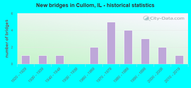
- New bridges - historical statistics
- 11920-1929
- 11930-1939
- 11940-1949
- 21960-1969
- 51970-1979
- 41980-1989
- 31990-1999
- 22000-2009
- 12010-2019

- Reconstructed bridges - Historical Statistics
- 11980-1989
- 11990-1999


- Bridge Condition - Deck
- 33.3%Very good
- 50.0%Good
- 11.1%Satisfactory
- 5.6%Poor

- Bridge Condition - Superstructure
- 38.9%Very good
- 44.4%Good
- 11.1%Satisfactory
- 5.6%Poor

- Bridge Condition - Substructure
- 61.1%Very good
- 27.8%Good
- 5.6%Satisfactory
- 5.6%Fair

- Bridge Condition - Channel
- 5.0%Excellent
- 45.0%Very good
- 35.0%Good
- 15.0%Satisfactory
Find on map >> Show street view
Structure Number: 273243, Location: 1350E 3200N (Lat: 40.864294, Lng: -88.215336), Route carried "on" structure: County highway , Year Built: 1976, Status: Open, Structure Length: 2.29m (7.51ft), Average Daily Traffic: 50 (year 2019), Average Future Daily Traffic: 53 (year 2032), Design Load: HS 20, Features Intersected: STREAM, Facility Carried by Structure: TR 13 MONA
Minimum Vertical Clearance: 30+ m (98+ ft), Kilometerpoint: 2.317, Lanes on structure: 2, Owner: Town or Township Highway Agency, Approaching Roadway Width: 5.5m (18.0ft), Skew: 4 degrees, Material/Design: Prestressed concrete, Design/Construction: Box Beam or Girders - Multiple, Number Of Spans In Main Unit: 3, Length of Maximum Span: 7.6m (24.9ft), Curb-To-Curb Width: 6.9m (22.6ft), Out-to-Out Width: 8.0m (26.2ft)
Condition: Deck: Good, Superstructure: Good, Substructure: Good, Channel: Good, Operating Rating: 44.4 metric tons, Method Used To Determine Operating Rating: Assigned rating based on Load Factor Design (LFD) reported by rating factor (RF) using MS18 loading, Inventory Rating: 32.4 metric tons, Method Used To Determine Inventory Rating: Assigned rating based on Load Factor Design (LFD) reported by rating factor (RF) using MS18 loading, Structural Evaluation: Better than present minimum criteria, Deck Geometry: Somewhat better than minimum adequacy, Waterway Adequacy: Equal to present minimum criteria, Approach Roadway Alignment: Equal to present desirable criteria, Designated Inspection Frequency: Every 48 months, Inspection Date: April 2021, Deck Structure Type: Concrete Precast Panels, Wearing Surface/Protective System: Wearing Surface: Gravel
Find on map >> Show street view
Structure Number: 273244, Location: 3160N 1300E (Lat: 40.858297, Lng: -88.224008), Route carried "on" structure: County highway , Year Built: 1976, Status: Open, Structure Length: 1.74m (5.71ft), Average Daily Traffic: 50 (year 2019), Average Future Daily Traffic: 53 (year 2032), Design Load: HS 20, Features Intersected: STREAM, Facility Carried by Structure: TR 48 MONA
Minimum Vertical Clearance: 30+ m (98+ ft), Kilometerpoint: 15.288, Lanes on structure: 2, Owner: Town or Township Highway Agency, Approaching Roadway Width: 6.0m (19.7ft), Skew: 3 degrees, Material/Design: Prestressed concrete, Design/Construction: Box Beam or Girders - Multiple, Number Of Spans In Main Unit: 1, Length of Maximum Span: 17.1m (56.1ft), Curb-To-Curb Width: 7.2m (23.6ft), Out-to-Out Width: 8.3m (27.2ft)
Condition: Deck: Very good, Superstructure: Very good, Substructure: Very good, Channel: Very good, Operating Rating: 44.4 metric tons, Method Used To Determine Operating Rating: Assigned rating based on Load Factor Design (LFD) reported by rating factor (RF) using MS18 loading, Inventory Rating: 32.4 metric tons, Method Used To Determine Inventory Rating: Assigned rating based on Load Factor Design (LFD) reported by rating factor (RF) using MS18 loading, Structural Evaluation: Equal to present desirable criteria, Deck Geometry: Somewhat better than minimum adequacy, Waterway Adequacy: Better than present minimum criteria, Approach Roadway Alignment: Equal to present desirable criteria, Designated Inspection Frequency: Every 48 months, Inspection Date: April 2021, Deck Structure Type: Concrete Precast Panels, Wearing Surface/Protective System: Wearing Surface: Gravel
Find on map >> Show street view
Structure Number: 273338, Location: 2990N,1300E (Lat: 40.832964, Lng: -88.222986), Route carried "on" structure: County highway , Year Built: 1983, Status: Open, Structure Length: 3.54m (11.61ft), Average Daily Traffic: 50 (year 2019), Average Future Daily Traffic: 53 (year 2032), Design Load: HS 20, Features Intersected: KELLY CREEK, Facility Carried by Structure: TR 48 PELLA
Minimum Vertical Clearance: 30+ m (98+ ft), Kilometerpoint: 18.137, Lanes on structure: 2, Owner: Town or Township Highway Agency, Approaching Roadway Width: 5.2m (17.1ft), Skew: 1 degrees, Material/Design: Concrete, Design/Construction: Channel Beam, Number Of Spans In Main Unit: 3, Length of Maximum Span: 11.6m (38.1ft), Curb-To-Curb Width: 8.0m (26.2ft), Out-to-Out Width: 8.0m (26.2ft)
Condition: Deck: Good, Superstructure: Good, Substructure: Good, Channel: Good, Operating Rating: 44.4 metric tons, Method Used To Determine Operating Rating: Assigned rating based on Load Factor Design (LFD) reported by rating factor (RF) using MS18 loading, Inventory Rating: 32.4 metric tons, Method Used To Determine Inventory Rating: Assigned rating based on Load Factor Design (LFD) reported by rating factor (RF) using MS18 loading, Structural Evaluation: Better than present minimum criteria, Deck Geometry: Equal to present minimum criteria, Waterway Adequacy: Equal to present desirable criteria, Approach Roadway Alignment: Equal to present desirable criteria, Designated Inspection Frequency: Every 48 months, Inspection Date: April 2021, Deck Structure Type: Concrete Precast Panels, Wearing Surface/Protective System: Wearing Surface: Gravel
Find on map >> Show street view
Structure Number: 273408, Location: 1210E,2900N (Lat: 40.820286, Lng: -88.239111), Route carried "on" structure: County highway , Year Built: 1996, Status: Open, Structure Length: 2.23m (7.32ft), Average Daily Traffic: 50 (year 2019), Average Future Daily Traffic: 53 (year 2032), Design Load: HS 20, Features Intersected: STREAM, Facility Carried by Structure: TR 19
Minimum Vertical Clearance: 30+ m (98+ ft), Kilometerpoint: 0.177, Lanes on structure: 2, Owner: Town or Township Highway Agency, Approaching Roadway Width: 7.3m (24.0ft), Material/Design: Prestressed concrete, Design/Construction: Box Beam or Girders - Multiple, Number Of Spans In Main Unit: 1, Length of Maximum Span: 21.6m (70.9ft), Curb-To-Curb Width: 8.2m (26.9ft), Out-to-Out Width: 8.2m (26.9ft)
Condition: Deck: Poor, Superstructure: Poor, Substructure: Very good, Channel: Good, Operating Rating: 53.5 metric tons, Method Used To Determine Operating Rating: Load Factor (LF) rating reported by rating factor (RF) method using MS18 loading, Inventory Rating: 20.1 metric tons, Method Used To Determine Inventory Rating: Load Factor (LF) rating reported by rating factor (RF) method using MS18 loading, Structural Evaluation: Meets minimum limits, Deck Geometry: Equal to present minimum criteria, Waterway Adequacy: Better than present minimum criteria, Approach Roadway Alignment: Equal to present desirable criteria, Designated Inspection Frequency: Every 24 months, Inspection Date: April 2021, Deck Structure Type: Concrete Precast Panels, Wearing Surface/Protective System: Wearing Surface: Gravel
Find on map >> Show street view
Structure Number: 533003, Location: 5 MI N OF CHATSWORTH (Lat: 40.835594, Lng: -88.298919), Route carried "on" structure: County highway , Year Built: 1936, Year Reconstructed: 1989, Status: Open, Structure Length: 7.73m (25.36ft), Average Daily Traffic: 500 (year 2019), Truck Traffic: 24%, Average Future Daily Traffic: 710 (year 2032), Design Load: HS 20, Features Intersected: NORTH FORK VERMILION, Facility Carried by Structure: CH-3 (FAS-343)
Minimum Vertical Clearance: 30+ m (98+ ft), Kilometerpoint: 28.935, Lanes on structure: 2, Owner: County Highway Agency, Approaching Roadway Width: 9.8m (32.2ft), Material/Design: Steel continuous, Design/Construction: Stringer/Multi-beam, Number Of Spans In Main Unit: 4, Length of Maximum Span: 21.3m (69.9ft), Curb-To-Curb Width: 8.7m (28.5ft), Out-to-Out Width: 8.7m (28.5ft)
Condition: Deck: Good, Superstructure: Very good, Substructure: Very good, Channel: Good, Operating Rating: 57.7 metric tons, Method Used To Determine Operating Rating: Load Factor (LF) rating reported by rating factor (RF) method using MS18 loading, Inventory Rating: 34.3 metric tons, Method Used To Determine Inventory Rating: Load Factor (LF) rating reported by rating factor (RF) method using MS18 loading, Structural Evaluation: Equal to present desirable criteria, Deck Geometry: Somewhat better than minimum adequacy, Waterway Adequacy: Superior to present desirable criteria, Approach Roadway Alignment: Equal to present desirable criteria, Designated Inspection Frequency: Every 24 months, Inspection Date: October 2021, Deck Structure Type: Concrete Cast-file-Place, Wearing Surface/Protective System: Deck Protection: Epoxy Coated Reinforcing
Find on map >> Show street view
Structure Number: 533151, Location: 1520 N, 3600 E (Lat: 40.845172, Lng: -88.242164), Route carried "on" structure: County highway , Year Built: 1972, Status: Open, Structure Length: 1.95m (6.40ft), Average Daily Traffic: 10 (year 2019), Average Future Daily Traffic: 11 (year 2032), Design Load: HS 15, Features Intersected: STREAM, Facility Carried by Structure: TR 42
Minimum Vertical Clearance: 30+ m (98+ ft), Kilometerpoint: 16.656, Lanes on structure: 2, Owner: Town or Township Highway Agency, Approaching Roadway Width: 3.7m (12.1ft), Material/Design: Concrete continuous, Design/Construction: Slab, Number Of Spans In Main Unit: 3, Length of Maximum Span: 7.0m (23.0ft), Curb-To-Curb Width: 7.3m (24.0ft), Out-to-Out Width: 7.9m (25.9ft)
Condition: Deck: Good, Superstructure: Good, Substructure: Good, Channel: Good, Operating Rating: 41.5 metric tons, Method Used To Determine Operating Rating: Load Factor (LF) rating reported by rating factor (RF) method using MS18 loading, Inventory Rating: 24.9 metric tons, Method Used To Determine Inventory Rating: Load Factor (LF) rating reported by rating factor (RF) method using MS18 loading, Structural Evaluation: Equal to present minimum criteria, Deck Geometry: Equal to present minimum criteria, Waterway Adequacy: Equal to present minimum criteria, Approach Roadway Alignment: Equal to present desirable criteria, Designated Inspection Frequency: Every 24 months, Inspection Date: June 2020, Deck Structure Type: Concrete Cast-file-Place
Find on map >> Show street view
Structure Number: 533409, Location: 1520 N, 3500 E (Lat: 40.851892, Lng: -88.261467), Route carried "on" structure: County highway , Year Built: 1945, Status: Open, Structure Length: 0.76m (2.49ft), Average Daily Traffic: 100 (year 2019), Truck Traffic: 10%, Average Future Daily Traffic: 76 (year 2032), Features Intersected: DRAINAGE DITCH, Facility Carried by Structure: TR 282A
Minimum Vertical Clearance: 30+ m (98+ ft), Kilometerpoint: 2.784, Lanes on structure: 1, Owner: Town or Township Highway Agency, Approaching Roadway Width: 5.2m (17.1ft), Material/Design: Steel, Design/Construction: Stringer/Multi-beam, Number Of Spans In Main Unit: 1, Length of Maximum Span: 7.3m (24.0ft), Curb-To-Curb Width: 7.3m (24.0ft), Out-to-Out Width: 8.0m (26.2ft)
Condition: Deck: Good, Superstructure: Good, Substructure: Good, Channel: Good, Operating Rating: 32.4 metric tons, Method Used To Determine Operating Rating: Allowable Stress (AS) rating reported by rating factor (RF) method using MS18 loading, Inventory Rating: 26.2 metric tons, Method Used To Determine Inventory Rating: Allowable Stress (AS) rating reported by rating factor (RF) method using MS18 loading, Structural Evaluation: Equal to present minimum criteria, Deck Geometry: Equal to present minimum criteria, Waterway Adequacy: Equal to present minimum criteria, Approach Roadway Alignment: Equal to present desirable criteria, Designated Inspection Frequency: Every 24 months, Inspection Date: June 2020, Deck Structure Type: Concrete Cast-file-Place
Find on map >> Show street view
Structure Number: 53341, Location: 1430 N, 3500 E (Lat: 40.839006, Lng: -88.260958), Route carried "on" structure: County highway , Year Built: 1961, Status: Open, Structure Length: 2.35m (7.71ft), Average Daily Traffic: 100 (year 2019), Truck Traffic: 10%, Average Future Daily Traffic: 76 (year 2032), Design Load: HS 15, Features Intersected: N FORK VERMILION R, Facility Carried by Structure: TR 282A
Minimum Vertical Clearance: 30+ m (98+ ft), Kilometerpoint: 4.216, Lanes on structure: 2, Owner: Town or Township Highway Agency, Approaching Roadway Width: 5.0m (16.4ft), Skew: 3 degrees, Material/Design: Concrete continuous, Design/Construction: Slab, Number Of Spans In Main Unit: 3, Length of Maximum Span: 8.8m (28.9ft), Curb-To-Curb Width: 7.3m (24.0ft), Out-to-Out Width: 8.8m (28.9ft)
Condition: Deck: Satisfactory, Superstructure: Satisfactory, Substructure: Good, Channel: Good, Operating Rating: 35.0 metric tons, Method Used To Determine Operating Rating: Load Factor (LF) rating reported by rating factor (RF) method using MS18 loading, Inventory Rating: 20.7 metric tons, Method Used To Determine Inventory Rating: Load Factor (LF) rating reported by rating factor (RF) method using MS18 loading, Structural Evaluation: Equal to present minimum criteria, Deck Geometry: Equal to present minimum criteria, Waterway Adequacy: Somewhat better than minimum adequacy, Approach Roadway Alignment: Equal to present desirable criteria, Designated Inspection Frequency: Every 24 months, Inspection Date: June 2020, Deck Structure Type: Concrete Cast-file-Place
Find on map >> Show street view
Structure Number: 533419, Location: 3255 E, 1900 N (Lat: 40.906597, Lng: -88.309564), Route carried "on" structure: County highway , Year Built: 1975, Status: Open, Structure Length: 0.91m (2.99ft), Average Daily Traffic: 25 (year 2019), Average Future Daily Traffic: 25 (year 2032), Design Load: HS 15, Features Intersected: 5 MILE CR, Facility Carried by Structure: TR 121A
Minimum Vertical Clearance: 30+ m (98+ ft), Kilometerpoint: 3.991, Lanes on structure: 2, Owner: Town or Township Highway Agency, Approaching Roadway Width: 5.0m (16.4ft), Material/Design: Concrete, Design/Construction: Slab, Number Of Spans In Main Unit: 1, Length of Maximum Span: 8.5m (27.9ft), Curb-To-Curb Width: 7.3m (24.0ft), Out-to-Out Width: 7.9m (25.9ft)
Condition: Deck: Good, Superstructure: Good, Substructure: Satisfactory, Channel: Satisfactory, Operating Rating: 48.3 metric tons, Method Used To Determine Operating Rating: Load Factor (LF) rating reported by rating factor (RF) method using MS18 loading, Inventory Rating: 28.8 metric tons, Method Used To Determine Inventory Rating: Load Factor (LF) rating reported by rating factor (RF) method using MS18 loading, Structural Evaluation: Equal to present minimum criteria, Deck Geometry: Equal to present minimum criteria, Waterway Adequacy: Equal to present minimum criteria, Approach Roadway Alignment: Equal to present desirable criteria, Designated Inspection Frequency: Every 24 months, Inspection Date: June 2020, Deck Structure Type: Concrete Cast-file-Place
Find on map >> Show street view
Structure Number: 533458, Location: 1. mile E Charlottee (Lat: 40.819789, Lng: -88.264292), Route carried "on" structure: County highway , Year Built: 2014, Status: Open, Structure Length: 2.17m (7.12ft), Average Daily Traffic: 200 (year 2019), Truck Traffic: 16%, Average Future Daily Traffic: 100 (year 2032), Design Load: HS 25 or greater, Features Intersected: Trib to N Fork Verm, Facility Carried by Structure: CH 9
Minimum Vertical Clearance: 30+ m (98+ ft), Kilometerpoint: 23.367, Lanes on structure: 2, Owner: County Highway Agency, Approaching Roadway Width: 9.1m (29.9ft), Skew: 1 degrees, Material/Design: Concrete continuous, Design/Construction: Slab, Number Of Spans In Main Unit: 3, Length of Maximum Span: 8.1m (26.6ft), Curb-To-Curb Width: 9.1m (29.9ft), Out-to-Out Width: 9.1m (29.9ft)
Condition: Deck: Very good, Superstructure: Very good, Substructure: Very good, Channel: Very good, Operating Rating: 50.5 metric tons, Method Used To Determine Operating Rating: Load and Resistance Factor Rating (LRFR) rating reported by rating factor(RF) method using HL-93 loadings, Inventory Rating: 39.5 metric tons, Method Used To Determine Inventory Rating: Load and Resistance Factor Rating (LRFR) rating reported by rating factor(RF) method using HL-93 loadings, Structural Evaluation: Equal to present desirable criteria, Deck Geometry: Equal to present minimum criteria, Waterway Adequacy: Equal to present desirable criteria, Approach Roadway Alignment: Equal to present desirable criteria, Designated Inspection Frequency: Every 48 months, Inspection Date: October 2021, Deck Structure Type: Concrete Cast-file-Place, Wearing Surface/Protective System: Deck Protection: Epoxy Coated Reinforcing
Find on map >> Show street view
Structure Number: 534025, Location: 3555 E, 1450 N (Lat: 40.841808, Lng: -88.250606), Route carried "on" structure: County highway , Year Built: 1978, Status: Open, Structure Length: 1.89m (6.20ft), Average Daily Traffic: 25 (year 2019), Average Future Daily Traffic: 25 (year 2032), Design Load: HS 20, Features Intersected: DRAINAGE DITCH, Facility Carried by Structure: TR 155
Minimum Vertical Clearance: 30+ m (98+ ft), Kilometerpoint: 4.088, Lanes on structure: 2, Owner: Town or Township Highway Agency, Approaching Roadway Width: 5.1m (16.7ft), Skew: 2 degrees, Material/Design: Concrete continuous, Design/Construction: Slab, Number Of Spans In Main Unit: 3, Length of Maximum Span: 7.0m (23.0ft), Curb-To-Curb Width: 7.3m (24.0ft), Out-to-Out Width: 8.0m (26.2ft)
Condition: Deck: Satisfactory, Superstructure: Satisfactory, Substructure: Very good, Channel: Very good, Operating Rating: 44.4 metric tons, Method Used To Determine Operating Rating: Assigned rating based on Load Factor Design (LFD) reported by rating factor (RF) using MS18 loading, Inventory Rating: 32.4 metric tons, Method Used To Determine Inventory Rating: Assigned rating based on Load Factor Design (LFD) reported by rating factor (RF) using MS18 loading, Structural Evaluation: Equal to present minimum criteria, Deck Geometry: Equal to present minimum criteria, Waterway Adequacy: Equal to present minimum criteria, Approach Roadway Alignment: Equal to present desirable criteria, Designated Inspection Frequency: Every 24 months, Inspection Date: June 2020, Deck Structure Type: Concrete Cast-file-Place
Find on map >> Show street view
Structure Number: 534056, Location: 14150N, 3500 E (Lat: 40.836986, Lng: -88.260881), Route carried "on" structure: County highway , Year Built: 1982, Status: Open, Structure Length: 5.82m (19.09ft), Average Daily Traffic: 100 (year 2019), Truck Traffic: 10%, Average Future Daily Traffic: 76 (year 2032), Design Load: HS 20, Features Intersected: N FORK VERMILION RI, Facility Carried by Structure: TR 282A
Minimum Vertical Clearance: 30+ m (98+ ft), Kilometerpoint: 4.442, Lanes on structure: 2, Owner: Town or Township Highway Agency, Approaching Roadway Width: 5.3m (17.4ft), Skew: 3 degrees, Material/Design: Prestressed concrete, Design/Construction: Box Beam or Girders - Multiple, Number Of Spans In Main Unit: 3, Length of Maximum Span: 19.2m (63.0ft), Curb-To-Curb Width: 8.0m (26.2ft), Out-to-Out Width: 8.3m (27.2ft)
Condition: Deck: Good, Superstructure: Good, Substructure: Fair, Channel: Very good, Operating Rating: 44.4 metric tons, Method Used To Determine Operating Rating: Assigned rating based on Load Factor Design (LFD) reported by rating factor (RF) using MS18 loading, Inventory Rating: 32.4 metric tons, Method Used To Determine Inventory Rating: Assigned rating based on Load Factor Design (LFD) reported by rating factor (RF) using MS18 loading, Structural Evaluation: Somewhat better than minimum adequacy, Deck Geometry: Equal to present minimum criteria, Waterway Adequacy: Equal to present desirable criteria, Approach Roadway Alignment: Equal to present desirable criteria, Designated Inspection Frequency: Every 24 months, Inspection Date: October 2021, Deck Structure Type: Concrete Precast Panels, Wearing Surface/Protective System: Wearing Surface: Bituminous, Membrane: Built-up
Find on map >> Show street view
Structure Number: 534073, Location: 3420 E, 1450 N (Lat: 40.841458, Lng: -88.276881), Route carried "on" structure: County highway , Year Built: 1983, Status: Open, Structure Length: 2.07m (6.79ft), Average Daily Traffic: 25 (year 2019), Average Future Daily Traffic: 25 (year 2032), Design Load: HS 20, Features Intersected: DRAINAGE DITCH, Facility Carried by Structure: TR 155
Minimum Vertical Clearance: 30+ m (98+ ft), Kilometerpoint: 1.883, Lanes on structure: 2, Owner: Town or Township Highway Agency, Approaching Roadway Width: 4.1m (13.5ft), Material/Design: Concrete, Design/Construction: Channel Beam, Number Of Spans In Main Unit: 3, Length of Maximum Span: 6.7m (22.0ft), Curb-To-Curb Width: 7.8m (25.6ft), Out-to-Out Width: 8.0m (26.2ft)
Condition: Deck: Very good, Superstructure: Very good, Substructure: Very good, Channel: Satisfactory, Operating Rating: 44.4 metric tons, Method Used To Determine Operating Rating: Assigned rating based on Load Factor Design (LFD) reported by rating factor (RF) using MS18 loading, Inventory Rating: 32.4 metric tons, Method Used To Determine Inventory Rating: Assigned rating based on Load Factor Design (LFD) reported by rating factor (RF) using MS18 loading, Structural Evaluation: Equal to present desirable criteria, Deck Geometry: Equal to present minimum criteria, Waterway Adequacy: Equal to present desirable criteria, Approach Roadway Alignment: Equal to present desirable criteria, Designated Inspection Frequency: Every 48 months, Inspection Date: June 2018, Deck Structure Type: Concrete Precast Panels
Find on map >> Show street view
Structure Number: 534091, Location: 1880 N, 3200 E (Lat: 40.903958, Lng: -88.320456), Route carried "on" structure: County highway , Year Built: 1986, Status: Open, Structure Length: 1.77m (5.81ft), Average Daily Traffic: 25 (year 2019), Average Future Daily Traffic: 25 (year 2032), Design Load: HS 20, Features Intersected: FIVE MILE CREEK, Facility Carried by Structure: TR 268D
Minimum Vertical Clearance: 30+ m (98+ ft), Kilometerpoint: 3.508, Lanes on structure: 2, Owner: Town or Township Highway Agency, Approaching Roadway Width: 3.8m (12.5ft), Material/Design: Prestressed concrete, Design/Construction: Box Beam or Girders - Multiple, Number Of Spans In Main Unit: 1, Length of Maximum Span: 17.4m (57.1ft), Curb-To-Curb Width: 8.0m (26.2ft), Out-to-Out Width: 8.2m (26.9ft)
Condition: Deck: Good, Superstructure: Good, Substructure: Very good, Channel: Very good, Operating Rating: 44.4 metric tons, Method Used To Determine Operating Rating: Assigned rating based on Load Factor Design (LFD) reported by rating factor (RF) using MS18 loading, Inventory Rating: 32.4 metric tons, Method Used To Determine Inventory Rating: Assigned rating based on Load Factor Design (LFD) reported by rating factor (RF) using MS18 loading, Structural Evaluation: Better than present minimum criteria, Deck Geometry: Equal to present minimum criteria, Waterway Adequacy: Equal to present desirable criteria, Approach Roadway Alignment: Equal to present desirable criteria, Designated Inspection Frequency: Every 48 months, Inspection Date: June 2020, Deck Structure Type: Concrete Precast Panels
Find on map >> Show street view
Structure Number: 534122, Location: 3530E, 1600N (Lat: 40.863578, Lng: -88.255944), Route carried "on" structure: County highway , Year Built: 1992, Status: Open, Structure Length: 1.63m (5.35ft), Average Daily Traffic: 75 (year 2019), Average Future Daily Traffic: 76 (year 2032), Design Load: HS 20, Features Intersected: DITCH, Facility Carried by Structure: TR 141
Minimum Vertical Clearance: 30+ m (98+ ft), Kilometerpoint: 27.294, Lanes on structure: 2, Owner: Town or Township Highway Agency, Approaching Roadway Width: 5.5m (18.0ft), Skew: 1 degrees, Material/Design: Prestressed concrete, Design/Construction: Box Beam or Girders - Multiple, Number Of Spans In Main Unit: 1, Length of Maximum Span: 15.5m (50.9ft), Curb-To-Curb Width: 8.0m (26.2ft), Out-to-Out Width: 8.2m (26.9ft)
Condition: Deck: Good, Superstructure: Good, Substructure: Very good, Channel: Very good, Operating Rating: 44.1 metric tons, Method Used To Determine Operating Rating: Assigned rating based on Load Factor Design (LFD) reported by rating factor (RF) using MS18 loading, Inventory Rating: 32.4 metric tons, Method Used To Determine Inventory Rating: Assigned rating based on Load Factor Design (LFD) reported by rating factor (RF) using MS18 loading, Structural Evaluation: Better than present minimum criteria, Deck Geometry: Equal to present minimum criteria, Waterway Adequacy: Equal to present desirable criteria, Approach Roadway Alignment: Equal to present desirable criteria, Designated Inspection Frequency: Every 48 months, Inspection Date: June 2020, Deck Structure Type: Concrete Precast Panels
Find on map >> Show street view
Structure Number: 534128, Location: 1425N, 3400E (Lat: 40.837881, Lng: -88.280008), Route carried "on" structure: County highway , Year Built: 1997, Status: Open, Structure Length: 5.66m (18.57ft), Average Daily Traffic: 75 (year 2019), Average Future Daily Traffic: 152 (year 2032), Design Load: HS 20, Features Intersected: N FORK VERMILION RIV, Facility Carried by Structure: TR 276B
Minimum Vertical Clearance: 30+ m (98+ ft), Kilometerpoint: 10.911, Lanes on structure: 2, Owner: Town or Township Highway Agency, Approaching Roadway Width: 6.7m (22.0ft), Skew: 3 degrees, Material/Design: Steel continuous, Design/Construction: Stringer/Multi-beam, Number Of Spans In Main Unit: 3, Length of Maximum Span: 21.3m (69.9ft), Curb-To-Curb Width: 7.9m (25.9ft), Out-to-Out Width: 7.9m (25.9ft)
Condition: Deck: Very good, Superstructure: Very good, Substructure: Very good, Channel: Very good, Operating Rating: 49.2 metric tons, Method Used To Determine Operating Rating: Load Factor (LF) rating reported by rating factor (RF) method using MS18 loading, Inventory Rating: 29.5 metric tons, Method Used To Determine Inventory Rating: Load Factor (LF) rating reported by rating factor (RF) method using MS18 loading, Structural Evaluation: Better than present minimum criteria, Deck Geometry: Equal to present minimum criteria, Waterway Adequacy: Equal to present desirable criteria, Approach Roadway Alignment: Equal to present desirable criteria, Designated Inspection Frequency: Every 48 months, Inspection Date: June 2018, Deck Structure Type: Concrete Cast-file-Place
Find on map >> Show street view
Structure Number: 534169, Location: 1310 N, 3500 E (Lat: 40.821272, Lng: -88.260311), Route carried "on" structure: County highway , Year Built: 2003, Status: Open, Structure Length: 2.08m (6.82ft), Average Daily Traffic: 100 (year 2019), Truck Traffic: 10%, Average Future Daily Traffic: 76 (year 2032), Design Load: HS 20, Features Intersected: DRAINAGE DITCH, Facility Carried by Structure: TR 282A
Minimum Vertical Clearance: 30+ m (98+ ft), Kilometerpoint: 6.196, Lanes on structure: 2, Owner: Town or Township Highway Agency, Approaching Roadway Width: 6.1m (20.0ft), Material/Design: Prestressed concrete, Design/Construction: Box Beam or Girders - Multiple, Number Of Spans In Main Unit: 1, Length of Maximum Span: 20.8m (68.2ft), Curb-To-Curb Width: 8.2m (26.9ft), Out-to-Out Width: 8.2m (26.9ft)
Condition: Deck: Very good, Superstructure: Very good, Substructure: Very good, Channel: Very good, Operating Rating: 44.1 metric tons, Method Used To Determine Operating Rating: Assigned rating based on Load Factor Design (LFD) reported by rating factor (RF) using MS18 loading, Inventory Rating: 32.4 metric tons, Method Used To Determine Inventory Rating: Assigned rating based on Load Factor Design (LFD) reported by rating factor (RF) using MS18 loading, Structural Evaluation: Equal to present desirable criteria, Deck Geometry: Equal to present minimum criteria, Waterway Adequacy: Equal to present desirable criteria, Approach Roadway Alignment: Equal to present desirable criteria, Designated Inspection Frequency: Every 48 months, Inspection Date: October 2019, Deck Structure Type: Concrete Precast Panels, Wearing Surface/Protective System: Wearing Surface: Gravel
Find on map >> Show street view
Structure Number: 534171, Location: 3285 E, 2000 N (Lat: 40.921131, Lng: -88.305139), Route carried "on" structure: County highway , Year Built: 2005, Status: Open, Structure Length: 2.08m (6.82ft), Average Daily Traffic: 25 (year 2019), Truck Traffic: 40%, Average Future Daily Traffic: 25 (year 2032), Design Load: HS 20, Features Intersected: TRIB FIVE MILE CR, Facility Carried by Structure: TR 113B
Minimum Vertical Clearance: 30+ m (98+ ft), Kilometerpoint: 25.202, Lanes on structure: 2, Owner: Town or Township Highway Agency, Approaching Roadway Width: 5.5m (18.0ft), Skew: 3 degrees, Material/Design: Concrete, Design/Construction: Channel Beam, Number Of Spans In Main Unit: 3, Length of Maximum Span: 6.7m (22.0ft), Curb-To-Curb Width: 8.0m (26.2ft), Out-to-Out Width: 8.0m (26.2ft)
Condition: Deck: Very good, Superstructure: Very good, Substructure: Very good, Channel: Very good, Operating Rating: 44.1 metric tons, Method Used To Determine Operating Rating: Assigned rating based on Load Factor Design (LFD) reported by rating factor (RF) using MS18 loading, Inventory Rating: 32.4 metric tons, Method Used To Determine Inventory Rating: Assigned rating based on Load Factor Design (LFD) reported by rating factor (RF) using MS18 loading, Structural Evaluation: Equal to present desirable criteria, Deck Geometry: Equal to present minimum criteria, Waterway Adequacy: Equal to present desirable criteria, Approach Roadway Alignment: Equal to present desirable criteria, Designated Inspection Frequency: Every 48 months, Inspection Date: June 2018, Deck Structure Type: Concrete Precast Panels
Find on map >> Show street view
Structure Number: 53501, Location: 1.7 MILE S OF IL 116 (Lat: 40.852397, Lng: -88.299703), Route carried "on" structure: County highway , Year Built: 1920, Year Reconstructed: 1996, Status: Open, Structure Length: 0.95m (3.12ft), Average Daily Traffic: 500 (year 2019), Truck Traffic: 24%, Average Future Daily Traffic: 862 (year 2032), Design Load: HS 20, Features Intersected: LONGMEYER DITCH, Facility Carried by Structure: CH 3
Minimum Vertical Clearance: 30+ m (98+ ft), Kilometerpoint: 27.052, Lanes on structure: 2, Owner: County Highway Agency, Approaching Roadway Width: 9.8m (32.2ft), Skew: 3 degrees, Material/Design: Concrete continuous, Design/Construction: Culvert, Number Of Spans In Main Unit: 3, Length of Maximum Span: 2.4m (7.9ft), Curb-To-Curb Width: 9.8m (32.2ft), Out-to-Out Width: 10.4m (34.1ft)
Condition: Channel: Excellent, Culverts: Good, Operating Rating: 40.5 metric tons, Method Used To Determine Operating Rating: Field evaluation and documented engineering judgment, Inventory Rating: 24.3 metric tons, Method Used To Determine Inventory Rating: Field evaluation and documented engineering judgment, Structural Evaluation: Equal to present minimum criteria, Deck Geometry: Equal to present minimum criteria, Waterway Adequacy: Superior to present desirable criteria, Approach Roadway Alignment: Equal to present desirable criteria, Designated Inspection Frequency: Every 24 months, Inspection Date: June 2020, Deck Structure Type: Concrete Cast-file-Place, Wearing Surface/Protective System: Wearing Surface: Bituminous
Find on map >> Show street view
Structure Number: 535505, Location: 3180 E, 1900 N (Lat: 40.906472, Lng: -88.325531), Route carried "on" structure: County highway , Year Built: 1964, Status: Open, Structure Length: 0.66m (2.17ft), Average Daily Traffic: 25 (year 2019), Average Future Daily Traffic: 25 (year 2032), Design Load: HS 15, Features Intersected: TRIB TO FIVE MI CR, Facility Carried by Structure: TR 121A
Minimum Vertical Clearance: 30+ m (98+ ft), Kilometerpoint: 2.639, Lanes on structure: 2, Owner: Town or Township Highway Agency, Approaching Roadway Width: 4.9m (16.1ft), Material/Design: Concrete continuous, Design/Construction: Culvert, Number Of Spans In Main Unit: 2, Length of Maximum Span: 3.0m (9.8ft), Curb-To-Curb Width: 7.9m (25.9ft), Out-to-Out Width: 8.4m (27.6ft)
Condition: Channel: Satisfactory, Culverts: Good, Operating Rating: 38.9 metric tons, Method Used To Determine Operating Rating: Load Factor (LF) rating reported by rating factor (RF) method using MS18 loading, Inventory Rating: 23.3 metric tons, Method Used To Determine Inventory Rating: Load Factor (LF) rating reported by rating factor (RF) method using MS18 loading, Structural Evaluation: Equal to present minimum criteria, Deck Geometry: Equal to present minimum criteria, Waterway Adequacy: Better than present minimum criteria, Approach Roadway Alignment: Equal to present desirable criteria, Designated Inspection Frequency: Every 24 months, Inspection Date: June 2020, Deck Structure Type: Concrete Cast-file-Place, Wearing Surface/Protective System: Wearing Surface: Gravel