Bridge Statistics for Crystal, New Mexico (NM)
Condition, Traffic, Stress, Structural Evaluation, Project Costs
- National Bridge Inventory (NBI) Statistics
- 10Number of bridges
- 69ft / 21.2mTotal length
- $2,136,000Total costs
- 65,891Total average daily traffic
- 4,453Total average daily truck traffic
- 87,950Total future (year 2032) average daily traffic
- National Bridge Inventory (NBI) Registered Bridges for Crystal
- No street view available for this location
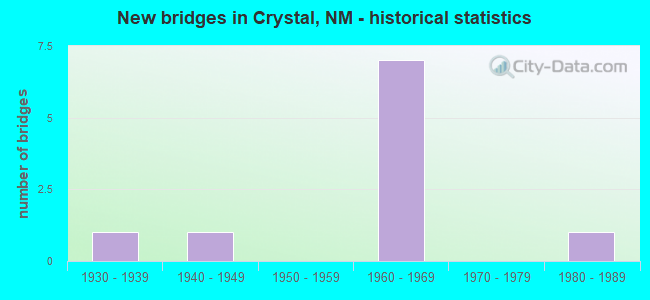
- New bridges - historical statistics
- 11930-1939
- 11940-1949
- 71960-1969
- 11980-1989


- Bridge Condition - Deck
- 20.0%Good
- 40.0%Satisfactory
- 30.0%Fair
- 10.0%Serious

- Bridge Condition - Superstructure
- 20.0%Good
- 40.0%Satisfactory
- 20.0%Fair
- 10.0%Serious
- 10.0%Critical

- Bridge Condition - Substructure
- 10.0%Good
- 30.0%Satisfactory
- 30.0%Fair
- 10.0%Poor
- 10.0%Serious
- 10.0%Critical

- Bridge Condition - Channel
- 40.0%Good
- 20.0%Satisfactory
- 40.0%Fair
Find on map >> Show street view
Structure Number: 749, Location: .01MN Jct IndianSchool Rd (Lat: 35.101322, Lng: -106.506422), Route carried "on" structure: City street 5015, Year Built: 1964, Status: Open, Structure Length: 1.62m (5.31ft), Average Daily Traffic: 3,128 (year 2020), Truck Traffic: 6%, Average Future Daily Traffic: 5,098 (year 2040), Design Load: HS 20, Features Intersected: Embudo Arroyo
Minimum Vertical Clearance: 30+ m (98+ ft), Kilometerpoint: 2.414, Lanes on structure: 2, Owner: City or Municipal Highway Agency, Approaching Roadway Width: 14.7m (48.2ft), Material/Design: Concrete continuous, Design/Construction: Slab, Number Of Spans In Main Unit: 2, Length of Maximum Span: 7.6m (24.9ft), Curb or Sidewalk Widths: Left: 1.5m (4.9ft), Right: 1.5m (4.9ft), Curb-To-Curb Width: 14.6m (47.9ft), Out-to-Out Width: 17.5m (57.4ft)
Condition: Deck: Satisfactory, Superstructure: Satisfactory, Substructure: Good, Channel: Satisfactory, Operating Rating: 47.0 metric tons, Method Used To Determine Operating Rating: Load Factor (LF), Inventory Rating: 32.4 metric tons, Method Used To Determine Inventory Rating: Load Factor (LF), Structural Evaluation: Equal to present minimum criteria, Deck Geometry: Superior to present desirable criteria, Waterway Adequacy: Equal to present desirable criteria, Approach Roadway Alignment: Equal to present desirable criteria, Designated Inspection Frequency: Every 24 months, Inspection Date: November 2021, Deck Structure Type: Concrete Cast-file-Place, Wearing Surface/Protective System: Wearing Surface: Epoxy Overlay
Find on map >> Show street view
Structure Number: 7491, Location: 0.25 M S of Menual Blvd (Lat: 35.106308, Lng: -106.595633), Route carried "on" structure: City street 5083, Year Built: 1969, Status: Open, Structure Length: 1.92m (6.30ft), Average Daily Traffic: 6,245 (year 2020), Truck Traffic: 6%, Average Future Daily Traffic: 10,177 (year 2040), Design Load: HS 20, Features Intersected: Embudo Arroyo
Minimum Vertical Clearance: 30+ m (98+ ft), Kilometerpoint: 3.489, Lanes on structure: 2, Owner: City or Municipal Highway Agency, Approaching Roadway Width: 14.6m (47.9ft), Material/Design: Prestressed concrete, Design/Construction: Stringer/Multi-beam, Number Of Spans In Main Unit: 1, Length of Maximum Span: 18.3m (60.0ft), Curb or Sidewalk Widths: Left: 1.3m (4.3ft), Right: 1.3m (4.3ft), Curb-To-Curb Width: 14.6m (47.9ft), Out-to-Out Width: 17.2m (56.4ft)
Condition: Deck: Fair, Superstructure: Satisfactory, Substructure: Fair, Channel: Good, Operating Rating: 53.5 metric tons, Method Used To Determine Operating Rating: Load Factor (LF), Inventory Rating: 32.4 metric tons, Method Used To Determine Inventory Rating: Load Factor (LF), Structural Evaluation: Somewhat better than minimum adequacy, Deck Geometry: Superior to present desirable criteria, Waterway Adequacy: Superior to present desirable criteria, Approach Roadway Alignment: Equal to present desirable criteria, Length Of Structure Improvement: 1.92m (6.30ft), Designated Inspection Frequency: Every 24 months, Inspection Date: April 2021, Bridge Improvement Cost: $159,000, Roadway Improvement Cost: $15,000, Total Project Cost: $239,000 ( Estimate for 2030), Deck Structure Type: Concrete Cast-file-Place, Wearing Surface/Protective System: Wearing Surface: Epoxy Overlay
Find on map >> Show street view
Structure Number: 7492, Location: 0.3 Mi S Montgomery Blvd (Lat: 35.127125, Lng: -106.595297), Route carried "on" structure: City street 5127, Year Built: 1966, Status: Open, Structure Length: 1.77m (5.81ft), Average Daily Traffic: 267 (year 2020), Average Future Daily Traffic: 487 (year 2040), Design Load: HS 20, Features Intersected: Hahn Arroyo
Minimum Vertical Clearance: 30+ m (98+ ft), Kilometerpoint: 0.016, Lanes on structure: 2, Owner: City or Municipal Highway Agency, Approaching Roadway Width: 12.3m (40.4ft), Material/Design: Concrete continuous, Design/Construction: Slab, Number Of Spans In Main Unit: 2, Length of Maximum Span: 8.5m (27.9ft), Curb or Sidewalk Widths: Left: 1.5m (4.9ft), Right: 1.5m (4.9ft), Curb-To-Curb Width: 12.2m (40.0ft), Out-to-Out Width: 15.2m (49.9ft)
Condition: Deck: Fair, Superstructure: Fair, Substructure: Fair, Channel: Fair, Operating Rating: 59.9 metric tons, Method Used To Determine Operating Rating: Load Factor (LF), Inventory Rating: 32.4 metric tons, Method Used To Determine Inventory Rating: Load Factor (LF), Structural Evaluation: Somewhat better than minimum adequacy, Deck Geometry: Superior to present desirable criteria, Waterway Adequacy: Equal to present desirable criteria, Approach Roadway Alignment: Equal to present desirable criteria, Designated Inspection Frequency: Every 24 months, Inspection Date: April 2021, Deck Structure Type: Concrete Cast-file-Place, Wearing Surface/Protective System: Deck Protection: Epoxy Coated Reinforcing
Find on map >> Show street view
Structure Number: 7493, Location: 0.2 Mi S Montgomery Blvd (Lat: 35.127694, Lng: -106.604022), Route carried "on" structure: City street 5014, Year Built: 1968, Status: Open, Structure Length: 1.65m (5.41ft), Average Daily Traffic: 17,546 (year 2020), Truck Traffic: 7%, Average Future Daily Traffic: 19,654 (year 2040), Design Load: HS 20, Features Intersected: Hahn Arroyo
Minimum Vertical Clearance: 30+ m (98+ ft), Kilometerpoint: 7.776, Lanes on structure: 3, Owner: City or Municipal Highway Agency, Approaching Roadway Width: 10.4m (34.1ft), Skew: 10 degrees, Material/Design: Prestressed concrete, Design/Construction: Stringer/Multi-beam, Number Of Spans In Main Unit: 1, Length of Maximum Span: 15.5m (50.9ft), Curb or Sidewalk Widths: Left: 1.5m (4.9ft), Right: 1.5m (4.9ft), Curb-To-Curb Width: 10.4m (34.1ft), Out-to-Out Width: 13.6m (44.6ft)
Condition: Deck: Satisfactory, Superstructure: Good, Substructure: Fair, Channel: Good, Operating Rating: 53.5 metric tons, Method Used To Determine Operating Rating: Load Factor (LF), Inventory Rating: 32.4 metric tons, Method Used To Determine Inventory Rating: Load Factor (LF), Structural Evaluation: Somewhat better than minimum adequacy, Deck Geometry: High priority of replacement, Waterway Adequacy: Equal to present desirable criteria, Approach Roadway Alignment: Equal to present desirable criteria, Designated Inspection Frequency: Every 24 months, Inspection Date: April 2021, Deck Structure Type: Concrete Cast-file-Place, Wearing Surface/Protective System: Wearing Surface: Epoxy Overlay, Deck Protection: Epoxy Coated Reinforcing
Find on map >> Show street view
Structure Number: 7494, Location: 0.26 Mi S Montgomery Blvd (Lat: 35.127686, Lng: -106.604183), Route carried "on" structure: City street 5014, Year Built: 1968, Status: Open, Structure Length: 1.65m (5.41ft), Average Daily Traffic: 17,546 (year 2020), Truck Traffic: 7%, Average Future Daily Traffic: 19,654 (year 2040), Design Load: HS 20, Features Intersected: Hahn Arroyo
Minimum Vertical Clearance: 30+ m (98+ ft), Kilometerpoint: 0.000, Lanes on structure: 3, Owner: City or Municipal Highway Agency, Approaching Roadway Width: 10.4m (34.1ft), Skew: 10 degrees, Material/Design: Prestressed concrete, Design/Construction: Stringer/Multi-beam, Number Of Spans In Main Unit: 1, Length of Maximum Span: 15.5m (50.9ft), Curb or Sidewalk Widths: Left: 1.5m (4.9ft), Right: 1.5m (4.9ft), Curb-To-Curb Width: 10.4m (34.1ft), Out-to-Out Width: 13.7m (44.9ft)
Condition: Deck: Satisfactory, Superstructure: Satisfactory, Substructure: Satisfactory, Channel: Fair, Operating Rating: 53.5 metric tons, Method Used To Determine Operating Rating: Load Factor (LF), Inventory Rating: 32.4 metric tons, Method Used To Determine Inventory Rating: Load Factor (LF), Structural Evaluation: Equal to present minimum criteria, Deck Geometry: High priority of replacement, Waterway Adequacy: Equal to present desirable criteria, Approach Roadway Alignment: Equal to present desirable criteria, Length Of Structure Improvement: 6.10m (20.01ft), Designated Inspection Frequency: Every 24 months, Inspection Date: April 2021, Bridge Improvement Cost: $200,000, Roadway Improvement Cost: $25,000, Total Project Cost: $300,000 ( Estimate for 2030), Deck Structure Type: Concrete Cast-file-Place, Wearing Surface/Protective System: Wearing Surface: Epoxy Overlay, Deck Protection: Epoxy Coated Reinforcing
Find on map >> Show street view
Structure Number: 7495, Location: 1.1 M W of I-25 / Albuq (Lat: 35.153414, Lng: -106.605169), Route carried "on" structure: City street 4052, Year Built: 1966, Year Reconstructed: 1989, Status: Open, Structure Length: 3.08m (10.10ft), Average Daily Traffic: 19,066 (year 2020), Truck Traffic: 7%, Average Future Daily Traffic: 30,471 (year 2040), Design Load: HS 20, Features Intersected: North Diversion Channel
Minimum Vertical Clearance: 30+ m (98+ ft), Kilometerpoint: 3.093, Lanes on structure: 2, Base Highway Network: Yes, Owner: City or Municipal Highway Agency, Approaching Roadway Width: 11.0m (36.1ft), Skew: 11 degrees, Material/Design: Prestressed concrete, Design/Construction: Stringer/Multi-beam, Number Of Spans In Main Unit: 1, Length of Maximum Span: 30.2m (99.1ft), Curb or Sidewalk Widths: Left: 1.2m (3.9ft), Right: 1.2m (3.9ft), Curb-To-Curb Width: 11.0m (36.1ft), Out-to-Out Width: 13.5m (44.3ft)
Condition: Deck: Good, Superstructure: Good, Substructure: Satisfactory, Channel: Good, Operating Rating: 45.7 metric tons, Method Used To Determine Operating Rating: Load Factor (LF), Inventory Rating: 27.8 metric tons, Method Used To Determine Inventory Rating: Load Factor (LF), Structural Evaluation: Equal to present minimum criteria, Deck Geometry: Equal to present minimum criteria, Waterway Adequacy: Equal to present desirable criteria, Approach Roadway Alignment: Equal to present desirable criteria, Designated Inspection Frequency: Every 24 months, Inspection Date: January 2022, Deck Structure Type: Concrete Cast-file-Place, Wearing Surface/Protective System: Wearing Surface: Latex Concrete, Deck Protection: Epoxy Coated Reinforcing
Find on map >> Show street view
Structure Number: N614, Location: 4MI NO.INTERSEC.N12 & N32 (Lat: 36.049278, Lng: -109.044417), Route carried "on" structure: Federal lands road N12, Year Built: 1965, Status: Open, Structure Length: 2.59m (8.50ft), Average Daily Traffic: 1,547 (year 2020), Truck Traffic: 5%, Average Future Daily Traffic: 1,810 (year 2040), Design Load: HS 20, Features Intersected: COYOTE WASH
Minimum Vertical Clearance: 30+ m (98+ ft), Kilometerpoint: 90.587, Lanes on structure: 2, Owner: Bureau of Indian Affairs, Approaching Roadway Width: 8.8m (28.9ft), Material/Design: Steel, Design/Construction: Stringer/Multi-beam, Number Of Spans In Main Unit: 2, Length of Maximum Span: 12.4m (40.7ft), Curb or Sidewalk Widths: Left: 0.6m (2.0ft), Right: 0.6m (2.0ft), Curb-To-Curb Width: 8.6m (28.2ft), Out-to-Out Width: 9.8m (32.2ft)
Condition: Deck: Satisfactory, Superstructure: Satisfactory, Substructure: Satisfactory, Channel: Satisfactory, Operating Rating: 44.5 metric tons, Method Used To Determine Operating Rating: Allowable Stress (AS), Inventory Rating: 32.6 metric tons, Method Used To Determine Inventory Rating: Allowable Stress (AS), Structural Evaluation: Equal to present minimum criteria, Deck Geometry: Somewhat better than minimum adequacy, Waterway Adequacy: Equal to present minimum criteria, Approach Roadway Alignment: Equal to present desirable criteria, Designated Inspection Frequency: Every 24 months, Inspection Date: January 2020, Deck Structure Type: Concrete Cast-file-Place, Wearing Surface/Protective System: Wearing Surface: Monolithic Concrete
Find on map >> Show street view
Structure Number: N616, Location: IN CRYSTAL NEW MEXICO (Lat: 36.043722, Lng: -108.967333), Route carried "on" structure: Federal lands road N321, Year Built: 1940, Status: Posted for load-capacity, Structure Length: 2.62m (8.60ft), Average Daily Traffic: 254 (year 2021), Truck Traffic: 5%, Average Future Daily Traffic: 297 (year 2040), Features Intersected: CRYSTAL CREEK
Minimum Vertical Clearance: 30+ m (98+ ft), Kilometerpoint: 7.080, Lanes on structure: 2, Owner: Bureau of Indian Affairs, Approaching Roadway Width: 6.8m (22.3ft), Material/Design: Wood or Timber, Design/Construction: Stringer/Multi-beam, Number Of Spans In Main Unit: 4, Length of Maximum Span: 6.5m (21.3ft), Curb-To-Curb Width: 5.4m (17.7ft), Out-to-Out Width: 5.5m (18.0ft)
Condition: Deck: Fair, Superstructure: Critical, Substructure: Critical, Channel: Fair, Operating Rating: 28.4 metric tons, Method Used To Determine Operating Rating: Allowable Stress (AS), Inventory Rating: 20.6 metric tons, Method Used To Determine Inventory Rating: Allowable Stress (AS), Structural Evaluation: High priority of replacement, Waterway Adequacy: Better than present minimum criteria, Approach Roadway Alignment: Meets minimum limits, Bridge Posting: Required (Relationship of Operating Rating to Maximum Legal Load: 0.1 - 9.9% below), Length Of Structure Improvement: 3.40m (11.15ft), Designated Inspection Frequency: Every 12 months, Inspection Date: November 2021, Bridge Improvement Cost: $425,000, Roadway Improvement Cost: $50,000, Total Project Cost: $550,000 ( Estimate for 2021), Deck Structure Type: Wood or Timber, Wearing Surface/Protective System: Wearing Surface: Bituminous
Find on map >> Show street view
Structure Number: N617, Location: 2.0 MI NW OF CRYSTAL N.M. (Lat: 36.060056, Lng: -108.995278), Route carried "on" structure: Federal lands road N321, Year Built: 1936, Status: Closed, Structure Length: 2.38m (7.81ft), Average Daily Traffic: 272 (year 2012), Truck Traffic: 5%, Average Future Daily Traffic: 272 (year 2032), Features Intersected: SAND SPRING CREEK
Minimum Vertical Clearance: 30+ m (98+ ft), Kilometerpoint: 11.263, Lanes on structure: 1, Owner: Bureau of Indian Affairs, Approaching Roadway Width: 4.3m (14.1ft), Material/Design: Wood or Timber, Design/Construction: Stringer/Multi-beam, Number Of Spans In Main Unit: 4, Length of Maximum Span: 5.9m (19.4ft), Curb-To-Curb Width: 4.1m (13.5ft), Out-to-Out Width: 4.3m (14.1ft)
Condition: Deck: Serious, Superstructure: Serious, Substructure: Serious, Channel: Good, Operating Rating: 19.4 metric tons, Method Used To Determine Operating Rating: Allowable Stress (AS), Inventory Rating: 13.7 metric tons, Method Used To Determine Inventory Rating: Allowable Stress (AS), Structural Evaluation: High priority of corrective action, Waterway Adequacy: Meets minimum limits, Approach Roadway Alignment: High priority of corrective action, Bridge Posting: Required (Relationship of Operating Rating to Maximum Legal Load: 20.0 - 29.9% below), Length Of Structure Improvement: 2.80m (9.19ft), Designated Inspection Frequency: Every 24 months, Inspection Date: January 2019, Bridge Improvement Cost: $552,000, Roadway Improvement Cost: $50,000, Total Project Cost: $602,000 ( Estimate for 2014), Deck Structure Type: Wood or Timber
Find on map >> Show street view
Structure Number: N667, Location: 1 MI EAST OF CRYSTAL NM (Lat: 36.053667, Lng: -108.961694), Route carried "on" structure: Federal lands road N9603, Year Built: 1989, Status: Posted for load-capacity, Structure Length: 1.91m (6.27ft), Average Daily Traffic: 20 (year 2021), Average Future Daily Traffic: 30 (year 2039), Features Intersected: CRYSTAL CREEK
Minimum Vertical Clearance: 30+ m (98+ ft), Kilometerpoint: 1.126, Lanes on structure: 1, Owner: Bureau of Indian Affairs, Approaching Roadway Width: 5.8m (19.0ft), Material/Design: Steel, Design/Construction: Truss - Thru, Number Of Spans In Main Unit: 1, Length of Maximum Span: 18.2m (59.7ft), Curb or Sidewalk Widths: Left: 0.2m (0.7ft), Right: 0.2m (0.7ft), Curb-To-Curb Width: 4.0m (13.1ft), Out-to-Out Width: 4.3m (14.1ft)
Condition: Deck: Good, Superstructure: Fair, Substructure: Poor, Channel: Fair, Operating Rating: 22.9 metric tons, Method Used To Determine Operating Rating: Load Factor (LF), Inventory Rating: 13.7 metric tons, Method Used To Determine Inventory Rating: Load Factor (LF), Structural Evaluation: Meets minimum limits, Deck Geometry: Somewhat better than minimum adequacy, Waterway Adequacy: Equal to present minimum criteria, Approach Roadway Alignment: Somewhat better than minimum adequacy, Bridge Posting: Required (Relationship of Operating Rating to Maximum Legal Load: > 39.9% below), Length Of Structure Improvement: 2.50m (8.20ft), Designated Inspection Frequency: Every 12 months, Critical Feature Inspection Frequency: Every 12 months, Inspection Date: November 2021, Critical Feature Inspection Date: November 2021, Bridge Improvement Cost: $340,000, Roadway Improvement Cost: $40,000, Total Project Cost: $445,000 ( Estimate for 2021), Deck Structure Type: Wood or Timber, Wearing Surface/Protective System: Wearing Surface: Wood or Timber