Bridge Statistics for Crockett, California (CA)
Condition, Traffic, Stress, Structural Evaluation, Project Costs
- National Bridge Inventory (NBI) Statistics
- 11Number of bridges
- 866ft / 264mTotal length
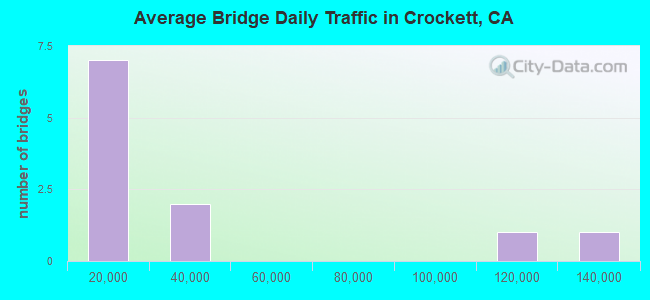
- 312,003Total average daily traffic
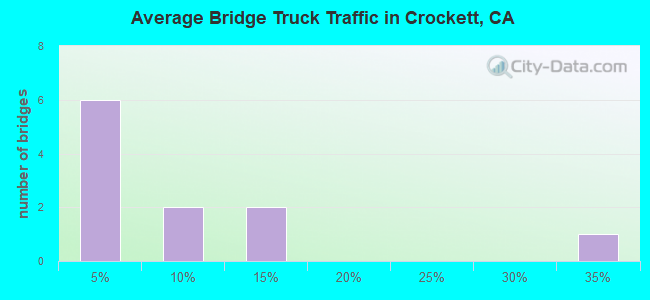
- 23,726Total average daily truck traffic
- National Bridge Inventory (NBI) Registered Bridges for Crockett
- No street view available for this location
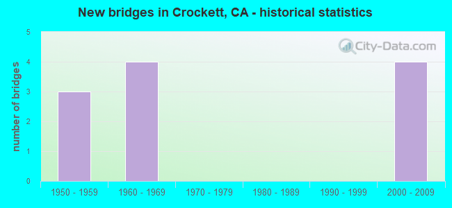
- New bridges - historical statistics
- 31950-1959
- 41960-1969
- 42000-2009
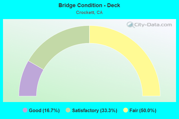
- Bridge Condition - Deck
- 16.7%Good
- 33.3%Satisfactory
- 50.0%Fair
Find on map >> Show street view
Structure Number: 23 0015R, Location: 04-SOL-080-0.01 (Lat: 38.054722, Lng: -122.224908), Route carried "on" structure: Interstate 80, Year Built: 1958, Status: Open, Structure Length: 158.77m (520.90ft), Average Daily Traffic: 128,000 (year 2019), Truck Traffic: 6%, Average Future Daily Traffic: 192,000 (year 2040), Design Load: HS 20, Features Intersected: CARQUINEZ STRAIT,UP RR
Minimum Vertical Clearance: 6.25m (20.51ft), Kilometerpoint: 0.010, Lanes on structure: 4, Lanes under structure: 14, Base Highway Network: Yes (, Subroute: 1), Toll: Toll bridge, Owner: State Highway Agency, Approaching Roadway Width: 15.8m (51.8ft), Navigation Control: Yes ( Vertical Clearance: 39.9m (130.9ft), Horizontal Clearance: 304.2m (998.0ft)), Material/Design: Steel continuous, Design/Construction: Truss - Thru, Number Of Spans In Main Unit: 5, Number Of Approach Spans: 18, Length of Maximum Span: 335.3m (1,100.1ft), Curb or Sidewalk Widths: Left: 0.5m (1.6ft), Right: 0.5m (1.6ft), Curb-To-Curb Width: 15.8m (51.8ft), Out-to-Out Width: 17.6m (57.7ft)
Condition: Deck: Fair, Superstructure: Good, Substructure: Good, Channel: Satisfactory, Operating Rating: 42.1 metric tons, Method Used To Determine Operating Rating: Load Factor (LF), Inventory Rating: 25.3 metric tons, Method Used To Determine Inventory Rating: Load Factor (LF), Structural Evaluation: Equal to present minimum criteria, Deck Geometry: Meets minimum limits, Underclear: High priority of corrective action, Waterway Adequacy: Equal to present desirable criteria, Approach Roadway Alignment: Equal to present desirable criteria, Designated Inspection Frequency: Every 24 months, Critical Feature Inspection Frequency: Every 24 months, Underwater Inspection Frequency: Every 60 months, Inspection Date: September 2021, Critical Feature Inspection Date: August 2020, Underwater Inspection Date: April 2018, Deck Structure Type: Concrete Cast-file-Place, Wearing Surface/Protective System: Wearing Surface: Integral Concrete
Find on map >> Show street view
Structure Number: 28 0149, Location: 04-CC-080-12.75 (Lat: 38.045175, Lng: -122.238644), Route carried "on" structure: County highway , Year Built: 1958, Status: Open, Structure Length: 8.79m (28.84ft), Average Daily Traffic: 8,200 (year 2019), Truck Traffic: 1%, Average Future Daily Traffic: 21,377 (year 2041), Design Load: HS 20, Features Intersected: INTERSTATE 80, Facility Carried by Structure: CUMMINGS SKYWAY
Minimum Vertical Clearance: 30+ m (98+ ft), Kilometerpoint: 0.000, Lanes on structure: 2, Lanes under structure: 6, Base Highway Network: Yes, Owner: State Highway Agency, Approaching Roadway Width: 8.5m (27.9ft), Skew: 4 degrees, Material/Design: Steel, Design/Construction: Stringer/Multi-beam, Number Of Spans In Main Unit: 4, Length of Maximum Span: 26.5m (86.9ft), Curb or Sidewalk Widths: Left: 1.6m (5.2ft), Right: 0.6m (2.0ft), Curb-To-Curb Width: 8.5m (27.9ft), Out-to-Out Width: 11.3m (37.1ft)
Condition: Deck: Fair, Superstructure: Good, Substructure: Good, Operating Rating: 41.1 metric tons, Method Used To Determine Operating Rating: Load and Resistance Factor Rating (LRFR) rating reported by rating factor(RF) method using HL-93 loadings, Inventory Rating: 31.8 metric tons, Method Used To Determine Inventory Rating: Load and Resistance Factor Rating (LRFR) rating reported by rating factor(RF) method using HL-93 loadings, Structural Evaluation: Better than present minimum criteria, Deck Geometry: Meets minimum limits, Underclear: Meets minimum limits, Approach Roadway Alignment: Somewhat better than minimum adequacy, Designated Inspection Frequency: Every 24 months, Inspection Date: July 2021, Deck Structure Type: Concrete Cast-file-Place
Find on map >> Show street view
Structure Number: 28 0215L, Location: 04-CC-004-R5.17 (Lat: 38.015144, Lng: -122.177878), Route carried "on" structure: State highway 4, Year Built: 1967, Status: Open, Structure Length: 4.48m (14.70ft), Average Daily Traffic: 23,000 (year 2018), Truck Traffic: 12%, Average Future Daily Traffic: 48,517 (year 2042), Design Load: H 20, Features Intersected: MCEWEN ROAD
Minimum Vertical Clearance: 30+ m (98+ ft), Kilometerpoint: 5.170, Lanes on structure: 2, Lanes under structure: 2, Base Highway Network: Yes (, Subroute: 1), Owner: State Highway Agency, Approaching Roadway Width: 11.3m (37.1ft), Skew: 1 degrees, Material/Design: Concrete continuous, Design/Construction: Tee Beam, Number Of Spans In Main Unit: 3, Length of Maximum Span: 19.8m (65.0ft), Curb-To-Curb Width: 11.0m (36.1ft), Out-to-Out Width: 11.6m (38.1ft)
Condition: Deck: Satisfactory, Superstructure: Good, Substructure: Good, Operating Rating: 38.2 metric tons, Method Used To Determine Operating Rating: Load and Resistance Factor Rating (LRFR) rating reported by rating factor(RF) method using HL-93 loadings, Inventory Rating: 29.5 metric tons, Method Used To Determine Inventory Rating: Load and Resistance Factor Rating (LRFR) rating reported by rating factor(RF) method using HL-93 loadings, Structural Evaluation: Better than present minimum criteria, Deck Geometry: Somewhat better than minimum adequacy, Underclear: Equal to present minimum criteria, Approach Roadway Alignment: Equal to present desirable criteria, Designated Inspection Frequency: Every 24 months, Inspection Date: May 2020, Deck Structure Type: Concrete Cast-file-Place
Find on map >> Show street view
Structure Number: 28 0215R, Location: 04-CC-004-R5.17 (Lat: 38.014936, Lng: -122.177944), Route carried "on" structure: State highway 4, Year Built: 1967, Status: Open, Structure Length: 4.48m (14.70ft), Average Daily Traffic: 23,000 (year 2018), Truck Traffic: 12%, Average Future Daily Traffic: 48,517 (year 2042), Design Load: HS 20, Features Intersected: MCEWEN ROAD
Minimum Vertical Clearance: 30+ m (98+ ft), Kilometerpoint: 5.170, Lanes on structure: 2, Lanes under structure: 2, Base Highway Network: Yes (, Subroute: 1), Owner: State Highway Agency, Approaching Roadway Width: 11.3m (37.1ft), Skew: 1 degrees, Material/Design: Concrete continuous, Design/Construction: Tee Beam, Number Of Spans In Main Unit: 3, Length of Maximum Span: 19.8m (65.0ft), Curb-To-Curb Width: 11.4m (37.4ft), Out-to-Out Width: 12.0m (39.4ft)
Condition: Deck: Satisfactory, Superstructure: Good, Substructure: Good, Operating Rating: 38.2 metric tons, Method Used To Determine Operating Rating: Load and Resistance Factor Rating (LRFR) rating reported by rating factor(RF) method using HL-93 loadings, Inventory Rating: 29.5 metric tons, Method Used To Determine Inventory Rating: Load and Resistance Factor Rating (LRFR) rating reported by rating factor(RF) method using HL-93 loadings, Structural Evaluation: Better than present minimum criteria, Deck Geometry: Somewhat better than minimum adequacy, Underclear: Equal to present minimum criteria, Approach Roadway Alignment: Equal to present desirable criteria, Length Of Structure Improvement: 4.48m (14.70ft), Designated Inspection Frequency: Every 24 months, Inspection Date: May 2020, Deck Structure Type: Concrete Cast-file-Place
Find on map >> Show street view
Structure Number: 28 0368K, Location: 04-CC-080-13.48 (Lat: 38.052678, Lng: -122.228322), Route carried "on" structure: Ramp Interstate 80, Year Built: 2003, Status: Open, Structure Length: 35.66m (116.99ft), Average Daily Traffic: 3,100 (year 2012), Truck Traffic: 3%, Average Future Daily Traffic: 5,101 (year 2041), Design Load: HS 20+Mod, Features Intersected: WANDA, POMONA, VIRGINIA
Minimum Vertical Clearance: 30+ m (98+ ft), Kilometerpoint: 13.480, Lanes on structure: 1, Lanes under structure: 8, Owner: State Highway Agency, Approaching Roadway Width: 6.6m (21.7ft), Material/Design: Prestressed concrete continuous, Design/Construction: Box Beam or Girders - Multiple, Number Of Spans In Main Unit: 8, Length of Maximum Span: 51.2m (168.0ft), Curb-To-Curb Width: 6.6m (21.7ft), Out-to-Out Width: 8.3m (27.2ft)
Condition: Deck: Fair, Superstructure: Good, Substructure: Good, Operating Rating: 54.1 metric tons, Method Used To Determine Operating Rating: Assigned rating based on Load Factor Design (LFD) reported in metric tons, Inventory Rating: 32.4 metric tons, Method Used To Determine Inventory Rating: Assigned rating based on Load Factor Design (LFD) reported in metric tons, Structural Evaluation: Better than present minimum criteria, Deck Geometry: Somewhat better than minimum adequacy, Approach Roadway Alignment: Equal to present desirable criteria, Designated Inspection Frequency: Every 24 months, Inspection Date: December 2021, Deck Structure Type: Concrete Cast-file-Place, Wearing Surface/Protective System: Wearing Surface: Integral Concrete
Find on map >> Show street view
Structure Number: 28 0369S, Location: 04-CC-080-13.48 (Lat: 38.052036, Lng: -122.227917), Route carried "on" structure: Ramp Interstate 80, Year Built: 2003, Status: Open, Structure Length: 51.89m (170.24ft), Average Daily Traffic: 2,700 (year 2012), Truck Traffic: 3%, Average Future Daily Traffic: 5,101 (year 2041), Design Load: HS 20+Mod, Features Intersected: POMONA ST, WANDA ST
Minimum Vertical Clearance: 5.55m (18.21ft), Kilometerpoint: 13.480, Lanes on structure: 1, Lanes under structure: 3, Owner: State Highway Agency, Approaching Roadway Width: 7.3m (24.0ft), Skew: 9 degrees, Material/Design: Prestressed concrete continuous, Design/Construction: Box Beam or Girders - Multiple, Number Of Spans In Main Unit: 11, Number Of Approach Spans: 1, Length of Maximum Span: 50.0m (164.0ft), Curb-To-Curb Width: 7.3m (24.0ft), Out-to-Out Width: 8.3m (27.2ft)
Condition: Deck: Good, Superstructure: Good, Substructure: Good, Operating Rating: 54.1 metric tons, Method Used To Determine Operating Rating: Assigned rating based on Load Factor Design (LFD) reported in metric tons, Inventory Rating: 32.4 metric tons, Method Used To Determine Inventory Rating: Assigned rating based on Load Factor Design (LFD) reported in metric tons, Structural Evaluation: Better than present minimum criteria, Deck Geometry: Better than present minimum criteria, Approach Roadway Alignment: Equal to present desirable criteria, Designated Inspection Frequency: Every 24 months, Inspection Date: December 2021, Deck Structure Type: Concrete Cast-file-Place, Wearing Surface/Protective System: Wearing Surface: Integral Concrete
Find on map >> Show street view
Structure Number: 28 0149, Location: 04-CC-080-12.75 (Lat: 38.045175, Lng: -122.238644), Route carried "under" structure: Interstate 80, Year Built: 1958, Structure Length: 0. m, Average Daily Traffic: 115,000 (year 2019), Truck Traffic: 7%, Features Intersected: INTERSTATE 80, Facility Carried by Structure: CUMMINGS SKYWAY
Minimum Vertical Clearance: 5.92m (19.42ft), Kilometerpoint: 12.750, Lanes on structure: 2, Lanes under structure: 6, Material/Design: Steel, Design/Construction: Stringer/Multi-beam, Length of Maximum Span: 26.5m (86.9ft)
Find on map >> Show street view
Structure Number: 28 0215L, Location: 04-CC-004-R5.17 (Lat: 38.015144, Lng: -122.177878), Route carried "under" structure: County highway , Year Built: 1967, Structure Length: 0. m, Average Daily Traffic: 75 (year 2018), Truck Traffic: 1%, Features Intersected: MCEWEN ROAD, Facility Carried by Structure: STATE ROUTE 4 WB
Minimum Vertical Clearance: 5.97m (19.59ft), Kilometerpoint: 0.000, Lanes on structure: 2, Lanes under structure: 2, Material/Design: Concrete continuous, Design/Construction: Tee Beam, Length of Maximum Span: 19.8m (65.0ft)
Find on map >> Show street view
Structure Number: 28 0215R, Location: 04-CC-004-R5.17 (Lat: 38.014936, Lng: -122.177944), Route carried "under" structure: County highway , Year Built: 1967, Structure Length: 0. m, Average Daily Traffic: 75 (year 2018), Truck Traffic: 1%, Features Intersected: MCEWEN ROAD, Facility Carried by Structure: STATE ROUTE 4 EB
Minimum Vertical Clearance: 4.64m (15.22ft), Kilometerpoint: 0.000, Lanes on structure: 2, Lanes under structure: 2, Material/Design: Concrete continuous, Design/Construction: Tee Beam, Length of Maximum Span: 19.8m (65.0ft)
Find on map >> Show street view
Structure Number: 28 0368K, Location: 04-CC-080-13.48 (Lat: 38.052678, Lng: -122.228322), Route carried "under" structure: City street , Year Built: 2003, Structure Length: 0. m, Average Daily Traffic: 7,353 (year 2013), Truck Traffic: 30%, Features Intersected: WANDA, POMONA, VIRGINIA, Facility Carried by Structure: POMONA ST-WB 80 ON
Minimum Vertical Clearance: 9.10m (29.86ft), Kilometerpoint: 0.000, Lanes on structure: 1, Lanes under structure: 2, Material/Design: Prestressed concrete continuous, Design/Construction: Box Beam or Girders - Multiple, Length of Maximum Span: 51.2m (168.0ft)
Find on map >> Show street view
Structure Number: 28 0369S, Location: 04-CC-080-13.48 (Lat: 38.052036, Lng: -122.227917), Route carried "under" structure: City street , Year Built: 2003, Structure Length: 0. m, Average Daily Traffic: 1,500 (year 2013), Truck Traffic: 1%, Features Intersected: POMONA ST, WANDA ST, Facility Carried by Structure: EB80-POMONA ST OFF
Minimum Vertical Clearance: 9.60m (31.50ft), Kilometerpoint: 0.000, Lanes on structure: 1, Lanes under structure: 1, Material/Design: Prestressed concrete continuous, Design/Construction: Box Beam or Girders - Multiple, Length of Maximum Span: 50.0m (164.0ft)