Bridge Statistics for Coulterville, Illinois (IL)
Condition, Traffic, Stress, Structural Evaluation, Project Costs
- National Bridge Inventory (NBI) Statistics
- 12Number of bridges
- 62ft / 18.8mTotal length
- $36,000Total costs
- 5,910Total average daily traffic
- 649Total average daily truck traffic
- 6,561Total future (year 2032) average daily traffic
- National Bridge Inventory (NBI) Registered Bridges for Coulterville
- No street view available for this location
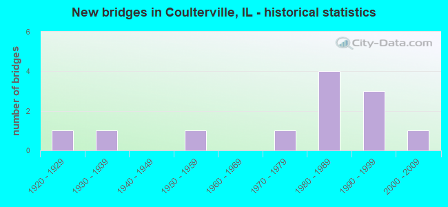
- New bridges - historical statistics
- 11920-1929
- 11930-1939
- 11950-1959
- 11970-1979
- 41980-1989
- 31990-1999
- 12000-2009

- Reconstructed bridges - Historical Statistics
- 11960-1969
- 01970-1979
- 01980-1989
- 11990-1999

- Bridge Condition - Deck
- 30.0%Very good
- 50.0%Good
- 20.0%Fair

- Bridge Condition - Superstructure
- 30.0%Very good
- 50.0%Good
- 20.0%Fair

- Bridge Condition - Substructure
- 60.0%Very good
- 20.0%Satisfactory
- 10.0%Fair
- 10.0%Poor

- Bridge Condition - Channel
- 8.3%Very good
- 58.3%Good
- 33.3%Satisfactory
Find on map >> Show street view
Structure Number: 732005, Location: 1 MI E RANDOLPH CO (Lat: 38.177042, Lng: -89.575611), Route carried "on" structure: State highway 13, Year Built: 2001, Status: Open, Structure Length: 0.94m (3.08ft), Average Daily Traffic: 2,200 (year 2021), Truck Traffic: 6%, Average Future Daily Traffic: 2,266 (year 2032), Design Load: HS 20, Features Intersected: GALUM CREEK
Minimum Vertical Clearance: 30+ m (98+ ft), Kilometerpoint: 72.000, Lanes on structure: 2, Base Highway Network: Yes, Owner: State Highway Agency, Approaching Roadway Width: 7.9m (25.9ft), Skew: 4 degrees, Material/Design: Concrete, Design/Construction: Culvert, Number Of Spans In Main Unit: 2, Length of Maximum Span: 4.1m (13.5ft)
Condition: Channel: Satisfactory, Culverts: Good, Operating Rating: 61.9 metric tons, Method Used To Determine Operating Rating: Load Factor (LF) rating reported by rating factor (RF) method using MS18 loading, Inventory Rating: 37.3 metric tons, Method Used To Determine Inventory Rating: Load Factor (LF) rating reported by rating factor (RF) method using MS18 loading, Structural Evaluation: Better than present minimum criteria, Waterway Adequacy: Superior to present desirable criteria, Approach Roadway Alignment: Equal to present desirable criteria, Designated Inspection Frequency: Every 48 months, Inspection Date: January 2019
Find on map >> Show street view
Structure Number: 733106, Location: 0.5 MI S OF ILL 13 (Lat: 38.168411, Lng: -89.574347), Route carried "on" structure: County highway , Year Built: 1978, Status: Open, Structure Length: 1.46m (4.79ft), Average Daily Traffic: 100 (year 2019), Truck Traffic: 8%, Average Future Daily Traffic: 77 (year 2032), Design Load: HS 20, Features Intersected: GALUM CREEK, Facility Carried by Structure: TR 55
Minimum Vertical Clearance: 30+ m (98+ ft), Kilometerpoint: 1.593, Lanes on structure: 2, Owner: Town or Township Highway Agency, Approaching Roadway Width: 6.1m (20.0ft), Skew: 3 degrees, Material/Design: Prestressed concrete, Design/Construction: Box Beam or Girders - Multiple, Number Of Spans In Main Unit: 1, Length of Maximum Span: 13.7m (44.9ft), Curb-To-Curb Width: 6.3m (20.7ft), Out-to-Out Width: 6.4m (21.0ft)
Condition: Deck: Good, Superstructure: Good, Substructure: Satisfactory, Channel: Satisfactory, Operating Rating: 44.4 metric tons, Method Used To Determine Operating Rating: Assigned rating based on Load Factor Design (LFD) reported by rating factor (RF) using MS18 loading, Inventory Rating: 32.4 metric tons, Method Used To Determine Inventory Rating: Assigned rating based on Load Factor Design (LFD) reported by rating factor (RF) using MS18 loading, Structural Evaluation: Equal to present minimum criteria, Deck Geometry: Somewhat better than minimum adequacy, Waterway Adequacy: Equal to present minimum criteria, Approach Roadway Alignment: Somewhat better than minimum adequacy, Designated Inspection Frequency: Every 24 months, Inspection Date: January 2021, Deck Structure Type: Concrete Precast Panels, Wearing Surface/Protective System: Wearing Surface: Bituminous
Find on map >> Show street view
Structure Number: 733119, Location: 1.4 MI E FAS 1834 (Lat: 38.146392, Lng: -89.569364), Route carried "on" structure: County highway , Year Built: 1981, Status: Open, Structure Length: 1.28m (4.20ft), Average Daily Traffic: 75 (year 2019), Truck Traffic: 8%, Average Future Daily Traffic: 52 (year 2032), Design Load: HS 20, Features Intersected: GALUM CREEK, Facility Carried by Structure: TR 81
Minimum Vertical Clearance: 30+ m (98+ ft), Kilometerpoint: 2.317, Lanes on structure: 2, Owner: Town or Township Highway Agency, Approaching Roadway Width: 6.7m (22.0ft), Material/Design: Prestressed concrete, Design/Construction: Box Beam or Girders - Multiple, Number Of Spans In Main Unit: 1, Length of Maximum Span: 12.5m (41.0ft), Curb-To-Curb Width: 7.4m (24.3ft), Out-to-Out Width: 7.4m (24.3ft)
Condition: Deck: Good, Superstructure: Good, Substructure: Very good, Channel: Good, Operating Rating: 44.4 metric tons, Method Used To Determine Operating Rating: Assigned rating based on Load Factor Design (LFD) reported by rating factor (RF) using MS18 loading, Inventory Rating: 32.4 metric tons, Method Used To Determine Inventory Rating: Assigned rating based on Load Factor Design (LFD) reported by rating factor (RF) using MS18 loading, Structural Evaluation: Better than present minimum criteria, Deck Geometry: Equal to present minimum criteria, Waterway Adequacy: Equal to present desirable criteria, Approach Roadway Alignment: Equal to present desirable criteria, Designated Inspection Frequency: Every 48 months, Inspection Date: January 2019, Deck Structure Type: Concrete Precast Panels, Wearing Surface/Protective System: Wearing Surface: Gravel
Find on map >> Show street view
Structure Number: 733131, Location: 0.8 MI E OF CH 12 (Lat: 38.131867, Lng: -89.577492), Route carried "on" structure: County highway , Year Built: 1983, Status: Open, Structure Length: 1.77m (5.81ft), Average Daily Traffic: 75 (year 2019), Truck Traffic: 13%, Average Future Daily Traffic: 103 (year 2032), Design Load: HS 20, Features Intersected: GALUM CREEK, Facility Carried by Structure: TR 91
Minimum Vertical Clearance: 30+ m (98+ ft), Kilometerpoint: 1.320, Lanes on structure: 2, Owner: Town or Township Highway Agency, Approaching Roadway Width: 6.7m (22.0ft), Material/Design: Prestressed concrete, Design/Construction: Box Beam or Girders - Multiple, Number Of Spans In Main Unit: 1, Length of Maximum Span: 17.1m (56.1ft), Curb-To-Curb Width: 7.4m (24.3ft), Out-to-Out Width: 7.4m (24.3ft)
Condition: Deck: Good, Superstructure: Good, Substructure: Very good, Channel: Good, Operating Rating: 44.4 metric tons, Method Used To Determine Operating Rating: Assigned rating based on Load Factor Design (LFD) reported by rating factor (RF) using MS18 loading, Inventory Rating: 32.4 metric tons, Method Used To Determine Inventory Rating: Assigned rating based on Load Factor Design (LFD) reported by rating factor (RF) using MS18 loading, Structural Evaluation: Better than present minimum criteria, Deck Geometry: Equal to present minimum criteria, Waterway Adequacy: Equal to present desirable criteria, Approach Roadway Alignment: Equal to present desirable criteria, Designated Inspection Frequency: Every 48 months, Inspection Date: January 2019, Deck Structure Type: Concrete Precast Panels, Wearing Surface/Protective System: Wearing Surface: Gravel
Find on map >> Show street view
Structure Number: 733148, Location: 2 MI SW OF SWANWICK (Lat: 38.161108, Lng: -89.576133), Route carried "on" structure: County highway , Year Built: 1988, Status: Open, Structure Length: 1.67m (5.48ft), Average Daily Traffic: 10 (year 2019), Average Future Daily Traffic: 26 (year 2032), Design Load: HS 20, Features Intersected: GALUM CREEK, Facility Carried by Structure: TR 63
Minimum Vertical Clearance: 30+ m (98+ ft), Kilometerpoint: 0.193, Lanes on structure: 2, Owner: Town or Township Highway Agency, Approaching Roadway Width: 6.7m (22.0ft), Skew: 3 degrees, Material/Design: Prestressed concrete, Design/Construction: Box Beam or Girders - Multiple, Number Of Spans In Main Unit: 1, Length of Maximum Span: 15.8m (51.8ft), Curb-To-Curb Width: 7.3m (24.0ft), Out-to-Out Width: 7.3m (24.0ft)
Condition: Deck: Good, Superstructure: Good, Substructure: Very good, Channel: Good, Operating Rating: 44.4 metric tons, Method Used To Determine Operating Rating: Assigned rating based on Load Factor Design (LFD) reported by rating factor (RF) using MS18 loading, Inventory Rating: 32.4 metric tons, Method Used To Determine Inventory Rating: Assigned rating based on Load Factor Design (LFD) reported by rating factor (RF) using MS18 loading, Structural Evaluation: Better than present minimum criteria, Deck Geometry: Equal to present minimum criteria, Waterway Adequacy: Equal to present desirable criteria, Approach Roadway Alignment: Better than present minimum criteria, Designated Inspection Frequency: Every 48 months, Inspection Date: January 2019, Deck Structure Type: Concrete Precast Panels, Wearing Surface/Protective System: Wearing Surface: Gravel
Find on map >> Show street view
Structure Number: 73317, Location: WASHINGTON CO LINE (Lat: 38.218717, Lng: -89.560989), Route carried "on" structure: County highway , Year Built: 1958, Year Reconstructed: 1995, Status: Open, Structure Length: 2.53m (8.30ft), Average Daily Traffic: 775 (year 2019), Truck Traffic: 9%, Average Future Daily Traffic: 979 (year 2032), Design Load: HS 20, Features Intersected: MUD CREEK, Facility Carried by Structure: FAS 835-CH 12
Minimum Vertical Clearance: 30+ m (98+ ft), Kilometerpoint: 0.016, Lanes on structure: 2, Owner: County Highway Agency, Approaching Roadway Width: 8.5m (27.9ft), Material/Design: Prestressed concrete, Design/Construction: Box Beam or Girders - Multiple, Number Of Spans In Main Unit: 3, Length of Maximum Span: 8.7m (28.5ft), Curb-To-Curb Width: 8.5m (27.9ft), Out-to-Out Width: 8.5m (27.9ft)
Condition: Deck: Fair, Superstructure: Fair, Substructure: Fair, Channel: Very good, Operating Rating: 52.2 metric tons, Method Used To Determine Operating Rating: Load Factor (LF) rating reported by rating factor (RF) method using MS18 loading, Inventory Rating: 31.1 metric tons, Method Used To Determine Inventory Rating: Load Factor (LF) rating reported by rating factor (RF) method using MS18 loading, Structural Evaluation: Somewhat better than minimum adequacy, Deck Geometry: Somewhat better than minimum adequacy, Waterway Adequacy: Superior to present desirable criteria, Approach Roadway Alignment: Better than present minimum criteria, Designated Inspection Frequency: Every 24 months, Inspection Date: January 2022, Deck Structure Type: Concrete Precast Panels, Wearing Surface/Protective System: Wearing Surface: Gravel
Find on map >> Show street view
Structure Number: 792448, Location: 300' S WASH CO LINE (Lat: 38.218347, Lng: -89.610739), Route carried "on" structure: State highway 153, Year Built: 1934, Status: Open, Structure Length: 0.70m (2.30ft), Average Daily Traffic: 1,150 (year 2021), Truck Traffic: 17%, Average Future Daily Traffic: 1,300 (year 2032), Design Load: HS 20, Features Intersected: TRIB TO MUD CREEK
Minimum Vertical Clearance: 30+ m (98+ ft), Kilometerpoint: 13.293, Lanes on structure: 2, Owner: State Highway Agency, Approaching Roadway Width: 7.3m (24.0ft), Skew: 3 degrees, Material/Design: Concrete continuous, Design/Construction: Culvert, Number Of Spans In Main Unit: 2, Length of Maximum Span: 3.9m (12.8ft)
Condition: Channel: Good, Culverts: Good, Operating Rating: 44.1 metric tons, Method Used To Determine Operating Rating: Load Factor (LF) rating reported by rating factor (RF) method using MS18 loading, Inventory Rating: 32.4 metric tons, Method Used To Determine Inventory Rating: Load Factor (LF) rating reported by rating factor (RF) method using MS18 loading, Structural Evaluation: Better than present minimum criteria, Waterway Adequacy: Equal to present desirable criteria, Approach Roadway Alignment: Equal to present desirable criteria, Designated Inspection Frequency: Every 24 months, Inspection Date: June 2021
Find on map >> Show street view
Structure Number: 794171, Location: S. OF COULTERVILLE (Lat: 38.146656, Lng: -89.610000), Route carried "on" structure: County highway , Year Built: 1998, Status: Open, Structure Length: 1.22m (4.00ft), Average Daily Traffic: 150 (year 2019), Truck Traffic: 6%, Average Future Daily Traffic: 225 (year 2032), Design Load: HS 20, Features Intersected: MARY'S RIVER, Facility Carried by Structure: TR 87
Minimum Vertical Clearance: 30+ m (98+ ft), Kilometerpoint: 2.414, Lanes on structure: 2, Owner: Town or Township Highway Agency, Approaching Roadway Width: 7.3m (24.0ft), Skew: 2 degrees, Material/Design: Prestressed concrete, Design/Construction: Box Beam or Girders - Multiple, Number Of Spans In Main Unit: 1, Length of Maximum Span: 12.2m (40.0ft), Curb-To-Curb Width: 7.3m (24.0ft), Out-to-Out Width: 7.4m (24.3ft)
Condition: Deck: Good, Superstructure: Good, Substructure: Very good, Channel: Good, Operating Rating: 44.1 metric tons, Method Used To Determine Operating Rating: Assigned rating based on Load Factor Design (LFD) reported by rating factor (RF) using MS18 loading, Inventory Rating: 32.4 metric tons, Method Used To Determine Inventory Rating: Assigned rating based on Load Factor Design (LFD) reported by rating factor (RF) using MS18 loading, Structural Evaluation: Better than present minimum criteria, Deck Geometry: Somewhat better than minimum adequacy, Waterway Adequacy: Equal to present desirable criteria, Approach Roadway Alignment: Equal to present desirable criteria, Designated Inspection Frequency: Every 48 months, Inspection Date: January 2021, Deck Structure Type: Concrete Precast Panels
Find on map >> Show street view
Structure Number: 950069, Location: 1.0 M NORTH CO LINE (Lat: 38.233272, Lng: -89.611094), Route carried "on" structure: State highway 153, Year Built: 1994, Status: Open, Structure Length: 2.53m (8.30ft), Average Daily Traffic: 1,050 (year 2021), Truck Traffic: 16%, Average Future Daily Traffic: 1,183 (year 2032), Design Load: HS 20, Features Intersected: SOUTH FORK MUD CREEK
Minimum Vertical Clearance: 30+ m (98+ ft), Kilometerpoint: 14.934, Lanes on structure: 2, Owner: State Highway Agency, Approaching Roadway Width: 6.7m (22.0ft), Material/Design: Steel, Design/Construction: Stringer/Multi-beam, Number Of Spans In Main Unit: 1, Length of Maximum Span: 24.5m (80.4ft), Curb-To-Curb Width: 10.5m (34.4ft), Out-to-Out Width: 11.5m (37.7ft)
Condition: Deck: Very good, Superstructure: Very good, Substructure: Very good, Channel: Good, Operating Rating: 89.1 metric tons, Method Used To Determine Operating Rating: Load Factor (LF) rating reported by rating factor (RF) method using MS18 loading, Inventory Rating: 70.3 metric tons, Method Used To Determine Inventory Rating: Load Factor (LF) rating reported by rating factor (RF) method using MS18 loading, Structural Evaluation: Equal to present desirable criteria, Deck Geometry: Equal to present minimum criteria, Waterway Adequacy: Equal to present minimum criteria, Approach Roadway Alignment: Equal to present desirable criteria, Designated Inspection Frequency: Every 48 months, Inspection Date: June 2021, Deck Structure Type: Concrete Cast-file-Place, Wearing Surface/Protective System: Deck Protection: Epoxy Coated Reinforcing
Find on map >> Show street view
Structure Number: 95312, Location: 5 MI S LIVELY GROVE (Lat: 38.226542, Lng: -89.606703), Route carried "on" structure: County highway , Year Built: 1925, Year Reconstructed: 1974, Status: Open, Structure Length: 1.10m (3.61ft), Average Daily Traffic: 175 (year 2019), Truck Traffic: 19%, Average Future Daily Traffic: 215 (year 2032), Features Intersected: SOUTH FORK MUD CREEK, Facility Carried by Structure: TR 279
Minimum Vertical Clearance: 30+ m (98+ ft), Kilometerpoint: 8.417, Lanes on structure: 2, Owner: Town or Township Highway Agency, Approaching Roadway Width: 4.9m (16.1ft), Material/Design: Concrete, Design/Construction: Channel Beam, Number Of Spans In Main Unit: 1, Length of Maximum Span: 11.0m (36.1ft), Curb-To-Curb Width: 5.5m (18.0ft), Out-to-Out Width: 5.8m (19.0ft)
Condition: Deck: Fair, Superstructure: Fair, Substructure: Poor, Channel: Satisfactory, Operating Rating: 54.4 metric tons, Method Used To Determine Operating Rating: Load Factor (LF) rating reported by rating factor (RF) method using MS18 loading, Inventory Rating: 23.7 metric tons, Method Used To Determine Inventory Rating: Load Factor (LF) rating reported by rating factor (RF) method using MS18 loading, Structural Evaluation: Meets minimum limits, Deck Geometry: High priority of corrective action, Waterway Adequacy: Equal to present minimum criteria, Approach Roadway Alignment: Equal to present minimum criteria, Length Of Structure Improvement: 1.10m (3.61ft), Designated Inspection Frequency: Every 24 months, Inspection Date: November 2021, Bridge Improvement Cost: $33,000, Roadway Improvement Cost: $3,000, Total Project Cost: $36,000, Deck Structure Type: Concrete Precast Panels, Wearing Surface/Protective System: Wearing Surface: Gravel
Find on map >> Show street view
Structure Number: 953168, Location: SW 1/4 SEC30 T3S R4W (Lat: 38.241050, Lng: -89.590811), Route carried "on" structure: County highway , Year Built: 1983, Status: Open, Structure Length: 1.58m (5.18ft), Average Daily Traffic: 50 (year 2019), Truck Traffic: 12%, Average Future Daily Traffic: 54 (year 2032), Design Load: HS 20, Features Intersected: MUD CREEK, Facility Carried by Structure: TR 237 A
Minimum Vertical Clearance: 30+ m (98+ ft), Kilometerpoint: 0.177, Lanes on structure: 2, Owner: Town or Township Highway Agency, Approaching Roadway Width: 3.7m (12.1ft), Material/Design: Prestressed concrete, Design/Construction: Box Beam or Girders - Multiple, Number Of Spans In Main Unit: 1, Length of Maximum Span: 14.9m (48.9ft), Curb-To-Curb Width: 7.3m (24.0ft), Out-to-Out Width: 7.3m (24.0ft)
Condition: Deck: Very good, Superstructure: Very good, Substructure: Satisfactory, Channel: Satisfactory, Operating Rating: 44.1 metric tons, Method Used To Determine Operating Rating: Assigned rating based on Load Factor Design (LFD) reported by rating factor (RF) using MS18 loading, Inventory Rating: 32.4 metric tons, Method Used To Determine Inventory Rating: Assigned rating based on Load Factor Design (LFD) reported by rating factor (RF) using MS18 loading, Structural Evaluation: Equal to present minimum criteria, Deck Geometry: Equal to present minimum criteria, Waterway Adequacy: Equal to present minimum criteria, Approach Roadway Alignment: Somewhat better than minimum adequacy, Designated Inspection Frequency: Every 24 months, Inspection Date: April 2021, Deck Structure Type: Concrete Precast Panels, Wearing Surface/Protective System: Wearing Surface: Bituminous
Find on map >> Show street view
Structure Number: 953223, Location: 6 MI SE OF LIVELY GR (Lat: 38.243506, Lng: -89.592844), Route carried "on" structure: County highway , Year Built: 1992, Status: Open, Structure Length: 2.03m (6.66ft), Average Daily Traffic: 100 (year 2019), Truck Traffic: 14%, Average Future Daily Traffic: 81 (year 2032), Design Load: HS 20, Features Intersected: MUD CREEK, Facility Carried by Structure: TR 44A
Minimum Vertical Clearance: 30+ m (98+ ft), Kilometerpoint: 2.511, Lanes on structure: 2, Owner: Town or Township Highway Agency, Approaching Roadway Width: 4.3m (14.1ft), Skew: 1 degrees, Material/Design: Prestressed concrete, Design/Construction: Box Beam or Girders - Multiple, Number Of Spans In Main Unit: 1, Length of Maximum Span: 19.5m (64.0ft), Curb-To-Curb Width: 7.3m (24.0ft), Out-to-Out Width: 7.3m (24.0ft)
Condition: Deck: Very good, Superstructure: Very good, Substructure: Very good, Channel: Good, Operating Rating: 44.1 metric tons, Method Used To Determine Operating Rating: Assigned rating based on Load Factor Design (LFD) reported by rating factor (RF) using MS18 loading, Inventory Rating: 32.4 metric tons, Method Used To Determine Inventory Rating: Assigned rating based on Load Factor Design (LFD) reported by rating factor (RF) using MS18 loading, Structural Evaluation: Equal to present desirable criteria, Deck Geometry: Equal to present minimum criteria, Waterway Adequacy: Equal to present minimum criteria, Approach Roadway Alignment: Better than present minimum criteria, Designated Inspection Frequency: Every 48 months, Inspection Date: May 2019, Deck Structure Type: Concrete Precast Panels, Wearing Surface/Protective System: Wearing Surface: Bituminous