Bridge Statistics for Cortland, Illinois (IL)
Condition, Traffic, Stress, Structural Evaluation, Project Costs
- National Bridge Inventory (NBI) Statistics
- 10Number of bridges
- 69ft / 21.1mTotal length
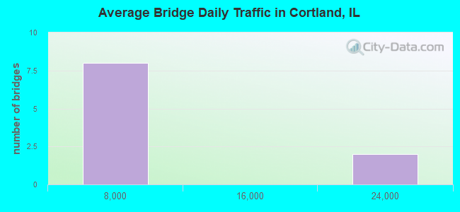
- 61,725Total average daily traffic
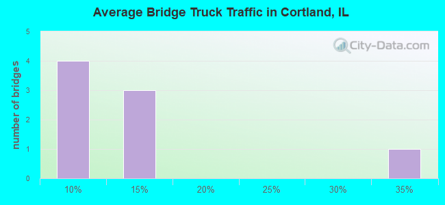
- 7,649Total average daily truck traffic
- National Bridge Inventory (NBI) Registered Bridges for Cortland
- No street view available for this location
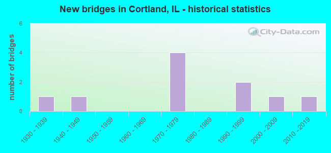
- New bridges - historical statistics
- 11930-1939
- 11940-1949
- 41970-1979
- 21990-1999
- 12000-2009
- 12010-2019
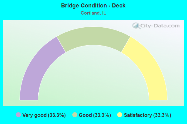
- Bridge Condition - Deck
- 33.3%Very good
- 33.3%Good
- 33.3%Satisfactory
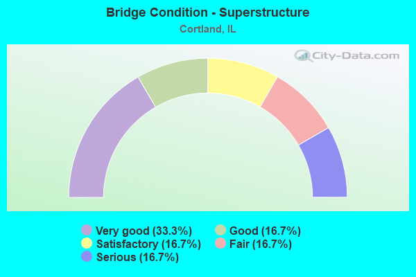
- Bridge Condition - Superstructure
- 33.3%Very good
- 16.7%Good
- 16.7%Satisfactory
- 16.7%Fair
- 16.7%Serious
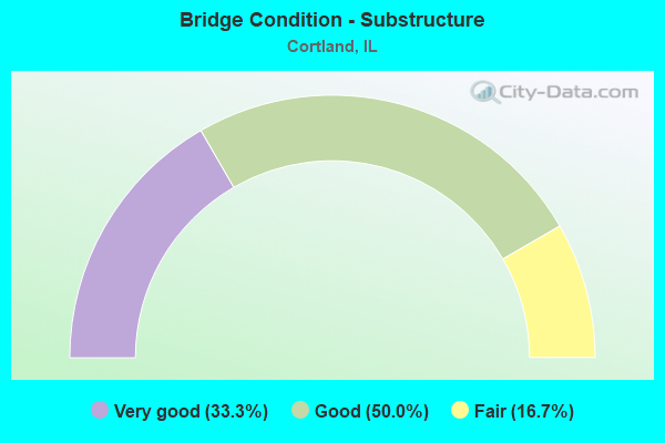
- Bridge Condition - Substructure
- 33.3%Very good
- 50.0%Good
- 16.7%Fair
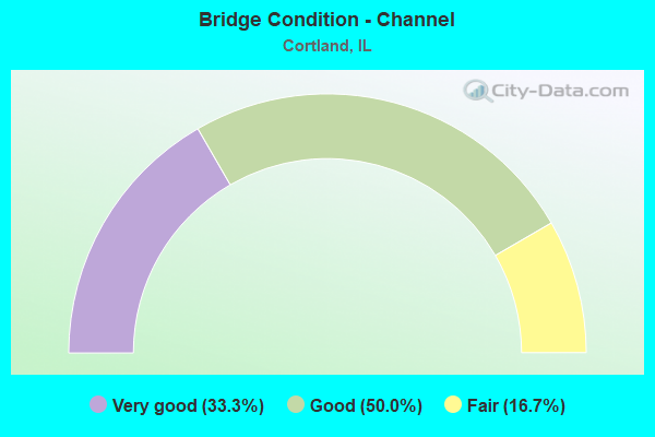
- Bridge Condition - Channel
- 33.3%Very good
- 50.0%Good
- 16.7%Fair
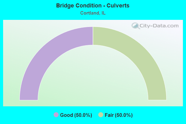
- Bridge Condition - Culverts
- 50.0%Good
- 50.0%Fair
Find on map >> Show street view
Structure Number: 190045, Location: 1.9 MI E SOMONAUK RD (Lat: 41.908800, Lng: -88.654983), Route carried "on" structure: State highway 38, Year Built: 2003, Status: Open, Structure Length: 1.88m (6.17ft), Average Daily Traffic: 7,000 (year 2021), Truck Traffic: 8%, Average Future Daily Traffic: 9,218 (year 2032), Design Load: HS 20, Features Intersected: UNION DITCH #1
Minimum Vertical Clearance: 30+ m (98+ ft), Kilometerpoint: 77.488, Lanes on structure: 2, Base Highway Network: Yes, Owner: State Highway Agency, Approaching Roadway Width: 12.2m (40.0ft), Material/Design: Steel, Design/Construction: Stringer/Multi-beam, Number Of Spans In Main Unit: 1, Number Of Approach Spans: 1, Length of Maximum Span: 18.0m (59.1ft), Curb-To-Curb Width: 12.2m (40.0ft), Out-to-Out Width: 13.2m (43.3ft)
Condition: Deck: Good, Superstructure: Very good, Substructure: Very good, Channel: Very good, Operating Rating: 80.4 metric tons, Method Used To Determine Operating Rating: Load Factor (LF) rating reported by rating factor (RF) method using MS18 loading, Inventory Rating: 48.3 metric tons, Method Used To Determine Inventory Rating: Load Factor (LF) rating reported by rating factor (RF) method using MS18 loading, Structural Evaluation: Equal to present desirable criteria, Deck Geometry: Somewhat better than minimum adequacy, Waterway Adequacy: Equal to present desirable criteria, Approach Roadway Alignment: Equal to present desirable criteria, Designated Inspection Frequency: Every 48 months, Inspection Date: Febuary 2021, Deck Structure Type: Concrete Cast-file-Place, Wearing Surface/Protective System: Deck Protection: Epoxy Coated Reinforcing
Find on map >> Show street view
Structure Number: 193043, Location: 1500N 1540E (Lat: 41.849789, Lng: -88.652681), Route carried "on" structure: County highway , Year Built: 1990, Status: Open, Structure Length: 0.86m (2.82ft), Average Daily Traffic: 2,150 (year 2021), Truck Traffic: 9%, Average Future Daily Traffic: 1,928 (year 2032), Design Load: HS 20, Features Intersected: Br of Battle Creek, Facility Carried by Structure: FAS-176 (Perry Rd)
Minimum Vertical Clearance: 30+ m (98+ ft), Kilometerpoint: 24.027, Lanes on structure: 2, Owner: County Highway Agency, Approaching Roadway Width: 9.1m (29.9ft), Skew: 3 degrees, Material/Design: Concrete, Design/Construction: Channel Beam, Number Of Spans In Main Unit: 1, Length of Maximum Span: 7.7m (25.3ft), Curb-To-Curb Width: 9.1m (29.9ft), Out-to-Out Width: 9.1m (29.9ft)
Condition: Deck: Good, Superstructure: Serious, Substructure: Fair, Channel: Good, Operating Rating: 56.1 metric tons, Method Used To Determine Operating Rating: Load Factor (LF) rating reported by rating factor (RF) method using MS18 loading, Inventory Rating: 33.4 metric tons, Method Used To Determine Inventory Rating: Load Factor (LF) rating reported by rating factor (RF) method using MS18 loading, Structural Evaluation: High priority of corrective action, Deck Geometry: Meets minimum limits, Waterway Adequacy: Better than present minimum criteria, Approach Roadway Alignment: Equal to present desirable criteria, Designated Inspection Frequency: Every 24 months, Inspection Date: April 2021, Deck Structure Type: Concrete Precast Panels, Wearing Surface/Protective System: Wearing Surface: Bituminous, Membrane: Built-up
Find on map >> Show street view
Structure Number: 193074, Location: 1500N 1490E (Lat: 41.849744, Lng: -88.662375), Route carried "on" structure: County highway , Year Built: 2014, Status: Open, Structure Length: 1.73m (5.68ft), Average Daily Traffic: 2,150 (year 2021), Truck Traffic: 9%, Average Future Daily Traffic: 2,000 (year 2035), Design Load: HS 25 or greater, Features Intersected: Battle creek, Facility Carried by Structure: perry rd.CH7
Minimum Vertical Clearance: 30+ m (98+ ft), Kilometerpoint: 23.222, Lanes on structure: 2, Owner: County Highway Agency, Approaching Roadway Width: 9.8m (32.2ft), Material/Design: Steel, Design/Construction: Stringer/Multi-beam, Number Of Spans In Main Unit: 1, Length of Maximum Span: 16.2m (53.1ft), Curb-To-Curb Width: 9.8m (32.2ft), Out-to-Out Width: 9.8m (32.2ft)
Condition: Deck: Very good, Superstructure: Very good, Substructure: Very good, Channel: Very good, Operating Rating: 42.1 metric tons, Method Used To Determine Operating Rating: Assigned ratings based on Load and Resistance Factor Design (LRFD) reported by rating factor (RF) using HL93 loadings, Inventory Rating: 32.4 metric tons, Method Used To Determine Inventory Rating: Assigned ratings based on Load and Resistance Factor Design (LRFD) reported by rating factor (RF) using HL93 loadings, Structural Evaluation: Equal to present desirable criteria, Deck Geometry: Meets minimum limits, Waterway Adequacy: Superior to present desirable criteria, Approach Roadway Alignment: Equal to present desirable criteria, Designated Inspection Frequency: Every 48 months, Inspection Date: December 2020, Deck Structure Type: Concrete Cast-file-Place, Wearing Surface/Protective System: Deck Protection: Epoxy Coated Reinforcing
Find on map >> Show street view
Structure Number: 194803, Location: 1890N 1500E (Lat: 41.905933, Lng: -88.659764), Route carried "on" structure: County highway , Year Built: 1932, Status: Open, Structure Length: 0.67m (2.20ft), Average Daily Traffic: 25 (year 2021), Average Future Daily Traffic: 30 (year 2032), Features Intersected: UNION DITCH NO 1, Facility Carried by Structure: CHASE ROAD/TR196A
Minimum Vertical Clearance: 30+ m (98+ ft), Kilometerpoint: 0.306, Lanes on structure: 2, Owner: Town or Township Highway Agency, Approaching Roadway Width: 6.1m (20.0ft), Material/Design: Concrete, Design/Construction: Slab, Number Of Spans In Main Unit: 1, Length of Maximum Span: 6.4m (21.0ft), Curb-To-Curb Width: 5.7m (18.7ft), Out-to-Out Width: 6.8m (22.3ft)
Condition: Deck: Satisfactory, Superstructure: Fair, Substructure: Good, Channel: Good, Operating Rating: 45.7 metric tons, Method Used To Determine Operating Rating: Load Factor (LF) rating reported by rating factor (RF) method using MS18 loading, Inventory Rating: 27.5 metric tons, Method Used To Determine Inventory Rating: Load Factor (LF) rating reported by rating factor (RF) method using MS18 loading, Structural Evaluation: Somewhat better than minimum adequacy, Deck Geometry: Meets minimum limits, Waterway Adequacy: Superior to present desirable criteria, Approach Roadway Alignment: Equal to present desirable criteria, Designated Inspection Frequency: Every 24 months, Inspection Date: January 2020, Deck Structure Type: Concrete Cast-file-Place
Find on map >> Show street view
Structure Number: 194805, Location: 1985N 1565E (Lat: 41.920683, Lng: -88.647539), Route carried "on" structure: City street , Year Built: 1947, Status: Open, Structure Length: 0.69m (2.26ft), Average Daily Traffic: 900 (year 2021), Truck Traffic: 30%, Average Future Daily Traffic: 1,265 (year 2032), Features Intersected: UNION DITCH #1, Facility Carried by Structure: AIRPORT RD
Minimum Vertical Clearance: 30+ m (98+ ft), Kilometerpoint: 0.306, Lanes on structure: 2, Owner: City or Municipal Highway Agency, Approaching Roadway Width: 7.9m (25.9ft), Material/Design: Concrete, Design/Construction: Culvert, Number Of Spans In Main Unit: 2, Length of Maximum Span: 3.0m (9.8ft)
Condition: Channel: Good, Culverts: Fair, Operating Rating: 40.5 metric tons, Method Used To Determine Operating Rating: Field evaluation and documented engineering judgment, Inventory Rating: 24.3 metric tons, Method Used To Determine Inventory Rating: Field evaluation and documented engineering judgment, Structural Evaluation: Somewhat better than minimum adequacy, Waterway Adequacy: Better than present minimum criteria, Approach Roadway Alignment: Equal to present desirable criteria, Designated Inspection Frequency: Every 24 months, Inspection Date: Febuary 2020
Find on map >> Show street view
Structure Number: 195112, Location: 1600N 1465E (Lat: 41.864275, Lng: -88.667192), Route carried "on" structure: County highway , Year Built: 1994, Status: Open, Structure Length: 0.71m (2.33ft), Average Daily Traffic: 25 (year 2021), Average Future Daily Traffic: 30 (year 2032), Design Load: HS 20, Features Intersected: BATTLE CREEK, Facility Carried by Structure: HARTER RD(TR165)
Minimum Vertical Clearance: 30+ m (98+ ft), Kilometerpoint: 3.412, Lanes on structure: 2, Owner: Town or Township Highway Agency, Approaching Roadway Width: 5.5m (18.0ft), Skew: 2 degrees, Material/Design: Concrete, Design/Construction: Culvert, Number Of Spans In Main Unit: 2, Length of Maximum Span: 3.4m (11.2ft)
Condition: Channel: Fair, Culverts: Good, Operating Rating: 44.1 metric tons, Method Used To Determine Operating Rating: Assigned rating based on Load Factor Design (LFD) reported by rating factor (RF) using MS18 loading, Inventory Rating: 32.4 metric tons, Method Used To Determine Inventory Rating: Assigned rating based on Load Factor Design (LFD) reported by rating factor (RF) using MS18 loading, Structural Evaluation: Better than present minimum criteria, Waterway Adequacy: Better than present minimum criteria, Approach Roadway Alignment: Equal to present desirable criteria, Designated Inspection Frequency: Every 48 months, Inspection Date: March 2019
Find on map >> Show street view
Structure Number: 199916, Location: 1 MI S CORTLAND (Lat: 41.900614, Lng: -88.689361), Route carried "on" structure: Other road , Year Built: 1974, Status: Open, Structure Length: 6.77m (22.21ft), Average Daily Traffic: 2,750 (year 2021), Truck Traffic: 14%, Average Future Daily Traffic: 4,037 (year 2032), Design Load: HS 20, Features Intersected: I-88, Facility Carried by Structure: SOMONAUK RD FAS 96
Minimum Vertical Clearance: 30+ m (98+ ft), Kilometerpoint: 9.752, Lanes on structure: 2, Lanes under structure: 4, Owner: State Toll Authority, Approaching Roadway Width: 13.4m (44.0ft), Material/Design: Prestressed concrete, Design/Construction: Stringer/Multi-beam, Number Of Spans In Main Unit: 4, Length of Maximum Span: 23.8m (78.1ft), Curb-To-Curb Width: 13.0m (42.7ft), Out-to-Out Width: 13.9m (45.6ft)
Condition: Deck: Satisfactory, Superstructure: Satisfactory, Substructure: Good, Operating Rating: 70.0 metric tons, Method Used To Determine Operating Rating: Load Factor (LF) rating reported by rating factor (RF) method using MS18 loading, Inventory Rating: 42.1 metric tons, Method Used To Determine Inventory Rating: Load Factor (LF) rating reported by rating factor (RF) method using MS18 loading, Structural Evaluation: Equal to present minimum criteria, Deck Geometry: Equal to present minimum criteria, Underclear: Somewhat better than minimum adequacy, Approach Roadway Alignment: Equal to present desirable criteria, Designated Inspection Frequency: Every 24 months, Inspection Date: August 2020, Deck Structure Type: Concrete Precast Panels
Find on map >> Show street view
Structure Number: 199917, Location: 2 MI W KANE CO (Lat: 41.894853, Lng: -88.639878), Route carried "on" structure: County highway , Year Built: 1974, Status: Open, Structure Length: 7.74m (25.39ft), Average Daily Traffic: 325 (year 2021), Truck Traffic: 5%, Average Future Daily Traffic: 542 (year 2032), Design Load: HS 20, Features Intersected: I-88, Facility Carried by Structure: HINCKLEY RD TR 206
Minimum Vertical Clearance: 30+ m (98+ ft), Kilometerpoint: 1.384, Lanes on structure: 2, Lanes under structure: 4, Owner: State Toll Authority, Approaching Roadway Width: 9.1m (29.9ft), Material/Design: Prestressed concrete, Design/Construction: Stringer/Multi-beam, Number Of Spans In Main Unit: 4, Length of Maximum Span: 27.4m (89.9ft), Curb-To-Curb Width: 8.1m (26.6ft), Out-to-Out Width: 9.1m (29.9ft)
Condition: Deck: Very good, Superstructure: Good, Substructure: Good, Operating Rating: 58.6 metric tons, Method Used To Determine Operating Rating: Load Factor (LF) rating reported by rating factor (RF) method using MS18 loading, Inventory Rating: 35.3 metric tons, Method Used To Determine Inventory Rating: Load Factor (LF) rating reported by rating factor (RF) method using MS18 loading, Structural Evaluation: Better than present minimum criteria, Deck Geometry: Somewhat better than minimum adequacy, Underclear: Somewhat better than minimum adequacy, Approach Roadway Alignment: Equal to present desirable criteria, Designated Inspection Frequency: Every 24 months, Inspection Date: July 2019, Deck Structure Type: Concrete Precast Panels
Find on map >> Show street view
Structure Number: 199916, Location: 1 MI S CORTLAND (Lat: 41.900614, Lng: -88.689361), Route carried "under" structure: Interstate 88, Year Built: 1974, Structure Length: 0. m, Average Daily Traffic: 23,200 (year 2020), Truck Traffic: 13%, Features Intersected: I-88, Facility Carried by Structure: SOMONAUK RD FAS 96
Minimum Vertical Clearance: 4.93m (16.17ft), Kilometerpoint: 153.994, Lanes on structure: 2, Lanes under structure: 4, Material/Design: Prestressed concrete, Design/Construction: Stringer/Multi-beam, Length of Maximum Span: 23.8m (78.1ft)
Find on map >> Show street view
Structure Number: 199917, Location: 2 MI W KANE CO (Lat: 41.894853, Lng: -88.639878), Route carried "under" structure: Interstate 88, Year Built: 1974, Structure Length: 0. m, Average Daily Traffic: 23,200 (year 2020), Truck Traffic: 13%, Features Intersected: I-88, Facility Carried by Structure: HINCKLEY RD TR 206
Minimum Vertical Clearance: 4.93m (16.17ft), Kilometerpoint: 158.339, Lanes on structure: 2, Lanes under structure: 4, Material/Design: Prestressed concrete, Design/Construction: Stringer/Multi-beam, Length of Maximum Span: 27.4m (89.9ft)