Bridge Statistics for Cornwells Heights-Eddington, Pennsylvania (PA)
Condition, Traffic, Stress, Structural Evaluation, Project Costs
- National Bridge Inventory (NBI) Statistics
- 10Number of bridges
- 39ft / 12.4mTotal length
- $1,197,000Total costs
- 216,025Total average daily traffic
- 16,211Total average daily truck traffic
- National Bridge Inventory (NBI) Registered Bridges for Cornwells Heights-Eddington
- No street view available for this location
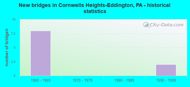
- New bridges - historical statistics
- 81960-1969
- 21990-1999

- Reconstructed bridges - Historical Statistics
- 11970-1979
- 01980-1989
- 11990-1999


- Bridge Condition - Deck
- 25.0%Good
- 50.0%Satisfactory
- 25.0%Fair

- Bridge Condition - Superstructure
- 25.0%Good
- 25.0%Satisfactory
- 50.0%Fair

- Bridge Condition - Substructure
- 25.0%Good
- 75.0%Satisfactory
Find on map >> Show street view
Structure Number: 6834, Location: 1MI.N. ANDALUSIA 45G03 (Lat: 40.073042, Lng: -74.951947), Route carried "on" structure: Interstate 95, Year Built: 1964, Year Reconstructed: 1981, Status: Open, Structure Length: 1.62m (5.31ft), Average Daily Traffic: 49,297 (year 2021), Truck Traffic: 7%, Average Future Daily Traffic: 56,086 (year 2032), Design Load: HS 20+Mod, Features Intersected: STATION AVENUE
Minimum Vertical Clearance: 30+ m (98+ ft), Kilometerpoint: 3.206, Lanes on structure: 3, Lanes under structure: 2, Base Highway Network: Yes, Owner: State Highway Agency, Approaching Roadway Width: 14.9m (48.9ft), Skew: 11 degrees, Material/Design: Prestressed concrete, Design/Construction: Box Beam or Girders - Single/Spread, Number Of Spans In Main Unit: 1, Length of Maximum Span: 15.8m (51.8ft), Curb or Sidewalk Widths: Left: 0.2m (0.7ft), Right: 0.2m (0.7ft), Curb-To-Curb Width: 15.8m (51.8ft), Out-to-Out Width: 17.5m (57.4ft)
Condition: Deck: Satisfactory, Superstructure: Satisfactory, Substructure: Satisfactory, Operating Rating: 61.7 metric tons, Method Used To Determine Operating Rating: Load Factor (LF), Inventory Rating: 30.8 metric tons, Method Used To Determine Inventory Rating: Load Factor (LF), Structural Evaluation: Equal to present minimum criteria, Deck Geometry: Somewhat better than minimum adequacy, Underclear: Somewhat better than minimum adequacy, Approach Roadway Alignment: Equal to present desirable criteria, Length Of Structure Improvement: 2.30m (7.55ft), Designated Inspection Frequency: Every 24 months, Inspection Date: Febuary 2020, Bridge Improvement Cost: $19,000, Roadway Improvement Cost: $57,000, Total Project Cost: $260,000, Deck Structure Type: Concrete Cast-file-Place, Wearing Surface/Protective System: Wearing Surface: Bituminous
Find on map >> Show street view
Structure Number: 689, Location: 3MI.N.PHILA.LINE 45K01 (Lat: 40.083481, Lng: -74.934714), Route carried "on" structure: State highway 132, Year Built: 1964, Status: Open, Structure Length: 6.89m (22.60ft), Average Daily Traffic: 23,834 (year 2021), Truck Traffic: 9%, Average Future Daily Traffic: 47,447 (year 2032), Design Load: HS 20, Features Intersected: INTERSTATE 95, Facility Carried by Structure: STREET ROAD
Minimum Vertical Clearance: 30+ m (98+ ft), Kilometerpoint: 24.295, Lanes on structure: 5, Lanes under structure: 12, Base Highway Network: Yes, Owner: State Highway Agency, Approaching Roadway Width: 18.3m (60.0ft), Skew: 20 degrees, Material/Design: Prestressed concrete, Design/Construction: Box Beam or Girders - Multiple, Number Of Spans In Main Unit: 2, Number Of Approach Spans: 2, Length of Maximum Span: 23.8m (78.1ft), Curb or Sidewalk Widths: Left: 1.5m (4.9ft), Right: 0.2m (0.7ft), Curb-To-Curb Width: 18.3m (60.0ft), Out-to-Out Width: 21.0m (68.9ft)
Condition: Deck: Fair, Superstructure: Fair, Substructure: Satisfactory, Operating Rating: 71.7 metric tons, Method Used To Determine Operating Rating: Load Factor (LF), Inventory Rating: 29.9 metric tons, Method Used To Determine Inventory Rating: Load Factor (LF), Structural Evaluation: Somewhat better than minimum adequacy, Deck Geometry: High priority of replacement, Underclear: Meets minimum limits, Approach Roadway Alignment: Better than present minimum criteria, Length Of Structure Improvement: 7.70m (25.26ft), Designated Inspection Frequency: Every 24 months, Inspection Date: January 2020, Bridge Improvement Cost: $45,000, Roadway Improvement Cost: $134,000, Total Project Cost: $612,000, Deck Structure Type: Concrete Cast-file-Place, Wearing Surface/Protective System: Wearing Surface: Bituminous
Find on map >> Show street view
Structure Number: 6891, Location: EDDINGTON 45K01 (Lat: 40.084058, Lng: -74.935206), Route carried "on" structure: State highway 132, Year Built: 1964, Year Reconstructed: 1999, Status: Open, Structure Length: 2.29m (7.51ft), Average Daily Traffic: 23,834 (year 2021), Truck Traffic: 9%, Average Future Daily Traffic: 47,447 (year 2032), Design Load: HS 20, Features Intersected: BRISTOL PIKE, Facility Carried by Structure: STREET ROAD
Minimum Vertical Clearance: 30+ m (98+ ft), Kilometerpoint: 23.414, Lanes on structure: 2, Lanes under structure: 4, Base Highway Network: Yes, Owner: State Highway Agency, Approaching Roadway Width: 20.1m (65.9ft), Skew: 20 degrees, Material/Design: Prestressed concrete, Design/Construction: Box Beam or Girders - Multiple, Number Of Spans In Main Unit: 1, Length of Maximum Span: 22.9m (75.1ft), Curb or Sidewalk Widths: Left: 0.2m (0.7ft), Right: 0.2m (0.7ft), Curb-To-Curb Width: 18.3m (60.0ft), Out-to-Out Width: 20.0m (65.6ft)
Condition: Deck: Satisfactory, Superstructure: Fair, Substructure: Satisfactory, Operating Rating: 96.2 metric tons, Method Used To Determine Operating Rating: Load Factor (LF), Inventory Rating: 40.8 metric tons, Method Used To Determine Inventory Rating: Load Factor (LF), Structural Evaluation: Somewhat better than minimum adequacy, Deck Geometry: Superior to present desirable criteria, Underclear: Meets minimum limits, Approach Roadway Alignment: Equal to present desirable criteria, Length Of Structure Improvement: 3.10m (10.17ft), Designated Inspection Frequency: Every 24 months, Inspection Date: January 2020, Bridge Improvement Cost: $24,000, Roadway Improvement Cost: $71,000, Total Project Cost: $325,000, Deck Structure Type: Concrete Cast-file-Place, Wearing Surface/Protective System: Wearing Surface: Bituminous
Find on map >> Show street view
Structure Number: 39446, Location: SEPTA PARK/RIDE 45G03 (Lat: 40.072861, Lng: -74.952033), Route carried "on" structure: Ramp State highway , Year Built: 1997, Status: Open, Structure Length: 1.58m (5.18ft), Average Daily Traffic: 71 (year 2021), Truck Traffic: 2%, Average Future Daily Traffic: 571 (year 2032), Design Load: HS 25 or greater, Features Intersected: STATION AVENUE, Facility Carried by Structure: RAMP W
Minimum Vertical Clearance: 30+ m (98+ ft), Kilometerpoint: 0.000, Lanes on structure: 1, Lanes under structure: 2, Base Highway Network: Yes, Owner: State Highway Agency, Approaching Roadway Width: 8.8m (28.9ft), Skew: 1 degrees, Material/Design: Prestressed concrete, Design/Construction: Box Beam or Girders - Single/Spread, Number Of Spans In Main Unit: 1, Length of Maximum Span: 15.8m (51.8ft), Curb or Sidewalk Widths: Left: 0.2m (0.7ft), Right: 0.2m (0.7ft), Curb-To-Curb Width: 8.8m (28.9ft), Out-to-Out Width: 9.9m (32.5ft)
Condition: Deck: Good, Superstructure: Good, Substructure: Good, Operating Rating: 78.9 metric tons, Method Used To Determine Operating Rating: Load Factor (LF), Inventory Rating: 42.6 metric tons, Method Used To Determine Inventory Rating: Load Factor (LF), Structural Evaluation: Better than present minimum criteria, Deck Geometry: Superior to present desirable criteria, Underclear: Somewhat better than minimum adequacy, Approach Roadway Alignment: Equal to present desirable criteria, Length Of Structure Improvement: 2.30m (7.55ft), Designated Inspection Frequency: Every 24 months, Inspection Date: July 2021, Deck Structure Type: Concrete Cast-file-Place, Wearing Surface/Protective System: Wearing Surface: Monolithic Concrete, Deck Protection: Epoxy Coated Reinforcing
Find on map >> Show street view
Structure Number: 6834, Location: 1MI.N. ANDALUSIA 45G03 (Lat: 40.073042, Lng: -74.951947), Route carried "under" structure: State highway , Year Built: 1964, Structure Length: 0. m, Average Daily Traffic: 6,056 (year 2022), Truck Traffic: 6%, Features Intersected: STATION AVENUE, Facility Carried by Structure: INTERSTATE 95 (SB)
Minimum Vertical Clearance: 4.45m (14.60ft), Kilometerpoint: 0.000, Lanes on structure: 3, Lanes under structure: 2, Material/Design: Prestressed concrete, Design/Construction: Box Beam or Girders - Single/Spread, Length of Maximum Span: 15.8m (51.8ft)
Find on map >> Show street view
Structure Number: 689, Location: 3MI.N.PHILA.LINE 45K01 (Lat: 40.083481, Lng: -74.934714), Route carried "under" structure: Interstate 95, Year Built: 1964, Structure Length: 0. m, Average Daily Traffic: 44,372 (year 2021), Truck Traffic: 8%, Features Intersected: INTERSTATE 95, Facility Carried by Structure: STREET ROAD
Minimum Vertical Clearance: 5.66m (18.57ft), Kilometerpoint: 4.833, Lanes on structure: 5, Lanes under structure: 6, Material/Design: Prestressed concrete, Design/Construction: Box Beam or Girders - Multiple, Length of Maximum Span: 23.8m (78.1ft)
Find on map >> Show street view
Structure Number: 689, Location: 3MI.N.PHILA.LINE 45K01 (Lat: 40.083481, Lng: -74.934714), Route carried "under" structure: Interstate 95, Year Built: 1964, Structure Length: 0. m, Average Daily Traffic: 44,587 (year 2021), Truck Traffic: 7%, Features Intersected: INTERSTATE 95, Facility Carried by Structure: STREET ROAD
Minimum Vertical Clearance: 5.26m (17.26ft), Kilometerpoint: 4.804, Lanes on structure: 5, Lanes under structure: 6, Material/Design: Prestressed concrete, Design/Construction: Box Beam or Girders - Multiple, Length of Maximum Span: 23.8m (78.1ft)
Find on map >> Show street view
Structure Number: 6891, Location: EDDINGTON 45K01 (Lat: 40.084058, Lng: -74.935206), Route carried "under" structure: US 13, Year Built: 1964, Structure Length: 0. m, Average Daily Traffic: 8,959 (year 2021), Truck Traffic: 6%, Features Intersected: BRISTOL PIKE, Facility Carried by Structure: STREET ROAD
Minimum Vertical Clearance: 4.36m (14.30ft), Kilometerpoint: 4.316, Lanes on structure: 2, Lanes under structure: 2, Material/Design: Prestressed concrete, Design/Construction: Box Beam or Girders - Multiple, Length of Maximum Span: 22.9m (75.1ft)
Find on map >> Show street view
Structure Number: 6891, Location: EDDINGTON 45K01 (Lat: 40.084058, Lng: -74.935206), Route carried "under" structure: US 13, Year Built: 1964, Structure Length: 0. m, Average Daily Traffic: 8,959 (year 2021), Truck Traffic: 6%, Features Intersected: BRISTOL PIKE, Facility Carried by Structure: STREET ROAD
Minimum Vertical Clearance: 4.51m (14.80ft), Kilometerpoint: 4.316, Lanes on structure: 2, Lanes under structure: 2, Material/Design: Prestressed concrete, Design/Construction: Box Beam or Girders - Multiple, Length of Maximum Span: 22.9m (75.1ft)
Find on map >> Show street view
Structure Number: 39446, Location: SEPTA PARK/RIDE 45G03 (Lat: 40.072861, Lng: -74.952033), Route carried "under" structure: State highway , Year Built: 1997, Structure Length: 0. m, Average Daily Traffic: 6,056 (year 2022), Truck Traffic: 6%, Features Intersected: STATION AVENUE, Facility Carried by Structure: RAMP W
Minimum Vertical Clearance: 6.99m (22.93ft), Kilometerpoint: 0.000, Lanes on structure: 1, Lanes under structure: 2, Material/Design: Prestressed concrete, Design/Construction: Box Beam or Girders - Single/Spread, Length of Maximum Span: 15.8m (51.8ft)