Bridge Statistics for Cornwall, Pennsylvania (PA)
Condition, Traffic, Stress, Structural Evaluation, Project Costs
- National Bridge Inventory (NBI) Statistics
- 14Number of bridges
- 95ft / 28.9mTotal length
- $3,467,000Total costs
- 118,345Total average daily traffic
- 12,526Total average daily truck traffic
- National Bridge Inventory (NBI) Registered Bridges for Cornwall
- No street view available for this location
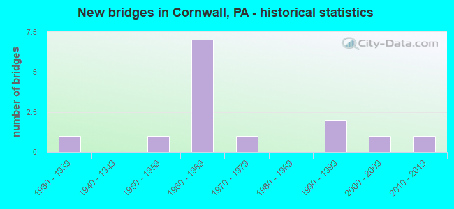
- New bridges - historical statistics
- 11930-1939
- 11950-1959
- 71960-1969
- 11970-1979
- 21990-1999
- 12000-2009
- 12010-2019

- Reconstructed bridges - Historical Statistics
- 11990-1999
- 32000-2009


- Bridge Condition - Deck
- 33.3%Very good
- 55.6%Good
- 11.1%Satisfactory

- Bridge Condition - Superstructure
- 20.0%Very good
- 60.0%Good
- 20.0%Satisfactory

- Bridge Condition - Substructure
- 10.0%Very good
- 40.0%Good
- 30.0%Satisfactory
- 20.0%Fair

- Bridge Condition - Channel
- 40.0%Satisfactory
- 60.0%Fair
Find on map >> Show street view
Structure Number: 21053, Location: 0.5 MI.N. OF ELSTONVILLE (Lat: 40.210422, Lng: -76.427353), Route carried "on" structure: State highway 72, Year Built: 1995, Status: Open, Structure Length: 1.83m (6.00ft), Average Daily Traffic: 11,694 (year 2020), Truck Traffic: 8%, Average Future Daily Traffic: 13,805 (year 2032), Design Load: HS 25 or greater, Features Intersected: CHICKIES CREEK
Minimum Vertical Clearance: 30+ m (98+ ft), Kilometerpoint: 23.902, Lanes on structure: 2, Base Highway Network: Yes, Owner: State Highway Agency, Approaching Roadway Width: 13.4m (44.0ft), Material/Design: Prestressed concrete, Design/Construction: Box Beam or Girders - Single/Spread, Number Of Spans In Main Unit: 2, Length of Maximum Span: 18.3m (60.0ft), Curb or Sidewalk Widths: Left: 0.2m (0.7ft), Right: 0.2m (0.7ft), Curb-To-Curb Width: 13.4m (44.0ft), Out-to-Out Width: 14.5m (47.6ft)
Condition: Deck: Good, Superstructure: Good, Substructure: Satisfactory, Channel: Satisfactory, Inventory Rating: 48.1 metric tons, Method Used To Determine Inventory Rating: Load Factor (LF), Structural Evaluation: Equal to present minimum criteria, Deck Geometry: Equal to present minimum criteria, Waterway Adequacy: Better than present minimum criteria, Approach Roadway Alignment: Better than present minimum criteria, Length Of Structure Improvement: 2.60m (8.53ft), Designated Inspection Frequency: Every 24 months, Inspection Date: March 2021, Deck Structure Type: Concrete Cast-file-Place, Wearing Surface/Protective System: Wearing Surface: Monolithic Concrete, Deck Protection: Epoxy Coated Reinforcing
Find on map >> Show street view
Structure Number: 22677, Location: 1 MI.S.W. CORNWALL (Lat: 40.265550, Lng: -76.435681), Route carried "on" structure: US 322, Year Built: 1963, Year Reconstructed: 2014, Status: Open, Structure Length: 5.70m (18.70ft), Average Daily Traffic: 22,784 (year 2022), Truck Traffic: 8%, Average Future Daily Traffic: 27,861 (year 2032), Design Load: HS 20, Features Intersected: SR 0117; ABANDONED RR
Minimum Vertical Clearance: 30+ m (98+ ft), Kilometerpoint: 15.221, Lanes on structure: 2, Lanes under structure: 2, Base Highway Network: Yes, Owner: State Highway Agency, Approaching Roadway Width: 19.5m (64.0ft), Skew: 32 degrees, Material/Design: Prestressed concrete, Design/Construction: Stringer/Multi-beam, Number Of Spans In Main Unit: 4, Length of Maximum Span: 16.2m (53.1ft), Curb or Sidewalk Widths: Left: 0.2m (0.7ft), Right: 0.2m (0.7ft), Curb-To-Curb Width: 17.9m (58.7ft), Out-to-Out Width: 20.0m (65.6ft)
Condition: Deck: Very good, Superstructure: Satisfactory, Substructure: Satisfactory, Operating Rating: 82.6 metric tons, Method Used To Determine Operating Rating: Load Factor (LF), Inventory Rating: 27.2 metric tons, Method Used To Determine Inventory Rating: Load Factor (LF), Structural Evaluation: Equal to present minimum criteria, Deck Geometry: Superior to present desirable criteria, Underclear: Meets minimum limits, Approach Roadway Alignment: Equal to present desirable criteria, Length Of Structure Improvement: 6.70m (21.98ft), Designated Inspection Frequency: Every 24 months, Inspection Date: August 2021, Bridge Improvement Cost: $223,000, Roadway Improvement Cost: $658,000, Total Project Cost: $3,015,000, Deck Structure Type: Concrete Cast-file-Place, Wearing Surface/Protective System: Wearing Surface: Monolithic Concrete, Membrane: Epoxy, Deck Protection: Epoxy Coated Reinforcing
Find on map >> Show street view
Structure Number: 22678, Location: CORNWALL BORO (Lat: 40.256822, Lng: -76.430911), Route carried "on" structure: US 322, Year Built: 1963, Year Reconstructed: 1997, Status: Open, Structure Length: 1.71m (5.61ft), Average Daily Traffic: 4,002 (year 2022), Truck Traffic: 5%, Average Future Daily Traffic: 4,490 (year 2032), Design Load: HS 20, Features Intersected: PA 72; SR 0072
Minimum Vertical Clearance: 30+ m (98+ ft), Kilometerpoint: 15.739, Lanes on structure: 1, Lanes under structure: 4, Base Highway Network: Yes, Owner: State Highway Agency, Approaching Roadway Width: 9.1m (29.9ft), Skew: 1 degrees, Material/Design: Prestressed concrete, Design/Construction: Stringer/Multi-beam, Number Of Spans In Main Unit: 1, Length of Maximum Span: 16.2m (53.1ft), Curb or Sidewalk Widths: Left: 0.2m (0.7ft), Right: 0.2m (0.7ft), Curb-To-Curb Width: 9.4m (30.8ft), Out-to-Out Width: 10.8m (35.4ft)
Condition: Deck: Satisfactory, Superstructure: Good, Substructure: Fair, Operating Rating: 78.9 metric tons, Method Used To Determine Operating Rating: Load Factor (LF), Inventory Rating: 36.3 metric tons, Method Used To Determine Inventory Rating: Load Factor (LF), Structural Evaluation: Somewhat better than minimum adequacy, Deck Geometry: Meets minimum limits, Underclear: Better than present minimum criteria, Approach Roadway Alignment: Equal to present desirable criteria, Length Of Structure Improvement: 2.40m (7.87ft), Designated Inspection Frequency: Every 24 months, Inspection Date: August 2021, Bridge Improvement Cost: $6,000, Roadway Improvement Cost: $18,000, Total Project Cost: $82,000, Deck Structure Type: Concrete Cast-file-Place, Wearing Surface/Protective System: Wearing Surface: Latex Concrete
Find on map >> Show street view
Structure Number: 22679, Location: CORNWALL BOROUGH (Lat: 40.257672, Lng: -76.380997), Route carried "on" structure: US 322, Year Built: 1963, Year Reconstructed: 2014, Status: Open, Structure Length: 4.02m (13.19ft), Average Daily Traffic: 8,003 (year 2022), Truck Traffic: 5%, Average Future Daily Traffic: 8,980 (year 2032), Design Load: HS 20, Features Intersected: Abandoned Railroad
Minimum Vertical Clearance: 30+ m (98+ ft), Kilometerpoint: 20.297, Lanes on structure: 2, Base Highway Network: Yes, Owner: State Highway Agency, Approaching Roadway Width: 12.2m (40.0ft), Skew: 3 degrees, Material/Design: Prestressed concrete, Design/Construction: Stringer/Multi-beam, Number Of Spans In Main Unit: 3, Length of Maximum Span: 13.1m (43.0ft), Curb or Sidewalk Widths: Left: 0.2m (0.7ft), Right: 0.2m (0.7ft), Curb-To-Curb Width: 13.1m (43.0ft), Out-to-Out Width: 14.1m (46.3ft)
Condition: Deck: Good, Superstructure: Good, Substructure: Satisfactory, Operating Rating: 77.1 metric tons, Method Used To Determine Operating Rating: Load Factor (LF), Inventory Rating: 29.0 metric tons, Method Used To Determine Inventory Rating: Load Factor (LF), Structural Evaluation: Equal to present minimum criteria, Deck Geometry: Somewhat better than minimum adequacy, Approach Roadway Alignment: Equal to present desirable criteria, Length Of Structure Improvement: 4.90m (16.08ft), Designated Inspection Frequency: Every 24 months, Inspection Date: August 2021, Bridge Improvement Cost: $16,000, Roadway Improvement Cost: $48,000, Total Project Cost: $219,000, Deck Structure Type: Concrete Cast-file-Place, Wearing Surface/Protective System: Wearing Surface: Monolithic Concrete, Membrane: Epoxy, Deck Protection: Epoxy Coated Reinforcing
Find on map >> Show street view
Structure Number: 22754, Location: 1.5 MI.S. LEBANON (Lat: 40.305769, Lng: -76.410542), Route carried "on" structure: State highway , Year Built: 1970, Year Reconstructed: 2013, Status: Open, Structure Length: 5.85m (19.19ft), Average Daily Traffic: 8,186 (year 2021), Truck Traffic: 5%, Average Future Daily Traffic: 12,202 (year 2032), Design Load: HS 20, Features Intersected: Abandoned RR - RJCN, Facility Carried by Structure: SR 2002 Rocherty r
Minimum Vertical Clearance: 30+ m (98+ ft), Kilometerpoint: 0.536, Lanes on structure: 2, Owner: State Highway Agency, Approaching Roadway Width: 11.0m (36.1ft), Material/Design: Prestressed concrete, Design/Construction: Box Beam or Girders - Single/Spread, Number Of Spans In Main Unit: 4, Length of Maximum Span: 14.9m (48.9ft), Curb or Sidewalk Widths: Left: 0.2m (0.7ft), Right: 0.2m (0.7ft), Curb-To-Curb Width: 13.4m (44.0ft), Out-to-Out Width: 14.6m (47.9ft)
Condition: Deck: Very good, Superstructure: Good, Substructure: Good, Operating Rating: 83.5 metric tons, Method Used To Determine Operating Rating: Load Factor (LF), Inventory Rating: 37.2 metric tons, Method Used To Determine Inventory Rating: Load Factor (LF), Structural Evaluation: Better than present minimum criteria, Deck Geometry: Equal to present minimum criteria, Approach Roadway Alignment: Equal to present desirable criteria, Length Of Structure Improvement: 6.90m (22.64ft), Designated Inspection Frequency: Every 24 months, Inspection Date: September 2021, Deck Structure Type: Concrete Cast-file-Place, Wearing Surface/Protective System: Wearing Surface: Latex Concrete
Find on map >> Show street view
Structure Number: 22871, Location: 2 S.LEB.CITY/SNITZ CREEK (Lat: 40.303583, Lng: -76.430547), Route carried "on" structure: City street , Year Built: 1962, Status: Open, Structure Length: 0.94m (3.08ft), Average Daily Traffic: 800 (year 2013), Truck Traffic: 5%, Average Future Daily Traffic: 1,960 (year 2033), Design Load: HS 20, Features Intersected: SNITZ CREEK, Facility Carried by Structure: ROCHERTY ROAD
Minimum Vertical Clearance: 30+ m (98+ ft), Kilometerpoint: 0.000, Lanes on structure: 2, Owner: Town or Township Highway Agency, Approaching Roadway Width: 7.9m (25.9ft), Material/Design: Concrete, Design/Construction: Slab, Number Of Spans In Main Unit: 1, Length of Maximum Span: 9.1m (29.9ft), Curb or Sidewalk Widths: Left: 0.5m (1.6ft), Right: 0.5m (1.6ft), Curb-To-Curb Width: 9.1m (29.9ft), Out-to-Out Width: 10.8m (35.4ft)
Condition: Deck: Good, Superstructure: Good, Substructure: Fair, Channel: Fair, Operating Rating: 68.0 metric tons, Method Used To Determine Operating Rating: Load Factor (LF), Inventory Rating: 40.8 metric tons, Method Used To Determine Inventory Rating: Load Factor (LF), Structural Evaluation: Somewhat better than minimum adequacy, Deck Geometry: Equal to present minimum criteria, Waterway Adequacy: Equal to present desirable criteria, Approach Roadway Alignment: Equal to present desirable criteria, Length Of Structure Improvement: 1.60m (5.25ft), Designated Inspection Frequency: Every 24 months, Inspection Date: April 2021, Wearing Surface/Protective System: Wearing Surface: Bituminous
Find on map >> Show street view
Structure Number: 22921, Location: COLEMAN ST OVER SNITZ CR. (Lat: 40.274164, Lng: -76.415075), Route carried "on" structure: City street , Year Built: 1930, Status: Open, Structure Length: 0.67m (2.20ft), Average Daily Traffic: 450 (year 2013), Truck Traffic: 5%, Average Future Daily Traffic: 840 (year 2033), Features Intersected: SNITZ CREEK, Facility Carried by Structure: BURD-COLEMAN ST.
Minimum Vertical Clearance: 30+ m (98+ ft), Kilometerpoint: 0.000, Lanes on structure: 2, Owner: City or Municipal Highway Agency, Approaching Roadway Width: 7.6m (24.9ft), Material/Design: Masonry, Design/Construction: Arch - Deck, Number Of Spans In Main Unit: 1, Length of Maximum Span: 6.7m (22.0ft), Curb-To-Curb Width: 7.6m (24.9ft), Out-to-Out Width: 9.1m (29.9ft)
Condition: Superstructure: Satisfactory, Substructure: Good, Channel: Fair, Operating Rating: 49.9 metric tons, Method Used To Determine Operating Rating: Field evaluation and documented engineering judgment, Inventory Rating: 32.7 metric tons, Method Used To Determine Inventory Rating: Field evaluation and documented engineering judgment, Structural Evaluation: Equal to present minimum criteria, Deck Geometry: Meets minimum limits, Waterway Adequacy: Better than present minimum criteria, Approach Roadway Alignment: Equal to present desirable criteria, Length Of Structure Improvement: 0.70m (2.30ft), Designated Inspection Frequency: Every 24 months, Inspection Date: April 2021, Bridge Improvement Cost: $11,000, Roadway Improvement Cost: $33,000, Total Project Cost: $151,000
Find on map >> Show street view
Structure Number: 22922, Location: CORNWALL BORO/SNITZ CRK. (Lat: 40.283506, Lng: -76.418611), Route carried "on" structure: City street , Year Built: 1993, Status: Open, Structure Length: 0.70m (2.30ft), Average Daily Traffic: 100 (year 2013), Truck Traffic: 5%, Average Future Daily Traffic: 420 (year 2033), Design Load: HS 20, Features Intersected: SNITZ CREEK, Facility Carried by Structure: N CORNWALL ROAD
Minimum Vertical Clearance: 30+ m (98+ ft), Kilometerpoint: 0.000, Lanes on structure: 2, Owner: City or Municipal Highway Agency, Approaching Roadway Width: 8.2m (26.9ft), Material/Design: Concrete, Design/Construction: Slab, Number Of Spans In Main Unit: 1, Length of Maximum Span: 6.7m (22.0ft), Curb-To-Curb Width: 8.5m (27.9ft), Out-to-Out Width: 9.5m (31.2ft)
Condition: Deck: Good, Superstructure: Good, Substructure: Good, Channel: Fair, Operating Rating: 83.5 metric tons, Method Used To Determine Operating Rating: Field evaluation and documented engineering judgment, Inventory Rating: 49.9 metric tons, Method Used To Determine Inventory Rating: Field evaluation and documented engineering judgment, Structural Evaluation: Better than present minimum criteria, Deck Geometry: Better than present minimum criteria, Waterway Adequacy: Better than present minimum criteria, Approach Roadway Alignment: Equal to present desirable criteria, Length Of Structure Improvement: 1.30m (4.27ft), Designated Inspection Frequency: Every 24 months, Inspection Date: May 2021, Wearing Surface/Protective System: Wearing Surface: Bituminous
Find on map >> Show street view
Structure Number: 46565, Location: RAPHO TWP (Lat: 40.229814, Lng: -76.438242), Route carried "on" structure: Ramp Interstate 76, Year Built: 2007, Status: Open, Structure Length: 5.58m (18.31ft), Average Daily Traffic: 4,021 (year 2010), Truck Traffic: 12%, Average Future Daily Traffic: 5,362 (year 2030), Design Load: HS 20, Features Intersected: PA TPK (I-76), Facility Carried by Structure: PA TPK (RAMP AB)
Minimum Vertical Clearance: 30+ m (98+ ft), Kilometerpoint: 0.000, Lanes on structure: 2, Lanes under structure: 5, Base Highway Network: Yes, Toll: On toll road, Owner: State Toll Authority, Approaching Roadway Width: 12.2m (40.0ft), Skew: 30 degrees, Material/Design: Steel continuous, Design/Construction: Stringer/Multi-beam, Number Of Spans In Main Unit: 2, Length of Maximum Span: 28.0m (91.9ft), Curb or Sidewalk Widths: Left: 0.2m (0.7ft), Right: 0.2m (0.7ft), Curb-To-Curb Width: 8.2m (26.9ft), Out-to-Out Width: 18.1m (59.4ft)
Condition: Deck: Very good, Superstructure: Very good, Substructure: Good, Operating Rating: 64.4 metric tons, Method Used To Determine Operating Rating: Load Factor (LF), Inventory Rating: 38.1 metric tons, Method Used To Determine Inventory Rating: Load Factor (LF), Structural Evaluation: Better than present minimum criteria, Deck Geometry: High priority of corrective action, Underclear: Better than present minimum criteria, Approach Roadway Alignment: Equal to present minimum criteria, Designated Inspection Frequency: Every 48 months, Inspection Date: March 2019, Deck Structure Type: Concrete Cast-file-Place, Wearing Surface/Protective System: Wearing Surface: Integral Concrete, Deck Protection: Epoxy Coated Reinforcing
Find on map >> Show street view
Structure Number: 54674, Location: CORNWALL (Lat: 40.289297, Lng: -76.426306), Route carried "on" structure: State highway 72, Year Built: 2017, Status: Open, Structure Length: 1.95m (6.40ft), Average Daily Traffic: 14,267 (year 2021), Truck Traffic: 5%, Average Future Daily Traffic: 17,908 (year 2032), Design Load: HL 93, Features Intersected: SNITZ CREEK
Minimum Vertical Clearance: 30+ m (98+ ft), Kilometerpoint: 5.353, Lanes on structure: 4, Base Highway Network: Yes, Owner: State Highway Agency, Approaching Roadway Width: 12.2m (40.0ft), Material/Design: Prestressed concrete, Design/Construction: Stringer/Multi-beam, Number Of Spans In Main Unit: 1, Length of Maximum Span: 18.3m (60.0ft), Curb or Sidewalk Widths: Left: 0.2m (0.7ft), Right: 0.2m (0.7ft), Curb-To-Curb Width: 21.3m (69.9ft), Out-to-Out Width: 22.4m (73.5ft)
Condition: Deck: Good, Superstructure: Very good, Substructure: Very good, Channel: Satisfactory, Operating Rating: 45.4 metric tons, Method Used To Determine Operating Rating: Assigned ratings based on Load and Resistance Factor Design (LRFD) reported by rating factor (RF) using HL93 loadings, Inventory Rating: 35.0 metric tons, Method Used To Determine Inventory Rating: Assigned ratings based on Load and Resistance Factor Design (LRFD) reported by rating factor (RF) using HL93 loadings, Structural Evaluation: Equal to present desirable criteria, Deck Geometry: Superior to present desirable criteria, Waterway Adequacy: Superior to present desirable criteria, Approach Roadway Alignment: Equal to present desirable criteria, Designated Inspection Frequency: Every 48 months, Inspection Date: September 2021, Deck Structure Type: Concrete Cast-file-Place, Wearing Surface/Protective System: Wearing Surface: Monolithic Concrete, Deck Protection: Epoxy Coated Reinforcing
Find on map >> Show street view
Structure Number: 21764, Location: N ELSTONVILLE (Lat: 40.229500, Lng: -76.432994), Route carried "under" structure: Interstate 76, Year Built: 1950, Structure Length: 0. m, Average Daily Traffic: 24,971 (year 2001), Truck Traffic: 24%, Features Intersected: PA TPK (I-76), Facility Carried by Structure: SR 0072, LR 138
Minimum Vertical Clearance: 5.14m (16.86ft), Kilometerpoint: 0.000, Lanes on structure: 2, Lanes under structure: 5, Material/Design: Steel, Design/Construction: Girder and Floorbeam System, Length of Maximum Span: 29.9m (98.1ft)
Find on map >> Show street view
Structure Number: 22677, Location: 1 MI.S.W. CORNWALL (Lat: 40.265550, Lng: -76.435681), Route carried "under" structure: State highway 117, Year Built: 1963, Structure Length: 0. m, Average Daily Traffic: 1,853 (year 2020), Truck Traffic: 7%, Features Intersected: SR 0117; ABANDONED RR, Facility Carried by Structure: US 322; SR 0322
Minimum Vertical Clearance: 6.41m (21.03ft), Kilometerpoint: 0.000, Lanes on structure: 2, Lanes under structure: 2, Material/Design: Prestressed concrete, Design/Construction: Stringer/Multi-beam, Length of Maximum Span: 16.2m (53.1ft)
Find on map >> Show street view
Structure Number: 22678, Location: CORNWALL BORO (Lat: 40.256822, Lng: -76.430911), Route carried "under" structure: State highway 72, Year Built: 1963, Structure Length: 0. m, Average Daily Traffic: 8,607 (year 2020), Truck Traffic: 8%, Features Intersected: PA 72; SR 0072, Facility Carried by Structure: US 322 EB; SR 0322
Minimum Vertical Clearance: 4.98m (16.34ft), Kilometerpoint: 2.058, Lanes on structure: 1, Lanes under structure: 2, Material/Design: Prestressed concrete, Design/Construction: Stringer/Multi-beam, Length of Maximum Span: 16.2m (53.1ft)
Find on map >> Show street view
Structure Number: 22678, Location: CORNWALL BORO (Lat: 40.256822, Lng: -76.430911), Route carried "under" structure: State highway 72, Year Built: 1963, Structure Length: 0. m, Average Daily Traffic: 8,607 (year 2020), Truck Traffic: 8%, Features Intersected: PA 72; SR 0072, Facility Carried by Structure: US 322 EB; SR 0322
Minimum Vertical Clearance: 5.18m (16.99ft), Kilometerpoint: 2.058, Lanes on structure: 1, Lanes under structure: 2, Material/Design: Prestressed concrete, Design/Construction: Stringer/Multi-beam, Length of Maximum Span: 16.2m (53.1ft)